| Fortress | ||
 | ||
Coat of arms  | ||
| State | Italy | |
|---|---|---|
| Region | Trentino Alto Adige | |
| Territory | South Tyrol | |
| Altitude | 749 m a.s.l. | |
| Surface | 61.77 km² | |
| Inhabitants | 989 (2015) | |
| Name inhabitants | Fortezzini / Franzensfester | |
| Prefix tel | 39 0472 | |
| POSTAL CODE | 39045 | |
| Time zone | UTC 1 | |
Position
| ||
| Institutional website | ||

Fortress (Franzensfeste in German) is a center of the Trentino Alto Adige.
To know
Geographical notes
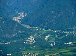
Fortezza is located in theUpper Valle Isarco 19 km south of Sterzing and 11 km north of Bressanone in Valle Isarco where the valley floor is only a few hundred meters wide. The inhabited center is located on the western side.
Background
Fortezza is a recently founded center; the town dates back to the nineteenth century, when the construction of the railway and fortifications began, to which the place is also closely linked in the name. The original municipality was Mezzaselva (Mittewald) with the two towns of Prà di Sopra (Oberau) and Prà di Sotto (Unterau). A small settlement was already present in 2500 BC, as shown by the discovery of domestic pottery. The place has always played an important role in the transit of goods on the north-south route; first like Via dell'Ambra between the Greece, the Sicily and northern Europe, then in the Roman period, between Aquileia and the regions beyond the Alps; this is demonstrated by a stretch of the Roman road found near the town.
The military importance of the place became evident during the Tyrolean uprising in 1809, when General Lefebvre, in command of 2,500 Saxon troops, was defeated in an ambush by Andreas Hofer's Tyroleans near the so-called Sachsenklemme (the "Saxon squeeze" "). Francis I, Emperor of Austria, at the time of building a defensive system, for fear of an invasion from the south, chose the place where the valley narrows and was built on the rocky ridge that juts out from the mountain for its geographical and strategic location. a first system of fortifications. The works began on June 17, 1833 and the Hapsburg Fort was inaugurated by Ferdinand I of Austria on August 18, 1838. Thousands of people contributed to the construction of the Fort - which was given the name of Francesco I, Franzensfeste - and subsequently to the railway. workers who found accommodation in Fortezza, contributing to the development and growth of the town.
In 1867, with the opening of the Brenner railway, Fortezza consolidated its role not only on the north-south route, but also towards the Val Pusteria up to Maribor, involving the southern part of the fortification in the construction of the line. With the signing of the pact of the Triple Alliance (1882), by the Empires of Germany, Austria-Hungary and of the Kingdom of Italy, the fortress of Fortezza lost its strategic-military importance and was transformed into an ammunition depot, a role it maintained even when it passed to Italy in 1918. In 1939 work began on the construction of the hydroelectric basin for the Bressanone power station, which was necessary for the electrification of the railway line; the works were completed the following year and Prà di Sotto was submerged by the reservoir.
In 1940 Fortezza was elevated to the status of a Municipality, became an important railway hub and both the infrastructures necessary for the maintenance of the locomotives and accommodation for the staff were built.Until the mid-nineties, Fortezza was an important customs office, especially for its stopover livestock; it lost much of its prominence after the opening of the borders, following the entry into the European Community of Austria.
How to orient yourself
Neighborhoods
Its municipal area also includes the villages of Le Cave / Grasstein, Mezzaselva / Mittewald and Pra di Sopra / Oberau
How to get
By plane
![]()
- 1 Bolzano-Dolomites Airport (IATA: BZO) (6 km from the center of Bolzano), ☎ 39 0471 255 255, fax: 39 0471 255 202.
 open to the public: 05: 30–23: 00; ticket office opening: 06: 00-19: 00; check-in for flights from Bolzano is only possible from 1 hour to a maximum of 20 minutes before departure. Small regional airport with scheduled flights to and from Lugano is Rome with Etihad Regional (by Darwin Air). At certain times of the year, the Lauda Air company connects the city with Vienna once a week. On the other hand, charter flights are more numerous.
 - 2 Verona Airport (Catullus), Boxes of Sommacampagna, ☎ 39 045 8095666, @[email protected].
- 3 Brescia Airport (D'Annunzio), Via Aeroporto 34, Montichiari (Connections with Brescia airport are guaranteed by public transport via the bus. The stop a Brescia city is located at the bus station (number 23), while the airport is at the front of the terminal. There are also connections to the city of Verona via bus / shuttle line 1), ☎ 39 045 8095666, @[email protected]. Charter only
By car
 Highway exit Bressanone-Val Pusteria on the highway of Brenner.
On the train
Despite its small size, Fortezza is an important railway junction that unites the Ferrovia della Val Pusteria with the Brenner line, or the Val Pusteria with the Valle Isarco.
By bus
 Public bus transport services in South Tyrol are managed by SAD [1]
How to get around
What see
- Parish Church of the Sacred Heart of Jesus (Herz-Jesu-Kirche). It is a relatively recent construction, erected in 1898/99 in neo-Romanesque style, to a design by Franz von Neumann of Vienna and the guidance of Josef Huber. Inside, the furnishings and similarly neo-Romanesque are from the period of 1900.
- In the centenary of the church, ancient frescoes representing the birth and resurrection of Christ were unearthed.
- Parish church of Mezzaselva. In the hamlet of Mezzaselva (Mittewald) there was a first church whose first evidence dates back to 1345. The church was rededicated in 1473. The current church is much more recent and is dedicated to San Martino. It was built between 1831 and 1833 under the direction of the curate of the Val di Vizze Jakob Prantl, integrating the late Gothic bell tower into the new church building. Important are the frescoes of the vault attributed to Josef Renzler of 1832, representing the adoration of the sacrament of the altar by the four continents and the death of San Martino. The four segments depict scenes from the life of the saint. The altarpieces are also by the artist Renzler and show the saint's death, the adoration of the magi and St. Sebastian.
- Cemetery chapel. It is dedicated to Sant'Isidoro, built in 1700 and consecrated in 1705. Inside the altar and the decorative stuccoes date back to the same period. On the walls of the building there are oil paintings of the life of the saint, while on the outside only traces of frescoes remain.
- Roman road. Traces of a Roman road have recently been found in Fortezza, which connected Sterzing with the Val Pusteria.

- Habsburg fortress, via Brennero, @[email protected]. The fortress was a military base until the mid-nineties, after which it was decommissioned. Subsequently, the property passed to the Bolzano State Property Agency, which in 2005 leased it to the municipality of Fortezza for 20 years. Exhibitions and sporting events are organized in the fortress.
- The fortress was also the last known location of the gold stolen by the Nazis from the Bank of Italy during the Second World War. Most of the 127 tons have all been lost.
- Around the fortress, there are 5 bunkers from World War II, which are part of the Fortezza del Vallo Alpino barrage in South Tyrol.
- Gampelefall Falls (Gampelefälle). There are two waterfalls located a few kilometers north of Fortezza, on its left hydrographic side: two interesting climbs that are easily accessible and also visible from the motorway.
- First waterfall (south) - Südlicher Gampelefall - You leave the highway a Bressanone and continue in the direction of the Brenner on the state road. You pass the town of Fortezza, and immediately notice the waterfalls on the right. It is therefore advisable to park the car near an old roadman and then go up into the woods to the base of the waterfall (about thirty minutes so far).
- Second waterfall (north) - Nördlicher Gampelefall - Continue by car to the base of the next waterfall, and go up the channel.

- Fortezza lake (Franzensfester See). It is an artificial lake formed by a dam that blocks the course of the Isarco river; it is located in a southern position with respect to the homonymous town of Fortezza.
- The dam was built in 1940 during Fascism, in the context of the policy of autarchy, to meet the growing energy needs. His project was developed in parallel with that of the Rio di Pusteria dam which generated the lake of the same name. Thus two reservoirs were created to convey the water (also through underground tunnels) to the hydroelectric plant of Bressanone.
- The construction of the Fortezza lake caused the side effect of the submersion of the village of Unterau / Prà di Sotto (as happened for Curon Venosta, for the construction of the Resia lake).
- On the southern shore of the lake stands the fortress entirely of granite commissioned by Emperor Francis I of Austria, built between 1833 and 1839 and crossed by the railway Val Pusteria.
- Near what would later become the lake, in the period just before the Second World War, five bunkers were built that were to prevent the access of Italy's enemies. These works were part of the Alpine Valley in South Tyrol and precisely of the Fortress barrage.
War plants
The Fortress barrage (in German Sperre Franzensfeste) is a barrage that is part of the XIV coverage sector of the Isarco del Alpine valley in South Tyrol, which is located near the fort of Fortezza; backward defense work, it also aimed to defend access to the episcopal city of Bressanone. Specifically, this defensive barrage, part of the III system, presented a course that starting from Punta di Quaira passed east on Mount Bruciato (German Brandeck), thus reaching the Chiusa di Rio barrage. There are five structures:

- 1 Opera 1. Just outside the town of Fortezza, proceeding southwards, on the left you cross a relatively new wooden pedestrian bridge, of the "ancient Roman road". Going along the little road (not well cared for and always subject to landslides) towards the south, after about 300 meters, you arrive at the highest point of the cycle path, where the protective wooden fence is interrupted by a strange shape: it is a turret, which it is located at street level (towards the lake). Going down the slope and following the trail (it has also been marked, probably by ENEL), there are several caponiere and loopholes to the north, while to the south, the entrances to the work.
- It develops very long, in fact it covers a large area on the edge of the lake of Fortezza. Of the three entrances to the work, one is accessible and appears disguised as if it were a loophole, and strangely faces the front line (to the north). The other two entrances, on the other hand, are, as typical, facing the opposite line to that of attack (south), and protected by a relative caponiera. Despite the great development of this work, it has only one chamber, but several points for the mouths of fire, subsequently adapted in the re-use of NATO. It is also equipped with a turret, visible as already mentioned from the ancient Roman road above. The work has 3 entrances.

- 2 Opera 2. From work 3, following a narrow and well-trodden path at the same altitude, after about 200 meters, at the height of the power line pole, work 2 is hidden. Of medium size, built in concrete, it has 2 entrances and a defense caponier placed between the two entrances. It is spread over two floors connected not only by a normal flight of stairs but also by a red seafaring staircase. Inside, fully furnished, there are also two cartons and one of the sheets to prevent humidity, and therefore water, from reaching the cartons of the pieces and flooding the fighting chamber; therefore with an operation similar to that of the gutters. You immediately notice how the ventilation system is practically new and shiny, thus maintained by the conditions of the work, just as the doors are still red paint. The work has 2 entrances.
- 3 Opera 3. From work 5, located along the cycle path and under a high voltage pole, take the path that leads to the new climbing wall and then to the Forte Alto di Fortezza; you walk along it for 20 meters and on the right you can see the restored entrance to the work, even if a little masked as it must have been originally.

- It was built in the early 1940s and reorganized in the 1960s to adapt it to changing operational needs. It was active until 1992 and closed permanently on 9 July 1993.
- The building is made of concrete, almost completely buried and (until a few years ago) covered with vegetation. The work is 290 m long with underground passages, arranged on various levels and on an area of 600 m². The entrances and workstations, the only parts visible from the outside, are well camouflaged with the typical masking.
- In the entrance room, or where the large dormitory room was located, some panels have been placed that describe the history of the bunker, the Fortezza barrage, the plan of the obstacles and the plan for the use of cannons and machine guns. The combat room positions have also been set up as they should have been originally. The whole bunker is also powered by 220 V, but with low-power bulbs (for safety reasons). In the upper part of the work there are two positions for external mortars (which is rare in the works of the Vallo Alpino), foreseen in the construction plan, but which were not reused after the war.

- 4 Opera 4. From work 1, continue on the cycle path for a further 500 meters; in the last stretch of the cycle path, looking at the Fortress down from the escarpment, then observing the dam, we notice the presence of work 4, small and built in concrete, very similar to work 5. It has 1 entrance.
- 5 Opera 5. Along the cycle path that goes from Fortezza to Bressanone, after having passed a sharp uphill hairpin bend (near the Fortress), you have to pay attention that you are right in front of Opera 5, which is right under the electricity pole.
- It is quite small and has a structure very similar to work 4. It has a telephone switchboard that puts it in direct contact with only work 3, located not far away. Inside, other than the structure to place the antenna outside, there is only one water tank. The work has 1 entrance.
Events and parties
What to do
Shopping
How to have fun
Where to eat
Average prices
- 1 Sachsenklemme restaurant, Via Sacco, 1, ☎ 39 0472 837837.
Where stay
Average prices
- Hotel al Ponte, via Parish 2, ☎ 39 0472 458644, fax: 39 0472 458050, @[email protected].
- Thaler Hotel, Freedom Square 1, ☎ 39 0472 458626.
- Hotel Posta Reifer, via Station 1, ☎ 39 0472 458605, fax: 39 0472 458828.
- Hotel Sachsenklemme, via Sacco 3, ☎ 39 0472 837837, fax: 39 0472 837877, @[email protected].
Safety
How to keep in touch
Post office
- 4 Italian post, via Riol 7, ☎ 39 0472 458618.
Around
- Bressanone - City with an important historical center enclosed by walls and gates. The Cathedral, his cloister with precious frescoes, the Bishop's Palace give an elegant imprint to the old city, with characteristic small villages that contrast with wide-ranging urban openings.
- Closed - Sabiona is the spiritual cradle of the whole of Tyrol. It was the bishopric of Tyrol (diocese of Sabiona), before it was moved to Bressanone around the year 1000. The monastery that stands there can be visited starting from Chiusa and walking along the path of an ancient Via Crucis.
- Brunico - Main center of the Val Pusteria, preserves two castles as well as historic districts of good interest. It is a city of tourism at the convergence of the tributary valleys of the Val Pusteria, all characterized by an environment of particular beauty.
- Sterzing- It is one of the most beautiful villages in Italy. Its historical core has remained almost intact in its 12th century conformation. Only a few tracts remain of the walls. Characteristic are the houses equipped with details bay windows or Erker, covered and closed projecting balconies.
- Varna - The Abbey of Novacella, in its municipal territory, is one of the most beautiful abbey complexes in Italy; it is in good condition.
Itineraries
- Castles of South Tyrol - A journey to discover the South Tyrolean manors which, born for military purposes, later became largely refined stately homes, centers of culture, examples of fine architecture, testimony to the greatness of the families who built them.
Other projects
 Wikipedia contains an entry concerning Fortezza (Italy)
 Commons contains images or other files on Fortezza (Italy)