
The Kalkeifel lies in the Eifel in Germany. The Kalkeifel consists of several limestone basins that are defined by geological formations. They lie between the geologically younger volcanic mountains and do not represent a closed area. They are more likely to be found in the northern Eifel than in the south.
Landscape and landmarks
Gerolsteiner and Hillesheimer Kalkmulde

In the Gerolsteiner and the Hillesheimer Kalkmulde overlap Volcano- and Kalkeifel, resulting in unique landscapes in which Quaternary volcanic cones overlay the Devonian limestone layers. This is particularly noticeable in the Papenkaule near Gerolstein, which can be reached on foot from Kasselburg, and the associated Sarresdorf lava flow. The limestone massif into which the volcanic explosion blasted the papenkaule is almost 100 meters above the river on the front Kyll towering stump of a Devonian reef that characterizes the cityscape of Gerolstein Munterley. In the immediate vicinity is found along the Eifelstiegs the Bärenloch, in which archaeological excavations discovered traces of Neanderthals.
One of the most famous fossil sites in Germany is located near the Gees district and is now under nature protection Trilobite fields near Gees, in which Alexander von Humboldt collected fossils.
Prümer Kalkmulde
The Prümer Kalkmulde is the largest of the Eifler Kalkmulde and the only one in the core of which there are still rocks from the Upper Devonian. The southwestern tip of the Prümer Kalkmulde is the Schönecker Switzerland, which was placed under nature protection because of the special importance of the landscape as the largest contiguous natural and near-natural part of the Prüm limestone basin.
Southwest of Schönecken there is also a geological peculiarity, the Wetteldorfer directional cut protected by the Ludwig-Happel-Hütte, the only GSSP (Global Stratotype Section and Point) in Germany, i. H. the point that is recognized worldwide as the separation between the geological level of the Eifelium and the Givetium.

Kalkeifel Cycle Path (2015)
Dreimühlen waterfall (2015)

Blackthorn blossom in Schönecker Switzerland

View into the Aubachtal, August 2017


places
in Rhineland-Palatinate
In North Rhine-Westphalia
Other goals
Nearby are also
- the Nürburgring
background
360 million years ago the Eifel was covered by seawater and corals grew on the seabed, which converted the ionic calcium into solid lime. Layers of limestone covered the sea floor. With the subsequent tectonic uplift of the land masses, the sea disappeared and the limestone layers now covered a low mountain range that was initially not very pronounced. The increasing tectonic activity led to volcanism (Vulkaneifel), which both lifted and destroyed the limestone layers.
Between the volcanoes there are hollows in which the limestone was preserved and which also benefited from the erosion of higher areas.
For more than 2000 years people have been using the rocks to mine lime. Even the Romans extracted and burned lime here. Watercourses are rather rare and small, as the water easily seeps away.
language
mobility
Tourist Attractions
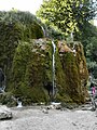
- Üxheim / Dreimühlen waterfall natural monument - the calcareous water builds up the waterfall.
- Roman lime distillery in Bad Münstereifel-Iversheim
- Nature reserve of the Schönecker Schweiz Prüm
- Rhenish open-air museum at Mechernich.
activities
hike
To go biking
The Kalkeifel cycle path is not suitable for the journey, as it is in the middle of the area. If you cycle it, you get to know the region without any problems. It is quite short and undemanding and also opens up the Kylltal if you do the tour on the Kylltal cycle path continues.
kitchen
nightlife
Religious motivation / pilgrimage
- Brother Klaus Chapel Guard Village, 21st century, in the sense of Nikolaus von der Flüe
- Salvatorian Monastery in Steinfeld
- Bad Münstereifel