 | ||
| Kamp-Lintfort | ||
| federal state | North Rhine-Westphalia | |
|---|---|---|
| Residents | 37.391 (2019) | |
| height | 33 m, 26 m | |
| no tourist info on Wikidata: | ||
| location | ||
| ||

Kamp-Lintfort is a left bank of the Rhine City on the western edge of the Ruhr area. It is best known for the Kamp monastery and as the end of the Autobahn 42.
background
The town of Kamp-Lintfort belongs to the district Wesel and is divided into eleven districts: Lintfort, Kamp, Niederkamp, Altfeld, Dachsbruch, Wickrath, Eyll, Geisbruch, Gestfeld, Hoerstgen, Kamperbruch, Niersenbruch, Kamperbrück, Rossenray and Saalhoff. City life takes place in Lintfort, originally a peasantry, which, however, had grown considerably due to the Friedrich Heinrich colliery. To the northwest of it lies Kamp with the monastery of the same name. In the far north of the urban area is the Leucht, an extensive forest area. Otherwise Kamp-Lintfort is also a green city.
getting there
Due to the nearby motorways, the city is very well connected regionally and nationally.
By plane
The nearest airports are in Dusseldorf (39 km, quickly accessible via the motorways) and Weeze (48 km north towards the Netherlands).
3 km north of the city center is the motor and glider airfield (Saalhoff special landing site, phone 49 02842/41010, GPS: N 51 ° 31'47 - E 6 ° 32'33), which is served by the Air sports community Kamp-Lintfort is operated. The 600 m long runway is used jointly by all aircraft and the nearby Düsseldorf Airport also requires increased attention.
By train
Kamp-Lintfort uses the existing railway lines only for the transport of goods and coal.
By bus
The Bus network is used by deer Niag and the VRR served. The central transfer point, where almost all lines stop, is the "Neues Rathaus" station in the middle of the city center. The SB30 express bus, which runs from Funds via Kamp-Lintfort and Moers leads to Duisburg. It runs every hour on weekdays from 5:30 a.m. to around 8:00 p.m. (in the direction of DU also every half hour), on Saturdays from 6:30 a.m. to 5:30 p.m. and on Sundays only 3 trips in the afternoon.
In the street
East of the city runs the A 57that north at Rheinberg, Alps and Goch leads past to the Netherlands. Via the A73 that follows there, you can Nijmegen (82km away) can be reached. The A 57 goes south to the south Neukirchen-Vluyn and Moers through over the A 40 away, continue on Krefeld, Neuss and Dormagen over to after Cologne (77km). Favorable exits on the A 57 from north to south:
- 7 "Rheinberg" leads over the B510 coming from the north into the city area
- 7a "Asdonkhof" is mostly used to get to the Wesel waste disposal company
- 8 "Kamp-Lintfort" leads to the city center via the L287 (north bypass) or Moerserstraße.
- also with the 8 the cross Kamp-Lintfort is designated
The A 42 begins at the Kamp-Lintfort junction (with the A 57) and heads east over the Rhine to the central Ruhr area (Duisburg, Oberhausen, Essen, Gelsenkirchen, Herne, Castrop-Rauxel and Dortmund). In the other direction (exit 1 "Kamp-Lintfort" of the A 42) the B528 connects, via which the city area can then be approached from the south.
By boat
mobility

Tourist Attractions
Churches, mosques, synagogues, temples
- 1 Kamp Monastery (Spiritual and cultural center Kloster Kamp e.V.), Kamp-Lintfort, Abteiplatz 13. Abbey church, museum, monastery cafe and shop, baroque terrace garden with orangeries (also belongs to Garden Art Route between the Rhine and Maas), also vaulted cellar, herb garden, playground. Regular Sunday vespers at 5 p.m. in the abbey church. Numerous cultural events: Chamber music festival and Kamper concerts, open-air theater on Abteiplatz, medieval market, Kamper night, evenings for connoisseurs or the Advent market.Open: The abbey church daily from 9:00 a.m. to 5:00 p.m. Baroque terrace garden open daily from 8:00 a.m. until dark; Monastery cafe / shop / vaulted cellar Mon-Fri & Sun from 11 a.m. to 5 p.m., Sat only open from 2 p.m. Museum Tue-Sat from 2 p.m. to 5 p.m., Sun / Fe from 11 a.m. to 5 p.m.Price: terrace garden free of charge.
Agathastift, Order Museum
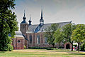
Abbey church
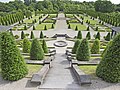
Terrace garden


Castles, chateaux and palaces
- Eyll Castle and Chapel
Buildings

- 2 Old settlement, Lintfort, Moerser-, Ring-, August- and Franzstraße. 76 hectare, listed miners' settlement in the style of the garden city. Belongs to Industrial Heritage Route.
- In 1907, work began on the Friedrich Heinrich colliery (today the West Mine, closed since 2012), and in 1909 the construction of the associated workers' settlement began. The oldest part is located between Ringstrasse, Albertstrasse and Ebertstrasse, where 1 1/2 to 2-storey houses were put together in groups of two and three. All had open front gardens as well as garden land for their own cultivation and a stable.
- The second construction phase lasted until World War I, it opened up the area to Moerser Strasse, Ringstrasse, Barbarastrasse, Alfredstrasse and Auguststrasse. Here the houses are constructed in a similar way, but with more varied architectural details. Between the world wars, several architects tried their hand at other streets, so that the appearance here is very inconsistent. In the 1950s, 6,000 people lived in 2,200 apartments.
- In the 1970s, there was renovation work with demolitions and the construction of high-rise buildings (the white giants), and further sins of construction were prevented after the settlers protested. The houses were renovated, equipped with modern comfort (private bathroom in the house) and mostly sold to the residents. Today the largest factory settlement in the Lower Rhine has an idyllic appearance. On the sides of the city to Design statute there is a map and notes on history and architecture.
- The casino now houses a hotel and restaurant.
Monuments

- Eugenia fossa. Remains of the canal between the Rhine and Meuse, which was started in 1626 but never completed. part of Industrial Heritage Route.
- The Fossa Eugenia was built by the Spaniards for two reasons: As a shipping canal between the Rhine and the Meuse, it was intended to cut off the breakaway Dutch provinces from trade on the Rhine and at the same time represent a defensive wall against them. The building was named after Isabella Clara Eugenia, the governor of the Spanish crown in the Netherlands.
- In 1629 the construction work was stopped again. There were financial reasons, there were technical problems with the hydraulic structures and the Dutch had carried out several raids. At that time they were in the middle of the 30 Years War.
- Today ground monuments are still visible in the areas of Rheinberg, Kamp-Lintfort, Geldern, Straelen and Venlo. From the Rhine to the Kamp district, the canal still carries water; it is used to drain the area. In the city there are still 2 of the 7 jumps ever preserved: on Eugeniastraße north of the Dachsberg and at Anhuf (GPS: N 51 ° 29'55, E 6 ° 28'31) in the district of Hoerstgen. There were a total of 24 jumps on the 50km long route.
- A cross-border path for hikers, cyclists and inline skaters has been set up about 60km long, the area is entitled Free time without limits marketed. Nordic walking routes, thermal baths and events are also offered.
activities
In 2020 the state horticultural show will take place until October North Rhine-Westphalia held at two locations in the city. Due to the corona pandemic, the garden show did not open until the beginning of May.[1]
shop
kitchen
nightlife
accommodation
Learn
Work
security
health
Practical advice
trips
literature
Web links
https://www.kamp-lintfort.de/ - Official website of Kamp-Lintfort
Individual evidence
- ↑A month's horticultural show: "The decision to open was the right one" Retrieved July 15, 2020.