| Rossana Maiorca cycle path (Syracuse) | |
 | |
| Itinerary type | Cycle lane |
|---|---|
| State | Italy |
| Region | Sicily |
| Territory | Syracusan |
| City | Syracuse |
| Length | 6.56 km |
| Time | 30 min |
Rossana Maiorca cycle path is an itinerary that develops through the former railway line of Syracuse.
Introduction
The track is one of the most evocative in Sicily due to the beauty of the marine panorama and the many naturalistic-archaeological attractions.
Geographical notes

The cycle path runs along the north-eastern coastal area of the city. The coast is rocky and full of archeologically interesting points. The area has no particular differences in height except for the crags that differentiate the coast from the innermost parts.
The coast is characterized by the presence of the two Due Frati rocks and further north of the bay of Santa Panagia with an adjoining canyon which in the area takes the name of quarry.
Background
The railway line along the stretch of coast north of Syracuse was decommissioned in 1998. With the decommissioning of the section, a debate began regarding the new intended use. In the end, opting for the construction of a cycle path, even if it cannot properly be defined as a cycle path but a cycle and pedestrian path. The route was inaugurated in 2009.
In 2013 it was named after the freediving champion and daughter of Enzo Maiorca, Rossana Maiorca.
When to go
The cycle path can be visited all year round. However, in the summer, due to the high temperatures and the impossibility of having points of shade during the day, it is strongly discouraged. However, in the same season the area is frequented by swimmers who meet at the two solariums built by the Municipality and freely accessible.
Who is it for?
For those who want to take a bike ride, for sportsmen who want to run or train in the open air. To tourists who want to discover a particularly suggestive stretch of coast.
For those who love off-piste routes, using a mountain bike you can follow the paths along the cliff, although they are not always easy to read.
How to get
By plane
- Catania-Fontanarossa Airport - with domestic flights to all Italian cities, and flights to the main European destinations and various international locations.
- Comiso airport - It mostly carries out seasonal, charter and low cost airlines flights to some Italian and European cities.
On the train
- 1 Syracuse central station, Station Square.
 Timetable. The station has:
 Ticket office at the counter,
  Automatic ticket office,
  Waiting room,
  Toilet,
  Cafe,
Cafe,  Restaurant,
  Tourist information office,
  Railway Police Station.
- Going out in the open space of the station, on the left there is a bar that also carries out the luggage storage.


By bus
- 2 Extra-urban bus terminal, Via Rubino, ☎ 39 0931 66710, 39 0935 22460, 39 091 345791 (numbers for Interbus), 39 06164160 (Buscenter). Departures to and from Catania, Palermo, Ragusa, Modica, Known, Avola, Pachino is Portopalo through the company Interbus or AST from Noto e Sortino. The company Buscenter connects with various cities of the Puglia, with Naples is Rome.
- The Interbus ticket office is located at the terminal. The indication of the stop of the individual buses may not be clearly indicated. It is advisable to ask passengers or drivers where to wait for the bus.
Stages
Due to its limited extension, the route does not include real stops but points of interest that can be taken into consideration by the cycle path itself. It is generally crossed by the War Memorial, but can be visited from both directions.

- 3 Latomia dei Cappuccini, via Puglia, ☎ 39 329 2417142, @[email protected].
 Full € 5, reduced € 3. On request. This latomia is certainly one of the most evocative places in the city, it is a quarry from the Greek era famous for being one of the places where Athenian soldiers were massed after the defeat of the fleet in the waters of Syracuse in 413 BC. Later it became the property of the nearby Capuchin convent, transforming into a lush garden with various species of plants and a small theater for summer performances.
.jpg/220px-Monumento_ai_Caduti_italiani_d'Africa_06_(cropped).jpg)
- 4 Monument to the Italian Fallen of Africa. It is a monument dating back to the fascist era. It was originally intended for the city of Addis Ababa, in Ethiopia, but with the outbreak of the Second World War and the loss of the Italian colonies of Africa, the Italian government decided to transfer the work to Syracuse. The monument commemorates the Italian soldiers who died during the Ethiopian War waged by the fascist government of Benito Mussolini, and more generally commemorates all the Italian soldiers who died in Africa in the colonial and war years. It was placed in that spot in 1952 when the work on assembling the pieces was started and inaugurated in 1968.

- 5 Scoglio Due Fratelli (The ru 'Frati). They are two rocks facing the coast line whose name derives from an urban legend according to which two brothers unfortunately died in that touch of the sea. In addition to being a popular spot in the city, in the summer it becomes a destination for many bathers. Here the municipality builds a free solarium.
_2.jpg/220px-Parco_delle_sculture_(Siracusa)_2.jpg)
- 6 Sculpture park (Linear park). It is a permanent exhibition of sculptures and art installations along the cliff overlooking the cycle path. Inaugurated in 2015, there were 10 works that have been vandalized over time and of which only a few remain intact, such as "Fragments of a love speech" (the bench) and "Every wall is a door" (the stone wall).

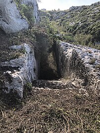
- 7 Trenches of the Second World War (follow the path that leads from the cycle path to the coast then turn left). These are three trenches built with stone blocks built in a broken line. They were guarding the bay of Santa Panagia and were used during the landing of the allies in August 1943. They are quite recognizable even if some parts have partially collapsed.
- 8 Santa Panagia quarry. It is a small canyon that opened onto the nearby bay. The presence of the bridge of the former railway has altered its characteristics. On the bottom there is a stream of water that reaches the sea through a tunnel under the old railway line. It can be accessed via two recently rediscovered flights of stairs. The 9 stairs on the south side are quite large and carved into the rock, while the 10 stairs on the opposite side they arrive right in the middle of an ancient latomia.
Scala Santa Panagia south

Path in the Cava Santa Panagia
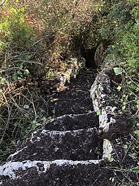
Scala Santa Panagia north


- 11 Former Santa Panagia Station. It was a railway stop on the Messina-Syracuse line which reached right in front of the tonnara. The train stop was abolished at the end of the sixties of the last century. Today the building is abandoned.

- 12 Tonnara of Santa Panagia. The complex of buildings of the trap remained in operation until the fifties when it became almost inactive due to the introduction of tuna fishing with "flying nets", as well as the high concentration of industries and chemical refineries in the area. After 1961, the tonnara fell into disuse. Currently the trap is in serious conditions of degradation.

- 13 Rock Church of Santa Panagia (From the access road to the trap, turn right and descend along the steps carved into the rock, then continue past the vegetation). The rock church is today identifiable as a cave overlooking the bay of Santa Panagia, inside are hardly legible frescoes and several niches. The oratory probably dates back to the Byzantine era.

- 14 Water source of the Colombe (From the cliff you go down along some stone steps.). A small spring of fresh water that curiously discharges directly into the sea a few centimeters high. In that stretch of coast, especially towards the west coast line, you can see how the cliff is formed by an overlap of two different rocks, the white limestone at the top and a dark-colored volcanic rock at the bottom.

- 15 Latomie (to the right and left of the cycle path, at a higher altitude). The indicated position shows the signs of a latomia, an ancient limestone quarry used in Greek times for the construction of the Dionysian Walls that closed the city and had a length of 17 km. Their presence indicates the proximity of the walls. In addition to the steps, several sections are visible with blocks just sketched in groups of three. These were extracted by placing wooden wedges which, once wet, expanded and caused the rock to break. The block was then finished and affixed. Many stretches along the coast of the cycle path have quarries. This is one of the most interesting.


- 16 Dionysian walls. They are a wall built by the tyrant Dionysius I of Syracuse between 402 BC. and 397 BC to fortify the Epipolis plateau still devoid of fortifications. The walls completely encircled the ancient city of Syracuse for a perimeter of 21 km. They are to be considered the largest in the Classical World, surpassing even the Aurelian Walls of Rome. The stretch indicated crosses the former railway track descending towards the cliff and then continuing southwards. This point is one of the few to show the blocks still intact and overlapping for two or three orders. In fact, along the coast the blocks were removed for other uses, making one lose memory of their location. Next to the walls are visible some quarries from which the blocks were removed. In the upper part of the plateau a short stretch of Greek carriageway is also visible.
- 17 Greek necropolis and carriages (From the cycle path it is necessary to climb over the walls to access it. The area is theoretically fenced). This area, which is located next to the
 it was formerly the access road to the city for those who came from Catania. On the outcropping rock the signs of chariots and several graves are evident, probably from the late imperial era.
Safety
The cycle path is in beaten earth which in some places is uneven due to the washout of the rain. It is not uncommon to find sections where the side barriers are broken, with a consequent risk of falling into the nearby ditches.
Many coastal stretches close to the cliff are officially not accessible due to possible collapses. Where there is no prohibition, it is always important to maintain the utmost caution to avoid falls from the cliff, in this regard it is necessary to avoid overhanging.
Avoid going along the cycle path at night, many stretches, especially those beyond the Due Frati rocks, run along degraded neighborhoods and in general these parts are not very busy after dark.
Around

- 18 Door Scea, via San Cataldo (At the end of the road, drive north on the unpaved stretch for about ten meters). The Scea gate was part of the defensive system of the city in Greek times. Located on the northern side of the city, it was not far from the Exapilon gate just below the road axis of Viale Scala Greek. This door together with the Exapilon constituted the doors that allowed to move in the direction of Catania. The traces of the wagons and the layout of the defensive walls are clearly visible on the spot. This site, practically unknown to Syracusans and official guides, is totally neglected as you can see but it is an important piece of the city's history. As far as possible, the signs of the carriageways that extend towards the north are evident.
- 19 Stentinello, via Stentinello. It is a prehistoric settlement on the northern outskirts of Syracuse close to the industrial area. This is an area where the holes for the laying of the hut poles have been identified. Today the site is hard to read and not easy to identify, but its findings, which constitute an important aspect of Sicilian prehistory, can be found in the Paolo Orsi museum.
Other projects
 Wikipedia contains an entry concerning Rossana Maiorca cycle path
 Commons contains images or other files on Rossana Maiorca cycle path