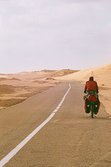
The Western Sahara cycle route leads from Guelmin in Morocco above Mauritania until after Saint Louis in the Senegal. It's 2100 km through that Western Sahara, whereby the westernmost part of the Sahara bordering the sea is meant and not the disputed area Sahara Arab Democratic Republic.

background
The route is paved throughout from Morocco to Senegal. Only a few kilometers on the Moroccan-Mauritanian border are soft sandy slopes (As of 2006) There are supply options at least every 150 km, corresponds to 2 - 3 driving days. This route is currently the easiest way to cross by bike from North Africa to the Sub-Saharan countries.
geography
The Western Sahara is geographically divided, starting from Cape Boujdour, into a northern part in which the flat, undulating gravel and scree deserts (Hammada) predominate. The terrain here rises gradually from the coast inland to a height of around 400 meters. To the south of the cape it is almost completely flat with isolated sand dunes (erg), which provide little variety in the uniform, almost vegetation-free rocky plain.
Grass and bush areas as well as acacias mark the transition from the desert steppe to the thorn savannah of the Sahel in southern Mauritania.
One finds animal species adapted to the dry habitat, for example scorpions, snakes, gerbils and thorn-tailed agamas. In the caves on the Atlantic coast, especially on the Cabo Blanco Peninsula near Nouadhibou in Mauritania, live the largest populations of the critically endangered Mediterranean monk seal.
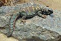
Thorntail agame (Uromastycinae)

Thick-tailed scorpion (Androctonus australis)
_juvenile_(16156642643).jpg/120px-Puff_Adder_(Bitis_arietans)_juvenile_(16156642643).jpg)
Puff adder (Bitis arietans)


_juvenile_(16156642643).jpg/120px-Puff_Adder_(Bitis_arietans)_juvenile_(16156642643).jpg)
climate
The Sahara is a tropic desert, caused by the constant, dry and hot NE trade winds. Even in the age of sailing, the trade winds were used as powerful tow lifts[1]. Even on a bike, the Passat constantly pushes you towards the south. But it also transports a lot of dust and sand close to the ground.
Especially in spring and autumn, severe low pressure areas over the Mediterranean can draw in Sahara air. The dry, hot southern to southeastern sand and dust winds, the sirocco, arise. Due to the large amounts of sand dust, the air turns yellowish-reddish-brown. The strong headwind can make it difficult to go south and quickly get you into an uncomfortable situation.
Along the coast, north of Nouakchott, the temperatures are moderate due to the balancing influence of the Atlantic. The cold Canary Current provides for the cooling, but is also responsible for the heavy fog in the coastal area. At the turn of the year it is 20 ° C, in September and October the temperature rises to 30 ° C.
On the coast south of Nouakchott and in the region along the Senegal River it is 20-24 ° C at the turn of the year and rises to 30-34 ° C in July. Especially in the south, the humidity is significantly higher with a rainy season in July - October with a total of 400 mm of precipitation.
| Ad Dakhla | Jan | Feb | March | Apr | May | Jun | Jul | Aug | Sep | Oct | Nov | Dec | ||
|---|---|---|---|---|---|---|---|---|---|---|---|---|---|---|
| Mean highest air temperature in ° C | 20.9 | 22.7 | 23.7 | 23.3 | 24 | 24.8 | 25.7 | 26.5 | 27.4 | 26.6 | 25.1 | 22.5 | O | 24.4 |
| Mean lowest air temperature in ° C | 13.3 | 13.8 | 14.7 | 14.9 | 15.8 | 16.7 | 17.5 | 18.3 | 18.8 | 18 | 16.6 | 14.5 | O | 16.1 |
| Precipitation in mm | 2 | 3 | 1 | 0 | 0 | 0 | 1 | 2 | 11 | 6 | 3 | 10 | Σ | 39 |
https://www.wetter.de/ wetter.de | ||||||||||||||
| Nouakchott | Jan | Feb | March | Apr | May | Jun | Jul | Aug | Sep | Oct | Nov | Dec | ||
|---|---|---|---|---|---|---|---|---|---|---|---|---|---|---|
| Mean highest air temperature in ° C | 28.8 | 30.4 | 32.5 | 32.8 | 34 | 33.3 | 31.7 | 32.1 | 34.1 | 34.9 | 32.7 | 29.2 | O | 32.2 |
| Mean lowest air temperature in ° C | 12.7 | 14.3 | 16.7 | 17.8 | 19.6 | 21.8 | 23.4 | 24.1 | 24.3 | 21.8 | 18 | 14 | O | 19 |
| Precipitation in mm | 0 | 2 | 2 | 0 | 0 | 0 | 14 | 37 | 28 | 7 | 1 | 7 | Σ | 98 |
https://wetter.de/ wetter.de | ||||||||||||||
| Saint Louis | Jan | Feb | March | Apr | May | Jun | Jul | Aug | Sep | Oct | Nov | Dec | ||
|---|---|---|---|---|---|---|---|---|---|---|---|---|---|---|
| Mean highest air temperature in ° C | 30 | 32.1 | 33.6 | 33.9 | 33.9 | 33.8 | 32.4 | 32.8 | 33.6 | 35 | 33.6 | 30.7 | O | 33 |
| Mean lowest air temperature in ° C | 15.4 | 16.1 | 17.5 | 18.2 | 19.6 | 22.1 | 23.6 | 24.3 | 24.3 | 22.6 | 19.3 | 16 | O | 19.9 |
| Precipitation in mm | 1.6 | 1.3 | 0.4 | 0 | 0.4 | 7.6 | 42.4 | 89.7 | 84.9 | 24 | 0.9 | 1.3 | Σ | 254.5 |
Travel time
The Western Sahara is, in principle, navigable all year round. Rain is rare and fog formation occurs mainly near the coast. Due to the proximity to the sea, the temperatures are softened. The wind usually blows from north to south, only in spring and autumn you have to expect headwinds through the sirocco. The winter months with the coolest temperatures and stable trade winds have a slight advantage in the choice of the travel time.
Travel time
Due to the trade winds, daily stages of 80 kilometers are realistic. Then it would be about 30 days of driving Guelmin to Saint Louis. In addition, there are days of stay in the larger cities and border crossings.
preparation
The situation can change drastically quickly along the route. Settlements can change, roads become impassable due to shifting dunes. Much of the information on the Internet or in books relates to the route before 2005, when the road was not yet developed. Back then, you had to tackle larger sections on sandy slopes. Therefore always check that the information is up-to-date.
Therefore, detailed research is necessary before departure. The locals as well as other travelers are a valuable source.
health
Water is certainly the first thing that comes to mind when traveling through the desert. The daily per capita consumption of drinking water is around 5 liters[2]. For tours further inland, with more extreme temperatures of up to 6 liters and more. In addition, there is the need for water to cook.
It is best to avoid the midday heat and drive in the early morning and afternoon. In the case of the large loss of fluid through sweating, the loss of salt should also be compensated for. The WHO recommends one teaspoon of salt and 6 teaspoons of sugar per liter of water[3]. However, too much salt or sugar can aggravate dehydration. The Rehydration Project uses only half a teaspoon of salt with 6 teaspoons of sugar in one liter of water[4]. Contrary to popular belief, one cannot adapt to a lack of water.
The consumption of water for cooking can be reduced by using water-saving foods. For a cup of couscous, you need a cup of water for rice twice as much.
By bicycle
The first choice would be a touring bike. With 28 '' tires you can make fast progress on the asphalt and still be prepared for desert trips. A steel frame is ideal, although difficult to find these days[5]. If the frame breaks, steel is easier to weld than aluminum.
Sand and dust act like sandpaper on the sprockets and the chain stretches under the loads. To increase the longevity, you can take two or three chains with you and change them every 800 - 1000 km. This means that the drive can reach distances of up to 10,000 km. Then you should change the entire drive system[6].
Cook
The supply of gas cartridges is sparse in Western Sahara. You can get fuel for gas stoves in every major town.
getting there
Guelmim is the last place before the desert and the starting point of the bike tour. Guelmim itself is a small town and only has bus connections. The closest major cities with airports are 1 Essaouira![]()
![]()
![]() (Arabic:الصويرة, DMG as-Ṣawīra), 400 km from Guelmin, and 2 Agadir
(Arabic:الصويرة, DMG as-Ṣawīra), 400 km from Guelmin, and 2 Agadir![]()
![]()
![]()
![]() (Arabic:أكادير), 200 km from Guelmin. There are bus connections to both of them 3 Tiznit
(Arabic:أكادير), 200 km from Guelmin. There are bus connections to both of them 3 Tiznit![]()
![]()
![]()
![]()
![]() (Arabic:تيزنيت, DMG Tīznīt). From there it is another 110 km to Guelmin.
(Arabic:تيزنيت, DMG Tīznīt). From there it is another 110 km to Guelmin.


Guelmim
4 Guelmim![]()
![]()
![]() (Arabic:كلميم, Too Goulimine or Guelmin) is a 118318 Provincial capital with inhabitants in the region Guelmim-Oued Noun. The space Bir Anzarane is the center of the city. You can find them here 1 Banque Populaire with ATM and that 1 Post office. The 1 Bus station is north of the square, along the Blvd Moulay Rachid.
(Arabic:كلميم, Too Goulimine or Guelmin) is a 118318 Provincial capital with inhabitants in the region Guelmim-Oued Noun. The space Bir Anzarane is the center of the city. You can find them here 1 Banque Populaire with ATM and that 1 Post office. The 1 Bus station is north of the square, along the Blvd Moulay Rachid.

route

from Guelmin to Tan Tan (130 km)
You leave Guelmin via the Avenue 3 Mars Towards the southwest. Passing the mosque of Guelmin you pass the city gate.
- 2 Crossing the Oued Siyad
- 3 From here to Ait Yassine and Aferkat, to Ait Yassine 11 km, to Aferkat 20 km
- 4 Bus hut, junction to Labyar (arabic:البيار) (44 km to Guelmin). Location is 2.5 km north.(28 ° 48 '24 "N.10 ° 24 ′ 21 ″ W.)
- Simple restaurant (50 km to Guelmin). Simple restaurant on a small hill.
- 5 Rass Oumlil settlement with restaurant and Magasin (70 km to Guelmin). (28 ° 40 ′ 6 ″ N.10 ° 38 ′ 10 ″ W.)
- view (88 km to Guelmin). Hill (2 km driveway) with a beautiful view.
- 5 Crossing the Oued Draa


 in der Datenbank Wikidata") who after his long way from Zagora flows through the desert only a few kilometers further west into the sea.
who after his long way from Zagora flows through the desert only a few kilometers further west into the sea.

Tan tan
6 Tan tan![]()
![]()
![]()
![]() (Arabic:طانطان, DMG Ṭānṭān, also al-Hamra (the Red)), is a 73209 City with population and capital of the province of the same name in the region Guelmim-Oued NounThe city is south of the main road Ave Hassan IIon which you can use the 2 post and the bank 2 BMCE, with ATM, next to the Shell petrol station. The second main street is the Ave Mohammed Vthat crosses the city to the south. On it is the3 Banque Populaire and on Place de la Marche Verte to the south of the Ave Mohammed V, the 6 Bus station (Gare Routière).The 7 Tan Tan Airport
(Arabic:طانطان, DMG Ṭānṭān, also al-Hamra (the Red)), is a 73209 City with population and capital of the province of the same name in the region Guelmim-Oued NounThe city is south of the main road Ave Hassan IIon which you can use the 2 post and the bank 2 BMCE, with ATM, next to the Shell petrol station. The second main street is the Ave Mohammed Vthat crosses the city to the south. On it is the3 Banque Populaire and on Place de la Marche Verte to the south of the Ave Mohammed V, the 6 Bus station (Gare Routière).The 7 Tan Tan Airport![]()
![]() (IATA: TTA)Plage Blanche Airport is 8 km west of the N1. It is served by the Royal Air Maroc, which Tan Tan with Casablanca and Guelmin connects.
(IATA: TTA)Plage Blanche Airport is 8 km west of the N1. It is served by the Royal Air Maroc, which Tan Tan with Casablanca and Guelmin connects.

from Tan Tan to Tarfaya (213 km)
If you leave Tan Tan to the west on the N1 after 6 km you reach the junction for Airport. One kilometer further on it turns left R101 from that up to 240 km away 7 Smara![]()
![]()
![]()
![]() (Arabic:السمارة) In the south. Shortly thereafter, a slope turns right that leads to the 35 km away 1 Mouth of the Oued Drâa
(Arabic:السمارة) In the south. Shortly thereafter, a slope turns right that leads to the 35 km away 1 Mouth of the Oued Drâa![]()
![]()
![]() leads into the Atlantic. 25 km after Tan Tan is reached 8 El Ouatia
leads into the Atlantic. 25 km after Tan Tan is reached 8 El Ouatia![]()
![]() (Arabic: الوطية, Too Tan Tan Plague). There are guarded parking spaces on the beach.
(Arabic: الوطية, Too Tan Tan Plague). There are guarded parking spaces on the beach.


El Ouatia
El Ouatia, with his 9295 Inhabitants is one of the largest fishing ports in Morocco. The city is becoming increasingly popular with surfers and has many hotels. At the entrance to the city you pass a roundabout from which the N1 pivots south. Straight ahead into the city. The piste to the north leads to the mouth of the 30 km away Oued Drâa in the Atlantic. This is found next to the roundabout 1 Korea House Hotel ( 212 641-431661)
- 2 Camping Atlantique Tantan
- 3 Camp Sables d'Or
- 4 Camping Equinox Tan Tan
- 5 Riad Essadia
- 2 Café Asfi
- 3 Bergach restaurant
The N1 runs up in their way south Akhfenir very close to the imposing cliff. After about 35 km you cross the 8 Oued Chbika(28 ° 17 '24 "N.11 ° 31 '59 "W.). After the driveway from the wadi comes a checkpoint with supply options.
- Further 9 Oued traverse
- 10 Oued traverse (70 km to El-Ouatia). with checkpoint at 2 petrol stations with café.(28 ° 10 ′ 30 ″ N.11 ° 52 ′ 50 ″ W.)
- 11 Devil's hole (also Gouffre d'Akhfenir or Trou du diable). Hole in the floor.(28 ° 6 ′ 25 ″ N.12 ° 2 ′ 17 ″ W.). A hole about 25 meters in diameter and 30 meters deep


- 9 Akhfenir (about 90 km to Ouatia). Small place with supply options and ATM.(28 ° 5 '43 "N.12 ° 3 ′ 0 ″ W.)(2280 Residents)
Akhfenir
South of Akhfenir is one of the largest wind farms in Africa with 131 wind turbines on an area of over 8,900 hectares. A runway leads from Akhfenir to the wind farm 20 km away, which was listed in 2015 in Jeune Afrique magazine as one of the “Ten Most Outstanding Projects in Africa”.[7]
- 7 Hotel Restaurant Atlas
- 8 Hotel Sahara Beach
- 4 Oumaïma pastry shop
- 12 Gas station
- 10 La Courbine d'argent
From Akhfenir the coast becomes flatter again. After about 10 km it bends N1 from the coast and runs in an arc around the 2 Khenifiss National Park![]()
![]()
![]() (Arabic:المنتزه الوطني اخنيفيس, French: Parc National de Khenifiss).
(Arabic:المنتزه الوطني اخنيفيس, French: Parc National de Khenifiss).

Khenifiss National Park
The Khenifiss National Park was established in 2006 from what was then a nature reserve and covers 1,850 km². As early as 1998, the park was named UNESCO World Natural Heritage listed.[8] The park is located on the largest lagoon on the Moroccan coast. Rusty goose (Tadorna ferruginea), marbled duck (Marmaronetta angustirostris) and coral gull (Ichthyaetus audouinii) breed here.[9]The mainland is characterized by sabchas, shallow basins that only carry water at times. Cuvier gazelles (Gazella cuvieri) have also been sighted here.[9]In Akhfenir there are numerous guides for tours in the national park.
Offers photo excursions
Sand dunes in the national park
Rust goose

Marble duck

Coral gull

Cuvier Gazelle


After the national park meets the N1 the coast again. You pass a small one about 163 km after Ouatia 5 Coffee shop without toilet on the coast and one 3 Wreck on the beach
After 35 km you will find a petrol station at the 13 Crossing before Tarfaya(27 ° 56 '49 "N.12 ° 53 ′ 8 ″ W.). The N1 turns south direction El Aaiún. If you follow the street straight ahead, you will reach it after 5 km 10 Tarfaya![]()
![]()
![]()
![]() (27 ° 56 ′ 0 ″ N.12 ° 55 ′ 0 ″ W.) (Arabic:طرفاية, DMG Ṭarfāya). Worth seeing Museum about the mail flights and Fort Jubly. Bank and ATM are also available.
(27 ° 56 ′ 0 ″ N.12 ° 55 ′ 0 ″ W.) (Arabic:طرفاية, DMG Ṭarfāya). Worth seeing Museum about the mail flights and Fort Jubly. Bank and ATM are also available.

Tarfaya


Tarfaya is a small town with 8027 Residents at Cape Juby in the region Laayoune-Sakia El Hamra. The city is the administrative center of the province of the same name.
The main street through the city is Ave Ahmed Haidar. You can find it where it turns south in the west 4 Banque PopulaireOn the beach there is a monument in the form of a green plane for the mail flights. Among other things, the writer and pilot Antoine de Saint-Exupéry was stationed here. In addition, the4 Antoine de St Exupery MuseumAbout 1 km off the coast are the ruins of the fortress built by the English in the 1880s5 Casa MarAt the beginning of 2008 a ferry connection between Tarfaya and Puerto del Rosario recorded in Fuerteventura. That gave Tarfaya a modest economic upturn until the car ferry Assalama Struck a leak in the port of Tarfaya in April 2008 and stranded in the shallow water where it lies to this day.[10]
- 12 Hotel Canalina, Ave Mohamed V (next to Center de Santé). Tel.: 212 641 785 521. (27 ° 56 ′ 30 ″ N.12 ° 55 ′ 24 ″ W.)
- 6 Cafe Boufous, Ave Ahmed Haidar.
- 5 Attijariwafa Bank, Rue Mejjat.
- 3 Pharmacie de Place Saint Exupery, Ave Qaied Baba Ahmed Oueld Youssef.
- 4 post
- 7 Snack restaurant Le9 Delice
- 6 Marché municipial
from Tarfaya to El Aaiún (104 km)
If you leave the city to the south, you will reach you 6 Roundabout. The road straight south leads back to the N1. A road branches off to the right, which follows the coast closer to Foum ed Oued leads (Condition unknown).
After 30 km at the N1 one reaches
. 45 km after Tarfaya you pass it
After 100 km you will reach 8 El Aaiún![]()
![]()
![]() (27 ° 9 ′ 0 ″ N.13 ° 12 ′ 0 ″ W.)
(27 ° 9 ′ 0 ″ N.13 ° 12 ′ 0 ″ W.)

El Aaiún

El Aaiún (Arabic:العيون, DMG al-ʿUyūn, also Laayoune) is with 217732 Inhabitants, the largest city in the Western Sahara territory administered by Morocco and the capital of the Moroccan administrative region Laayoune-Sakia El Hamra.
Most banks, hotels and the post office are located on Blvd Hassan II or Blvd de Mecca. The most important square in the city is the 9 Place du Mechouar.
El Aaiun Hassan I Airport (ICAO: GSAI / GMML) is located 2 km southwest of the N1. He is most commonly used by Royal Air Maroc and from the Canarian Binter canarias approached. The goals are spread across three countries, Las Palmas (Spain), Agadir, Casablanca, Ad-Dakhla and Rabat (Morocco) as well Paris-Orly (France).
information
- 7 Banque Populaire (ATM), Place Dchira.
- 8 BMCE (ATM), Place Dchira.
- 9 BMCE (ATM), Place Hassan II.
- 5 Royal Air Maroc, Place Dchira.
- 10 Ensemble Artisanale, Blvd de Mecca.
Worth seeing
- 10 Spanish Cathedral of St. Francis of Assisi, Ave Hassan II. located in a beautiful park.
- 11 Souq Djal. the liveliest district in town and the best food.
- 12 Moulay Abdel Aziz Mosque, Moulay Youssef Blvd.
- Smara (Arabic:السمارة), Capital of the province It semara is about the N5 reachable. It is 240 km inland into an almost vegetation-free solid stone and sand desert.


from El Aaiún to Boujdour (193 km)
The Ave Mohammed V goes to the Place du Mechouar N1 across that leads west out of town. Past the airport, it turns 13 km after Place du Mechouar sharp south direction El Marsa. The road branches off at the bend 11 Foum el Oued which can be reached after a further 6 km.
Foum el Oued
Foum el Oued (Arabic:فم الواد), Also known as the Sahara Riviera, is especially popular with the locals.
- 13 Camping Nile. Simple, clean, only cold water, restaurant only in summer.(27 ° 10 ′ 35 ″ N.13 ° 23 '36 "W.)
From Foum el Oued it is 10 km along the coastal road Ave Ennahda to 12 El Marsa![]()
![]()
![]()

El Marsa
El Marsa (Arabic:المرسى, Also Laâyoune Plage) with about 10,000 inhabitants is the last town to Boujdour, 160 km further south. There are a few simple cafes and shops.
- 8 Café el Puerto
- Hotel Marsa, Ave Hassan II.
Shortly after the southern end of the village you pass on the N1 the longest in the world at 100 km 13 Conveyor belt(27 ° 2 '37 "N.13 ° 24 ′ 54 ″ W.). It transports the phosphate from the mining town of Bou Craa (Arabic:بوكراع) To the loading port at El Marsa.[11]
- 14 Turn off to Plage Kerouma (22 km to El Marsa). Restaurant on the beach.(26 ° 54 ′ 19 ″ N.13 ° 27 ′ 35 ″ W.)
- 15 Lamsid (arabic:لمسيد) (82 km to El Marsa). Place with supply in the gas station restaurant.(26 ° 32 '25 "N.13 ° 50 ′ 36 ″ W.)
80 km after Lamsid is reached 16 Boujdour![]()
![]()
![]() (26 ° 8 ′ 0 ″ N.14 ° 29 ′ 0 ″ W.)
(26 ° 8 ′ 0 ″ N.14 ° 29 ′ 0 ″ W.)
.jpg/320px-Ruta_N1_a_la_salida_de_Bojador_(Sahara_Occidental).jpg)
Boujdour
Boujdour (Arabic:بوجدور) Is the 42651 Capital with inhabitants of the province of the same name in the region occupied by Morocco Laayoune-Sakia El Hamra at Cape Bojador (Arabic:رأس بوجادور, French: Cape BoujdourIt forms the western foothills of the mountain range Jebel el Aswad in the Sahara and was considered the western end of the world (finis terrae) in the Middle Ages. Here you will find the highest known dunes (erg) with up to 130 meters on the flat coastal plain, which otherwise consists of Hammada.
Along the N1, as Ave Hassan II Passing the city, the main shops, restaurants and hotels thread.
- 14 CTM
- 17 Gas station
- 6 post
- 11 Marché
- 15 Taxi station
- 16 Bus station (Gare Routière)
- 9 Cafe Marina
- 14 Hotel Al Qods
from Boujdour to Ad-Dakhla (345 km)
- 18 Two wrecks (18 km to Boujdour). Slope right to the beach, 2 wrecks.(25 ° 58 ′ 9 ″ N.14 ° 30 ′ 6 ″ W.)
- 19 wreck(25 ° 57 ′ 28 ″ N.14 ° 31 ′ 11 ″ W.)
- 10 Coffee shop (140 km to Boujdour). First café since Boujdour, no supply options in between.(24 ° 58 ′ 31 ″ N.14 ° 48 ′ 56 ″ W.)
- 20 Sahara gas station (148 km to Boujdour). Simple restaurant and petrol station, shortly afterwards turn off to the fishing village of L'Bir.(24 ° 54 ′ 39 ″ N.14 ° 49 ′ 12 ″ W.)
- 21 Oued Karaa (واد لكراع, Real Oucan) (180 km to Boujdour). Café, restaurant and gas station.(24 ° 40 ′ 7 ″ N.14 ° 52 ′ 11 ″ W.)
- 22 N'Tireft (نتيرفت) (24 ° 4 ′ 20 ″ N.15 ° 35 ′ 0 ″ W.)
- 23 unknown (280 km after Boujdour and 60 km before Dakhla). Gas station, restaurant.(24 ° 3 '38 "N.15 ° 34 '14 "W.)
- 24 Dakhla-Argoub intersection. Crossing Dakhla-Arghoub with gas station, restaurant and checkpoint. 40 km to Ad-Dakhla.(23 ° 53 '32 "N.15 ° 40 ′ 22 ″ W.)
- 16 unofficial campsite (10 km after the turnoff to Dakhla). Unofficial campsite in the spit with viewing pavilion, toilet.(23 ° 54 ′ 2 ″ N.15 ° 47 ′ 11 ″ W.)
Ad-Dakhla

- 25 Ad-Dakhla (الداخلة, al-Dāḫila, also Dakhla, earlier Villa Cisneros) (23 ° 43 ′ 0 ″ N.15 ° 57 ′ 0 ″ W.)Ad-Dakhla (106277 Inhabitants) is the southernmost city in the Western Sahara claimed by Morocco and the capital of the administrative region Dakhla-Oued Ed Dahab.

Dakhla is located on a 38 kilometer long and four kilometer wide headland, which extends in a south-westerly direction parallel to the coast and the bay, Rio de Oro encloses. The adjacent mainland and the peninsula consist of an almost vegetation-free sand and gravel plain (Reg). The west coast of the peninsula, which is open to the sea, has kilometers of sandy beaches north of the city between short rocky sections, which only because of the great distance to the Moroccan tourist resorts The city extends along the east side of the peninsula with the Mohammed V Blvd as a promenade. The main shopping street runs parallel to the north Boulevard Walae. To the south, around the great mosque, extends the business district Dakhla airport![]()
![]()
![]() (IATA: VIL) is served several times a week from Casablanca.
(IATA: VIL) is served several times a week from Casablanca.

information
- 26 Great mosque
- 17 CTM buses
- 12 BMCE Bank
- 18 Grande Taxi
- 13 Banque Populaire
- 27 Notre Dame de Carmen church
eat
- 14 Marché Municipal envelope, Boulevard Al Masjid.
- 15 Boulangerie
- 16 Supermarché Errihimi
- 17 Supermarché Aït Oubaha, Rue Oued Tansift.
- 18 Bakery Assalam, Rue Oued Tansift.
- 11 Café Oued Eddahab
- 12 Samarkand restaurant, Mohammed V Blvd.
Accommodations
- 17 Hotel Erraha
from Ad-Dakhla to Guerguerat (367 km)
- 28 El Argoub (arabic:العرڭوب) (40 km after the Dakhla-Arghoub intersection). Scattered settlement with a café, restaurant and simple shops.(23 ° 33 '33 "N.15 ° 53 '57 "W.)
- 30 Chica gas station (50 km to El Argoub). Turn right on the slope to the village of Chika.(23 ° 12 '28 "N.16 ° 5 ′ 44 ″ W.)
- 31 Barbas (arabic:برباس) (210 km to el Argoub).Hotel Dakmar with gas station, restaurant, money exchange.(22 ° 3 '17 "N.16 ° 44 ′ 51 ″ W.)
- Rocky landscape (30 km to Barbas). Hilly, bizarre, rocky landscape worth seeing for 15 km.
- Transmitter mast of a radar station (50 km to Barbas). Transmitter mast of a radar station, visible from afar, mostly occupied, possibly water.
- Rocky landscape (shortly before Guerguerat). spectacular, hilly rocky landscape.

Western Sahara-Mauritania border
- 7 inch (7 km to Guerguerat). Last Moroccan post, exit stamp, recording of the dates, customs. Then bad, unmarked, sandy slope 6 km to the Mauritanian side.(21 ° 21 '44 "N.16 ° 57 ′ 38 ″ W.)
from the border to Nouadhibou (60 km)
- 33 Crossing the iron ore railway and crossing Nouadhibou-Nouakchott (20 km to Guerguerat, 40 km to Nouadhibou, 40 km to Bou Lanouar, 430 km to Nouakchott). Crossing the iron ore railway, then always left of the rails on a good road to Nouadhibou.(21 ° 17 ′ 8 ″ N.16 ° 53 ′ 28 ″ W.)
Nouadhibou


(118000 Inhabitants) is the second largest city, the largest port and the economic center of Mauritania, as well as the capital of the administrative region Dakhlet Nouadhibou.
Nouadhibou is located on the protected east side of the headland Ras Nouadhibouthat extends 40 km long into the Atlantic Ocean and the bay Dakhlet Nouadhibou (earlier Baie du Lévrier) limited. In the north is the most populous district, Numerowatwho in six Robinets (French Water point) is divided. In the center, at the northern end of the semicircular Cansado bay, is the business district (simply Ville), on its straight main street Blvd Médian and the one running parallel to the east of it Blvd Maritime, Banks, exchange offices, police and shops are located eight kilometers south of the city center Cansado (Spanish "tired"). A little north of Cansado, a five-kilometer road branches off to the west coast to the ruins of La Gouira ab, a former Spanish trading center. The southern tip of the peninsula has been declared a national park, there are Mauritanian soldiers and one 35 lighthouse some of the rare Mediterranean monk seals can still be found.36 wreck
Nouadhibou has an international airport (IATA: NDB).[12] There are regular flight connections to Nouakchott and irregular to the airport Gran Canaria.
information
- 19 market
- 9 post
- 10 Surete Nationale (police), Blvd Median.
- 20 Bank (BCM)
- 21 Bank (BMCI)
- 11 Moroccan Consulate
Accommodation and restaurant
- 21 Hotel Al Jazeera, Blvd Maritime.
- 22 Hotel Sahel
- 23 Hotel Prestige
- 24 Camping Baie de Levrier, Blvd Median (exactly opposite the police). (20 ° 54 '56 "N.17 ° 3 ′ 0 ″ W.)
- 13 Quixote restaurant
from Nouadhibou to Nouakchott (436 km)
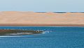
Banc d'Arguin National Park
The National park is on the Atlantic coast Mauritania between Nouakchott and Nouadhibou and was expelled in 1976. Since 1989 he has been a UNESCO Listed world natural heritage.[13]
It includes the Arguin sandbank, which is off the coast of Mauritania and with its shallow reefs extends up to 30 nautical miles into the Atlantic. The sandbar was considered to be one of the most dangerous places on the West African coast. Ships generally keep a long distance from this dangerous stretch of coast. Also the37 Arguin Island![]()
![]()
![]() in the north and several smaller islands, such as the two Kiaone Islands,38 Kiaone West and39 Kiaone East in the south.
in the north and several smaller islands, such as the two Kiaone Islands,38 Kiaone West and39 Kiaone East in the south.

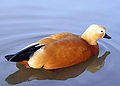
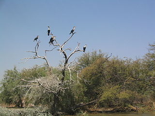
The park is one of the world's most important wintering areas for the whimbrel. In addition, many colony breeders such as greater flamingos, spoonbills, pink pelicans, predatory, king and salmon terns as well as thin-billed gulls breed here.[14]

Whimbrel (Numenius phaeopus)
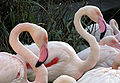
Greater Flamingos (Phoenicopterus roseus)

Spoonbill (Platalea leucorodia)

Pink pelican (Pelecanus onocrotalus)

Predatory tern (Hydroprogne caspia)
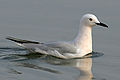
Thin-billed gull (Chroicocephalus genei)


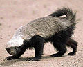
Among the mammals, Dorcas gazelles, golden jackals, fennecs, sand foxes, sand cats, falcons, gorse cats, white-naped weasels, honey badgers and striped hyenas are worth mentioning. At 40 Cap Blanc![]()
![]() (20 ° 46 ′ 16 ″ N.17 ° 2 ′ 55 ″ W.) There is also a small colony of the highly endangered Mediterranean monk seal. The sea is home to several species of turtles and dolphins.
(20 ° 46 ′ 16 ″ N.17 ° 2 ′ 55 ″ W.) There is also a small colony of the highly endangered Mediterranean monk seal. The sea is home to several species of turtles and dolphins.
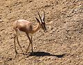
Dorcas Gazelle (Gazella dorcas)

Fennec (Vulpes zerda)

Sand fox (Vulpes rueppellii)
Honey badger (Mellivora capensis)

Dolphin


- 41 Turn off to the village of Bou Lanouar (80 km to Nouadhibou). Bou Lanouar, simple, several auberge, epicerie in the village. Prices disproportionately high.(21 ° 17 ′ 33 ″ N.16 ° 31 '53 "W.)
- Petrol station (only diesel) (2 km after the junction for Bou Lanouar).
- Auberge (45 km to Bou Lanouar). Tents, auberge, food.
- Tree Group (65 km to Bou Lanouar). Small grove.
- Tents with Auberge and Epicerie (95 km to Bou Lanouar).
- Tents with wooden barracks, café, auberge (160 km to Bou Lanouar).
- Tents, restaurant (190 km to Bou Lanouar).
- Barracks (275 km to Bou Lanouar).
- 43 Barracks settlement (290 km to Bou Lanouar). Larger tent and barracks settlement.(19 ° 1 ′ 25 ″ N.16 ° 11 ′ 2 ″ W.)
- 44 Branch to Lemcid (320 km to Bou Lanouar). Junction to Lemcid, 2 km on the right of the road by the sea, simple fishing village, Epicerie.(18 ° 41 ′ 21 ″ N.16 ° 6 ′ 58 ″ W.)
- Slope to the right to the fishing village of Belakahr (340 km to Bou Lanouar).
- Checkpoint. The last 25 km 4-lane road through garbage dumps (365 km to Bou Lanouar).
Nouakchott

45 Nouakchott![]()
![]()
![]() (18 ° 5 ′ 0 ″ N.15 ° 58 ′ 0 ″ W.) (Arabic:نواكشوط, DMG Nawākšūṭ), 390 km to Bou Lanouar, with 1077169 Inhabitants is the capital of Mauritania.
(18 ° 5 ′ 0 ″ N.15 ° 58 ′ 0 ″ W.) (Arabic:نواكشوط, DMG Nawākšūṭ), 390 km to Bou Lanouar, with 1077169 Inhabitants is the capital of Mauritania.
The main artery, Ave Gamal Abdel Nasser, runs through in an east-west direction Nouakchott and ends in the west in the port 6 km away. In the middle of the city it is crossed by the second main street, Ave du Général de Gaulle, that crosses the city in a north-south direction. At the intersection is the tallest building in the city, the ten-story one 46 Hotel and convention center Al-Khaima(18 ° 5 ′ 15 ″ N.15 ° 58 ′ 38 ″ W.) (Arabic "tent"). The business and embassy districts are located on the northern part of Ave du Général de Gaulle. The rest of the city consists of grid-like earth roads.
information
- 47 Honorary Consulate Austria, 10, Rue Mamadou Konaté, Al Khaima City Center, 5th floor (at the Saudi mosque). Tel.: 222 4525 5131, Email: [email protected].
- 12 Main post office, Ave Gamal Abdel Nasser.
- 22 Mauritanian Central Bank (BMCI), Ave Gamal Abdel Nasser.
- 13 State hospital (Center Hospitalier Nationale Sabah), Ave Gamal Abdel Nassar.
Worth seeing
- 48 Friday mosque.large, white mosque with a roof of ten domes.
- 49 Great mosque (Mosquée Saudique)
- 50 Presidential palace
- 51 National Museum. archaeological finds and Moorish folk art.

shop
- 23 Marché Capitale
- 24 Cinquième Marché
accommodation
- 25 Auberge des Nomades, Rue Aliouine Ben Ebi Taleb. simple rooms with breakfast.
- 26 Monotel, Rue Abdoubekr Seddigh. best hotel in town with pool.
- 27 Hotel Adrar, Rue Samba Thiedel M'baye (southeast of the market).
from Nouakchott to Rosso (205 km)
Rosso
14 Rosso![]()
![]()
![]()
![]() (16 ° 30 '46 "N.15 ° 48 ′ 18 ″ W.) (Arabic:روصو, DMG Rūṣū) the third largest city in Mauritania with almost 50,000 inhabitants (as of 2000). Good infrastructure.[15]The main road runs through the town directly to the port. The center is east of the main street.
(16 ° 30 '46 "N.15 ° 48 ′ 18 ″ W.) (Arabic:روصو, DMG Rūṣū) the third largest city in Mauritania with almost 50,000 inhabitants (as of 2000). Good infrastructure.[15]The main road runs through the town directly to the port. The center is east of the main street.

- 28 Hotel Alasmaa (at the northern entrance to the village).
- church (Probably the oldest church in Mauritania) [16]
Mauritania - Senegal border
With independence from France, the border between Mauritania and Senegal was drawn along the Senegal River. Rosso was divided. Auf der mauretanischen Seite versuchen die Zöllner immer wieder Strafen für falsche Visa oder eine Bearbeitungsgebühr für Stempel zu erheben. Auch der Preis für die Fähre über den Senegal ist im Grunde Verhandlungssache. Besser mehr Zeit einplanen und die Argumente ruhig und kreativ ausdiskutieren. Im Allgemeinen gilt auch hier, als Radfahrer wird man weniger als mögliches Opfer gesehen, als als Autofahrer.
von der Grenze nach St. Louis (98 km)
Die Grenzstadt 52 Rosso (Senegal) hat etwa 10.000 Einwohner. Die wohl einzige Unterkunft ist die 29 Auberge le Wallo nahe des Hafens auf der Hauptstraße. Etwas weiter entlang der Hauptstraße befindet sich die 19 Gare Routière.
Abstecher nach Richard Toll
6 km nach Rosso kommt linkerhand die Abzweigung nach 53 Richard Toll![]()
![]()
![]() (16° 28′ 0″ N15° 41′ 15″ W), das man in weiteren 13 km erreicht. Richard Toll hat etwa 70.000 Einwohner und ist vor allem für die Zuckerrohrverarbeitung bekannt.
(16° 28′ 0″ N15° 41′ 15″ W), das man in weiteren 13 km erreicht. Richard Toll hat etwa 70.000 Einwohner und ist vor allem für die Zuckerrohrverarbeitung bekannt.

- mit 11.000 Einwohnern die erste größere Stadt im Senegal.
- 55 Tilène(16° 16′ 0″ N16° 10′ 59″ W)
- 56 Ndiongo(16° 13′ 2″ N16° 14′ 44″ W)
- 57 Lampsar(16° 6′ 31″ N16° 21′ 4″ W)
Saint Louis
.JPG/220px-Saint-Louis_du_Senegal_-_Rue_(2).JPG)
58 Saint Louis![]()
![]()
![]()
![]() Saint Louis, seit 2000 UNESCO Weltkulturerbe, hat etwa 176000 Einwohner. Das Zentrum der Stadt liegt auf der Insel Ile de N'Dar, welche über die 500 m lange Pont Faidherbe mit dem Festland verbunden ist. Über eine weitere Brücke, Pont Mustapha Malick Gaye, erreicht man die Halbinsel 59 Langue de Barbarie
Saint Louis, seit 2000 UNESCO Weltkulturerbe, hat etwa 176000 Einwohner. Das Zentrum der Stadt liegt auf der Insel Ile de N'Dar, welche über die 500 m lange Pont Faidherbe mit dem Festland verbunden ist. Über eine weitere Brücke, Pont Mustapha Malick Gaye, erreicht man die Halbinsel 59 Langue de Barbarie![]()
![]()
![]()
![]() .
.


Festland
- 20 Central Station
Ile de N'Dar
- 15 post
- 16 Tourist Information
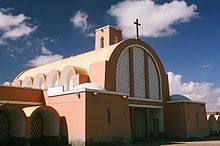
- 60 cathedral
- 25 Banque Internationale Pour le Commerce et l'Industrie du Senegal, Rue Blanchot.
- 30 Auberge de Jeunesse L'Atlantide, Ave Jean Mermoz.
Langue de Barbarie
- 26 Marché Ndar
security
The area of Westsahara, im Dreieck der völkerrechtlich umstrittenen Demokratischen Arabischen Republik Sahara, Mauritania and Algeria ist immer wieder Spannungen ausgesetzt. Genaue und aktuelle Informationen sind vor der Reise unbedingt zu recherchieren. Siehe dazu auch die entsprechenden Länderinformationen.
Morocco
Marokko ist ein recht sicheres und sehr freundliches Reiseland. Wie überall sind es gerade die Großstädte, vor allem Agadir, in denen man eine gewisse Vorsicht walten lassen sollte. Taschendiebstähle kommen vor, vor allem, wenn man seine Sachen unbeaufsichtigt lässt. Bewaffnete Überfälle sind selten.
Auch die Checkpoints in der Westsahara passiert man in der Regel ohne Schwierigkeiten. Eventuell wird versucht mit fantasievollen Argumenten Bußgelder für fehlende Genehmigungen oder Bearbeitungsgebühren einzufordern. Meist lässt sich das genauso fantasievoll ausdiskutieren. Wichtig dabei ist den Stolz der Araber nicht zu unterschätzen. Man sollte seinem Gegenüber immer einen Ausweg in der Argumentation lassen, bei der er sein Ansehen waren kann.
Marokko ist ein muslimisches Land und der Glauben dringt viel tiefer in den Alltag, als bei uns in Europa. Die religiösen Sitten sollte man unbedingt beachten. Man wird als Andersgläubiger jedoch in Marokko mit Respekt behandelt. Das trifft vor allem im Ramadan zu. Während die meisten Marokkaner fasten, sind Kranke, Junge und Alte, Schwangere, genauso wie Reisende davon ausgenommen.[17]
Mauritania
Die Kriminalität spielt sich auch hier vor allem in den größeren Städten ab. Vor allem am Strand von Nouakchott kommt es immer wieder zu teils gewalttätigen Überfällen.Alkohol ist in Mauretanien nur schwer zu bekommen und wenn zu abenteuerlichen Preisen.
taking photos
Die Wüste ist eine atemberaubende Bühne für Fotografen. Die Einwohner sehen das etwas anders. Die Marokkaner und Mauretanier lassen sich nicht gerne fotografieren. Man sollte vorher höflich fragen. Dies gilt insbesondere für Portraits von Frauen. Bei allem, was nur im entferntesten militärisch interessant sein könnte sollte man sehr vorsichtig sein. Das betrifft vor allem Brücken, Checkpoints aber auch größere Straßenkreuzungen und das vor allem im Gebiet der Westsahara. Schnell muß man sich sonst unangenehme Fragen stellen lassen.
Minen, UXO
Das von Marokko besetzte Gebiet der Westsahara wird durch den Berm genannten Wall vom Gebiet der Polisario getrennt. Schätzungen zufolge befindet sich entlang des Berm die weltweit höchste Minendichte[18]. Derzeit arbeiten sowohl die marokkanische Armee, die Polisario und die UNO daran, Minen und UXO (unexploded ordinance, dt. Blindgänger) zu markieren und zu entfernen.[19]
Entlang der Hauptrouten sollte das Risiko sehr gering sein. Vorsicht jedoch abseits der Straße und v.a. im Grenzbereich Marokko-Mauretanien. 2015 gab es Überschwemmungen im Bereich der Westsahara. Seither besteht wieder erhöhte Gefahr durch fortgespülte Minen.[20]
Visum
Siehe jeweilige Länder zu den aktuellen Informationen und unter Web links.
miscellaneous
Such- und Rettungsaktionen in abgelegenen Regionen werden mit genauen GPS Daten erleichtert. Satelitengestütze GPS-Tracker bieten Alarm-Funktionen für Notfälle und sind heutzutage kostengünstig und handlich.[21]
trips
- The 61 Nationalpark Djoudj liegt 60 km nordöstlich von Saint Louis im Mündungsgebiet des Senegalflusses. Seit 1981 gehört das drittgrößte Vogelreservat der Erde zum Weltnaturerbe der Unesco
- The 62 Nationalpark Saloum Delta befindet sich 200 km südlich von Saint Louis.
- Von Saint Louis sind es 260 km über die N2 bis in die Hauptstadt 13 Dakar
 .
.


literature
travel Guide
- : West Africa. London: Rough Guide Ltd, 1999 (3. Auflage), ISBN 1-85828-468-6 (eng).
- : The Rough Guide to Morocco. Rough Guides, 2010, ISBN 1848364776 (eng).
- : Morocco. Victoria, Australien: Lonely Planet Publications, 2007 (8. Auflage), ISBN 978-1-74059-974-0 (eng).
- : Fahrrad Weltführer. Germany: Reise-Know-How Verlag, 1993, ISBN 3-9800975-8-7 .
Karten
- Michelin - Nationalkarte Nordwest-Afrika (741). Scale: 1:4.000.000. Michelin Editions des Voyages. Trotz ihres großen Maßstabes erstaunlich genaue Karte.
- Michelin - Marokko (959). Scale: 1:800.000. Michelin Editions des Voyages.
- Open Street Map (https://www.openstreetmap.org/)
Weiteres
- : Wildnis-Küche. Bielefeld: Reise-Know-How Verlag, 2002 (3. Auflage), ISBN 3-8317-1077-5 .
- : Healthy Travel - Africa. Victoria, Australien: Lonely Planet Publications, 2000, ISBN 1-86450-050-6 (eng).
- : Orientierung mit Karte, Kompass, GPS: Grundwissen-Verfahren-Übungen. Herford: Busse und Seewald, 1998 (9., überarbeitete und erweiterte), ISBN 3-512-03184-6 .
- : Gesichter der Erde, Weltvademecum, geographisches Hand- und Lesebuch für Reise, Schule und erdkundliche Weiterbildung. Hanover: Touristbuch, 1999 (3., völlig neu bearbeitete, aktualisierte und stark erweiterte), ISBN 3-924415-23-4 .
Web links
credentials
- ↑Horst Eichler: Gesichter der Erde, Weltvademecum 1999
- ↑https://www.water-for-africa.org/de/wasserverbrauch.html
- ↑http://whqlibdoc.who.int/publications/2005/9241593180.pdf
- ↑http://rehydrate.org/Homemade
- ↑https://www.fahrradmanufaktur.de
- ↑Helmut Hermann: Fahrrad Weltführer in Kapitel 2 Rad und Ausrüstung
- ↑http://www.jeuneafrique.com/289380/economie/infrastructures-les-projets-les-plus-marquants-de-lannee/
- ↑http://whc.unesco.org/fr/listesindicatives/1182/
- ↑ 9,09,1http://ma.chm-cbd.net/manag_cons/esp_prot/stat_nat/parc_nat/pn_khenifiss
- ↑http://www.naufragio.org/
- ↑https://bhpbillitonwatch.net/2010/11/15/western-sahara-bou-craa-phosphate-mine/
- ↑http://worldaerodata.com/wad.cgi?id=MR06586&sch=GQPP
- ↑http://whc.unesco.org/en/list/506
- ↑http://www.birdlife.org/datazone/sitefactsheet.php?id=6629
- ↑w:en:Rosso
- ↑Letter from Mauritania, abgerufen am 20. Juni 2016
- ↑Koran: Sure 2, am Ende des Verses 185
- ↑http://www.the-monitor.org/en-gb/reports/2016/western-sahara/mine-action.aspx
- ↑http://www.mineaction.org/programmes/westernsahara
- ↑http://www.icbl.org/en-gb/news-and-events/news/2015/floods-intesify-landmine-threat-in-western-sahara.aspx
- ↑https://www.findmespot.eu/gm/index.php?cid=102