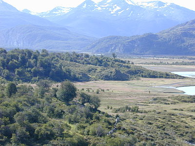
The Región de Magallanes y de la Antártica Chilena is the southernmost region of Chile. It is cut off from the rest of the country and consists mainly of islands and an elongated glacier area, the Campo de Hielo Sur, with the famous national park Torres del Paine.
The wildness of nature and the scenic attractions make up the charm of the remote, cold region, in which the 20 degree mark is rarely exceeded even in midsummer.
Regions

places

- 1 Punta Arenas


 in the Wikidata database") , 150,000 inhabitants, capital and southernmost major city in the world. Hardly any architectural attractions, but all the more scenic.
, 150,000 inhabitants, capital and southernmost major city in the world. Hardly any architectural attractions, but all the more scenic. - 2 Puerto Natales, 20,000 inhabitants, near the Torres del Paine National Park in the northwest of the area.
- 3 Porvenir, 7,000 inhabitants, the only town of any importance in Tierra del Fuego
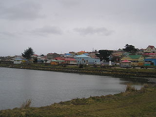
- 4 Puerto Williams, 5,000 inhabitants, southernmost city in the world, on Navarino Island on the Beagle Channel
- 5 Cerro Sombrero, 1,500 inhabitants, on Tierra del Fuego
- 6 Fuerte Bulnes, southernmost place on the mainland
- 7 Puerto Edén, the only place in the north of the area, settlement of the Kawesqar Indians, only accessible by ferry from Puerto Montt


Other goals
- 1 Bernardo O'Higgins National Park, in the north, hard-to-reach glacier landscape
- 2 Torres del Paine near Puerto Natales, with glaciers and strange, extremely steep granite mountains
- 3 Alberto de Agostini National Park
- 4 Isla Magdalena National Park, the big island west of Puerto Cisnes is almost completely under nature protection, 157,615 hectares
- 5 Cabo de Hornos National Park, at Cape Horn
- 6 Pali Aike National Park
- 7 Cueva del Milodón, Cave in which a prehistoric mammal (the Mylodon, a sloth up to 4 m tall) was found at Puerto Natales.


background
.jpg/350px-Puerto_Williams_(Vue_du_Beagle).jpg)
The region is an area of records: both the southernmost point of the American mainland (Peninsula Brunswick South from Punta Arenas), the southernmost point of America at all (Diego Ramirez Islands - However, it is controversial whether those located slightly further south South Sandwich Islands still belong to America), the southernmost city (Punta Arenas) and the southernmost city (Puerto Williams) of the world. In the south of the area is also the notorious Cape Horn.
Since Chile is also part of the Antarctic claimed, that is Chilean Antarctic Territory incorporated into this region on Chilean maps. This is not to be confused with the province Antártica Chilenawhich also includes the south of Tierra del Fuego (Navarino Island to Cape Horn) and which is undisputedly part of Chile.
language
In the north there are still a few Mapudungun speakers among the Araukans, but their settlement center is further north. Otherwise, normal Chilean Spanish is spoken with a weak local touch. The languages of Tierra del Fuego are considered to be extinct, the Kawesqar of the islanders around Puerto Edén is under threat.
getting there

We recommend arriving by air. The airport Punta Arenas is also the hub of the southern tip of South America.
The only way to get there by land is via Argentina possible. A bus (e.g. from Mendoza Near Santiago) to Río Gallegos be taken and transferred there. There are lines from Río Gallegos to Puerto Natales and Punta Arenas, where you turn to Tierra del Fuego (Porvenir) and the Navarino Island by passenger ferry (Puerto Williams) can change.
Traveling by ferry from is an adventure Puerto Montt which is reasonably expensive (US $ 390 / person upwards, as of 2008), but because of the extremely natural fjord landscape of the Bernardo O'Higgins National Park with its glaciers. Description and prices (English)
mobility
There are bus and air connections between the larger towns in the area. The regional airline Aerovías DAP also serves smaller places.
Tourist Attractions

- Torres del Paine. Mountain formation in the national park of the same name.
activities
Hiking and trekking is possible in almost the entire region, with the exception of a few islands, which are a strict reserve, and private properties. Boat trips to the fjords of the area are often offered.
kitchen
nightlife
There is a decent nightlife in Punta Arenas and Puerto Natales. Otherwise, the nights in the region are calm and, with a little luck, clear stars.
security
The region is politically highly isolated, which makes it very difficult for criminals. That's why you don't need to be afraid in the region for life, your belongings and goods. Nevertheless, a certain basic caution is required, especially in the tourist centers.
climate
Off the coast to the west, the climate is very humid and rainy. South of the Campo de Hielo Sur cold to cool weather is to be expected all year round (15 ° C on average during the day in midsummer), even if no extreme frosts are recorded.