 | ||
| Sarntal | ||
| region | Trentino-South Tyrol | |
|---|---|---|
| Residents | 7.098 (2018) | |
| height | 961 m | |
| Tourist information Tel | 39 0471 623091 | |
| no tourist info on Wikidata: | ||
| location | ||
| ||

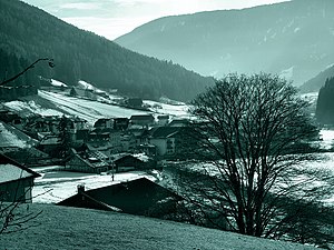
The Sarntal with its side valleys is the central valley system in the Sarntal Alps in South-Tirol. The region markets itself as that Heart of South Tyrol.
Regions
The stream of the Talfer drains the valley system from north to south. The brook has its headwaters at the Penserjoch at 2,211 m and flows into the Eisack after a length of approx. 46 km in Bozen at approx. 260 m height.
That gives it its name Sarntal, the gorge-like and deeply cut part of the valley system of the Talfer Bach (Sarner Gorge) in the southern lower part.

Up the valley at Branch field behind Sarnthein the branches to the west Durnholzertal ab, the valley of the Talfer Bach on the east side is now called Penser Valley. Penser Tal and Durnholzer Tal are more extensive valley valleys.
- Side valleys of the Pensertal are :
- Sagbach Valley with Sagbach;
- Side valleys of the Durnholzertal are:
- Seebbachtal with Seebbach;
- Grossalmtal with Großalmbach;
- Plattental with Plattenbach;
- Gedrum Valley with Gedrumbach;
places
The towns and hamlets in the Sarntal together form the political municipality Sarntal, it consists of a total of 10 places and 17 other fractions with a total of approx. With an area of 302 km², Sarntal is the largest municipality and in terms of population the eighth largest municipality in South Tyrol. The place Sarnthein is referred to as "the village".
The Factions the municipality of Sarntal are: Aberstückl, Agratsberg, Astfeld, Sarnthein-Dorf, Dick, Auen, Ausserpens, Durnholz, Gentersberg, Essenberg, Gebracksberg, Innerpens, Glern, Muls, Kandelsberg, Niederwangen, Nordheim, Öttenbach, Putzen, Rabenstein, Reinswald, Riedelsberg , Unterreinswald, Steet, Trienbach, Vormeswald, Windlahn, Weissenbach, some of which are to be classified as hamlets.
in the Sarntal:

- 1 Sarnthein (Ital .: Sarentino), capital in the mountains, with the two places Nordheim and Astfeld (Italian Campolasta and Italian Villa);
- Jenesien (Italian: S. Genesio);
in the Durnholzertal:
- 2 Reinswald with ski area;
- 3 Thornwood with Durnholzersee;
in the Pensertal:
- 6 Pens
Other goals
background

The first evidence of the settlement history of the Sarntal are hunter resting places from the Stone Age. The valley was probably settled via the mountain yokes to the side Etschtal and Eisack Valley and not from the south from the room Bolzano through the Sarner Gorge, which was largely inaccessible until modern times and when the road was built. A place was first mentioned in a document in 1142.
Since the valley was almost inaccessible for a long time in winter, cultural assets and customs, places and farms have been preserved in a more genuine way up to modern times than in the immediately neighboring regions of South Tyrol.
The Sarntal is still predominantly agricultural today with cattle breeding, dairy farming and a few handicraft businesses. Towards the end of the last century, the former mule track from Bolzano was made winter-proof as an access road through the Sarntal Gorge with a large number of tunnels. As a result, some industry has settled in the lower valley area. There is also increasing tourism in summer and winter.

The Sarntal is known for its traditional Handicrafts such as hand weaving, basket making, “Reggele” makers (pipe carvers) or woodturning and in particular the local ones Quill embroidery: Leather goods are embroidered with thinly split strips made from the quills of Indian peacock feathers. The patterns used are usually several generations old. With the rediscovery of country house fashion and folklore fashion in modern times, the few remaining Sarner quill stickers are booming all year round, but handcrafted utensils such as purses, glasses cases or even traditional clothing have their price. In the past it was cheaper because every farm had its own peacock. These vigilant animals give quite loud screams when a stranger approaches their territory.
Sarner costume

The elaborate Sarner costume is called “Bavarian” and is one of the most beautiful costumes in the German-speaking world, the ornate decorations of the quill embroidery are reflected here:
- Marks for the colorful and detailed Women's costume are the hand-embroidered bodices with color changes according to the seasons, valuable silk aprons and lavishly embroidered shoes.
- Features of the Male costume are the tight trousers made of tumbled loden, quill-embroidered waist belts, the "Fatsch", and also embroidered leather suspenders, the "Krax". The headgear represents the marital status: single men wear the black hat with a red ribbon, married men with a green ribbon. Further details are brass buttons or the Reggl, the Sarner pipe.
- The Sarnar Janggar (Trachtenjanker) is made of pure sheep's wool and comes from the Sarntal, it is part of the Sarner Trachten. The real Jangger is knitted very tightly with a left / left pattern and trimmed with real stag horn buttons, today it is a modern item of clothing again.
Wearing traditional costumes on Sundays and public holidays and occasionally also on working days is still the usual custom in the Sarntal, but traditional costume groups from Sarntal can also be found far away Munich on the occasion of the Oktoberfest at Costume and Riflemen to be admired.
language
getting there
In the street
- Of north or south via the Innsbruck-Brenner-Brixen-Bozen-Trient motorway (A 13 - Brenner motorway, in Italy A 22) to Bolzano, from here to the Sarntal.
- in the summer Access to the Sarntal valley is also possible from the north via the Penser Joch (2211m, closed in winter) Sterzing possible.
By train
There is no train connection in the Sarntal itself.
The next train stations are in Sterzing and Bolzano, they are a station for Intercity and Eurocity trains (train timetables under www.trenitalia.com).
By plane
The nearest airport is that of Bolzano (www.abd-airport.it), other airports are located in Verona, in innsbruck (approx. 2 hours by car) and in Munich (approx. 3-4 hours by car).
mobility
During the day there is a regular bus service from Bozen (bus route 150) to the Sarntal and via Sarnthein to Durnholz, approx. Every hour. Info local transport companies in South Tyrol: www.sii.bz.it;
Tourist Attractions

Churches
numerous churches and chapels in the entire valley area:
- church St. Valentin am Gentersberg by S Branch field, probably the oldest church building in the Sarntal, originated in the middle of the 12th century.
- chapel St. Johann im Walde in the Pensertal, created around 1530;
activities
summer
- Horseshoe tour marked high path through the whole mountain range, see Sarntal Alps;
- Legend trail in Aberstückl;
- Outdoor swimming pool please refer Sarnthein;
- horse riding: various riding stables in the valley, Haflinger horses;
winter
kitchen
nightlife
security
- Avalanche and weather report. Tel.: 39 0471 271 177, 39 0471 270 555.
Practical advice
- Sarntal Tourist Office, Europastraße 15, 39058 Sarnthein. Tel.: 39 0471 623091, Fax: 39 0471 622350, Email: [email protected].
- There is a gas station in Branch field;
- See also the article Rockclimbing, it also contains information on the topic Mountain hiking;
climate
The climate of the Sarntal ranges from the sub-Mediterranean zone of a mild and protected alpine valley (wine and fruit are grown in the Sarner Gorge near Bolzano) to extreme locations in the high alpine areas above 2000 m altitude on the Penser Joch (2211 m);
literature
- Sarntal cooperative for regional development and further education (Ed.): The Sarner costume. Vienna: Folio, 2010, ISBN 978-3852565637 ; 128 pages.
cards
- Sarntal Alps, winter hiking map: ski tours, snowshoe hikes, winter hiking trails, cross-country ski trails (M = 1:33 000). Eppan: mapgraphic, ISBN 88-86102-30-5 .
- compass Sheet 056: Sarntal Alps, (1: 25,000, hiking / cycling / ski touring);
Web links
- http://www.comune.sarentino.bz.it - Official website of Sarntal
- Tourism association South Tyrol's south: www.suedtirols-sueden.info;