| Sognefjord Sognefjorden | |
 | |
Location  | |
| Area type | Sea |
|---|---|
| State | Norway |
| Region | Sogn og Fjordane |
Sognefjord is located in Norway.
To know
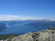
The Sognefjorden is the longest fjord in Europe and the second longest in the world after Scoresby Sund in Greenland. The fjord stretches for more than 200 km from the rugged islands of the North Sea to the high mountains of the hundred. With the many branches the entire Sognefjord system has a coastline of at least 500 km, more than the whole French Riviera.
It is also the second deepest fjord in the world, more than 1000 meters deep. This means that the depth of the Sognefjord without water can be compared to that of the Grand Canyon ofArizona. Although there are wider and deeper fjords in Greenland and Antarctica, this is the only fjord of this size with significant stable settlement and easy access by road or public transport. In fact, two of Norway's main roads, the E16 (Oslo-Bergen) and the E39 (Bergen-Trondheim) run along or across the fjord.
The Sognefjorden is more than a single fjord, it is a large system of fjords. Each branch (arm) of the Sognefjord is a large fjord in its own right and with its own name. The steep mountains rise directly from the water leaving little room for roads and settlements, except in deep valleys such as the Lærdal Valley and the Valley of Flåm. These river valleys are surprisingly flat and offer excellent soil for agriculture. This complex topography makes ground transportation challenging but highly rewarding in terms of scenery.
Geographical notes
It is located near one of the main cities of the country, Bergen. Tourism is very active during the summer, while in the winter everything is covered with snow. Its mountains are home to the glacier of Jostedalsbreen, the largest in Europe on land, with an area of 487 km2. In addition to the glacier there is the Jotunheim National Park, located between various high mountains like lo Store Skagastølstind, (2,405 m). There are also numerous waterfalls, for example that Årdal, 275 m.
Territories and tourist destinations
Characteristic of the towns of the Sognefjord are the wooden churches, such as those of Borgrund, Vik is Kaupanger, all dating back to the 11th-12th century. Among the important churches we should mention that of Luster, included in the World Heritage List ofUNESCO, and that of Undredal, the smallest in Scandinavia.

Urban centers
How to get

By plane
The nearest airports are located at:
By car
- High speed catamaran services several times a day from Bergen.
- Hurtigruten stops at Florø (near the mouth of the Sognefjord) and Bergen.
On the train
Station of Flåm.
By bus
Long distance bus services connect Sogndal with Lillehammer, Lom, Oslo and Bergen. The Sognefjord outdoor area is connected by long distance buses to Ålesund, Trondheim and Bergen.
How to get around
The main fjord is too deep and wide to be crossed by conventional bridges. There are 3 main ferry crossings for each of the 3 main roads: E39, road 13 and road 5. Basically it is not possible to travel north-south except by ferry, although in summer it is possible to get around the fjord via a mountain through the Jotunheimen.
What see
- 1 Fjærland (Route 5 or boat from Balestrand). The Norwegian Glacier Museum and Ulltveit-Moe climate center in Fjærland offer interactive exhibits and glacier films and more. The glacier is visible near the road (an arm of the main glacier). In Fjærland you can also visit the Norwegian book city.
- 2 Jostedalsbreen Glacier Visitor Center (Jostedalen Valley). Breheimsenteret is the information center for the glacier national park. Enjoy the breathtaking view of the Nigardsbreen from the restaurant. This is also an outdoor activity center. This is located in the Jostedalen valley.
- 3 Urnes Stave Church (Urnes: 30 km from Skjolden on the FV331 route, or by ferry from Solvorn), ☎ 47 57678840, fax: 47 57678889, @[email protected].
 Adults: kr 80, students / children: kr 60.
  May 5 - September 30: 10: 30-17: 45. The oldest wooden church in Norway, built around 1130 AD. Included in the world heritage list of UNESCO.

- 4 Borgund Stave Church (Borgund), ☎ 47 57668109, fax: 47 57668108, @[email protected]. Adults: kr 80, students / children: kr 60.. 1st May - 30th September: 10 am-5pm; 11 June - 21 August: 8 am-8pm. Built around 1180. It is the best preserved wooden church in Norway.
- 5 Hopperstad Stave Church (2 km from Vik village). Built around 1140 or earlier, one of the most elaborate of the old Norwegian wooden churches. The building is owned and maintained by the National Trust of Norway.
- 6 Hove Church (Vik). This small but massive Romanesque building is one of the 3 churches in the village of Vik. It was unusual for such a small village to keep 3 churches and brick churches were unusual in rural areas, so the church was supposedly built by a wealthy local lord. It is one of the oldest brick churches in Norway and possibly the oldest in the Sognefjord area.
- 7 Gulating (Eivindvik). The gulating was the legislative assembly of the Viking era and the high court (þing) of western Norway. The site had a central position along the shipping routes. The assembly may have been founded by Harald Hairfair around the year 900 and was in operation until 1300. The Gulating law is the oldest known legislation in Norway. Originally Gulating was a "common assembly" where all the "free men" gathered for the annual meeting, later only the delegates from each district. Around the year 1300 the assembly met in Bergen instead of Gulen. Today the name is kept in the Gulating Court of Appeal in Bergen. Two ancient stone crosses mark the original site, and the new monument marks a later site nearby. Similar assemblies and laws existed for Trøndelag and eastern Norway. When the modern constitution of Norway was drawn up in 1814, the name Storting (great assembly) was adopted.
What to do

- 1 Flåmsbana Railway (From Flåm to Myrdal), ☎ 47 57632100, @[email protected]. It is the third steepest railway in the world. The route, which takes place along the narrow Flåm valley, is constantly rising from 2 m a.s.l. of the homonymous town up to 865.5 m of Myrdal, a railway station of Bergen. The slope varies from 28 per thousand up to 55 per thousand, without the use of a rack for the entire 20.2 km route. To ensure transport safety, the trains are equipped with 5 types of brakes. The drive has been electric since 1944.
- 2 Aurland mountain road (Aurlandsfjellet), Aurland-Lærdal. free. only in summer. This road climbs the steep hills to the mountain pass (1300 meters) between the villages of Aurland and Lærdal. Replaced by a tunnel in 2000 (the longest in the world!) It has nevertheless been retained as one of Norway's national tourist routes. Magnificent panorama. Snow can fall even in summer.
- 3 Lærdal Tunnel (Lærdalstunnelen), Aurland-Lærdal (E16). free. Longest road tunnel in the world (24.51 km long!). To prevent fatigue and boredom of motorists, illuminated caves have been excavated inside.
- 4 Norwegian Center for Wild Salmon, Lærdal village (Road 5 / E16). Learn everything about salmon and the traditions associated with salmon fishing. There are interesting exhibits, exciting films, and a salmon observatory. The Lærdal River is King Harald's favorite salmon river.
- 5 Sognefjellet pass (Sognefjellsvegen), Road 55 from Skjolden. free. only in summer. Norway's highest mountain pass runs through the mountains in Jotunheimen overlooking the peaks and glaciers. The road is closed in winter, it opens towards May. Steep ascent and descent, tight hairpin bends. Cross-country skiing is possible until June.
- 6 Vikafjellet pass, Road 13 Vik-Voss (From Vik to the Sognefjord or from the Vinje interchange in the Voss district). free. Main road 13 crosses the Vikafjellet mountain pass with wonderful views to the village of Vik and the Sognefjord. Occasionally closed in winter. Snow remains on the road until mid-summer.
- 7 Nærøydalen and Nærøyfjorden, Road E16 Voss-Gudvangen (Car or bus). All year round (only during the navigation period). The E16 main road runs through the wild Nærøydalen valley with incredibly steep rock faces and some of the highest waterfalls in the world, at Gudvangen the valley joins the landscape of the fjords of Nærøyfjorden, heritage ofUNESCO. Tourist boat on the fjord.
Shopping
Where to eat
Where stay
Safety
The county is one of the safest in Norway. Keep a safe distance from glaciers. Never hike glaciers without a guide and proper equipment. Watch out for the falls. The fjord itself is extremely deep and very cold most of the year.
How to keep in touch
Around
- Bergen, an important tourist port.
Other projects
 Wikipedia contains an entry concerning Sognefjord
 Commons contains images or other files on Sognefjord