 | |
| no picture on Wikidata: | |
| Western New Guinea | |
| no tourist info on Wikidata: | |
| location | |
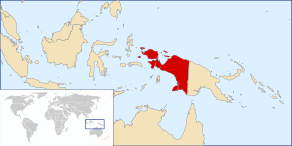 |
Western New Guinea is the Indonesian part of New Guinea. It is separated from the North Moluccas to the west by the Halmahera Sea and from Australia to the south by the Arafura Sea. To the north is the closest inhabited archipelago Palau, a good 800 km away. A dead straight land border too Papua New Guinea exists at 141 degrees in the center of the island.
Regions

Provinces:
- Irian Jaya Barat (West Irian Jaya)
- Papua
colloquially, however, there is no differentiation between this administrative division, which was only made in 2003, Irian Jaya and Papua also applied to the entire region.
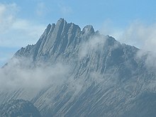
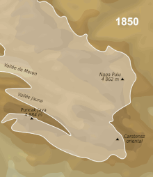
The highest peaks of the Maoke Mountains (“central range”) reach well over 4500 m.
Travel permits
The Surat Jalan, Full name Surat Keterangan Jalan (SKJ), is a travel document that foreign travelers must carry with them when going to areas in the Indonesian provinces of West Papua or Papua that are not approved by the Indonesian government. In practice, this affects most of Papua and areas where the liberation movement is active. The road between Timika and Tembagapura (Freeport-McMoRan concession area) is also a prohibited area. The document is valid for the duration of the traveler's visa. The document can be requested from Polresta-Department located in the administrative offices of the respective residences. The Office in Jayapura issues permits for the entire region, others only for their residency. "Processing fees" for which there is no receipt accelerate the issue.
You should make copies, these will be retained during controls. At the destination you have to report to the police within 24 hours.
Jayapura (and Sentani at the airport), Manokwari and Sorong as well as the island of Biak are always accessible without a permit.
places
- Jayapura largest place and administrative seat.
- Merauke the easternmost city in Indonesia.
- Vogelkopf Peninsula (Semenanjung Doberai) with the locations:
Other goals

- Pulau Biak
- Pulau Yapen (= Japanese)
- Archipelago Raja Ampat, Foreigners pay a hefty 1 million IR (€ 62, March 2019) national park fee for any number of visits within one year.
- Lorentz National Park (Taman Nasional Lorentz; World Natural Heritage), whether SKJs are available to visit depends on the activities of the independence fighters. Tree kangaroos also live here (Dendrolagus sp.). The accessibility via Timika was increased by the expansion of the Mozes Kilangin Airport

 in the Wikidata database") (IATA: TIM) Much improved in 2014.
(IATA: TIM) Much improved in 2014.
.JPG/350px-Mozes_Kilangin_Airport_(Timika).JPG)
Baliem valley
An SKJ is required to travel to the Baliem Valley. Officially there is a ban on alcohol, which has been less strictly controlled for several years. Strangers are not welcome in all villages in the region. You can hire a local guide for hikes. The rainy season is December to February, while June and July are dry. The average temperature is 19 ° C all year round.
There are smaller landing sites that can be reached by chartered small aircraft in the Yali area near Ninia, Angguruk and Kosarek. Korupun in the Kim-Yal region (to the south), Nipsan, Eipomek and Nalca in the Mek region and Langda in Una.
Wamena, the largest town has one Airfield and some accommodations. That’s cheap Guesthouse Hogorasuok with WLAN and communal kitchen, closer to the airfield is the Hotel Nayak (12 rooms). The German-Indonesian one offers real tourist luxury Baliem Valley Resort (2019: single € 100, double € 110, expensive meals, airport transfer € 40.)
The last gaps in the road Wamena ↔ Jayapura should be closed by the end of 2019.
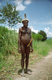
The traditional men's clothing, kotekas, penis quivers, are now being offered for sale on the market (ornate ones are tourist kitsch).
Hikes in the valley are also possible without the numerous imposing guides (if you can do something Bahasa, you can get them much cheaper). Food and gifts should be taken with you, there is usually nothing to buy in the villages. A sleeping bag is also useful for cool nights on the heights.
The landscape is particularly spectacular in the side valleys Wolo and Welesi, but they require a certain amount of effort.
From Warema to Pyramid because Bokondini to Karubaga you should plan one day per stage. The same applies to the path from Wamena, Daelah, Tiom to Karubaga.
After Angguruk in Yalimo you should expect 2, better 3 days brisk, 4-6 days leisurely march.
There are roads into the surrounding area to Nduga, the short distance to Kurima (to the Lani) and Tiom (to the Dali tribe), the last village of which is Kiroma, is a 12-hour march from Kurima. There are two strenuous routes via Gunung Elit, easier but longer via Ninia - which then lead into the territory of the Yali.
In the village of Jiwika, people have set up for a tourist visit because of the 250-year-old mummy named Wim Motok Mabel exhibited there; 100,000 IR are due to visit, overnight stays in a native hut cost just as much. Even when taking photos, 5000 IR are often required per person photographed. The clan chiefs give photo permits for festivities (kepala suku) at a flat rate. (These are practically the only "tourist dollars" paid to the locals.)
background


_with_Ngga_Pulu_(right)_from_Carstensz_Summit_by_Christian_Stangl_flickr.jpg/220px-Sumantri_(center)_with_Ngga_Pulu_(right)_from_Carstensz_Summit_by_Christian_Stangl_flickr.jpg)
The western half of New Guinea became part of the Dutch East Indies under the name Dutch New Guinea. The colonial rulers had little interest in the area, using it as a place for officials transferred to prison, for interning rebels and as a checkpoint on the sea routes to the Spice Islands. The first geological exploration took place in 1907.
Even after Indonesia's independence in 1949/51, Western New Guinea remained under Dutch administration until 1962, when it was initially ceded to Indonesia. The following after the Soehartos coup instigated by the CIA Massacre in Indonesia 1965–66 also took place here, as "communists" to be killed were all those who advocated independence. The Act of Free Choice- The 1969 referendum in which 1020 "trained" electors voted for the continued existence of Indonesian sovereignty, was probably the most obvious electoral manipulation since the Austrian vote for the Anschluss in 1938.
For Indonesians from the main islands, relocation here often amounts to exile or punishment. The effects of the massive resettlement of Javanese poor (transmigrasi) and proselytizing by mainly American fundamentalist-evangelical sects on the cultures of the indigenous population have been devastating in the last fifty years. Today the population is divided equally between indigenous Papuans and half transmigrants, who live mainly in the cities on the coast.
Ruthless exploitation of mineral resources and illegal logging (which is always under the control of corrupt military) as well as plantation management lead to a rapid decline in rich biodiversity due to massive environmental damage.
language

Among the newcomers, especially in the coastal region and in the highlands, hundreds of languages used by only a few thousand tribesmen Papuan family.
getting there
By plane
Inner Indonesian will be Jayapura Airport (DJJ) most frequently flown to.
By boat
Inner Indonesian ferry connections with Pelni there are from Jakarta, Makassar and Surabaya.
The freighter the Perintis / ASDP also serve smaller ports, where the timetable also depends on the freight and must therefore be inquired on site. If you use these ships you should bring provisions with you.
Sailing yachts
For the formalities see in Country article. Those coming from abroad have to redo the paperwork Sorong make. Neither Jayapura nor Raja Ampat are official "ports of entry." There are several reports of break-ins in yachts in 2016-8, especially for Sorong. It is also not possible to issue a “visa on arrival” in this port. (The opening of Jayapura as a “port of entry” was planned for 2018, here would be the visa.) The formalities to be completed are:
- Quarantine (behind the Swiss Bell Hotel) and obtaining the Free pratique.
- Customs, with the quarantine papers, team lists, registration, etc. Copies are no longer necessary, everything is scanned. The ASI's MMSI is required.
- Border police (only 30 days visa-free, or with a full visa)
- possibly you will be sent by customs to the plant quarantine (bioscurity) or harbor master's office.
Note the office hours: 8.0--16.00; Closed for Friday prayers from 12 p.m. to 2 p.m.
In the street
You can get from / to PNG by land via the Skouw / Wutung border crossing.
mobility
With 422,000 km², Western New Guinea is roughly the size of the FRG and Austria combined. Road construction through the jungle in the mountainous interior is difficult, there is no railroad. More remote locations can only be reached by small aircraft, either if there is space in regular supply flights (1-2 times a week) or by charter. The contact person for this is Associated Mission Aviation. Their prices are high, and the runways are mostly in miserable condition.
The 4335 km Trans Papua Highway (Jalan Trans-Papua) should be finally completed in the course of 2019. However, this is not a continuous road, but rather twelve mostly tarred segments that connect some places with each other. These are:
- Jayapura ↔ Sarmi
- Nabire ↔ Waghete ↔ Enarotali
- Merauke ↔ Tanah Merah ↔ Oksibil
- Nduga ↔ Wamena
- Timika ↔ Mapurujaya ↔ Pomako
- Serui ↔ Menawi ↔ Saubeba
- Enarotali ↔ Moanemani (Dogiyai)
- Sorong ↔ Manokwari
- Manokwari ↔ Bintuni
- Fakfak ↔ Hurimber ↔ Bomberay
- Sorong ↔ Mega Moraid
Tourist Attractions
Landscape with rich flora and fauna, under water also in the Raja Ampat archipelago, plus "naked wild animals" in the highlands.
kitchen


In the areas with Transmigrasi population there are the usual dishes, also on the main islands.
The diet of the Papuans living in the highlands is based on what grows, depending on the region and altitude, yams, sago or sweet potatoes are common sources of carbohydrates. Small animals or birds are hunted. Pig farming is widespread among many tribes, their number is a sign of prosperity, they often spend the night on the ground floor of the women's shelters.
Sago Martabak are pancakes made from roasted, then sweetened sago flour. The dish originally comes from the Fak-Fak region.
Another way of preparation is to roast raspberry-like slices.
Papeda is, as the name suggests, sticky sago porridge. It is also eaten in the Moluccas and Celebes. The necessary starch is obtained from the trunk of the sago palm. It is used for storage in tumang called parcels packed from leaves. When preparing it is boiled until the mass thickens. You can get it out of the bowl by holding one of the two chopsticks supplied across it, dipping the second one underneath it and wrapping a lump around the chopsticks, which you quickly put on your plate. It is often served with "yellow soup" made from fish, lime and turmeric. Another side dish is water spinach (tumis kangkung) or papaya flower vegetables (sayur bunga pepaya). Aunu Senebre, a mix of anchovies, taro leaves, and grated coconut is also popular.
Saksak, are sago dumplings, mashed banana, tapioca and sugar are added to the mass. It is then wrapped in banana leaves and steamed.
Ant nests are plants whose tuber is penetrated by labyrinthine corridors similar to those of a termite heap. It is also valued for its healing properties.
Mumu refers to any kind of meat-vegetable-coconut milk mixture that has been wrapped in banana leaves and baked in an earth oven.
Barapen, is an event in which food is prepared in the earth oven, often the meat of a whole pig and vegetables. The effort is only worthwhile on special occasions, not necessarily celebrations, but also often at funeral celebrations.
nightlife
To a lesser extent in Jayapura, where you can also Bintang and get a cocktail in better hotels.
security
Western New Guinea is located in one of the most earthquake-active zones in the world.
There are certainly armed attacks from the Free Papua Movement (OPM) on government agencies, which the Indonesian military responded to with the greatest brutality. As everywhere in Indonesia, "security forces" are less the solution than the problem. Torture and enforced disappearances in custody are the order of the day, as is facilitation payments. One does not expect a fair trial in the country.
climate


On the coast tropical hot and humid all year round, with daytime temperatures of 25-28 ° C, the humid season is March to May. It gets colder depending on the altitude. On some peaks, rapidly shrinking glaciers can be found.
literature
Most Travel guide to Indonesia deal with the region rather briefly.
- Bräuchler, Birgit; Noken: the net pockets of West Papua in the field of tension between local, national and international cultural policy; Neudettelsau 2015 (Pacific Information Point)
- Budi Hernawan; Torture and peacebuilding in Indonesia: the case of Papua; London 2018 (Routledge)
- Heidbüchel, Esther; West Papua Conflict in Indonesia: actors, issues and approaches; Wettenberg 2007 (J&J); ISBN 9783937983103
- Miedema, Jelle; Reesink, Ger P .; One head, many faces: new perspectives on the Bird's Head Peninsula of New Guinea; Leiden 2004 ISBN 906718229X
- Saltford, John; United Nations and the Indonesian Takeover of West Papua, 1962-1969: The Anatomy of a Betrayal; London 1976 (Routledge)
- Tarling, Nicholas; Britain and the West New Guinea dispute: 1949-1962; Lewiston NY 2008 (Edwin Mellen Press); ISBN 9780773450974
- Temple, Philip; Snow over the rainforest: with Heinrich Harrer on the peaks of New Guinea; Munich 2003 (Goldmann); ISBN 3442711940
Maps:
- Indonesia: Papua, Maluku; special maps: Ambon, Haruku, Saparua, Banda Islands, Ternate, Tidore; physical relief mapping, places of interest; Munich 2007 (Nelles), 1 in 1.5 million, 120 ⨉ 50 cm; ISBN 9783865740458
Web links
- West Papua Web (engl.)
