 | ||
| Zams | ||
| federal state | Tyrol | |
|---|---|---|
| Residents | 3.409 (2018) | |
| height | 767 m | |
| Tourist info | 43 (0)5442 65600 www.tirolwest.at | |
| no tourist info on Wikidata: | ||
| location | ||
| ||

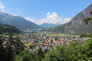
Zams is a village in Upper Inn Valley / North Tyrol and starting point for activities in the surrounding mountains. In winter, Zams can be with a small and family-friendly Ski Area wait up.
background
Zams and Landeck are in the Upper Inn Valley, which is connected here by the confluence of the Sanna from the south Paznaun is widened to a protected valley basin.
The cadastral community of Zams includes the town of Zams with the districts of Lötz, Rease, Oberdorf, Engere, Oberreit, Unterreit, the town of Zammerberg with its districts of Falterschein, Grist, Kronburg, Lahnbach, Rifenal, Schwaighof and Tatschhof and the town of Ausserfern.
The inhabitants of Zams are the Zammer (and not the Zamser).
getting there
| Distances (road km) | |
| Landeck | 3 km |
|---|---|
| Imst | 16 km |
| St. Anton | 28 km |
| innsbruck | 74 km |
| Garmisch | 76 km |
| Munich | 164 km |
| Vienna | 566 km |
The area around Landeck-Zams is an important traffic junction for railway lines and the streets in the Vinschgau, in the Engadine, the Vorarlberg and further into the Lake Constance area and in that Lower Inn Valley.
By plane
The nearest international airports are the Innsbruck Airport (Distance about 69 km, 45 minutes drive) and north of Munich the Munich Airport (also "Franz Josef Strauss", distance approx. 200 km).
By train
The city is on the Arlberg railway line (innsbruck - Bludenz).
The Landeck-Zams train station is the end point for regional trains innsbruck, Station at the Arlbergbahn and as a through station also a stop for all international trains in long-distance traffic Vienna, Salzburg, Bregenz and Zurich.
The train station is between Landeck and Zams and about 2 kilometers west of Zams. Continue by bus, taxi or on foot.
In the street
Zams is on the toll road A12 and coming from the east in front of the Landecker Autobahn tunnel to the Arlberg Schnellstraße S12 to the west Vorarlberg or into the Arlberg area.
To the northeast of Zams at the Oberinntal junction, the Landeck tunnel branches off with the Reschenstraße to the Reschenpass (181).
Directions from west (innsbruck) on the A 12 (Inntal Autobahn) and from eastVorarlberg on the S 16 (Arlbergschnellstraße), exit Zams.
Toll-free routes:
From Germany, the toll-free journey is via the Fernpass route (Munich - Garmisch - Imst) and from Imst still possible for around 17 km via the busy road (B 171, Tiroler Bundesstraße) to Zams.
On foot
Zams is a stage on the European long-distance hiking trail E5.
mobility
Tourist Attractions
- The completely free-standing one 1 Tower of the Zammer Parish church dates back to the new building and renovation with consecration in 1698 and is the landmark for Zams. The rest of the church building belonging to this was destroyed in a local fire in 1911. The new 2 Church building was newly built approx. 50 m away and was inaugurated in 1913
- 1 Zammer perforated plaster, Römerweg 21, A-6511 Zams (in Lötz northwest of the town center.). Tel.: 43 (0)5442 65600. . Lötzlklamm with climbs and caves, waterfall and one of the oldest power plants in Tyrol. Of course there is also one legend.
activities
The surrounding mountains are in the southwest Silvretta, in the north the Lechtal Alps and in the southeast the Ötztal Alps.
Local mountain about Zams is that Venetberg in the Ötztal Alps and located southeast of the village, a popular excursion and hiking destination because of its wide view all around. The ridge of the Venetberg has several peaks, the end of the cable car from Zahms is the summit "Krahberg". The hikes in the summit region are not too difficult.
- 2 Venet Bergbahnen AG, Hauptstrasse 38, 6511 Zams (in the town). Tel.: 43 (0)5442 62663. .
- Mountain railway to the summit of the Venet panoramic mountain southwest of Zams in the Ötztal Alps, that's the northwest end of the Ötztal Alps and also the mountain above the Landeck tunnel.
In summer
In the winter
Alpine skiing
| Surname | phone | Altitude | Σ | ||||||
|---|---|---|---|---|---|---|---|---|---|
| Venet | 43 (0)5442 / 62663-14 | 780 - 2,212 m | 1 | 3 | 3 | 6 | 15 | 1 | 22 km |
The ski area is located on the north-west slope of the Krahberg (Venetberg).
shop
kitchen
- Venet panorama restaurant (on the panoramic mountain Venet, ascent with the Venetbahn). Tel.: 43 (0)5442 64357.
nightlife
accommodation
health
- 1 St. Vincent (public hospital), Sanatoriumstrasse 43, A- 6511 Zams (approx. 500 m northeast of the town center). Tel.: 43 (0)5442 600. St. Vinzenz is the regional hospital for the Tyrolean Oberland (districts Landeck and Imst) with 2 intensive care units (surgical department, internal department).
Practical advice
| Brief information | |
| surface | 125.04 km² |
|---|---|
| Phone code | 05442 |
| Post Code | 6511 |
| Mark | LA |
| Time zone | UTC 1 |
| police | 133 |
| rescue | 144 |
| Mountain rescue | 140 |
- 2 TirolWest tourist office, Hauptplatz 6, A-6511 Zams. Tel.: 43 (0)5442 65600, Fax: 43 (0)5442 6560015.
- Alpine Club - Weather service
- Avalanche warning service for Tyrol
trips
literature
Web links
- http://www.zams.gv.at - Zams official website
- Local history geschichte-tirol.com.
- TirolWest Tourist Association: www.tirolwest.at.