| Etna | |
 | |
Location  | |
| State | Italy |
|---|---|
| Region | Sicily |
| Territory | Catanese |
| Height | 3,330 m a.s.l. |
| Tourism site | |
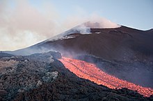
Etna is the mountain that occupies a large part of the Sicily Northern Ionian. The volcanic massif, of vast dimensions, occupies a large part of the Province of Catania . Etna is the highest European volcano and with its 3,330 m. s.l.m. it is the highest peak in Sicily. Etna is part of the world heritage of humanity protected by UNESCO.
To know
This Sicilian volcano is a destination for tourists every year because of the spectacular lava flows that can be observed live.
Mount Etna is a volcanic complex that originated in the Quaternary. Over the millennia, with its eruptions it has contributed to shaping the surrounding area, modifying the landscape and also threatening the populations that inhabit the area. The volcano has also contributed to creating numerous legends both in Greek and Latin mythology and in subsequent eras. The territory is vast and varied: urban areas, wooded areas and vast desolate areas that are subject to lava flows or to become ski slopes during the winter when snow falls. Since 2014 it has been included in the list of assets protected byUNESCO.
Geographical notes

Etna rises on the eastern coast of Sicily, within the territory of the province of Catania and is crossed by the 15th meridian east, which takes its name from it. It occupies an area of 1265 km², with a diameter of over 40 kilometers and a base perimeter of about 135 km.
After it Stromboli, Etna is the most active volcano in Europe and one of the most active in the world. Vapors are often released and eruptions accompanied by lava flows are also frequent.
On the east side, an important reference is the 1 valley of the ox, a large depression filled by lava flows that periodically fill it. The main flows occur in this area as a side of the mountain collapsed and slipped towards the sea around 6000 BC.
The western side is never attacked by the lava flows, as well as the north one. There are not even access roads except to undertake long hiking trails.
The slopes that can be visited, that is, where there are roads leading up to the top, are two. On the north-east side you reach the Piano Provenzana at 1800 m with the homonymous refuge. While on the southern side the Sapienza Refuge at 1923 m.
The currently active craters are the summit ones:
- 2 The Bocca Nuova.
- 3 Northeast crater.
- 4 Southeast crater.
- 5 New Southeast Crater. Currently the most active crater.
Flora and fauna

In 1987 the Etna Park which allows the protection of local flora and fauna. Four zones have therefore been established according to the different degrees of protection.
- Zone A of 19,000 hectares and entirely in the hands of the government. There are no people living there. This part is located in the direct area of volcanic activity and is the domain of large birds of prey such as the golden eagle.
- Zone B of 26,000 hectares. Here are small private plots. The area is characterized by old farms, stone mills, sober houses and the remains of ancient houses. Many small wild animals are hidden here, such as cats and foxes.
- Zones C and D together they reach 14,000 hectares and tourist facilities are prohibited to protect the landscape and nature.
Flora


In the summit area of the volcano there is no type of vegetation as no seeds can germinate on the recent lava. Going down around 2500 meters you will find the soapstone (Sicilian saponaria), the Sicilian astragalus (Astracantha sicula), tansy (Tanacetum siculum), chickweed (Cerastium tomentosum), the senecio (Senecio squalidus), chamomile from Etna (Anthemis aetnensis), rennet from Etna (Galium aetnicum), the rhombus (Rumex scutatus) and some moss and lichen. Already around 2000 meters you can meet, on some slopes, the Bosnian pine, the Etna birch and the beech and even lower down even chestnut and olive trees. Together with this vegetation coexists the Etna broom which with its yellow flowers creates, during the flowering period, a beautiful color with the black of the volcanic lava.
The vineyards of Nerello meet in the hilly area of the slopes, from which the Etna DOC wine of the foothills is produced.
Fauna
On the volcano live the porcupine, the fox, the wild cat, the marten, the rabbit, the hare as well as smaller species including the weasel, the hedgehog, the dormouse, the oak and various species of mouse, bat and snake. Birds and varieties of birds of prey, diurnal, such as the peregrine falcon, the sparrow hawk, the buzzard, the kestrel and the golden eagle, and nocturnal such as barn owl, tawny owl and owl are widespread on all areas of the volcano
When to go
Etna has a specific climate compared to the rest of the Sicily. Up to 1000 m above sea level, the climate is warm and temperate, with little rainfall and minimum temperatures are maintained above 4 ° C, while the temperature can exceed 40 ° C in summer in the lower areas. Above 1000 m the climate is cold, temperate and the rains are abundant. Temperatures drop to -5 ° C in winter and snowfalls that cover the top of the volcano are frequent from November to March each year. The presence of almost permanent strong winds above, gives a perceived temperature down to -10 ° C in winter.
Background

Geological investigations have shown that in 1500 BC a massive eruption occurred. The eruption of 693 BC it was the first eruption recorded in writing. Further eruptions took place in 475, 426-425 and 394 BC. During the Roman era, the main eruptions took place in 350, 141, 135 and 126 BC. The strongest recorded eruption took place in 122 BC. In 44, 38 and 32 BC In a short time, large eruptions occurred which obscured the sky of Rome and caused the disruption of the crops until theEgypt.
| Etna and Fuji |
  Etna (left) and Fuji (right) The Orientalist Fosco Maraini having lived both in Sicily that in Japan compares the two volcanoes with a poetic description, so much so that one brings to mind the other (at least for an Italian). Thus he describes them: "Etna has the air of old age; the Fuji instead it is the image of youth, its lines suggest movement, momentum. Etna is mighty, it makes you think of a wise giant, it is sometimes terrible, but even then it seems to shake its chains with the mysterious inevitability of a nocturnal destiny; the Fuji is agile, proud as a sword, invites you to dare. Etna is profoundly male, it is the patriarch of crops, of villages, of the tuna peoples in the deep waters at its feet; Fuji makes you think of a virgin, not for nothing the beautiful Daughter of the god of the mountains lives there, or of an adolescent warrior who has pure faith in an idea. Therefore Fuji is also close to love and death, to all the great follies; Etna, on the other hand, is time populated by endless shadows. The olive tree, the chestnut tree, the broom are suitable for Etna, plants linked to the fortunes of civilization and the dreams of poets, the vine with the sweet languors it gives to men is also suitable, Etna is always fully of this world ; on the other hand, the wild pines of Ki no kai, of the "Sea of trees" that lambs the north side, and then ashes or snow are suitable for Fuji; Fuji, like poetry, yearns for heaven, you never know for sure whether it belongs to this world or not; "Maybe it's a mysterious kami." |

.jpg/220px-Etna_Volcano_Paroxysmal_Eruption_October_26_2013_-_Creative_Commons_by_gnuckx_(10491854406).jpg)
In 252 and 253 A.D. a 3 km wide lava flow caused great devastation. In 812 and 1169, the eruptions were accompanied by earthquakes and 1,500 people lost their lives. Subsequently, significant eruptions are known in the years 1194, 1197, 1222, 1250 and 1284. Well described eruptions occurred in 1329, 1381, 1408, 1444, 1536, 1537, 1566, 1607, 1610, 1614–24, 1634–38, 1646 –47 and 1651–53. The infamous eruption from 8 May to 11 July 1669 destroyed much of Catania. This eruption is considered to be the largest eruption of our era. Well documented eruptions occurred in 1763 (with the creation of the Montagnola), in 1766 (creating the Calcarazzi Mountains) and to follow: 1780, 1787, 1792-93, 1809, 1811–12, 1819, 1832, 1843, 1852–53, 1865 , 1874, 1879, 1883, 1886 and 1892 (creating the Silvestri Mountains).
In 1908 there was a great eruption in the Valle del Bove, in 1910 and in 1911 with the creation of the Northeast Crater. In 1923 a large part of Linguaglossa was destroyed by a lava flow, in 1928 the eruption caused great devastation, followed by the eruptions of 1942 and 1947. The eruption of 1950-51 is the last major eruption that released 17 million cubic meters of lava . In 1955, an explosive eruption of the northeastern crater occurred which created a slow lava flow that lasted until 1964. The Voragine crater was created in 1964 by a violent eruption of the central crater. In May 1968, the Bocca Nuova was created inside the central crater. From 4 April 1971 to 2 May 1971, a lava flow destroyed the second section of the cable car and the observatory. On March 17, 1981, lava fountains 100 meters high came out from the north side. On March 19, 1981, a lava flow threatened the city of Randazzo. In 1983 a lava flow came south of Nicolosi destroying the Corsaro restaurant. During the eruption of that year, the first attempt was made to divert the course of the lava flow by means of explosives. The eruption from May 1992 to March 30, 1993 was the longest since 1669 and the construction of a protective dam was partially successful albeit a row of houses of Zafferana Etnea were destroyed.
In 2001 and 2002 the cable car and the area around Piano Provenzana were submerged and many buildings were lost. Subsequently, the volcano has repeatedly blocked air traffic to and from Catania. In 2004 and 2005 there were eruptions on the side of the Valle del Bove. In 2006, on the evening of July 15, a crack appeared on the eastern flank of the crater to the southeast and the lava flow flowed into the Valle del Bove until July 24. On November 16, there was again activity around the southeast crater that led to small pyroclastic flows up to 100 meters high. Several eruptions around the southeastern crater spilled into the Valle del Bove between September 2007 and July 2009, and Messina was hit by a wind of volcanic ash. The year 2010 is characterized by a series of small volcanic activities, some with seismic activity. On 25 August, from the Bocca Nuova, a strong explosion generates a cloud of ash about 1 km high. On 22 December there is a strong explosion from the western mouth of the Bocca Nuova, which generates an ash cloud several hundred meters high, causing a light rain of ash to fall on the town of Linguaglossa. Starting from January 2011, Etna still shows a vivid eruptive activity, characterized by intense paroxysmal phases similar to those that occurred in 2000.
The eruptions that took place in 2011 were 18 in total, leading to the formation of a new south-east crater. On 3 December a sudden explosion hits the Bocca Nuova. The eruptive activity of the "New South East Crater" caused the collapse of numerous ash rains on the Etna villages.
Myths and legends

Several myths related to its volcanic nature are associated with the Etna volcano. The giants Enceladus is Typhoon they were confined inside the volcano, and for this reason they are the cause of frequent eruptions. The other associates the fire of the lava with the work of Hephaestus skilled in the art of metalworking with which he forged the weapons of gods and heroes.
According to tradition, the eruption of Etna in 396 BC. - which historically invested and upset the territory acese - he would also have put to flight the Carthaginian fleet commanded by Imilcone which was preparing for a landing during the second Punic war.
Famous is the legend according to which Empedocles in 433 BC he reached the central crater to study it closely by jumping into it.
Territories and tourist destinations

On the contrary, from what one might think, the Etna area is one of the most densely populated in Sicily. In addition to the volcano and its protruding area, the tourist flows are therefore directed towards all the urban destinations of the Etna area, first of all Catania is Taormina.
A useful interactive map showing trails, shelters and points of interest can be viewed here.
Urban centers
Municipalities falling within the Etna Park:
- 1 Adrano - Ancient city of Sicilian origins, now home to an interesting museum and a pretty historic center.
- 2 Belper
- Pallet Town
- 3 Bronte - City famous for pistachio but also a reference for visiting nearby places.
- 4 Castiglione of Sicily
- Giarre
- 5 Linguaglossa - excellent access point to the north side and to the summit craters.
- Maletto
- Mascali
- Milo
- 6 Nicolosi - The city from which most tourists climb Etna towards the Sapienza refuge.
- 7 Pedara - A small town in Etna with a sumptuous mother church.
- Piedimonte Etneo
- Ragalna
- 8 Randazzo - Medieval city bathed by the Alcantara river, an excellent point from which to start exploring the north side of Etna and the nearby Nebrodi and Alcantara parks.
- Sant'Alfio
- Santa Maria di Licodia
- 9 Trecastagni - City full of churches from which you can admire a beautiful view of the Ionian coast.
- Viagrande
- 10 Zafferana Etnea - Known for the centuries-old threat of lava and earthquakes that have tormented it, every year in October it attracts many visitors to the Ottobrata.
Other destinations
How to get
By plane
- 6 Catania airport (Catania Fontanarossa Airport "Vincenzo Bellini"; IATA: CTA), Via Fontanarossa, 20, Fontanarossa, ☎ 39 0957239111.
 00:00-24:00. Airport for national and international flights.

By car
_(4996293393).jpg/220px-Sicilia,_Italia_(NASA_Terra-Modis)_(4996293393).jpg)
The main axis, which runs east of the volcano following the Ionian coast, is the highway ![]() Messina - Catania with exits from north or south: Fiumefreddo of Sicily (north side), Giarre is Acireale (east side), Catania is Misterbianco (south side).
Messina - Catania with exits from north or south: Fiumefreddo of Sicily (north side), Giarre is Acireale (east side), Catania is Misterbianco (south side).
To the south, near Catania, the ![]() is the access road to the volcano and goes into the Sicilian hinterland to join the
is the access road to the volcano and goes into the Sicilian hinterland to join the ![]() which leads to the west side. The latter finally leads to the
which leads to the west side. The latter finally leads to the ![]() which goes around Etna to the north, closing the circle of the road axes that surround the volcano. From these main roads several provincial roads branch off that from the Etna centers go into the slopes of the volcano. All the itineraries are well signposted (also for safety reasons).
which goes around Etna to the north, closing the circle of the road axes that surround the volcano. From these main roads several provincial roads branch off that from the Etna centers go into the slopes of the volcano. All the itineraries are well signposted (also for safety reasons).
The only roads that rise in altitude lead to the two main locations:
- the Wisdom refuge (south side) reachable from Nicolosi through the
 or the "Via Catania", both arrive at the same point as well as from Zafferana Etnea on the east side.
 - Piano Provenzana (north-east side) reachable via the Mareneve road from Fornazzo is Linguaglossa.
- 7 Port of Catania. For those arriving by sea it is very easy to find other means of transport to reach Etna.
On the train

- 8 Circumetnea railway, Via Caronda, 352 / A - 95128 Catania, ☎ 39 095541111, fax: 39 095431022, @[email protected]. Having time and wanting to visit the Etna area in stages with less hectic times, a valid alternative is the Circumetnea railway. The railway leaves, like a subway, from the stop port of the Catania underground and out of the city, it goes all around Etna from the south, west and north, except for the coastal stretch (to the east): a Giarre-Riposto it is exchanged with the FS line Messina-Catania. This solution allows a low cost but must be evaluated with conscience. In fact, if on the one hand the tortuosity of the route allows it to merge with the landscape, gradually less and less urbanized moving away from Catania, in a slow symbiosis, on the other hand the dilation of time and the lack of one's own means require a very precise organization of the itinerary and its times. The trains are those of a local line, with all that derives from this in terms of crowding at peak times of working days in the Catania area, while the more you go west and north, the lower the frequencies. Often the route is interrupted due to modernization works and some sections could be replaced by replacement bus services. Bicycles can also be transported.
 The route of the circumetnea and its stations

By bus
There is one bus a day that leaves from the bus station of Catania (in front of the train station) e Nicolosi (there Gate of Etna) and arrives at Sapienza Refuge which is located about 1,400 meters below the top of the volcano. The AST bus leaves from Catania at 8:15 am and the return ride leaves at 4:30 pm; the round trip cost is € 6.60 and the payment must be made in cash at the AST ticket office.
There are also several agencies that offer guided tours both to the volcano and the surrounding area. Alternatively you can try to contact the Etna Regional Park.
How to get around
By car
On Etna it is the best and most practical way. However, we must consider that during the winter period there is an obligation to have chains on board.
Cable car

- 9 Etna cableway (Next to the Sapienza Refuge), ☎ 39 095 914141, 39 095 914142, @[email protected].
 70 € (jeep cable car). 8:30-16:15. This cable car has been periodically destroyed by eruptions and over time the characteristics of the system and the arrival stations have changed. Starting from Rifugio Sapienza it allows you to reach an altitude of 2,504 m from which you can then continue on foot or by jeep.
By bike
There are many bicycle enthusiasts who face the climb of Etna using the ordinary roads or mountain bike enthusiasts move between the paths and the woods.
On foot
The presence of several paths makes walking almost completely natural.
What see

- 1 Silvestri craters (Sapienza Refuge, behind the Crateri Silvestri restaurant bar). Located at the same altitude as the Sapienza refuge (1,986 m), the silvestri craters are old emission vents now closed. All the tourists who come up to here visit them, both for the suggestion of walking around a crater and for the panorama of the south side that can be enjoyed on fine days.
- 2 , ☎ 39 095 911580. The observatory is active and performs observations of the sky, it is also open to visits. But also a walk in the surrounding area is very pleasant as a part of Etna is fairly wooded.
.JPG/150px-Monte_Sartorius_(37).JPG)
- 3 Sartorius Mountains (on the north-east side, a few hundred meters from the Citelli Refuge). A series of extinct craters characterized by the typical "buttonhole" alignment of the eruptive cones along an old flow of 1865. Their name derives from the scholar Sartorius von Walterhausen, which was among the first to map the most important eruptions of Etna. There are also several hiking trails on volcanic sand.

- 4 Ilice of Carrinu (Ilice di Carlino) (From Zafferana Etnea take a pedestrian path that starts from the Dagalone district, or from a path owned by the Forestry Corps from the Caselle hamlet, in the municipality of Milo). Free. Free use. It is a 700-year-old holm oak tree located at an altitude of 937 m a.s.l. Its name derives from the Latin ilex while Carrinu derives from Carlino, the ancient owner of the estate. Since 1982 it has been part of the Italian heritage of green monuments. It has a height of over 20 meters, a diameter of the fronds of about 30 meters and a circumference at the base of almost 5 meters. Nearby are the ruins of an old lava stone house.

- 5 Chestnut of the Hundred Horses (From Sant’Alfio take the uphill road SP 5i and then turn to the
 . However, there are adequate road signs). Free. Free use. It is a multi-thousand-year-old chestnut tree, in 1982 it became an Italian heritage of green monuments with its 22 m height and trunk perimeter which also made it enter the Guinness Book of Records in terms of size. According to biologists, the tree is between 2,000 and 4,000 years old. The name derives from a legend according to which a queen with her knights was surprised by a storm, and all one hundred knights who were part of the escort put themselves under the tree to shelter.
- The chestnut area is a pleasant place to bring children, due to the presence of merry-go-rounds and public games. But there is ample space for a picnic or lunch at one of the restaurants in the area.

- 6 Monte Zoccolaro (on the eastern side of Etna along the donkey's back). This relief of volcanic origin whose highest point measures 1,739 m. At the top there is a cross relocated in 1978. The mountain is often a destination for excursions as well as a privileged point to see the eruptions on this side.
- 7 Quarantore stream (Sciambro stream). This torrent in spring, ie during the thawing of the snow at high altitude, flows for forty hours, collecting the waters of the summit area of Etna.


- 8 Sanctuary of the Madonna della Sciara, Via Mompilieri, Mascalucia, ☎ 39 095 791 4117. A Catholic sanctuary famous because following the eruption of Etna in 1669 it was destroyed by lava (in fact the foundations of the ancient church are visible) but of which the statue of the Madonna miraculously intact was found long after. In addition to the modern sanctuary and the small church, you can visit the ancient place (now underground) where the church used to be.
- 9 Former Casa Cantoniera (along the
 ). Former Casa Cantoniera destroyed by the lava of the past eruptions of Etna. Only the sloping roof can be seen from the bend today.
 - 10 Botanical Garden of Etna Nuova Gussonea. Mon-Sat 9: 00-12: 30. It is a typological garden extended for about 10 hectares and located at an altitude of 1700-1750 meters on the southern slope of Etna. The garden fully reproduces the environments of Etna's volcanic flora, including special parts, such as small caves dug by lava flows and also contains a seed deposit (Valerio Giacomini refuge) and a small meteorological station for recording climatic data.
- 11 Mount Leporello. Pyroclastic cone that reaches an altitude of 1,734 m. It can be reached thanks to the forest paths in excellent condition in the area.
- 12 Effusive mouths of 1928 (At the Giarrita Forestry Property). These are three craters that arose during the 1928 eruption in the Fosse Santoro area, which are now extinct and can be visited.
- 13 Effusive mouths of 1981.
- 14 Neviera by Don Puddu. This snow cellar built between the late nineteenth and early twentieth centuries takes its name from Mr. Giuseppe Leotta known as Don Puddu. It is a 10x18 meter rectangular structure with a descent where snow was collected during the winter and then covered with a layer of leaves and volcanic dust. During the good season the ice was extracted which was then brought downstream and traded.
Woods

- 15 Forest state property of Giarrita (Access along the Mareneve road). A pleasant wood to visit or cycle or walk, above the municipalities of Sant'Alfio is Piedimonte Etneo.
- 16 Wood of centorbi (On the western slope of the volcano between Bronte is Adrano, to log in use 10 this gate). Wood on the western side of Etna that can be visited in combination withPiano delle Ginestre itinerary.
- 17 Ragabo pine forest (From Linguaglossa along the via Mareneve).
Caves

- 18 Frost cave (Northwestern side in the Randazzo area), ☎ 39 095 234310. The Grotta del Gelo is a cave characterized by having perennial ice inside, for this reason it is considered to be the southernmost glacier in Europe. It is located at an altitude of 2,030 meters above sea level. The cave is 125 m long with a vertical drop of 30 m. Due to its peculiar characteristics it is monitored by speleologists in collaboration with the Etna Park.

- 19 Snow cave, Mareneve Regional Road (From Milo along the via Mareneve). free. 00:00-24:00. This cave was used in the eighteenth century as a deposit for snow taken at high altitude or in the surrounding area. To improve its use, three wells were dug and easy access was created even for the mules onto which the snow blocks were loaded. In 1784 the painter Jean Houel documented the place through the painting "La grotta a la neige" now exhibited at the Hermitage Museum in St.Pietroburgo.
- 20 Monte Corruccio cave. Cavity of the eruptive apparatus of Monte Corruccio. A collapse of the vault separates the cave into two parts. In the final section, the gallery is divided into two levels.
- 21 Cave of the Raspberries (On the north side at an altitude of 1745 m). This cave was discovered in 1965 and takes its name from a raspberry plant present at its entrance at the time. Born from a lava flow of the 1600s, it has a cavity with a semicircular roof that recalls the dammusi. It is 700m long with an elevation gain of 90m.

- 22 Pythagoras cave (Along the donkey's back path at an altitude of 2000 m). It is a small cave at right angles (for this reason the allusion to Pythagoras) formed by a dicco of lava flow.
- 23 Grotto of the College (Snow cave) (On the western side, a short distance from the Bosco di Centorbi). A natural cave used in the past as a snow house, that is, where snow and ice were kept in winter even for the warm seasons. You see Piano delle Ginestre itinerary.
- 24 Pietracannone cave (Next to the pietracannone refuge). It is a small cavity created by the presence of a tree then burned by the lava.
- 25 Serracozzo cave (near the Citelli Refuge). This lock-shaped cave is several meters high and no wider than 3m. In the first section the walls are opaque but later they retain a glassy aspect.
- 26 Cave of the Palombe.
- 27 Cave of the females.
- 28 Schadlish cave.
- 29 Cave of the arches.
- 30 Serracozzo cave (Along the Serracozzo path). This cave has a lock-shaped section with a height of several meters and no wider than 3m. The downstream section is a steeply sloping former lava flow tunnel, 350 m long. In the first section the walls are opaque but further on they have a glassy appearance.
What to do
| To learn more, see: Volcanoes. |
During the eruptions Etna attracts many onlookers. The volcanic activity is very fascinating and many tourists love to organize photographic and video services of the lava fountains or castings. In recent years, eruptions have affected the east side of Etna, with the flows that pour into the Valle del Bove. The points where it is possible to admire the flows are the clearings in the Ionian countries from Taormina to Catania. Those who want to get closer, have to go up in altitude or go on a real excursion. Privileged observation points are located along the donkey's back path.
Excursions

Etna attracts many hikers every year fascinated by the possibility of walking on lava stone paths and wide open fields where the old flows are visible. The landscape is often lunar, depending on the slope and the position and the presence of vegetation and trees is varied. There are real woods but many parts have few trees so apart from the surrounding landscape and relative to the altitude, it is often monotonous.
To better visualize the routes on the WV dynamic map we suggest enabling the following options: hilly reliefs is hiking trails or read the article Paths of Etna in which the paths proposed below are explored.
- 1 Ascent to the central crater (take the cable car from the Sapienza refuge then use the means available or go up on foot). The ascent to the central crater is not a simple thing nor to be taken too lightly. The slopes are considerable, the ground conditions difficult being often slippery. The climatic conditions are always to be taken into consideration.
- 2 Donkey's back trail. Leave the car in the small parking lot and follow the dirt path which in about 45 minutes will lead to a panoramic point near the Bove Valley. The hike could continue further along the ascent trail, but it is necessary to have maps or GPS with you. Along the way you will find the Pythagoras Cave (see above) and for those there is also the 31 Malerba tombstone.

- Path of the Brooms (S.d.G. 7). It winds along the eastern side of Etna along the side of the volcano at a medium height. The path is traced by the Etna Park and indicated but can also be downloaded on GPX file. Given the length it can be done in stages.
- There high mountain track starts from11 entrance of the Galvarina and extends for 42 km along the western side of Etna with a difference in height of 300 meters. The path corresponds to part of the European trail E1. It is also accessible by mountain bike.
- Piano delle Ginestre itinerary - Trekking on the western side between ancient lava flows and the Centorbi wood.
- 3 Monte Nero degli Zappini Nature Trail (Next to Monte Vetore and the Serra la Nave astronomical observatory). Route of 4 kilometers. It does not present any difficulty and is particularly suitable for school groups and groups due to its didactic value.
Guide Service
- 4 Etna north guides, Via Roma, 81/83, Linguaglossa, ☎ 390957774502, 393480125167, @[email protected]. Agency that brings together Etna mountain guides to organize excursions.
- 5 Etna Sicily Touring, Via Giuseppe Verdi, 155, 95129 Catania, ☎ 39 3925090298, @[email protected]. Leading hiking association for the organization of guided excursions at high altitude on the volcano and around Etna.
- Step in Sicily, ☎ 393332041737, 393338090792. Cultural association affiliated with Federescursionismo Sicilia, for naturalistic dissemination, naturalistic hiking with guides operating throughout eastern Sicily.
- EtnaWay, ☎ 39 347 7704302, 39 328 1977919, @[email protected]. Excursions on Etna with certified naturalistic guides.
- VolcanoTrek (Mount Etna Tours), ☎ 39 333 2096604, @[email protected]. Tours and excursions on the Etna volcano organized by a team of geologists, volcanologists and naturalistic guides.
Ski

In the winter, Etna is a well-known ski resort in Sicily. There are two ski resorts at the main refuges, the Sapienza Refuge on the south side e Piano Provenzana on the north-east side. Both locations are equipped with ski lifts and ski slopes. On the southern side, Rifugio Sapienza, there is 1 cableway that leads up to about 2500, 1 chairlift, 4 ski-lifts. On the northern side, Piano Provenzana, there are 1 chairlift, 3 ski-lifts that allow you to reach an altitude of about 2400 meters.
For more information about lifts opening and winter activities with 24h connected webcams: EtnaSnow.it
Activities
- 6 EtnAvventura Park, contrada Serra La Nave, Ragalna, ☎ 39 333 151 5904. Un bel parco in cui è possibile eseguire diverse attività tra cui le arrampicate. Un bel modo per trascorrere una giornata.
- 7 Parco Avventura Nicolosi (Monti Rossi Adventure Park), Via Goethe, Nicolosi, ☎ 39 388 755 3812. Parco avventura per arrampicate.
- Strada del vino dell'Etna. Percorso alla scoperta dei vini etnei.
Shopping
In corrispondenza del Rifugio Sapienza e di Piano Provenzana sono presenti diversi negozi di souvenir che in genere vendono pezzi di lava in diverse forme. Inoltre vi sono dei negozi professionali a Nicolosi che affittano e vendono attrezzatura sportiva in base alle condizioni climatiche della stagione.
I vari paesi pedemontani offrono molti dei prodotti tipici etnei:
- Pecorino Siciliano – formaggio
- Olio Monte Etna – olio
- Etna DOC – Vini di qualità
- Vino rosso – Un Etna DOC Red contenente uve del Nerello Mascalese (minimo 80%) e/o Nerello Cappuccio (massimo 20%).
- Vino Bianco – Un Etna DOC White che contiene uve Carricante (minimo 60%) e/o Catarratto (massimo 40%). Un Etna DOC Bianco Superiore che contiene uve Carricante (minimo 80%) e/o Catarratto (massimo 20%).
- Fuoco dell'Etna – liquore
- Frutta locale:
- Ciliegia dell’Etna
- Fico d'India dell’Etna
- Fragola di Maletto
- Pistacchio Verde di Bronte – pistacchio prodotto a Bronte
- Pere
- Mela Cola e Mela Gelato Cola dell’Etna
- 1 Azienda agricola Il pirosseno, Via Armando Diaz, 29-31 (TO Zafferana Etnea). Possibilità di acquistare, frutta, agrumi, ortaggi, vino, olio e aceto prodotti localmente. L'azienda inoltre organizza dei corsi didattici anche per le scolaresche.
Where to eat
| Cosa sono le pietrecannone? |
 Una pietracannone presso il Rifugio Monte Baracca Le pietrecannone sono delle formazioni circolari della lava che assomigliano alla cavità di un cannone. Si formano a seguito della presenza di un albero di grandi dimensioni che invaso dalla lava brucia deperendosi presto, mentre la lava raffreddandosi mantiene una forma circolare. |
Sull'Etna non mancano i locali per mangiare o assaggiare prodotti tipici. La maggior parte di essi si trova presso i tanti comuni attorno al vulcano ma ne sono presenti alcuni anche a quote maggiori.
- 1 Bar Condorelli, Via Vittorio Emanuele III, 532/536, Belpasso, ☎ 39 095 912205. Lun-Ven 6:00-22:00, Sab-Dom 6:00-24:00. Questo bar è molto famoso perché è lo stesso proprietario dei dolcetti Condorelli i quali si trovano un po' ovunque in Sicilia. La qualità di tutti i prodotti è eccellente e vale senza dubbio una sosta per una granita, un gelato o un dolcetto.
Rifugio Sapienza
- 2 Bar Funivia dell'Etna, Località Montagnola (A quota 2500 mt), ☎ 39 095 914141. Lun-Dom 9:00-16:00. Aspettatevi dei prezzi maggiorati su qualsiasi prodotto viste le difficoltà di accesso.
- 3 La Capannina, Ctd. Monti Silvestri, ☎ 39 095 792 8269.
- 4 Ristorante Crateri Silvestri, ☎ 39 095 914133. Lun-dom 7:00-20:00. Ristorante e bar con piatti tipici siciliani.
Where stay
Rifugi attrezzati

I rifugi attrezzati sono muniti di tutti i comfort e sono gestiti da privati.
- 1 Rifugio Giovanni Sapienza (sul versante sud a 1923 m da Nicolosi or Zafferana Etnea salendo per la SP 92). Con il bel tempo si può fare una visita con veicolo fuoristrada e funivia (costo sui 60 euro) che vi porta a circa 800 metri dalla cima del vulcano. Col brutto tempo potete provare a fare un giro a piedi ma ricordate che può fare molto freddo, se non siete allenati o abituati non è il caso di rischiare.
- 2 Piano Provenzana (sul versante nord a 1800 m da Fornazzo e Linguaglossa). potete camminare e raggiungere la cima. Questo è un percorso molto interessante anche perché vi darà la possibilità di ammirare sia zone boschive che le colate laviche solidificate.
- 3 Rifugio Citelli, via Mareneve.

- 4 Rifugio Piano dei Grilli (sul versante occidentale, presso piano dei Grilli vicino al bosco di Centorbi vedi: Itinerario di Piano delle Ginestre). Rifugio del Corpo Forestale con area barbecue e parcheggio. Presso il rifugio è possibile acquistare acqua e cibo.
- 5 Rifugio Ragabo, Strada Mareneve, Pineta Bosco Ragabo, ☎ 39 095 647841.
- 6 Casa della Capinera, 39 0957801473.
- 7 Rifugio Ariel, C.da Serra la Nave (Accanto al Parco Avventura), ☎ 39 3687337966.
Rifugi non attrezzati

Sono dei rifugi costruiti dalla forestale a dall'Ente Parco dell'Etna e non sono presidiati, per l'apertura spesso è necessario chiedere l'autorizzazione ma all'interno manca luce, acqua e gas.
- 8 Rifugio Piano Bello (Dal sentiero delle basole nei pressi di Milo). Normalmente chiuso, contattare la forestale per informazioni.
- 9 Rifugio della Galvarina (Sul sentiero della Galvarina). Accanto al rifugio è presente una fontana di acqua.
- 10 Rifugio Timpa Rossa (Lungo il sentiero che conduce alla Grotta del Gelo). A 1840 m.
- 11 Rifugio Saletti (Sul versante nord).
- 12 Rifugio "U Casottu" (Sul versante nord).
- 13 Bivacco Santa Maria.
- 14 Rifugio Santa Barbara (Sul versante sud nei presso dell'Osservatorio astrofisico).
- 15 Rifugio Carpinteri (Sul versante sud nei presso dell'Osservatorio astrofisico).
- 16 Rifugio Case Zampini (sul versante occidentale, presso il bosco di Centorbi).

- 17 Rifugio Serra Buffa (all'interno del demanio forestale della Giarrita). A quota 1378 m, con accanto il recinto di un vecchio ovile.
- 18 Rifugio Monte Baracca. Nei pressi di questo rifugio si trova una pietracannone.
- 19 Rifugio Pietracannone. Nei pressi di questo rifugio si trova una pietracannone, da cui prende il nome.
- 20 Rifugio Pitarrone (Caserma Pitarrone).
- 21 Rifugio Caserma Palombe (vicino la Grotta delle palombe).
- 22 Rifugio Monte Spagnolo.
- 23 .
- 24 Rifugio Monte Maletto.
- 25 Rifugio Monte Scavo.
- 26 Rifugio monte Palestra.
- 27 Rifugio San Giovanni Gualberto.
- 28 Rifugio Milia.
- 29 Rifugio Brunek, ☎ 39 095643015.
- 30 Rifugio Monte Vetore.
- 31 Rifugio Pirao (Case Pirao).
- 32 Case Paternò Castello.
Alloggi
- 33 Hotel Corsaro, Piazza Cantoniera snc, Nicolosi (sulla A18 uscita Giarre, seguire le indicazioni per Santa Venerina e quindi per Zafferana Etnea. Seguire le indicazioni per Etna Sud lungo la SP 92 e percorrerla tutta fino alla Funivia dell'Etna; immediatamente dopo girare sulla strada a destra per raggiungere l'hotel, dopo 400 m. Si trova a soli 400 m dalla Funivia dell’Etna a ben 2.000 m di quota), ☎ 39 095 914122, fax: 39 095 7801024, @[email protected]. da € 89,00. Check in: 15:00, check-out: 11:00. Sorge sulla eruzione lavica del 1983 e gode di uno splendido panorama sul Golfo di Catania a est con vista a sud fino a Siracusa all'orizzonte e a ovest su un quinto della Sicilia. Luogo ideale per visitare i crateri attivi e godersi un meritato relax nella piccola ma attrezzata area Wellness & SPA.
- 34 Mareneve Resort, Via Mareneve 63, Linguaglossa (sulla A18 uscita Fiumefreddo, poi SS120 direzione Randazzo per 10 KM circa, poi a Linguaglossa seguite indicazioni per Etna Nord), ☎ 39 095 643379, @[email protected]. Dal Mareneve Resort si arriva in breve sul versante nord dell’Etna presso piano Provenzana dove potrete visitare i crateri spenti dell'eruzione del 2002 e andando oltre raggiungere i crateri sommitali su mezzi fuoristrada.
- 35 Terrazza dell'Etna, Via A. De Gasperi, 92 Mascalucia, ☎ 39 3888461903, @[email protected]. Un B&B di recente costruzione con una vista panoramica mozzafiato sul vulcano. Offre camere climatizzate dotate dei più comuni comfort come TV e wifi. Lo staff vi consiglierà, inoltre, le migliori escursioni e tour da fare.
- 36 , contrada Serra La Nave -Piano Vetore Ragalna, ☎ 39 347 906 8910.
- 37 Il frutteto di Efesto, contrada Mirio, Biancavilla, ☎ 39 3398189662. Possibilità di svolgere attività come: trekking, mountain bike, tiro con l'arco e passeggiate cavallo o uscite con i Quad.
Safety
Una gita sull'Etna non va mai sottovalutata perché le condizioni climatiche in quota sono molto diverse rispetto a quelle sul livello del mare. Se si pensa di voler raggiungere il cratere centrale non si può pensare di andarci con una semplice maglietta solo perché è estate, né andare con infradito o sandali. Questa avvertenza può sembrare banale ma molti turisti la sottovalutano soffrendo poi le condizioni climatiche come il freddo, il vento e la difficoltà a percorrere i sentieri con fondo di roccia lavica (ricordiamo che la pietra lavica è molto tagliente). Pertanto bisogna essere sempre attrezzati con scarpe da trekking, giubbotto e adeguate quantità di acqua in base alla stagione.
Si registrano spesso, durante la stagione turistica oppure in occasione di eruzioni vulcaniche la presenza di ladri che forzano le auto in sosta nelle aree di parcheggio maggior concentrazione. Si raccomanda vivamente di non lasciare valigie o altri oggetti in vista perché potrebbero destare interesse.
Eruzioni

Durante le grandi eruzioni il richiamo del vulcano sposta molta gente verso i punti di osservazione. In funzione di dove la colata si dirige le autorità possono bloccare le strade di accesso anche per impedire eccessivi afflussi e ingorghi. In queste occasioni, specie nei fine settimana il traffico locale tende molto ad aumentare. Si ricorda inoltre di prestare sempre grande cautela nei dintorni di una colata e di non avvicinarsi troppo alle bocche effusive per il rischio di improvvisi getti di materiale piroclastico. La stessa avvertenza è valida nei pressi del cratere centrale anche nei periodi di apparente calma, non sono rari gli episodi di risveglio improvviso con il ferimento di persone. Per aggiornamenti riguardo alle attività vulcaniche dell'Etna, ma anche degli altri vulcani italiani si può seguire la Facebook page dell'INGV.
Le fasi di parossismo dell'Etna sono spesso accompagnate dalla ricaduta di lapilli. Nei paesi etnei si riscontra facilmente la possibilità che in poche ore i lapilli ricoprano interamente le strade, in questi casi bisogna prestare particolare attenzione sia al rischio di foratura dei pneumatici (i lapilli sono molto abrasivi), ma c'è anche il rischio di sbandamento e affossamento dell'auto. Molti comuni in queste circostanze adottano anche dei divieti di circolazione per motori, ciclomotori e biciclette, perché lo strato di lapilli o la sabbia vulcanica impedisce i movimenti e rende possibili le cadute accidentali.
How to keep in touch
Telephony
Nelle zone più distanti rispetto alle strade principali dell'Etna e salendo di quota si perde il segnale di rete.
Si ricorda che è possibile scaricare l'app del Parco dell'Etna for Android is iPhone dove è possibile trovare tutti i percorsi e l'indicazione dei rifugi. Sicuramente uno strumento indispensabile per chi vuole conoscere meglio i luoghi all'interno del parco.
Internet
È presente in alcuni rifugi attrezzati.
Around
- Madonie
- Nebrodi
- Siracusa
- 12 Etnaland (sulla A18 uscita Misterbianco imboccare la SS121 in direzione Etnapolis, uscita Valcorrente, seguire indicazioni sulla SP15), ☎ 39 0957913333. (2015) Parco a tema € 25 adulti ed € 20 bambini sopra 140cm, parco acquatico idem lettini fra i 3,5 e i 4,5 € (dipende dalla posizione). Sul sito presenti varie combinazioni d'ingresso e promozioni. (2015). apertura 09.30, chiusura fra le 18.30 e le 00.30, dipende dalla stagione. Biglietteria chiude 3 ore prima delle attrazioni. Un parco divertimenti situato a Belpasso, nell'Hinterland catanese, molto apprezzato dai cittadini catanesi e dai turisti. Comprende un parco acquatico con scivoli, piscine e giochi d'acqua e un parco a tema. Ristoranti, aree ristoro e shop.
- 13 Gole dell'alcantara, Via Nazionale, 5 - Motta Camastra (Da Catania sulla A18 direzione Messina uscire a Giardini Naxos e imboccare la SS185 per Motta Camasta, percorretela per circa 14,5 km), ☎ 39 0942985010, fax: 39 0942985264, @[email protected]. Adulti 10€, ragazzi 7€ (agosto 2015). Alta stagione: 08:00-19:00. Canyon scavato dal fiume Alcantara, parte largo e man mano si restringe fino a pochi metri di larghezza e decine di metri in altezza. Diversi percorsi di visita sia delle gole, che delle rive del fiume, che del parco e dei sentieri che portano alle vicine località vulcaniche. Vista la temperatura dell'acqua in loco si affittano stivali e salopette di gomma. Si consiglia comunque di non immergersi se si è appena mangiato. Percorsi diversi per tutte le capacità. Panorami eccezionali, in primavera periodo migliore per i fotografi. Attenzione a visitare le gole dopo piogge abbondanti, esse potrebbero essere chiuse alle visite, chiedete prima di mettervi in viaggio all'ente parco.
- 14 Area Marina Protetta Isole dei Ciclopi, via Provinciale 5/D Acitrezza, ☎ 39 0956139260, @[email protected]. Apr-Ott 9:00-13:00. Visita su gozzi, in gruppi di max 12 persone, guidati da un biologo dell'università di Catania. Solo su prenotazione. Si parte dal porto di Acitrezza e si visita l'isola di Lachea, si osservano i famosi faraglioni, gli scogli, il mare, gli animali e la flora sopra e sotto la superficie del mare.