| Fara in Sabina | ||
 | ||
| State | Italy | |
|---|---|---|
| Region | Lazio | |
| Territory | Sabina | |
| Altitude | 482 m a.s.l. | |
| Surface | 54.96 km² | |
| Inhabitants | 13.742 (2015) | |
| Name inhabitants | Faresi | |
| Prefix tel | 39 0765 | |
| POSTAL CODE | 02032 | |
| Time zone | UTC 1 | |
| Patron | Sant'Antonino (September 2) | |
Position
| ||
| Institutional website | ||

Fara in Sabina is a center of the Lazio.
To know
Background
The area of the municipality was already populated in prehistoric times (remains of the Middle Paleolithic and the Middle Bronze Age, recent and final have been found). and the sixth century BC in the locality of Santa Maria in Arci a Sabine settlement had been established, identified with the city of Cures, which continued to live in Roman times (remains of thermal baths and a small theater and necropolis). The territory was exploited from the agricultural point of view with a dense network of villas, built on polygonal terraces in the second century BC. and in almost reticulated work in the 1st century BC. ("villa of Grotte di Torri" and also of Fonteluna, of Mirteto, of Cagnani and of San Lorenzo in Canneto, of Sant'Andrea and of San Pietro near Borgo Salario, of Grottaglie, of Piano San Giovanni, of Grotta Scura, of Monte San Martino, of Fonte Vecchia).
The origins of the current town seem to date back to the Lombard period, at the end of the sixth century, as the toponym seems to indicate, deriving from the Lombard term will make, with the meaning of "family clan"; or to the always Lombard devotion to Santa Fara. The castle is attested from 1006 and from 1050 it was under the control ofFarfa abbey. It was therefore a fief of the Orsini. Since 1400 it has become the seat of the commendatory abbot of Farfa and the various families have followed one another starting from the Orsini up to the Barberini family, with Cardinal Francesco Barberini, nephew of Pope Urban VIII, who in 1678 he founded, with headquarters in ancient castle, the monastery of the Clarisse Hermits.
In 1867 it was touched with the hamlet of Coltodino by the Garibaldi countryside of the Agro Romano for the liberation of Rome. Giuseppe Garibaldi after the defeat of Mentana reached the railway station of Corese Pass in the municipality of Fara where it left for the north. Also from Fara on the bank of the Tiber the unfortunate expedition of the Cairoli Brothers left with some boats, which ended tragically at Villa Glori. Testimonies of the Agro Romano Campaign for the liberation of Rome (1867) are kept in the National Museum of Mentana.
How to orient yourself
Neighborhoods
Its municipal territory also includes the hamlets of Baccelli, Borgo Quinzio, Canneto Sabino, Coltodino, Corese Terra, Passo Corese, Farfa, Prime Case and Talocci.
How to get
By plane
![]()
- Rome Ciampino Airport
- Rome Fiumicino Airport
By car
- The fraction of Corese Pass it is also an important road junction as it is crossed by the state road 4 Salaria, connection between the Tyrrhenian and Adriatic seas which, despite being for almost its entire length with a single lane in each direction, constitutes a road backbone of the entire Sabina and the main connection with the capital for the capitals Rieti is Ascoli Piceno. The doubling of the section from Passo Corese to Rieti to four lanes is planned
- The SS4 Dir also begins at Passo Corese, a four-lane link road which detaches from the Salaria and connects it to the toll booth of Fiano Romano of the A1 Autostrada del Sole North branch, which together with the Settebagni-Castel Giubileo four-lane stretch of the Salaria allows a direct motorway connection with the Tangenziale Est of Rome.
- Furthermore, at Passo Corese the regional road 313 of Passo Corese also detaches from the Salaria, which heads north through various centers of the lower Sabina and leads in Umbria until Terni.
On the train
 In the hamlet of Corese Pass the station is located Fara Sabina-Montelibretti, placed on the railway Rome-Orte (slow line), on which the FL1 regional service operates, with trains every 15 minutes to Rome Tiburtina and Fiumicino airport and every half hour to Poggio Mirteto.
- The station is the main access node by train to the capital not only for the municipality of Fara Sabina, but for the whole part of the Sabina which is located upstream of the railway, including the provincial capital Rieti (which is why a Passo Corese-Rieti railway has been suggested several times); Approximately 1.3 million passengers pass through it every year.
By bus
 Cotral bus lines [1]
How to get around
What see

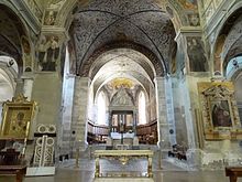
- 1 Farfa Abbey (in the hamlet of Farfa), ☎ 39 0765 277152, @[email protected]. The abbey of Santa Maria di Farfa was founded in the sixth century; between the eleventh and thirteenth centuries it became one of the most powerful monastic centers ofcentral Italy. Its prosperity began in 775, when Charlemagne granted the privilege of autonomy from any religious and civil power. The abbey still preserves some evidence of Carolingian architecture unique in Italy which can be distinguished in the base of the only bell tower that has come to us and in the perimeter wall at the base of the same, where the characteristic pilasters are perfectly preserved. The rest of the bell tower with the triple lancet windows is the work of a later period. Traces have been found in the structure that testify to the presence of the westwerk.
- The abbey church is located in the center of the complex: it is a basilica type with a Latin cross plan and three naves. The façade has salient features and has in the center a portal with a marble frame and surmounted by a fresco painted lunette depicting the Madonna and Child who is crowned by two angels between Saints Benedict and Scholastica. In the façade, which ends at the top with a simple triangular pediment, there are three rose windows, one in correspondence with each internal nave, of which the central one is larger. : The interior of the church, while maintaining the original structure, is in Baroque style, with the naves divided by two rows of round arches resting on Ionic marble columns. The counter-façade is entirely painted with Universal Judgment by Dirck Barendsz (1561).
- Beyond the cross, in line with the central nave, there is the deep polygonal apse with the wooden baroque stalls of the monks' choir. : The high altar is surmounted by the valuable ciborium which presents, on the cusp, the bas-relief of theAssumption of Mary.
- Collegiate Church of Sant'Antonino (Duomo). It dates back to the 16th century
- Church of San Giacomo. It was founded in 1619
- Church of Santa Chiara. It dates back to 1643. Today deconsecrated, it serves as a municipal ceremonial hall.
- Clarisse Hermit Monastery. Built in the 17th century on the ruins of the castle, it is still a cloistered convent.
- Orsini Palace. of the fifteenth century.
- Palazzo Farnese. of 1585.
- Palazzo Foschi. then Manfredi, from the 15th century.
- Castellani Palace. then Brancaleoni, now home to the Civic Museum.
- Grain storage and pawnshop. from the fifteenth century, today the seat of the municipal library.
- Tank, Piazza del Duomo. built by the Farnese in 1588.
Archaeological sites
- Remains of the pre-Roman city of Cures Sabini. Cures Sabini, or more simply Cures, or Curi is an ancient city of the Sabina mentioned by Cicero, Virgilio, Stazio, Strabone and Plutarco probably founded by the Sabines and was the most important Sabine city.
- The Cures foundation has strong affinities with those of Rome. Its founder Modius Fabidius would in fact have been generated by a girl of the Aboriginal people who would have joined with the god Quirino. Modio Fabidio founded his city and gave it the name of Curis, which in the Sabine language meant "spear".
- It was the residence of the Sabine king Tito Tazio, under whose reign the rape of the Sabine women and the subsequent agreement between the Romans and the Sabines are placed; it was also the place of origin of the second king of Rome, Numa Pompilius, and of the fourth, Anco Marzio, his nephew.
- Located on the Via Salaria in the Tiberine Sabina, it subsequently declined to become, in the Augustan period, a modest village.
- It then recovered in the first centuries of the Christian era, so much so that it became bishopric, indeed it is considered among the most ancient dioceses of Sabina, with a bishop, Tiberius, mentioned in 465.
- At the end of the sixth century, Pope Gregory the Great united it to the diocese of Nomentum, this indicates that the city had fallen into decline again. Perhaps it had already had to suffer, in a very serious way, Lombard attacks.
- It almost certainly survived until the 8th century when it was completely destroyed. In the locality some hamlets and villages were formed which belonged to the abbey of Farfa and which now constitute hamlets of Fara in Sabina (founded by the Lombards in the 7th century) along the Corese ditch.
- The remains of Cures are located in the district of Santa Maria in Arci. The ancient city must have occupied the entire hill south of Fara, surrounded by the two streams that flow into the Tiber.

- Ruins of San Martino. They are the remains of an imposing abbey dating back to the 11th century and never completed. The ruins are located on top of Mount Acuziano (489 m a.s.l.), which faces Mount Bruzio on which the urban agglomeration of Fara in Sabina stands. The history of the abbey of Fara in Sabina is linked to that of the abbey of Farfa: it was commissioned by San Lorenzo Siro, also founder ofFarfa Abbey, to replace the latter, which was destroyed after years of war and devastation.
- The oldest evidence dates back to the late Bronze Age: an ancient villa and the ruins of a temple dedicated to the Sabine goddess Vacuna have been ascertained on site. Cells for hermits were built on the remains of the villa, while the oratory was built in a cave. The ruins of the construction of San Lorenzo Siro, the liberator of Farfa according to legend for having defeated a dragon, are currently visible. The name of San Martino derives from the ancient oratory dedicated to Martin, bishop of Tours, where the 11th-12th century Farfa chronicler Gregorio da Catino died. In the 15th century, Pope Sixtus IV gave way to restoration works that destroyed the previous frescoes.
- In 1097, since the Farfa Abbey had sided in favor of the Emperor Henry IV and against the Papacy in the fight for investitures, the Abbot Bernard II planned to move the abbey to a more defensible place, on the top of the mountain. Acuziano, but the construction was never finished due to the death of the abbot. In 1142, despite the passage of the monastery under the control of the pontifical authority with the concordat of Worms, the abbot Adinolfo I decided to restart the work for the construction of the abbey, but on his death the work was interrupted again.
- The path
- The ruins of San Martino can be reached via a well-marked path with little difficulty: the start of the path is in the Quattro Venti area. Once on the top of Mount Acuziano, in addition to visiting the ruins of the Abbey, currently unsafe, you can observe the panorama: of the Tiber valley on one side, of Terminillo Pellecchia and Gennaro on the other, and of Fara in Sabina on the hill of front. Mount Acuziano is also a sheep grazing area.
Events and parties
What to do
Shopping
In its territory an excellent olive oil is produced; Fara in Sabina is part of theNational Association City of oil.
How to have fun
Where to eat
Average prices
- 1 L'Antica Bottega Restaurant, Via del Popolo, 35, ☎ 39 0765 277082.
- 2 La Caravella restaurant, Via Prime Case (in Primecase), ☎ 39 0765 386016.
Where stay
Average prices
- 1 La Raja farmhouse, Via dell'Arci, 22 (at Passo Corese), ☎ 39 0765 487036.
- 2 Stella d'Oriente farmhouse, Via Scarcialupo, 47, ☎ 39 0765 387713.
- 3 B&B Penucha Grove, ☎ 39 0765 387288.
Safety
![]() Pharmacies
Pharmacies
- Municipal Pharmacy, Via Borgo Nuovo, snc (Borgo Quinzio locality), ☎ 39 0765 398002.
- Farense Pharmacy, Via Farense, 99 (Coltodino locality).
- Passo Corese Pharmacy, via Enrico Fermi, 13 (Passo Corese locality), ☎ 39 0765486507.
How to keep in touch
Around
- Rieti - Considered by the authors of the classical age the geographical center of Italy (Umbilicus Italiae) was founded at the beginning of the Iron Age and became an important city of the Sabines; still today its territory is identified as "Sabina".
- Tivoli - At the gates of the city there are two UNESCO World Heritage Sites: the Roman Villa Adriana and the Renaissance Villa d'Este.
- Viterbo
- Rome
- Natural Reserve of Nazzano, Tevere-Farfa
Itineraries
- Via Carolingia - European itinerary that crosses the places traveled by the court of Charlemagne between the 8th and 9th centuries to travel from Aachen to Rome, where Pope Leo III crowned the Carolingian sovereign emperor of the Holy Roman Empire on Christmas night in the 19th century.
Other projects
 Wikipedia contains an entry concerning Fara in Sabina
 Commons contains images or other files on Fara in Sabina