| Imer | ||
 | ||
| State | Italy | |
|---|---|---|
| Region | Trentino Alto Adige | |
| Altitude | 670 m a.s.l. | |
| Surface | 27.60 km² | |
| Inhabitants | 1.168 (2015) | |
| Name inhabitants | almeroi / armeroi | |
| Prefix tel | 39 0439 | |
| POSTAL CODE | 38050 | |
| Time zone | UTC 1 | |
| Patron | San Pietro / San Paolo (June 29) | |
Position
| ||
| Institutional website | ||

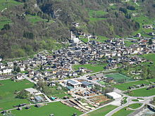
Imèr is a country in the Trentino Alto Adige in the province of Trento.
To know
The spoken dialect is the primoerotto.
Geographical notes
Imèr is located at the eastern end of the Trentino, 670 meters above sea level. It is at the bottom of the valley of the Primiero, before the beginning of the impervious Schenèr valley.
Its hamlets are Bus, Giani, Masi, Pontet and the village Sass Maór. It also borders on Canal San Bovo, Mezzano, Siror is Overmountain (BL).
When to go
The preferable season is summer for the favorable temperatures, but which sometimes become excessive. For this reason, the second suitable season is spring, which in any case has mild temperatures from mid-April.
For cross-country skiing enthusiasts, of course, the preferable months are December and January.
Background
How to orient yourself
Given the small size of the town it is difficult to get lost, however by going down to the valley floor you can orient yourself looking at the town with the distinguishable church.
How to get
By plane
The nearest airports are those of Trento is Bolzano. The international one is the Marco Polo of Venice.
By car
For those arriving from the south (Veneto) you reach Feltre (Belluno). Continue towards Fonzaso and then take the impervious Schener valley, which comes directly to the town.
For those arriving from the north you arrive at Predazzo (Val di Fiemme). It goes towards Bellamonte and doing the Passo Rolle it comes to San Martino di Castrozza. Going further down you find yourself in the upper part of the Primiero. Going down you arrive at Mezzano and then to Imèr.
On the train
The least remote railway station is that of Feltre.
By bus

The regional company Trentino Trasporti supplies connecting lines to Feltre and Trento.
How to get around
By public transport
The provincial company Trentino Trasporti provides continuous and regular connection lines to neighboring countries and nearby cities.
By taxi
There are no taxis passing through the streets, but only by reservation.
What see
Many buildings survive in Imèr that testify to the peasant life of the past and traces of popular habits.
The church of Saints Peter and Paul dates back to at least 1300 and is the building of greatest artistic importance.

Study holidays
For enthusiasts, the surroundings of the village are interesting from a geological and biological point of view, even though they have typical alpine characteristics.
In the Solivi or on Mount Vederna there are many possibilities for walks with interesting views; for fans in summer and autumn, the abundance of mushrooms is a common fact.
It is possible to walk to the small church of San Silvestro that overlooks the hamlet of Masi d'Imèr, from which you can enjoy a view over the whole of Primiero.
Events and parties
.JPG/220px-Chiesetta_di_San_Silvestro_(Imer).JPG)
The most typical events are the festival of Saints Peter and Paul and the Feast of the dumpling (Knödelfest).
More information on Imèreventi.
What to do
Shopping
How to have fun
Where to eat

Where stay
Safety
A carabinieri station is located in Imèr, along the state road near the border with Mezzano.
How to keep in touch
Post office
A post office is located in the center of Imèr.
Around
- Mezzano - It is part of the most beautiful villages in Italy.
- Tonadico
- Transacqua
- Primiero Fair
- Canal San Bovo