| Kirkenes | ||
 | ||
| State | Norway | |
|---|---|---|
| Region | Finnmark | |
| Inhabitants | 3.444 (2012) | |
| Prefix tel | 47 085 | |
| POSTAL CODE | N-9900 | |
| Time zone | UTC 1 | |
Position
| ||
| Tourism site | ||
| Institutional website | ||

Kirkenes is a city of Norway.
To know
Kirkenes is located north of the Arctic Circle and from May 15th, for about two months, it is possible to admire the phenomenon of the midnight sun; that phenomenon that, with the approach of the summer solstice, occurs above the polar circles where the sun never goes below the horizon and consequently never falls at night. Kirkenes, in the period between May 15 and July 28, never sees the sun set but in the winter, although the sun never rises above the horizon for over two months, the phenomenon of the so-called polar night: this is due to twilight which prevents total darkness from falling. In the winter months in Kirkenes, as in all areas above 60 ° north latitude, it is possible to admire the phenomenon of the Northern Lights.
Geographical notes
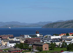
Kirkenes is located in the eastern part of the county of Finnmark, more precisely in the municipality of Sør-Varanger of which it is the capital, and is located a few kilometers from the Russian border.The city is located on the southern bank of the Varangerfjord on a point between the Langfjord and the mouth of the Pasvikelv river.
Background

The area has always been disputed between Norwegians and Russians and until 1826, the year during which the national borders were definitively delineated, both Russians and Norwegians jointly occupied the whole area. In the city there is still a Russian community that, after the dissolution of the USSR, tends to grow more and more (it is the only Norwegian city where the indications are also written in Russian). Iron mines were discovered in 1906, so Kirkenes became an important center for the war economy during World War I. During the Second World War the Nazis, sensing the economic and strategic potential of the area (a few kilometers from the Russian port of Murmansk), occupied the city with about 100,000 soldiers during the "silver fox" operation. Kirkenes at the end of the conflict was totally razed to the ground due to the clashes between the Soviets and the Germans. In more recent times the city has seen its mining site gradually decrease in importance as the exploitation of iron mines was no longer profitable for the steel industry and in 1996 the last mine was closed.
How to orient yourself
How to get

By plane
Kirkenes Airport, about 15 km from the city center.
By car
- European road E06
- It is also possible to reach Kirkenes from the north of the Finland (Street Rovaniemi about 7 hours) and from Russia northwestern (via Murmansk, about 4 hours border formalities).
- The port of Kirkenes is the terminus of the boat calls Hurtigruten. For a trip to Bergen it takes a week, in places like North Cape, Tromsø, Lofoten or Trondheim a couple of days.
On the train
The nearest train station is located at Bodø. For the adventurous spirits it is possible to connect to the Russian network in the border town of Nikel, traveling up to Moscow, Vladivostok, Ulaanbaatar is Beijing.
How to get around
What see

- Midnight Sun . This natural spectacle is called the midnight sun: the sun reaches its lowest level for the summer period until 01:00.
- northern Lights , in winter.
- 1 Grenselandmuseet (Area Museum), Førstevannslia, ☎ 47 78 994880.
 NOK 50, -. Northern Norwegian history and lifestyle, including a section devoted to the devastating effects of WWII on Kirkenes.
 - If you are going to cross the border with Russia, you will probably need a visa. In theory, this should be obtainable from the Russian consulate in Kirkenes. Start the paperwork one month before leaving home.
Events and parties
What to do

- Fishing, both in the sea and in fresh water, including salmon.
- Hiking.