 Längenfeld, hamlet "Dorf", Maria Hilf chapel | ||
| Längenfeld | ||
| federal state | Tyrol | |
|---|---|---|
| Residents | 4.611 (2018) | |
| height | 1,179 m | |
| Tourist info | 43(0)57200 300 http://www.laengenfeld.com/ | |
| no tourist info on Wikidata: | ||
| location | ||
| ||

The vacation and ThermenortLängenfeld is in the middle Ötztal and is the largest municipality in the valley in terms of population. The most important branch of the economy is tourism in summer and winter, Längenfeld is the starting point for activities in the surrounding mountains Ötztal and Stubai Alps.
background
The municipality of Längenfeld includes 21 other places and hamlets: Oberlängenfeld, Astlehn, Runhof, Gottsgut, Huben, Winkle, Bruggen, Aschbach, Im Brand, Burgstein, Gries in the Ötztal, Unterlängenfeld, Dorf, Dorferau, Espan, Au, Oberried, Lehn, Lehner-Au, Unterried, Winklen.
getting there
| Distances (road km) | |
| Imst | 35 km |
|---|---|
| Oetz | 18 km |
| Meran | 107 km (summer) |
| innsbruck | 75 km |
| Garmisch | 96 km |
| Munich | 202 km |
| Vienna | 567 km |
By plane
The nearest international airports are the Innsbruck Airport (Distance approx. 69 km, just under an hour's drive) and north of Munich the Munich Airport (also "Franz Josef Strauss", distance approx. 232 km).
By train
The nearest train station is that Ötztalbahnhof (own municipality) near Ötz and approx. 25 kilometers away in the Upper Inn Valley located. The station is a stop for regional trains innsbruck. Continue by bus or taxi.
In the street

Längenfeld is located in the middle of the Ötztal valley and on the Ötztalstraße (B186), which connects the Upper Inn Valley about the Ötztal and the Timmelsjoch (Winter closure) with the South TyroleanPasseier connects. The Ötztalstraße is the main road through the center of Längenfeld.
- Approach from the north through the Upper Inn Valley and the toll Inntal motorway A12, exit Ötztal and then about 23 kilometers further on the federal road B186 via Ötz to Längenfeld.
- Access via the is also toll-free from Germany Fernpass route to Imst and on the "Tiroler Straße" along the Oberinntal (B171, Landstraße !!) and then on the B186 into the Ötztal to Längenfeld.
mobility
She is responsible for public transport Ötztaler Verkehrsgesellschaft m.b.H., Tobe offered:
- Regular bus services in the Ötztal;
- The Ötztal Shuttle is an airport shuttle to the Innsbruck Airport
Tourist Attractions
- Parish Church of St. Catherine, in Längenfeld. Documented for the year 1303 and consecrated in 1352, expanded for the first time around 1518; The portal and the church are still late Gothic, expanded again in 1690 and redesigned in Baroque style on the inside. The church tower is the highest in the Ötztal.
- Plague chapel, on the Kropfbühel above Längenfeld. The chapel was built in 1661 at the plague cemetery (outbreak of the plague in 1614). The high altar dates from 1670, the rococo side altar by Hans Reindl dates from 1770.
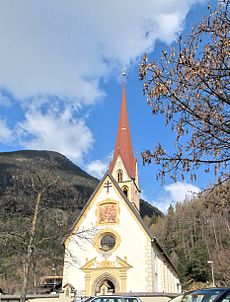
- Maria Hilf chapel, in the hamlet of Dorf. Built in 1740 in baroque style, baroque altar.
- 1 Ötztal local history museum, Lehn 24, A-6444 Längenfeld (in Lehn near Längenfeld). Open: from June 1st to September 30th.Price: Adults 4.- €., The museum shows the rural habitat in the Ötztal until the middle of the 20th century, also as a rural-social history museum. The center is a pair of courtyards with a storeroom and, as a contrast, a blocked side hallway house from the 17th century.
activities
- 1 AQUA DOME Tirol Therme Längenfeld (largest thermal bath in the Alps), Oberlängenfeld 140, A-6444 Längenfeld. Tel.: 43 5253 6400.
- Austria's most modern wellness world with several outdoor pools, sauna and water landscapes is located on a 50,000 m² area with the Tirol Therme Längenfeld, which opened in 2004 (day ticket 1 adult € 28.50 on weekdays).
In summer
- Ötztal Fun Park (Games, fun and adventure world), Mühl 257, A-6444 Längenfeld. Tel.: 43 (0)5253 5188 80. . Skate park, trampoline, giant swing, cable car, tube slides, climbing towers, "water and stones" geo playground, restaurant.
- Viewpoint suspension bridge wall gutter, on the eastern slope.
hike
- Devil's pulpit. Easy hike, starting point town center or bridge over Ötztaler Ache, detour to Plague chapel Possible after a few meters, viewing cliff on the western slope seen from the village, easily recognizable by the flag and viewing pulpit, from there circular route at the height towards Mittelastlehn (between Längenfeld and Huben).
- Hauerkogel. 2491 m, normal hike, ascent via Teufelskanzel from Mittelastlehn or Längenfeld.
- 4 lakes trail. Normal starting point Stabele or Innerberg Alm (approx. 1900 m), moderately difficult hike, once or twice a week "hut taxi" to the alpine pastures, guided tours with naturalist guides also possible, information at the tourist information (in Unterlängenfeld, directly on the main road).
- Gamskogel. 2813 m, ascent from Burgstein (1400 m) or via Gries (1600 m) and Nisslalm (2051 m) possible, better parking in Gries.
- Hörndle. 2985 m.
In the winter
The place can boast 50 kilometers of well-groomed trails.
For an overview of the ski areas see in Article Ötztal, For a complete overview, see also the article Ski areas in Austria.
shop
- 1 SAVE (Supermarket), Oberlängenfeld 38, 6444 Längenfeld. Open: also Sun. Open in the afternoon.
- 2 M price (Supermarket), Ober Längenfeld 103, 6444 Längenfeld. Open: also Sun. Open in the afternoon.
- 3 Fiegl sports hut (Sports shop, sports equipment rental), Ascender field 101 (next to M price). Tel.: 43 5253 5188 60.
- Längenfeld farmer's shop (regional products), Unterlängenfeld 88, 6444 Längenfeld (Fischbach Bridge). Tel.: 43 5253 5318.
kitchen
- Restaurant Cafe Alt Längenfeld (Butchery - local products), Ascender field 47b, 6444 length field (in the center of Längenfeld on the main road). Tel.: 43 (0)5253 5003.
- Gasthaus Mesner Stuben, Oberlängenfeld 24, 6444 Längenfeld (at the church in Längenfeld). Tel.: 43 (0)5253 6290. . Modern regional Tyrolean cuisine. The guest house is located in the listed former rectory and, since a renovation in 2013, offers a pleasant mixture of modern ambience in historic walls.
nightlife
- Country bar, Oberlängenfeld 47, 6444 Längenfeld. Tel.: 43 (0)5253 6472. Open: all year round from 7pm to 2am, closed on Sundays.
accommodation
The municipality gives 400 accommodations with 4,700 beds and 570,000 overnight stays per year.
- AQUA DOME Tirol Therme Längenfeld. Accommodation with 200 beds.
- 1 Apart Felsenhof (Accommodation with apartments), Huben 105, 6444 Längenfeld,. Mobile: 43-6765859213, Fax: 43-5253-5597-4, Email: [email protected]. Check-in: 14:00.Check-out: 10:00.
health
| Brief information | |
| surface | 195.84 km² |
|---|---|
| Phone code | 05253 |
| Post Code | 6444 |
| Mark | IN THE |
| Time zone | UTC 1 |
| Emergency calls | |
| police | 133 |
| fire Department | 122 |
| rescue | 144 |
- The nearest pharmacy is in Oetz.
- General practitioners and dentists are represented in town.
- The district hospital St. Vincent for the Tyrolean Oberland is located in Zams (approx. 32 km away).
Practical advice
- Ötztal Tourismus, Längenfeld information, A-6444 Längenfeld. Tel.: 43 (0)57200 300.
- Alpine Club - Weather service;
- Avalanche warning service for Tyrol
- Postpartner, 6444 Längenfeld, Oberlängenfeld 38 (SPAR store)
trips
- Glacier and hiking region all around Soelden and the Timmersjoch
literature
Web links
- http://www.laengenfeld.tirol.gv.at/ - Official website of Längenfeld
- Side of the Parish of Längenfeld
- Official site for the Oetztal