| Vercors massif | |
 | |
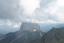
| Mont Aiguille in winter | |
| Information | |
| Country | |
|---|---|
| Region | Alps |
| Area | 1 350 km² |
| Location | |
 44 ° 56 ′ 47 ″ N 5 ° 31 ′ 59 ″ E | |
| Touristic site | |
the Vercors is a mountain range of French alps du Nord located in the departments ofIsere and some Drome In the region Rhône-Alpes. This massif is located to the east of the Rhône valley, between the valleys of Isère, to the north, and Drôme, to the south.
The Vercors regional park encompasses the entire massif as well as the neighboring regions. The nature reserve of the high plateaus of Vercors protects the plateaus located to the south of the massif, as well as Mont Aiguille.
Understand
The Vercors massif is a good holiday destination for people practicing outdoor sports such as hiking, cross-country skiing, mountaineering, caving, etc. The Vercors can also be of interest to people who just want to take a drive, because it contains very beautiful, vertiginous roads and diverse landscapes. Around the Vercors are different regions of Piedmont, with climates that can be Alpine (Triève) or Mediterranean (Drôme valley)
Geology
The Vercors massif is a group of limestone plateaus surrounded by cliffs that can reach 300 meters height. Transitions between plateaus can be gorges, cliffs, or gentler slopes. The highest plateaus are in the south-eastern part of the massif, where the summit of the Vercors, the Grand Veymont (2 341 m). In this part of the park, the massif is bordered by an almost continuous cliff of several tens of kilometers.
These landscapes can be explained by a complex geological history, which will be summarized in three stages:
- During the secondary era, the future massif of the Vercors was a tropical sea, the bottom of which has been more or less deep over the ages. When the bottom was at great depth, fine sediments were deposited and formed soft marls. When these funds were flush with the water, coral reefs were able to develop. These reefs are at the origin of the hard and clear limestones visible today along the cliffs of the Vercors. Coral reefs have developed particularly during two periods:
- The "Tithonic" limestones were formed during the Middle Jurassic and are visible on the outskirts of the plateau, in the Diois and the Trièves, where they form relatively small cliffs.
- The "Urgonian" limestones, forming a thicker layer, are at the origin of all the large cliffs bordering the massif, the gorges, and Mont Aiguille.
- The Tertiary era saw the uplift of the Alps, including the Vercors. At the level of the massif, under the action of moderate compressive forces oriented east-west, the limestone and marl layers have formed large folds of often quadrangular section and a certain number of faults. These folds and faults are at the origin of the alternation of lower then higher plateaus, especially visible to the south of the massif.
- Finally, erosion has sculpted over the millennia the gorges and cliffs visible today. The cirques and gorges of the Vercors were mainly hollowed out by liquid water, because the Vercors was not covered by ice during the glaciations. Karst erosion (that is to say the chemical erosion of limestone by water) is at the origin not only of the gorges and cliffs of the Vercors, but also of the many caves, sinkholes, wells (locally called scialets), lapiaz, and dry valleys visible in the massif.
- One site very detailed on the geology and landscapes of the Alps, including the Vercors.
Landscapes and regions of Vercors

Before the end of the XIXe century, the different parts of the Vercors massif were isolated from each other, and only had relations with the surrounding plains. The gorges crossing the massif, and which are sometimes today its main axes of communication, were insurmountable obstacles. The massif was humanly divided between places communicating with Royans (Coulmes), those communicating with Grenoble via the valley of Furon (Four mountains), and what was then called Vercors. We have divided this last part here between the Vercors Drômois, more humanized, and the reserve of the highlands, wilder.
- The Coulmes, to the north-west, has always been the most wooded part of the massif. The forest was exploited in the XIXe century to make charcoal, particularly by people of Italian origin, who bequeathed us one of the regional dishes of Vercors, ravioli. In this region, the Vercors looks more like a mountain than a succession of plateaus, the folds of the Urgonian limestone being more rounded. Several impressive roads lead to the Coulmes, in particular the Nant gorges road, and the Ecouges gorge road.
- The Four mountains are today the most developed area of the Vercors for tourism, in particular cross-country skiing and downhill skiing. This region is very popular with Grenoble residents for their weekend outings. Nevertheless, there are still traditional activities in the four mountains, in particular dairy cattle breeding and cheese production. The four main villages (Autrans, Méaudre, Lans en Vercors and Villard de Lans) are spread over two plateaus separated by wooded mountains. These four villages are ski resorts but still have working farms. Beautiful photos of the four mountains, and other areas around Grenoble are visible on the site photos-dauphine.com.
- the Vercors Drômois consists of smaller, but more numerous platters. Some of these plateaus are spectacular (Ambel, Font d'Urle), and offer beautiful views over one another or over the surrounding plains. North of the Vercors Drômois are several gorges crossed by impressive roads carved into the cliff. The grassy plateaus of the Vercors Drômois are used as mountain pastures in summer. The transhumance is the occasion of a festival in Die.
- The nature reserve of Highlands Vercors is the highest, wildest and most protected area of the massif. This area has no permanent residents, no paved roads, and no motor vehicles are allowed. The only economic activities are the exploitation of forests according to the model of the cultivated forest and the use of pastures as mountain pastures in summer.
On the perimeter of the massif, the Vercors regional park partially or completely covers four other geographical areas:
- the Royans, to the north-west, is a hilly region dedicated to the breeding and cultivation of walnut trees. Three of the most impressive gorges of the Vercors converge towards the Royans: the gorges of the Bourne, the cirque of Combe Laval, and the valley of Echevis, comprising the small and the large bottlenecks.
- The Gervanne, in the southwest, is an area of rugged hills at the foot of the plateaus, where there are pretty villages.
- the Diois, to the south, corresponds to part of the Drôme valley around the town of Die. This area has a more marked Mediterranean character, with vineyards and lavender fields. In this area, three AOC wines are produced: Clairette de Die, Crémant de Die and Chatillon en Diois wine.
- the Trièves, to the east, is a low hilly plateau, between the summits of Vercors and the gorges of Drac. It is from the Trièves that we have the most beautiful views of Mont Aiguille.
Story
The Vercors owes its name to a Celtic tribe living in this mountain at the time of the Roman invasion: the Vertacomicorii. Occupation was limited during the Roman era to the piedmont areas. The plateau was exploited seasonally, the most visible trace of this exploitation being quarries in the south of the highlands.
During the Middle Ages, the massif was gradually colonized, starting with the "Vercors valley", comprising the Chapel, Saint Julien, Saint Martin and Saint Agnan (the suffix "en Vercors" being a recent addition)
During the XXe century, this massif was used as a natural fort by one of the most important maquis of the Second World War. At the beginning of 1944, these mountains were home to 4000 combatants aided by a massively favorable population. On June 6, 1944, the roads leading to the plateau were cut off and the Republic of Vercors declared.
the , 15,000 German soldiers invaded the plateau using small "steps" in the cliffs, and planners. 600 resistance fighters and 200 civilians were killed, often in atrocious conditions.
On a lighter note, twenty-four years later, this is also where many events of the 1968 Winter Olympics took place.
Flora and fauna
We find in the Vercors both animals from the hilltop (stag, roe deer, hare, wild boar) and mountain and alpine floors (mouflon, chamois, marmot, mountain hare). At the end of the XXe century, the wolf (canis lupus) made its spontaneous appearance (from Italy) forcing shepherds to adapt their activity (nocturnal enclosures, patou dogs).
Many species of birds are also visible. Here again we find both highland and lowland species. The site chocard.com presents the 140 species of birds that have been observed in the Vercors massif with a distribution map and a description sheet for each of them.
The flora of the Vercors is also very diverse, with 28 protected species including the wild tulip, the edelweiss and the hoof of Venus. Among the more frequent and easy to observe species, we can note the great gentian, the spring gentian, the flaxseed of the Alps, the wild narcissus and saxifrage.
To go
By car
The towns closest to Vercors are Grenoble, Romans-sur-Isere, Valence and Die. Valence is accessible by motorway from Paris, the south of France and Spain, Grenoble is accessible by motorway from Switzerland and Italy. From each of these towns, the regional park can be reached in less than half an hour.
- Since Grenoble the main entrance to the massif is via the Gorges du Furon (D531, direction Lans-en-Vercors).
- Since Novels, take the N532 north-east in the Isère valley, to the town of Saint Nazaire en Royans. From there take the D76 or the D531 to the east. These two roads lead to the park, in Royans. From there, several roads go up towards the interior of the massif.
- Since Valence, you can go to Romans using the N532, or go directly to the massif by taking the D68 towards the east (Col des Limouches) or by taking the D171 to Alixan, then the D101 towards the Col de Tourniol.
- Die is inside the regional park. It can be accessed from Valence via the D93. From Die, you can go up to the plateau by crossing the Col du Rousset (D518).
- There is no access road to the massif from the foothills between Grenoble and the Rousset pass.
By train / plane
The major stations closest to the massif are Valence TGV, Valence Ville and Grenoble.
- Valence train station TGV receives TGV from Lyon, Lille, Paris, Montpellier, Nantes and Marseilles daily. During school holidays, Thalys trains from Amsterdam, Antwerp and Brussels stop at this station.
- Valence ville station receives trains from Nice and the French Riviera, Briancon, Gap, Lausanne, Geneva, and buses from Privas and Aubenas in Ardèche.
- The station Grenoble receives TGV from Paris, Geneva, Lausanne, Chambery, and trains from Gap, Digne-les-Bains, and D'Italy (Turin, Milan, Venice).
There are stations in the regional park:
- Die station is served by three daily trips on the Valence-Gap line.
- The stations of Clelles and Saint Michel des Portes are served by six daily rotations on the Grenoble-Gap line.
The nearest international airport is Grenoble-isère[1], located at 40 km from Grenoble, allowing you to fly to London by EasyJet all year round, but also to many winter destinations (Stockholm, Saint Petersburg, several British cities, etc.).
Lyon Saint Exupéry international airport (Satolas) is located 100 km. From the airport, it is possible to take TGV to Valence or Grenoble (30 min). Saint Exupéry airport receives planes from other French international airports (Orly, Roissy, Toulouse, Nice), most European countries and the Middle East (Turkey, Israel), North Africa (Algeria, Morocco, Egypt), from Canada, and DOM-TOM (The meeting, Guadeloupe).
Paris Charles de Gaule airport, although located further away from the massif, has a greater number of lines, and can be reached directly by TGV from Valence (2 h 30 distance) and Grenoble (3 h path).
By bus
It is possible to get to the Vercors regional park by coach from the cities of Grenoble and Valence. Lines also exist between the town of Die and other villages in the park.
- From Grenoble, there are three regular lines:
- Towards the four mountain resorts (Autrans, Corrençon, Lans en Vercors, Méaudre, Saint Nizier, Villard de Lans)
- Towards the villages of Royans: Saint Jean, Saint Laurent, Sainte Eulalie and Pont en Royans.
- Towards the Trièves: Gresse, Clelles.
These lines are managed by the Transisère bus network. website
- From Valencia, there are four regular lines:
- Towards Die (Line 28) (You can also get from Valence to Die by train)
- To Combovin (line 7, 2 rotations per day)
- Towards Beaufort sur Gervanne and Plan de Baix (Line 25, 1 rotation per day)
- Towards the villages of Royans (The same as from Grenoble, Line 5, 7 rotations per day). At certain times (one to two per week), the line continues to Vercors Drômois. It serves La Chapelle en Vercors, Vassieux, Saint Agnan and Saint Martin en Vercors.
- From Die, a bus line (Line 29, one rotation every two hours approximately) serves several villages of Diois included in the Park, including Châtillon en Diois.
The lines from Valence and Die are managed by the General Council of Drôme (CG26). Telephone: 04 75 81 72 62, website.It is also possible to benefit from "feeder services" such as transport on demand, for a price ranging from 2,5 € To 5 €, the rest of the journey being taken care of by the General Council, between the villages of Vercors Drômois and the terminuses of the bus lines in the plain. Reservations for such services must be made at least 24 h in advance, usually at the Tourist Offices.
Circulate
Public transport is scarce on the plateau, and it is better to have a personal means of transport (car, motorbike). It is also possible, and even very pleasant, to get around by bike, but the numerous passes of the massif are only accessible to trained people.

Four main roads run through the plateau, in a general north-south direction: D531 leaves from Grenoble to the south. It goes up towards the massif along the gorges of Furon to Villard de Lans. It then slopes west along the gorges of the Bourne. After impressive passages, the road leaves the gorge at Pont en Royans. It then continues towards Saint Nazaire en Royans, then Romans, towards the south-west.
The D76 leaves from Saint Nazaire en Royans south-west towards Saint Jean en Royans. From there, it climbs towards the Col de la Machine along a very aerial course carved into the cliffs of Combe Laval. This road continues south-west towards Vassieux en Vercors, then the Rousset pass.
There is a road between the Rousset pass and the D531 which does not leave the massif: It begins in the gorges of the Bourne (D101) and joined the barracks in Vercors. There, it changes its name (D518) and continue south towards the Chapelle en Vercors, Saint Agnan en Vercors, then the Col du Rousset. From there the D518 descends towards Die.
The D199 heads west from Col de la Machine to Col de la Bataille. In Léoncel, it takes the name D68, then it joins the plain of Valence via the Col des Limouches.
The small road D70 crosses the Gervane between the Col des Limouches and the valley of the Drôme. She crosses the Col du Bacchus.
The Diois is crossed by the D93. This wide road crosses at Die la D518 which crosses the Rousset pass.
The Trièves is crossed by the N75.
Many other small roads are present on the massif, and join together the different villages. There are a very large number of small road passes between the massif and the surrounding plains such as the Col de la Croix, the Gorges du Nant, the Col du Mont Noir, the Col de Romeyère ... The route des Grands goulets (D518) is unfortunately temporarily cut off following a major landslide in the cliff. A tunnel is being built to reestablish this connection.
To see
Nature
- The roads of vertigo in the Vercors gorges, in particular Combe laval (D76) and Les Grands Goulets (D518) open to Royans, Les gorges du Nant (D22 north-west of the massif), and the balcony of Ecouges (D35, north of the massif).
- The site of Combe Laval, from Saint Laurent en Royans, includes the resurgence of cholet and the belvedere of the cross of Saint Laurent. We can also admire a tuff waterfall at the level of the Carthusian bridge.
- The Bronzed Fir, a fir tree of exceptional age and size, in the Lente forest.
- The many Caves landscaped Vercors. The most spectacular are:
- The Choranche caves towards Pont-en-Royans, which are known for their rare concretions.
- The Thais cave in Saint Nazaire en Royans, which contains beautiful concretions and reveals beautiful natural rock colors. The cave was a prehistoric shelter for Cro Magnon men. Self-guided tour for individuals with guided and commented route. Full price entry: 6,5 €. Phone: 04 75 48 45 76.
- The Draye Blanche cave near La Chapelle en Vercors. Rare fossils from the Ice Age are visible. The visit of the cave is completed by that of a zoo. Full price entry: 6 €. Phone: 04 75 48 24 96.
- The Luire cave near Saint Agnan en Vercors, which allows you to see large underground spaces and an impressive well. Full price entry 5 €. Phone: 04 75 48 25 93.
- the Gorges of the Druize, on the borders of Gervanne and Vercors Dromois.
History and culture
- the Resistance Memorial in Vassieux-en-Vercors. Phone: 33 4 75 48 26 00
- The 13th chapele century in the village of La Chapelle en Vercors
- THE' Léoncel Abbey (XIIIe century)
- The village of Pont-en-Royans and its houses built overhanging the Bourne.
- The village of Saint Nazaire en Royans under its aqueduct 35 m (XIXe century). This aqueduct is still in water, but can also be visited.
- The old town of Die.
- The museum of prehistory
- at the Combe Laval site, the Carthusian Bridge, the monks' path, the ruins of Saint Mémoire, but above all the very beautiful orthodox monastery Saint Anthony the Great founded in 1978.
- Each year, Autrans organizes the international mountain film festival at the end of November. [2]
Do
Hiking
Here is a selection among the many hikes that can be done in and around the Vercors massif.
- Around the plateau:
- the Archiane Circus allows several walks. It is possible to climb from the bottom of this circus to the Jardin du Roi, on the high plateaus. The trail alternates between wooded or very mineral landscapes in an impressive dry valley. It is also possible for those who do not fear vertigo to follow a ledge on the side of the cliff around the circus.
- the Mont Aiguille is a small portion of a plateau surrounded by high cliffs. A nice day hike goes around it from the village of Chichiliane in the Triève.
- the No needle is a pass towards the high plateaus which offers a panorama of Mont Aiguille and can be the goal of a day trip from Chichiliane. It is also possible to make a loop from this step by crossing the high plateaus towards the Pas de l'Essaure, which connects the valley of Combeau and the valley of Chichiliane.
- In the Vercors Drômois:
- The tour of Ambel Plateau, from the Col de la Bataille (1 340 m): a nice one-day walk along the cliffs bordering this plateau.
- the Plateau of Font d'Urle from the small station of the same name. Another walk along the cliffs, which also offers superb flora, and allows you to admire different karst formations (lapiaz, scialets). Variant, the climb (1 h) to the Head of the Baume (1 591 m.) with a view of the 70 km from the eastern barrier of the Vercors.
- the Pas du Pas, from St Laurent en Royans; variant by the Roche des Arnauds, 1 418 m., magnificent belvedere placed in the center of the Vercors. (Well signposted)
- the Not from Allier from Echevis. (Complete circuit by No vaults)

- In the Four Mountains:
- the Beak of the Orient, 1 554 m. A nice view of the Isère valley, after a one hour ascent.
- the Flycatcher, 1 901 m, a walk of 6 h, nice view of the city of Grenoble.
- The Great Flycatcher, 2 284 m.
- The Nature reserve of the Hauts Plateaux du Vercors is only accessible on foot. It is one of the few wild landscapes in Europe. Among the many possible hikes, we can mention:
- the Grand Veymont, summit of Vercors (2 341 m) This is a full day hike, best started early in the morning, due to thunderstorms.
- The Roman quarries are a nice destination for a stroll, from Diois or Trièves. This is also a full day hike. You can still see old barrels of columns in the quarries.
Cross-country skiing
The Vercors offers one of the largest cross-country skiing areas in Europe. Thus, in the heart of winter, it is possible to connect Saint Nizier du Moucherotte, to the north, to Vassieux en Vercors and the Rousset pass, located to the south of the massif. The resort of Villard de Lans-Corrençon is internationally renowned for its domain of several hundred kilometers. The Autrans resort is also known for its many cross-country ski trails.
- To discover, the superb site of Vercors South with its 3 entrance gates: Font d'Urle - Chaud Clapier, Lente and Col de Carri (160 km of perfectly groomed slopes).
Each year, two cross-country ski races mark the Vercors ski season:
- in January, the Foulée Blanche, around Autrans, is a large gathering of skiers from the region
- in March, the Grande Traversée du Vercors (or GTV) between the Col du Rousset and Villard de Lans, is reserved for seasoned skiers
Downhill skiing
The Vercors has several stations offering ski lifts:
- Villard de lans-Corrençon (the largest ski area)
- Gresse en Vercors
- The Rousset pass
- Lans en Vercors
- Autrans / Méaudre
- Font d'Urle-Chaud Hutch
Paragliding
The Vercors massif, with its many cliffs, is very suitable for paragliding, with several take-offs accessible near Lans and Villard. (professional paragliding school, and local clubs at Lans en Vercors and St Marcellin
Caving, canyoning
The Vercors massif is a high place of French speleology, and also includes many canyons. Among the most famous caves, we can mention:
- 1 The Luire cave (near Saint-Agnan-en-Vercors) – features tubes with very pure shapes.
- 2 Gournier cave (near Choranche)
- 3 The blowing hole (near Autrans-Méaudre en Vercors)
- 4 The Berger chasm (near Engins) – One of the deepest networks in the world.
- 5 Bournillon cave (near Châtelus (Isère))
Some canyons of the Vercors:
- The Ecouges gorge – in the Coulmes, a very beautiful canyon, but quite difficult.
- The Furon canyon – easier.
- The Léoncel canyon – in Royans
- The three badgers – a large waterfall to abseil.
- The Rio Sourd – a very pretty canyon south of the park, in the Diois.
Those interested in an introduction to caving or canyoning can contact
- Caving & Water ,
 33 7 60 95 72 63, e-mail : [email protected]
 - Canyon Outing 4 chemin de l'eau vive, 38360 Sassenage, 33 6 58 88 46 08
- Vercors instructors office 15 BC des Francs-Tireurs, BP 25, 38250 Villard-de-Lans, 33 4 76 94 14 50
- Vertical Adventure , 33 6 63 70 36 25 – Caving, canyoning and climbing instructors in the Vercors.
- Spirit of the mountains , 33 6 83 29 93 14 – mountain guide, caving, canyoning and climbing instructor in the Vercors
Escalation
The numerous cliffs of the Vercors make this massif a paradise for mountaineering. The most classic (and one of the most beautiful) climb is that of Mont Aiguille, which can be done in several ways.
To buy
Eat
Regional specialties
- The Ravioli, a kind of small ravioli with cheese and herbs, are often served as an accompaniment in restaurants. They are also found in grocery stores and supermarkets.
- The Walnuts, produced in part in the park (Royans) are famous.
- The Abomasum is a kind of pork offal mixed with herbs and wrapped in pork strainer. Each producer has his own recipe. Caillettes are eaten cold or warm, spread on bread. It can be found in all the delicatessens in the park, but also in neighboring regions.
- the Gratin dauphinois is a dish from the region.
- The Cardoons are a vegetable which we eat the ribs, in sauce or au gratin. They are found throughout the region, from the Mediterranean to French-speaking Switzerland, and passing through the Vercors.
- the Pogne and the Saint-Genix, pastries that can be found in bakeries and pastries in the park, are specialties of the region, in particular the town of Romans.
Cheese
- the Vercors-Sassenage blue is an AOC cheese made from raw cow's milk produced on the Vercors plateau. It is possible to melt this blue cheese, softer and mellow than most other blue, more tasty.
- the Saint Marcelin and the Saint Felicien are produced in the Isère valley between Romans and Grenoble from raw cow's milk.
- the Picodon is an AOC goat cheese made from raw milk produced in the departments of Drôme and Ardèche.
- the Little Leoncel produced in the charming Dromois village of the same name (cow's milk cheese).
- the Rocherousse is a baked cheese in the same genre as Comté. This is a specialty of the Rocherousse farm in Saint Martin-en-Vercors, located just under the cliff of the same name.
- Although farm-produced cheeses are generally the best, some small companies, including Etoile du Vercors produce excellent ones.
Restaurants
- In the Four Mountains:
- At Autrans, Restaurant "La Buffe", Telephone: 04 76 94 70 70, Fax: 04 76 95 72 48, email: [email protected], Website. Menus 19 to 45 €, possibility of children's and vegetarian menus. Among the musts, the chicken fricassee with crayfish.
- Restaurant Barnier in Autrans
- In the heart of the village of Méaudre, the restaurant of the inn The Hoof of Venus offers traditional cuisine with regional products. Menus at 12, 18 and 23 €, children's menu at 8,5 €. The hostel also contains 7 rooms for 2 to 4 people. Phone: 04 76 95 20 02, fax: 04 76 94 29 35, email: [email protected]
- In the Vercors Drômois [3]
- In Royans
- The Table des Forges in St Laurent en Royans, Telephone: 04 75 47 67 50. Specialties of Cholet trout and ravioli.
- The Tracols in St Laurent en Royans,
- The Piccouly in St Laurent en Royans, Telephone: 04 75 47 58 57. Regional specialties, local products, pizzas.
Have a drink / Go out
- Local spirits
- The gentian is a bitter digestive liqueur, produced by steeping the roots of gentian in a mixture of fruit alcohol and sugar. This liqueur is produced in many mountainous regions, including the Vercors. The majority of the production is for personal use and is not sold. However, you can find this liqueur in some local produce stores in the park.
- the Nut wine, produced from walnut stain, alcohol, sugar and wine, has a similar story. A commercial production begins to emerge in Royans, and we begin to find this liqueur in certain stores of the park.
- the Châtillon en Diois is the only wine produced inside the park. The little (65 Ha) production area is in the extreme south-east of the park, around the village of Châtillon. This calm wine exists in red, rosé and white. The red and rosé wines mainly contain Gamay to which is added Pinot and Syrah. The white wines are a blend of Aligoté and Chardonay. These grape varieties are generally used further north, but they are well suited to this terroir, due to its altitude (700 m).
- The Clairette and the Crémant de Die are sparkling wines produced on the land of Die in the Drôme valley. Clairette is a blend of grape varieties Muscat à petits grains and Clairette. Crémand only contains grape variety Clairette.
- A little further is the Rhône valley, with all its prestigious appellations, the closest to Vercors being Cornas, Tain l'Hermitage, Croze Hermitage and Saint-Joseph.
Housing
- In Autrans:
- Hotel la tapia Autrans-Méaudre en Vercors (in Autrans), 33 4 76 95 33 00, fax : 33 4 76 95 38 63 –
 , Small hotel with 10 rooms in the village.
 - Post office Autrans-Méaudre en Vercors (in Autrans), 33 4 76 95 31 03, fax : 33 4 76 95 30 17, e-mail : [email protected]
 from 50 to 100 €. –
  , rooms and suites.
 - Cottage Les Épérières The Bourg de Dessus, Autrans-Méaudre en Vercors (Cross the village to the north in the direction of Gève) from 290 €. – This old farm houses three fully equipped lodgings for 2 to 4 people. Slightly out of town (10 min walk), they are located at the start of several hikes for the summer or snowshoes for the winter.
- In Méaudre:
- Rural gîte of M.Chambon Autrans-Méaudre en Vercors (in Méaudre), 33 4 76 95 21 06, fax : 33 4 76 95 23 98 – five apartments on the first, second and third floor of the owner's house.
- In the Font d'Urle resort:
- Vacanciel les pledges (in the resort of Font d'Urle), 33 4 75 48 27 48, e-mail : [email protected] from 56 € half board. – vacation center in rooms for 1 to 5 people, restaurant, bar, mountain and aquadétente areas.
- In Royans:
- The Fountain of Vercors Saint-Thomas-en-Royans (on the D76), 33 4 75 47 56 19 – guest rooms in Royans.
- Hotel Le Castel Fleuri Saint-Jean-en-Royans – , restaurant, swimming pool, park, Logis de France
- In the Vercors Drômois
- Vercors Drôme Tourist Office BP5, 26420 La Chapelle-en-Vercors, 33 4 75 48 22 54 (La Chapelle-en-Vercors), 33 4 75 48 61 39 (Saint-Jean-en-Royans), 33 4 75 48 49 80 (Saint-Nazaire-en-Royans)
 Mon.- sat. : 9 h - 12 h and14 h - 18 h. –
  free.
free. - Gite La Combeuse hamlet in Saint Martin-en-Vercors, 33 475455169
- Hotel Le Col de la Machine at the Col de la Machine (between Saint-Jean-en-Royans and Bouvante) –
- The Sareymond hamlet of La Menée, 26410 Treschenu-Creyers, 33 4 75 21 73 66 – rooms and table d'hôtes.
- In the Trièves
- La Petite Datcha in Chichilianne from 24 €/ night / 2 people, free for children under 15. – nature holidays in Vercors-Trièves.
- The house of Mont Aiguille in Chichilianne, 33 4 76 34 44 95 from 16 to 19 €/ person / night.