| Spelonga | ||
 | ||
| State | Italy | |
|---|---|---|
| Region | Marche | |
| Altitude | 946 m a.s.l. | |
| Inhabitants | 265 (2001 census) | |
| Name inhabitants | Spelongani | |
| Prefix tel | 39 0736 | |
| POSTAL CODE | 63096 | |
| Time zone | UTC 1 | |
| Patron | Sant'Agata | |
Position
| ||
| Institutional website | ||

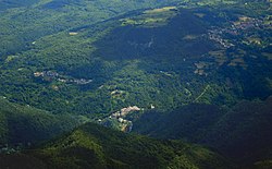
Spelonga is a fraction of the municipality of Arquata del Tronto in the province of Ascoli Piceno, in the region Marche.
To know
The town is one of the most populous in the Arquatano area. It is known throughout the Piceno territory for giving life, every three years, to the Beautiful party.
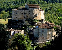
The village is made up of numerous houses, many of which retain their ancient appearance with stone walls, with external stairways and small loggias. On the architraves of the doors, there are bas-reliefs almost everywhere, the most recurrent one bears the figure of an angel in flight.
To the name Spelonga, in more ancient times Aspelonga, two different imaginative origins have been attributed. The first is the derivation from the term cavern, understood as cave - natural cavity. The second from the German term aspe indicating a variety of poplar (long, tall poplar) from which the Greek derives aspis, shield in the sense of shelter, protection in general therefore a place where there is shelter, refuge. This second hypothesis would be supported by the fact that the Ascoli historian Gabriele Rosa, describing the abandonment of the city of Ascoli in the year 590, by its population frightened by the threat of the invasion of the Lombard duke Faoaldo di Spoleto, speaks of Spelonga and others countries as places where the fugitives found a safer shelter.A further hypothesis sees the toponym deriving from the Latin terms aspis (or aspes) longa, or "long snake", due to the shape of the country itself.
Geographical notes
Spelonga, like the municipality of Arquata del Tronto, has the territory between two national parks: the Monti Sibillini National Park and the Gran Sasso and Monti della Laga National Park.
The inhabited center enjoys a beautiful view of the capital since it is housed on the hill facing the Rocca di Arquata, an ancient medieval fortress that dominates the capital and the entire valley with its towers.
When to go
The town can be visited in every season of the year having a typical mid-mountain climate with mild springs and summers and winters with some snowfall.
How to orient yourself
The town is located between the hamlets of Faete and of ColleIt can be reached by leaving the SS4 (Salaria) near Trisungo and continuing on the SP20 which leads to Faete, Spelonga and Colle.
How to get
By plane
The nearest airports are:
- Raffaello Sanzio of Falconara (Marche),
- Free of Pescara (Abruzzo),
- Fiumicino is Ciampino of Rome,
- Umbria International Airport of Perugia.
By car
Highways:
- A14: exit San Benedetto del Tronto.
Ordinary viability:
- SS4 Salaria
On the train
The nearest railway station is that of Ascoli Piceno.
How to get around
The means to move with greater comfort are the car and the motorbike, during the summer it is also advisable to take a bicycle. Inside the town the roads are in good condition and by car it is possible to get to the center of the encased. The rest of the urban fabric is connected by alleys, which can also have a moderate slope, which can be traveled on foot or by bicycle and can also be used by people with disabilities.
What see
- Church of Sant'Agata. It is the parish church of Spelonga, dedicated to Saint Agatha, virgin and martyr, located on the square, inside the town. It was built in the second half of the 1400s and has a very simple facade, opened by a single portal in local sandstone, with references to the Renaissance style, added to the sacred building after its construction. The particularity that most characterizes the church is the presence, inside, of a combat flag, with a Muslim coat of arms, which was snatched by the Spelongans from a Turkish ship in 1571, during the Battle of Lepanto. This war trophy is kept in a framed glass case, placed to the left of the main altar. Since 1933, following the demolition of the church of Santa Maria di Loreto in Collepiccioni, the church of Sant'Agata houses many artistic assets that were transferred there, including: frescoes from the Umbrian school, from the late fifteenth century, tempera from the seventeenth century century, a terracotta group of Abruzzo sacred art, from the sixteenth century, placed on the high altar, in addition to the flag of the Battle of Lepanto. On the walls there are also other original frescoes from the church of Sant'Agata, commissioned by the Martorelli family. The interior develops in a single rectangular room covered by an exposed truss ceiling. A special mention deserves the high altar, from 1631, made of carved walnut wood, which houses the polychrome terracotta group by Sebastiano Aquilano in the center. Another wooden altar, built in 1638 by the brotherhood of the Santissimo Rosario, is located on the right wall, near the side entrance. Some of the frescoes of the late fifteenth century, which come from the demolished church of Santa Maria were made by Bernardino Campilio da Spoleto (for years mistakenly identified as "Panfilo da Spoleto"). On the right wall there is the Madonna di Loreto, from 1483, on the left San Bernardino, from 1482, Sant'Agata and San Lorenzo portrayed with the instruments of their martyrdom. The frescoes of 1500 were painted by local painters inspired by both the Umbrian school and the style of Nicola Filotesio, known as Cola dell'Amatrice. In the presbytery there are the images of the Four Evangelists who were present in the lunettes of the old church of Santa Maria.
Events and parties
- 1 The Beautiful Party, Spelonga hamlet (coming from Ascoli Piceno, take the SS4 towards Rome and arrive at Trisungo, then continue towards Spelonga. Coming from Rome, take A90 towards exit 10, Firenze del GRA and exit towards Fiano Romano, follow SS4DIR and the SS4 exit towards Rieti, near Rieti turn right and take SS675 - SR675 and then take the SS4 towards Ascoli Piceno and arrive in Trisungo, leave the SS4 and follow the direction Spelonga.). Event held every three years in August, designed to commemorate the participation of the inhabitants of the hamlet in the battle of Lepanto in 1571. In the center of the town square, the hull of a Turkish ship is rebuilt, equipped with a mast and on top a copy of the flag is hoisted which, according to tradition, was torn off in battle and brought back to town. The flap of the original flag is kept inside a reliquary in the local church of Sant'Agata.
What to do
The activities that can be practiced differ according to the seasons.
- Excursions. During the hottest periods it is possible to follow paths and hiking trails to be tackled by bike, mountain bike or on foot, to be chosen from different degrees of difficulty.
Shopping
How to have fun
Where to eat
Where stay
- B&B Giardino dei Monti, Spelonga, 67 / A, ☎ 39 329 0197 663. The property is located in the center of the village, has two double bedrooms with bathroom, a living room with fireplace and a garden from which you can see Mount Carrier.
- B&B L'Arco Di Filippò, Via dell'arco, 78, ☎ 39 0736 809265.
Safety
List of telephone numbers that can be useful during a stay:
- 2 Carabinieri Command Station, Via Roma, 1C (Arquata del Tronto), ☎ 39 0736 809152. Arquata barracks.
- 3 State Forestry Corps, Via Bucciarelli, 11 A Borgo hamlet, ☎ 39 0736 809151, @[email protected]. Seat of the Regional Coordination of the State Forestry Corps - Ancona
- Alpine Rescue Lazio, ☎ 39 348 6131300.
- Alpine Rescue Abruzzo, ☎ 39 340 4500611 (President of the Regional Service), 39 346 5009564 (Alpine Delegate), 39 348 8669675 (Speleo Delegate).
The Ascoli Piceno Alpine Rescue can be contacted via the single national health emergency number 118.
How to keep in touch
Around
From the town of Spelonga, due to its geographical position, it is convenient to quickly reach many places and nearby scenic locations from which to observe and experience the mountains that surround it.

- Fork of Presta - In the locality there is the Path for everyone, realized as part of a project of the National Park of the Sibillini Mountains. Il percosro is a comfortable walk through the meadows of Forca di Presta. It starts in front of the Rifugio degli Alpini and extends for about 3 km. Easy and accessible even to people with mobility difficulties. It ends with a wooden walkway resting on the lawn that stops on lookout from which you can see the Laga mountains, on the border with the Abruzzo region, the villages of: Faete, Spelonga, Colle di Arquata, Arquata del Tronto and Amatrice, in the province of Rieti. Usability is limited to periods when there is no snow.
- Mount Carrier - There is the Trekking route from Forca di Presta to Carrier with a challenging degree of difficulty. From the Forca di Presta pass (1,535 asl) walking a distance of about 10 km (round trip), you reach 2,476 a.s.l. of the summit of the Carrier. The walk lasts about 3 hours outward and 2 hours back. Recommended period: from April to November if there is no snow.

- Lake of Pilate - There is the Trekking route from Forca di Presta to Lake Pilato with challenging degree of difficulty. From the Forca di Presta pass (1,535 above sea level), walking for a distance of about 5 km, you will reach 1,947 above sea level. of the share of Lake Pilate. The walk lasts about 2 hours outward and 1.40 hours back. About an hour's walk from the start is the Tito Zilioli Refuge. Recommended period: from April to November if there is no snow.
.jpg/220px-TermeDiAcquasanta(AP).jpg)
- Acquasanta Terme - Thermal center about 15 km from Arquata, following the SS4 towards Ascoli Piceno. The town is represented on the Peutingerian Table with the name of Vicus ad Aquas or Pagus ad acquas, is known above all for the presence of sulfur springs, documented since Roman times. The ruins of the Roman baths, consisting of a cistern and two swimming pools, are located in the hamlet of Santa Maria del Tronto. Destroyed during the barbarian era, they were rebuilt in Acquasanta. Charlemagne visited the site in the 19th century, when he passed through the town to go to Rome for the coronation. Currently there is a modern complex equipped for thermal, physiotherapy and rehabilitation treatments in sulphurous water. Inside the historic center there are houses from the 1500s and the church of Santa Maria Maddalena where they are kept: a Venetian canvas from the 1600s and a fresco from the 1500s.
- Castel di Luco - A few km from Acquasanta Terme in the direction of Ascoli there is the fortified building that rises on the top of a travertine spur, dominating the view over the Salaria and the Tronto river. It still retains its image of medieval architecture and is distinguished by its characteristic elliptical shape. The most evident element of warfare is the shoe tower equipped with an anti-climb cordon and an arquebusier elevated in the 16th century. To the south-east there is the defense tower.
- Ascoli Piceno - Seat of the provincial capital, it is less than 30 km from Arquata along the SS4 towards Ascoli. It is known as the City of a hundred towers. Its historic center is famous for having houses, palaces, churches, bridges and elevated towers in travertine. Here, history and architectural styles have settled their passage from the Roman age to the Middle Ages, up to the Renaissance. Artists such as Cola dell'Amatrice, Lazzaro Morelli, Carlo Crivelli, Giosafatti and other talented sculptors, stonecutters, painters have left a mark of their talent. It welcomes one of the most beautiful squares in Italy: Piazza del Popolo, center of cultural and political life, framed by arcades with loggias, Palazzo dei Capitani and Caffè Meletti. Every year in August the Quintana is held there, a historical re-enactment in costume with a procession and competition of six knights vying for the conquest of the Palio.

- Norcia - Interesting Umbrian town which is about 30 km from Arquata. Known for being the birthplace in the year 480 of St. Benedict, a monk who established the Benedictine Order and patron saint of Europe. Its historic center, in Renaissance style, houses the most significant buildings of the town, such as: the basilica of San Benedetto, the cathedral of Santa Maria Argentea, the Castellina, (fortified residence), the Portico of the measures, the town hall. Its streets are marked by the presence of numerous commercial activities that offer the specialties of the butchery, the local IGP ham, as well as Castelluccio lentils and black truffles.

_panorama056.jpg/220px-Castelluccio_di_Norcia_(PG)_panorama056.jpg)
- Castelluccio is Plans of Castelluccio - Castelluccio is a small town perched on the only hill overlooking the immense plateau that extends to the slopes of the Umbrian side of Mount Vettore, in the province of Perugia. It is just over 35-40 km from Arquata. The center is located at 1,452 m a.s.l. and has the particularity of having many writings on the external walls of the houses, messages entrusted to the white paint that characterizes them, linked to the satire of the town. Traditionally it has a predominantly agricultural economy and dedicated to pastoralism, it is known and also famous for the production of lentils. It offers a particularly suggestive panorama on: Pian Grande and Pian Piccolo and Pian Perduto which extend for about 15 km². The Plans are the places of Flowery, that is the endless flowering of poppies, cornflowers, daisies that colors the plateau between the end of June and the beginning of July.

- Amateur - A town in the province of Rieti about 20 km from Arquata, it can be reached by taking the SS4 towards Rome and turning right at the crossroads that indicates it. It is home to the agri-food hub of the Gran Sasso Monti della Laga National Park and foamosa for Amatriciana sauce. Of particular interest are the 13th century civic tower, the church of Sant'Agostino with a late Gothic portal and bell towers. The interior is rich in frescoes among which the Annunciation and the Madonna with Child and Angels stand out. The Sant'Emidio church, dating back to the fifteenth century. The "Nicola Filotesio" Civic Museum of sacred art set up in the church of Sant'Emidio.
Useful information
- 4 Municipality of Arquata, Piazza Umberto I, ☎ 39 0736 809122, @[email protected].
- 5 [link not working]House of the Sibillini Mountains Park, Borgo hamlet, ☎ 39 0736 803915, @[email protected]. It is based at the Centro Due Parchi
- 6 Center of the Two Parks, Borgo hamlet, ☎ 39 0736 803915, fax: 39 0736 809921, @[email protected].
 from June to September, Mon-Sun 9: 30-12: 30 and 16: 00-19: 00. It operates in the area as a Training and Permanent Education Center. It is possible to contact this structure for information on the area, to learn about trekking and hiking trails, mountain bike trails and more. Reservations are made for excursions and activities proposed by the Park Guides. Furthermore, it is possible to know the rules of conduct to observe in the protected area and to purchase information material on the Sibillini National Park
 - [link not working]Cime Azzurre Cooperative, Via Mattatoio, 2 Borgo di Arquata, ☎ 39 0736 804780, @[email protected]. Environmental Education Center.