| Arquata del Tronto | ||
 | ||
| State | Italy | |
|---|---|---|
| Region | Marche | |
| Territory | Upper Tronto valley | |
| Altitude | 777 m a.s.l. | |
| Surface | 92.23 km² | |
| Inhabitants | 1.302 (2011 census) | |
| Name inhabitants | Arquatani | |
| Prefix tel | 39 0736 | |
| POSTAL CODE | 63096 | |
| Time zone | UTC 1 | |
| Patron | Most Holy Savior | |
Position
| ||
| Institutional website | ||

Arquata del Tronto is a town in the province of Ascoli Piceno, in the region Marche.
| ATTENTION: 24 August 2016 Arquata del Tronto, Accumoli, Amatrice and the municipalities of the area on the border between Lazio, Umbria and Marche were hit by a violent earthquake that caused very serious damage to the towns, with deaths and injuries following the collapses. The descriptions reported here unfortunately do not therefore correspond to the current reality of the centers named, some of which were practically razed to the ground by the earthquake. | |
To know
The town is known above all for the presence of the medieval fortress that overlooks and overlooks its inhabited center. Its toponym derives Arquata from the Latin word arx, arcis which means fortified settlement, fortified hill or fortress, to which it is added of Tronto, for the homonymous river that flows in its territory. The country officially assumed this name in 1862, the year following the birth of the Kingdom of Italy.
The municipality has 12 hamlets, almost all built perched on the peaks of the hills to take advantage of the natural defensibility offered by the hills. In each of them there are interesting and valuable historical-artistic testimonies that allow an ideal journey through time and cross the centuries starting from the Roman era with the milestone of Trisungo of 16 BC. and reach up to the twentieth century with the reconstruction, in Lombard style, of the church of San Salvatore in Borgo. The works are linked to the commissioning of private individuals or to the passage of artists such as Cola dell'Amatrice, Panfilo da Spoleto, Bernardino Campilio da Spoleto, Pietro Grill da Göttweih known as the Alemanno, Sebastiano Aquilano, Dionisio Cappelli or the work of unknown stonecutters who have chiseled, on the architraves of the doors and windows, bas-reliefs with coats of arms, angels in flight, dates and symbols to indicate the specific activities of the shops. Painting masters of the Umbrian-Spoleto and Umbrian-Marche schools, unknown fresco painters, with their paintings, have enriched and refined the interiors of the churches with lively colors. They represented sacred images, sweet faces framed by rich drapery, wings of angels and illustrated miracles that occurred in these mountains as in Capodacqua and Pescara del Tronto. San Bernardino da Siena, who arrived here in the 15th century, spread the medieval abbreviation IHS, grapheme of the name of Jesus, still present on the ornate elevations of churches and private residences. There are sacred and liturgical objects, such as the copy of the Holy Shroud and the finely embossed processional crosses of Vezzano and Pescara del Tronto. Fragments and memories of battles brought back to the homeland. In the parish church of Spelonga the Turkish banner torn from the infidels during the battle of Lepanto is preserved and in Pescara del Tronto there is the small relic that arrived there from the Crusades by the hand of an unknown inhabitant and which gave life, name and dedication to the church of the country.
Arquata was mentioned in the chronicles of the journey of Charlemagne, the first emperor of the Holy Roman Empire, when he passed there to go to Rome for his coronation. Still in 1215, when Saint Francis of Assisi visited the village during his mission of apostolate and in 1849, in the stories of the historian Candido Augusto Vecchi, a personal friend of the hero of the two worlds, who followed Giuseppe Garibaldi on his journey to the vault From Rome. The general stopped and spent the night in the village at the Ambrosi house, coming from Ascoli, before resuming his journey.
The director Pietro Germi, at the end of the sixties, chose these mountains and these countries as a scenography to set and shoot the film Serafino with Celentano and Ottavia Piccolo.
Geographical notes
The territory of the Arquatano extends into the Alta Valle del Tronto area, within the two national parks of Gran Sasso and Monti della Laga, to the south, and the Sibillini Mountains North. It borders with the municipalities of: Accumoli (RI), Acquasanta Terme, Montegallo, Montemonaco, Norcia (PG), Valle Castellana (TE) and the regions of: Lazio (province of Rieti), Umbria (province of Perugia) is Abruzzo (province of Teramo). The entire area is crossed by the Strada Statale 4 Salaria which from its branches allows an easy connection with the towns of the Marche hinterland and the cities of: Norcia, L'Aquila is Rome.
The whole area has mainly mountainous features. Between rugged slopes, dense coniferous forests alternate with pasture areas and rocky walls. From the top of Mount Carrier (2,478 above sea level) you can see the Adriatic Sea, Mount Terminillo and the massifs: the Sibillini and Gran Sasso d'Italia.
The urban center rises up on the hill to the left of the river Tronto. The town is about 30 km from Ascoli Piceno and 30 km from Norcia.
The reliefs surrounding the town are also defined as the "magical side»Of the Sibillini and the«most legendary mountains in ItalyOf which Guido Piovene speaks. A part of the "blue mountains"Of Leopardi's memory, the same"arcane worlds"Who whispered to the poet"immense thoughts».
Since the Middle Ages these areas have been animated by traditions, beliefs, legends and fantastic stories, populated by the presence of mysterious creatures. Between these mountains there was a dense network of paths and trails that led to the Fairy road and reached the magic cave of the Cave of the Sibyl, inhabited by the "enchantress seer»Apennine prophetess. Here they found inspiration writers such as Andrea da Barberino, medieval troubadour who, around 1410, in his chivalrous novel set between history and legend The Guerrin Meschino, set in the year 824, told the story of the knight who came to the Grotta della Sibilla to find out the identity of his parents. Later, after 1420, the Frenchman Antoine De la Sale dedicated his literary work il to these themes Paradise of Queen Sibyl, a diary of his journey dedicated to the story of the suggestive and enchanted cave of the mountain.
The destination of witches and necromancers was Lake Pilate, where according to legend a chariot of buffaloes, left to wander without a driver, dragged the body of Pontius Pilate and where Cecco d'Ascoli bathed, consecrating, the Command Book.
When to go
Arquata del Tronto can be visited in every season of the year having a typical mid-mountain climate with mild springs and summers and winters with some snowfall.
Background


| « Let no one leave the land of Arquata and its countryside with the intention of not returning to that land » |
| (Statute of Arquata of 1574, Book I - Rubric XLV) |
The origins of the village are lost in time and the documentary sources do not provide certain information on the origin of the first settlement. Some historical hypotheses trace the foundation of Arquata to the Sabine people who, between the 10th and 6th centuries BC, during the ceremonies of ver sacrum they would have crossed and crossed these areas. This is the intuition of a probable event correlated with their already rooted presence in Norcia and in the Piceno area. In the first century AD, both Arquata and the area of the Upper Tronto valley belonged to the family of the Roman emperor Cesare Vespasiano Augusto, born of the Flavian dynasty, originally from the Sabina region. Other theories identify today's Arquata with the center of the ancient Surpicanum, represented as a Statio of the Peutingerian Table, (map illustrating military routes and routes of the Roman Empire, found in the 16th century and preserved in Vienna), which placed it between Ad Martis is In Aquas, (today's Tufo and Acquasanta Terme), located along the Salaria, consular link between the salt pans of the Adriatic and Rome, at the time of the Regio V Picenum. the site is at least as old as this road that winds and crosses its territory and which was one of the main roads of communication with the capital of the Roman Empire. He conveyed oral traditions, information and culture to these remote places. Salt and goods passed through its headquarters, but pilgrims, migrating peoples and the armies of the invaders also passed through it. These circumstances determined and marked the fate and importance of Arquata which, from its favorable position, observed and still observes the Upper Tronto valley today. These were the same reasons that saw it for centuries coveted and disputed between Norcia and Ascoli, despite both cities belonging to the State of the Church.
Its greatest development took place in the Middle Ages, between the 11th and 13th centuries, with the construction of the fortification, guard and defense works of the Alta Valle del Tronto, which still today represent one of the greatest testimonies of the phenomenon of fortification. in the Piceno. In 1293 Arquata officially expressed the recognition of subjection to Ascoli Piceno by making vassalage pacts and ensuring the offer of a prize during the participation in the solemn feast of Sant'Emidio, patron saint of the city (a custom that still retains today, during the re-enactment historical of the Quintana, historical-knightly tournament held in Ascoli every year).
From 1397, for almost three centuries, its history and its vicissitudes will coincide and merge with those of the fortress, incessantly disputed, for its strategic position on the valley and on the Salaria, from Ascoli and Norcia with sieges, bitter battles, conflicts and alternating victories.
Arquata belonged to the Clitumno Department of the Roman Republic (1798 -1799) governed by the French. From the following year and until 1809 it was re-subjected to the influence of the Papal State. During the domination of the French Empire in Italy, it entered as a canton of the Trasimeno Department and declared the third fortress of the district after the Umbrian fortresses of Perugia and Spoleto. After the fall of Napoleon, the restoration of the papal government followed. In 1816, with the enactment of the motu proprio, Pope Pius VII instituted a new administrative subdivision and the Apostolic Delegation of Ascoli. The Consalvi edict, dated 1817, in force since January 1818, made Arquata a government in the district of Ascoli, detaching it from the delegation of Spoleto and aggregating it definitively to the territory of Ascoli.
How to orient yourself
The municipal territory is crossed in an east-west direction by the SS4 Salaria and the course of the Tronto river which divide the chain of the Laga mountains from the Sibillini mountains.
The roads branch off from the Salaria which intersect the municipal territory and allow you to reach all the hamlets and the most famous mountain resorts in the area.
At the height of the town of Trisungo, a center that extends its embankment along the Salaria, the crossroads of the:
- Provincial Road 89 which leads to the hamlets of Village, Piedilama, Pretare is Fork of Presta, a pass shared with the municipality of Norcia.
- Provincial Road 20 which leads to the hamlets of: Faete, Spelonga is Colle.
In Borgo di Arquata from the SP89 continue on the SP129 which reaches: Arquata, Vezzano, Pescara del Tronto, Tufo, Capodacqua is Forca Canapine, a pass shared with the municipality of Norcia. At the headquarters of the SP129, near Borgo, the small road opens up to the hamlet of Camartina.
- Village of Arquata - It is the closest hamlet to the capital. Always linked to the fate and history of Arquatana, it has been a settlement dedicated to trade. Among its places of interest are the church of Saints Peter and Paul, the church of San Salvatore with the adjoining Hospitale di Santo Spirito and the church and convent of San Francesco.
- Camartina - Small inhabited center 706 m a.s.l. The town is located along the Fosso Camartina and has inside the church dedicated to Saint Emidio.
- Capodacqua - It is a hamlet located towards the extreme edge of the Marche region on the border with Lazio and Umbria. Of particular interest is the Oratory of the Madonna del Sole. A small octagonal building, built in 1528, attributed to Cola dell'Amatrice, is dedicated to the Madonna patron saint of the village. The interior is richly frescoed with 16th century paintings. The most interesting is "The Assumption of the Blessed Virgin" in Renaissance style. The facade is decorated with inscriptions, bas-reliefs, a rose window and the IHS Christogram. The bell gable houses a single bell dating back to 1558.
- Colle - Fraction among the most populous of the municipality. It preserves many stone houses in its urban fabric and is known for the production of charcoal for combustion. In the village there is the church of San Silvestro.
- Faete - Small village built inside a beech forest on the hill facing Arquata. From its position it enjoys a beautiful view of the capital and the medieval fortress. Just outside the town is the church of the Madonna della Neve.
- Pescara del Tronto - It is located 4 km from the capital on the SP129. The town is known for the springs that gave life to its aqueduct. In the local church is preserved the copper processional cross worked in embossing cataloged among the oldest in the Marche region.
- Footblade - Fraction which is located just before the village of Pretare going up to Forca di Presta.
- Pretare - At the foot of Mount Carrier and is famous for the legend of fairies. Not far from the town center, going up towards the pass are the remains of an ancient furnace.
- Spelonga - The inhabited center still has many stone houses, often equipped with external stairs and pretty loggias. Often we see door lintels with bas-reliefs of the image of an angel in flight.
- Trisungo - The country is identified as the Statio of Ad Centesimum of the Peutingerian Table. Inside there are: an ancient bridge, a milestone of the Augustan age and the church of Santa Maria delle Grazie.
- Tuff - Small, sparsely populated village, identified as la Statio"Ad Martis" of the Peuntigerian Table.
- Vezzano - The hamlet which is located between the towns of Arquata and Pescara del Tronto. It retains many stone houses.
How to get
By plane
The nearest airports are:
- Raffaello Sanzio of Falconara (Marche),
- Free of Pescara (Abruzzo),
- Fiumicino is Ciampino From Rome,
- Umbria International Airport of Perugia.
By car
Highways:
- A14: exit San Benedetto del Tronto.
Ordinary viability:
- SS4 Salaria
On the train
The nearest railway station is that of Ascoli Piceno.
By bus
- Start spa offers numerous daily connections between Ascoli Piceno is Rome and with the airports of Fiumicino is Ciampino.
- Finally tours connects Ascoli Piceno with the airport of AnconaFalconara.
How to get around
The means to move more comfortably are the car and the motorbike, during the summer the bicycle is also recommended. Inside the town the roads are in good condition and by car it is possible to get to the center of the encased, Piazza Umberto I, where there is also a small area for parking vehicles. The rest of the urban fabric is connected with stairways and alleys, which can also have a decent slope. Alleys and streets are only accessible on foot or by bicycle and also accessible to people with disabilities.
What see

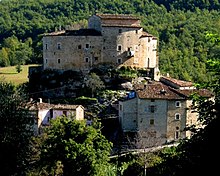
- 1 Fortress of Arquata, via della Rocca, ☎ 39 0736 808247, 39 0736 809122.
 € 2.50 per person (the cost includes the guided tour lasting about 20-30 minutes) (July 2015).
  10:30-12:30 16:00-18:00. The fortress is a mighty fortified military architecture from the Middle Ages, made of sandstone. It stands isolated in the area north of the urban center of Arquata and with its towers dominates and watches over the upper Valle del Tronto and the Salaria. It was erected as a stronghold in charge of controlling the territory, with tactical and defensive functions. The construction of the garrison began between the eleventh and twelfth centuries and lasted until the fifteenth in order to improve, increase and strengthen its defense capabilities. To the primitive settlement, consisting of the hexagonal tower, were added: the tower of the keep with a square base, facing north, between the fourteenth and fifteenth centuries, and the circular base tower on the south-west side, of which the foundation walls. The wall enclosure guaranteed safety to the inhabitants of the town when they took refuge inside. At the Archive of Norcia documents are kept describing the weapons and parabolic-fired artillery pieces that the Arquatana garrison was equipped with. In the inventory we read: "" A two-piece long bombard supplied and shod with cippas, four plates and wedges, a longa spear or two-piece ciarabactana supplied with a cippo and a horse, a half-piece bombard with a lu cippo, shod with a plate, and wedge de iron and cippus supplied, a large bomb without a stone with four plates and other bombards and bombards. " Over the centuries, its structure has benefited from various restoration interventions. The first took place in 1564, authorized by the municipality of Norcia. A second was necessary, in the year 1703, when a violent earthquake damaged the structures of the fortress. Still, in the nineteenth and twentieth centuries, further compensatory works have taken steps to restore the surrounding walls and towers. A multipurpose room has been created within the area circumscribed by the walls. This fortress is also known by the name of Queen Giovanna Castle for the legend that binds it to the figure of the sovereign who made it her residence in the years between 1420 and 1435. At that time the fortress was under the domination of the Kingdom of Naples and the queen was probably Giovanna II of Naples, of the Anjou dynasty. According to tradition, she loved to invite the young shepherds of the valley to her room and with them she entertained and lay during the night and, if dissatisfied, had them hang on the tower, pronouncing their end. According to tradition, the ghost of the noble guest still roams the fortress today.

- 2 Gate of Sant'Agata. It is the only medieval gate that has survived to this day. Arquata was enclosed within the surrounding walls that surrounded the urban center. The gates allowed the access roads to enter the town. This door gave entrance to the road that connected Arquata with the hamlet of Spelonga passing through Colle Piccione. The factory is hidden among the vegetation, it is reached via a staircase which is accessed from the SP129, at the height of the town. In its vicinity, the remains of the walls that surrounded the village can still be seen today. Well preserved, it is made up of irregular sandstone blocks. The two buildings, of simple architecture, rise with different heights. In the round arch of the lower building, where the door was hinged, there are two coats of arms of the sixteenth century. One represents the symbol of the Nursin family of the Quarantotto and has the shape of a shield with «the bas-relief of an eagle staring at a moving sun from the left corner of the shield itself.»The other shows sculpted«a Ghibelline crenellated formwork, with a central tower and a left-hand side that comes out from the base of the tower and holds a high sword on the pole". Probable coat of arms of the Passerini family of Norcia.
- Church of the Santissima Annunziata. free entry. Seat of the parish of Arquatana, it is located along the road that leads to the fortress. Its simple and essential architectural style is decorated with an important carved sandstone portal. The interior is made up of a single room, adorned with wooden altars, a choir loft, the canvas of the Annunciation of the sixteenth, a work of particular value, placed on the back wall and the polychrome wooden crucifix.

- 13th century polychrome wooden crucifix. free entry. The most valuable historical furniture of the church of the Santissima Annunziata is the Polychrome wooden crucifix dating from the second half of the 13th century. Resting on a capital, it is known for being considered the oldest sacred statue in the Marche region. Probably the work of the Spoleto school, it has lines and chromatic characteristics that clearly trace the style of Byzantine art. It has a thickness of about 20 cm and for its measures it can ideally be placed in the center of a square of 145 cm per side. It was chiseled by two friars of the Benedictine Order, such as: Raniero is Bernard, who signed it at the base. The inscription reads: «... TER RANIERI DOM ... R ... DUS T AIDA ... NU TP SU", Interpreted as:"frater Ranieri dominus corpus fecit (or pinxit) frater Berardus aidavit"And translated:"Brother Raniero chiseled (or painted) the body of the Lord, Brother Berardo helped him". It proposes the iconography of a rigid Christ, crucified with outstretched arms and parallel lower limbs. An embossed silver crown was added to the Savior's head in 1855 with the inscription: «ARQUATA COLERAE DISEASE SERVATA SALVATORI HIS D.D. 1855», An ex voto of the residents who wanted to thank their patron in the year in which the country was preserved from victims during the cholera epidemic that had spread. The work comes from the Ascoli church of San Salvatore di Sotto and was transported here by the Arquatani who, in 1860, stole it from Ascoli during one of the clashes with the city. The restoration of 1973 gave it back the vivid light of the colors of the pictorial coating. Particularly revered by the Arquatans, on the first Sunday of September every year, it accompanies the solemn procession of the patronal feast.

- 3 Shroud of Arquata del Tronto (at the Church of San Francesco in Borgo d'Arquata). free entry. The Shroud of Arquata, permanently exhibited in its protective case, is located inside the liturgical hall of the church of San Francesco. It is a faithful reproduction of the sacred linen, a: "EXTRACTVM AB ORIGINAL», (Ie extracted from the original), which was compared with the Turin relic in 1655 and 1931. It was found in the 17th century during the restoration of the church, kept in an urn, hidden in the back of an altar niche. It is accompanied by an authentication certificate signed by Guglielmo Sanza, episcopal chancellor, and Paolo Brizio, bishop and count of the Piedmontese city of Alba. Probably the Papal State chose to entrust this copy to the Franciscan friars who lived in this remote place to preserve a sort of "security copy" of the other which at the time was in the possession of the House of Savoy. There have been few exhibitions in the past, the last time at the time of the Second World War. In 2015, the Radiation Applications Development Technical Unit of the Frascati Research Center of ENEA, the CNR, the Academy of Fine Arts in Rome and the Electronic Engineering Department of the University of Rome Tor Vergata published the result. of the multidisciplinary studies performed on this copy.
- Immanent Art Museum, Via Roma 1, ☎ 39 0736 809556, 39 339 4483692. Private museum. It is advisable to establish a contact to agree on the visiting time. The exhibition space was set up in the center of Arquata in 1990 by Diego Pierpaoli, a leading exponent of the current of Immanentism, an artistic movement born in 1973. Another museum area is located in Villa Papi, an elegant residence, surrounded by the park that houses bronze sculptures and other creations of the artist.
Events and parties
- 1 At the queen's court, Piazza Umberto I, ☎ 39 0736 808247, 39 0736 809122. 19 August. Historical re-enactment in fifteenth-century costume of a medieval outdoor banquet, set up in Piazza Umberto I, in the historic center of the town of Arquata. It was established by the local municipal administration to commemorate the stay of Giovanna d'Angiò, at the fortress, in the first half of the 15th century. The event begins in the afternoon with "The Queen's Descent", that is the parade of many figures who, from the Rocca, walk through the narrow streets of the village and reach the town square. The parade order is opened by the musicians who, with trumpets and drums, precede the arrival of the sovereign. The queen is accompanied by her entourage of pageboys, who support the long train of the dress, and ladies of the court. Followed by the notables, with the insignia and the banner of the municipality, the bridesmaids, the armigers, the archers, the shepherds and the flag-wavers who, in the area of the square, will demonstrate their ability in handling their banners giving life to picturesque choreographies . Then begins the outdoor dinner presided over by the castellana. The menu is based on dishes that follow the recipes of medieval cuisine. All diners are entertained by musicians, dancers and artists.
- 2 The Night of the Mysteries, Park of the Rocca di Arquata, @[email protected]. free entry. August 17th. The event is located in the green park surrounding the Arquatana fortress. For the occasion, a reproduction of a military camp is set up which offers characteristics and peculiarities typical of the medieval age. To populate it there are jugglers, knights wearing armor and other figures in period costume with whom guests can interact with yokes, challenges and archery. During the evening it is also possible to visit the interior of the Rocca.
What to do
The activities that can be practiced differ according to the seasons.
- Excursions. During the hottest periods it is possible to follow paths and hiking trails to be tackled by bike, mountain bike or on foot, to be chosen from different degrees of difficulty.
- Play sport. In the hamlet of Borgo di Arquata there are sports facilities for playing football, basketball, volleyball and tennis.
Shopping
There are no commercial activities in the country, the closest are located in Pescara del Tronto, Village, Trisungo, Acquasanta Terme, Accumoli and Amatrice.
How to have fun
Where to eat
Average prices
- 1 Camartina restaurant, Camartina hamlet (From the SP 129, at the height of the village of Borgo di Arquata, follow the Camartina direction taking the crossroads that indicate it.), ☎ 39 0736 809261, 39 338 9897531, fax: 39 0736 809631, @[email protected]. Comfortable family-run restaurant. The cuisine is excellent and has trout as a specialty.
Where stay
Moderate prices
- 1 [link not working]Bed & Breakfast "La Casa del Conte", Via Andrea Gallo 6, ☎ 39 348 9137672, 39 331 1758391, fax: 39 0736257475, @[email protected]. Bed and breakfast: 40.00 Euro (per person) Reductions: children 0-4 years free (July 2015). Availability of 3 triple rooms (royal suites) with a great atmosphere. Large balcony of 13 meters, fireplace, TV, safe, anti-intrusion system. Traditional breakfast with local specialties. Animals are not allowed.
- [link not working]Bed & Breakfast "Il Cavallino Bianco", Via Andrea Gallo 6, ☎ 39 348 9137672, 39 331 1758391, fax: 39 0736257475, @[email protected]. Bed and breakfast: 35.00 Euro (per person). Reductions: children 0-4 years free (July 2015). Structure arranged on a single floor with entrance on the ground floor, is equipped with fireplace, TV, safe, anti-intrusion system. Traditional breakfast with local specialties. Animals are not allowed.
- [link not working]Arquata in 3 D - holiday home, Via Salaria Vecchia, ☎ 39 335 7065966, @[email protected]. € 28 per day for bed and breakfast (July 2015). The house consists of two residential units, arranged on three floors within a single building. "Casa Simonetta": kitchen / living room with fireplace, two bedrooms (double and twin for single use) and a bathroom with shower. "Casa Berardo": kitchen, large living room with fireplace and wood stove, three bedrooms (double and twin with single use), two bathrooms with whirlpool tub, for a total of 10 beds. The house has terraces and a large outdoor garden.
Average prices
- 2 Hotel Ristorante Camartina, Camartina hamlet (From the SP 129, at the height of the village of Borgo di Arquata, follow the Camartina direction taking the crossroads that indicate it.), ☎ 39 0736 809261, 39 338 9897531, fax: 39 0736 809631, @[email protected]. Comfortable family-run hotel, easy to reach. Quiet and reserved, it is ideal for families with children. The cuisine is excellent and has trout as a specialty.
- 3 [link not working]Giovanni Giacomini Alpine Refuge (ANA refuge), Fork of Presta, ☎ 39 0736 809278, 39 347 0875331, 39 347 0875332. Full board € 60.00 (drinks not included), half board € 40.00 (drinks not included), per person. Packed lunch prepared to take on the excursion € 7.00. Children up to three years do not pay, from three to six have a discount of 50%, from six to twelve the discount and 10% (July 2015). Built in 1973, at an altitude of 1560 m a.s.l., it is owned by the National Alpine Association. Managed by Gino Quattrociocchi and Barbara Fiori. Structure equipped with bar, catering and dormitories in autumn. No pets, even small ones, are allowed. Reachable by car. Open every day between June 15th and September 15th. It is open all year round on holidays and days before holidays. In the winter it is always better to contact the managers.
- 4 Colle le Cese Refuge, Forca Canapine, ☎ 39 0736 808102, 39 320 1723752, 39 339 4513189, @[email protected]. The costs of half board vary from € 44.00 to € 58.00; for full board from € 60.00 to € 72.00 per person. Discounts for children according to age groups. It is possible to accommodate animals. School stays are possible with or without hiking activities from € 38.00 to € 50.00 per person (July 2015). The refuge has 38 beds, divided into rooms for two - four people. All rooms are equipped with room services and all the devices for the disabled.
Safety
List of telephone numbers that can be useful during a stay:
- 3 Carabinieri Command Station, Via Roma, 1C (Arquata del Tronto), ☎ 39 0736 809152. Arquata barracks.
- 4 State Forestry Corps, Via Bucciarelli, 11 A Borgo hamlet, ☎ 39 0736 809151, @[email protected]. Seat of the Regional Coordination of the State Forestry Corps - Ancona
- Alpine Rescue Lazio, ☎ 39 348 6131300.
- Alpine Rescue Abruzzo, ☎ 39 340 4500611 (President of the Regional Service), 39 346 5009564 (Alpine Delegate), 39 348 8669675 (Speleo Delegate).
The Ascoli Piceno Alpine Rescue can be contacted via the single national health emergency number 118.
How to keep in touch
Post office
- Poste Italiane Spa Agency of Arquata, Via Roma, 1, ☎ 39 0736 809825.
Around
The territory of the Arquatano, due to its geographical position, allows you to easily and quickly reach (either on foot with trekking routes, by car or other means of transport such as motorcycles or bicycles) many places and nearby scenic locations from which to observe. and experience the mountains that surround it.

- Fork of Presta - In the locality there is the Path for everyone, realized as part of a project of the National Park of the Sibillini Mountains. Il percosro is a comfortable walk through the meadows of Forca di Presta. It starts in front of the Rifugio degli Alpini and extends for about 3 km. Easy and accessible even to people with mobility difficulties. It ends with a wooden walkway resting on the lawn that stops on lookout from which you can see the Laga mountains, on the border with the Abruzzo region, the villages of: Faete, Spelonga, Colle di Arquata, Arquata del Tronto and Amatrice, in the province of Rieti. Usability is limited to periods when there is no snow.
- Mount Carrier - There is the Trekking route from Forca di Presta to the Carrier with a challenging degree of difficulty. From the Forca di Presta pass (1,535 asl) walking a distance of about 10 km (round trip), you reach 2,476 a.s.l. of the summit of the Carrier. The walk lasts approximately 3 hours outward and 2 hours back. Recommended period: from April to November if there is no snow.

- Lake of Pilato - There is the Trekking route from Forca di Presta to Lake Pilato with challenging degree of difficulty. From the Forca di Presta pass (1,535 above sea level), walking for a distance of about 5 km, you will reach 1,947 above sea level. of the share of Lake Pilate. The walk lasts about 2 hours outward and 1.40 hours back. About an hour's walk from the start is the Tito Zilioli Refuge. Recommended period: from April to November if there is no snow.
.jpg/220px-TermeDiAcquasanta(AP).jpg)
- Acquasanta Terme — Centro termale a circa 15 km da Arquata, seguendo la SS4 in direzione Ascoli Piceno. Il paese è rappresentato sulla Tavola Peutingeriana con il nome di Vicus ad Aquas o Pagus ad acquas, è noto soprattutto per la presenza di sorgenti di acqua sulfurea, documentate fin dall'epoca romana. I ruderi delle terme romane, consistenti in una cisterna e due piscine, si trovano nella frazione di Santa Maria del Tronto. Distrutte durante l'epoca barbarica furono ricostruite ad Acquasanta. Carlo Magno visitò il sito nell'800, quando passò nella cittadina per recarsi a Roma per l'incoronazione. Attualmente vi è un moderno complesso attrezzato per cure termali, fisioterapiche e riabilitative in acqua sulfurea. All'interno del centro storico vi sono case del 1500 e la chiesa di Santa Maria Maddalena dove sono custoditi: una tela veneziana del 1600 e un affresco del 1500.
- Castel di Luco — A pochi km da Acquasanta Terme in direzione Ascoli vi è la costruzione fortificata che si eleva sulla sommità di uno sperone di travertino dominando il panorama sulla Salaria e sul fiume Tronto. Conserva ancora oggi la sua immagine di architettura medievale e si distingue per la sua caratteristica forma ellittica. L'elemento bellico più evidente è la torre a scarpa munita di cordone antiscalata e di archibugiere elevata nel XVI secolo. A sud-est vi è la torricina da difesa.

- Norcia — Interessante cittadina umbra che dista circa 30 km da Arquata. Nota per aver dato i natali nell'anno 480 a san Benedetto, monaco che istituì l'Ordine benedettino e patrono d'Europa. Il suo centro storico, in stile rinascimentale, ospita gli edifici più significativi della cittadina, come: la basilica di San Benedetto, la cattedrale di Santa Maria Argentea, la Castellina, (residenza fortificata), il Portico delle misure, il Palazzo comunale. Le sue strade sono scandite dalla presenza di numerosissime attività commerciali che propongono le specialità della norcineria, il locale prosciutto IGP, oltre alle lenticchie di Castelluccio e ai tartufi neri.

_panorama056.jpg/220px-Castelluccio_di_Norcia_(PG)_panorama056.jpg)
- Castelluccio is Piani di Castelluccio — Castelluccio è un piccolo paese arroccato sull'unica altura che domina l'immenso altopiano che si allarga alle falde del versante umbro del monte Vettore, nel territorio della provincia di Perugia. Dista poco più di 35-40 km da Arquata. Il centro si trova a 1.452 m s.l.m. ed ha la particolarità di avere molte scritte sui muri esterni delle case, messaggi affidati alla vernice bianca che le caratterizza, legate alla satira del paese. Per tradizione ha un'economia prevalentemente agricola e dedita alla pastorizia, è conosciuto ed anche famoso per la produzione di lenticchie. Offre un panorama particolarmente suggestivo sui: Pian Grande e Pian Piccolo e Pian Perduto che si estendono per circa 15 km². I Piani sono i luoghi della Fiorita, ossia la sterminata fioritura di papaveri, fiordalisi, margherite che colora l'altopiano tra la fine di giugno e l'inizio di luglio.

- Ascoli Piceno — Sede del capoluogo di provincia, dista meno di 30 Km da Arquata percorrendo la SS4 in direzione Ascoli. È nota come la Città delle cento torri. Il suo centro storico è famoso per avere case, palazzi, chiese, ponti e torri elevate in travertino. Qui, la storia e gli stili architettonici hanno sedimentato il loro passaggio dall'età romana al medioevo, fino al rinascimento. Artisti come Cola dell'Amatrice, Lazzaro Morelli, Carlo Crivelli, Giosafatti ed altri valenti scultori, lapicidi, pittori hanno lasciato un segno del loro talento. Accoglie una tra le più belle piazze d'Italia: Piazza del Popolo, centro di vita culturale e politica, incorniciata dai portici a logge, Palazzo dei Capitani e il Caffè Meletti. Ogni anno nel mese di agosto vi si tiene la Quintana, rievocazione storica in costume con corteo e competizione di sei cavalieri in lizza per la conquista del Palio.
- Amateur — Cittadina in provincia di Rieti a circa 20 km da Arquata, si raggiunge percorrendo al SS4 in direzione Roma e girando al bivio a destra che la segnala. È sede polo agroalimentare del Parco nazionale del Gran Sasso Monti della Laga e foamosa per il Sugo all'Amatriciana. Of particular interest are the civic tower of the thirteenth century, the church of Sant'Agostino with a late Gothic portal and bell towers. The interior is rich in frescoes among which the Annunciation and the Madonna with Child and Angels stand out. The Sant'Emidio church, dating back to the fifteenth century. The "Nicola Filotesio" Civic Museum of sacred art set up in the church of Sant'Emidio.
Itinerari
- Il grande anello d'Arquata — Percorso trekking, Il grande anello d'Arquata. Difficoltà E. Il cammino è la tratta del Grande anello dei Sibillini che attraversa il territorio arquatano. Il suo percorso coincide, parzialmente, col Sentiero dei Mietitori e si sviluppa fra Colle di Montegallo e Colle le Cese. È tra i più panoramici della catena sibillina. Dalla piazza di Arquata si segue la strada che conduce alla Rocca, da qui il percorso è segnalato con le bandierine del CAI. Il cammino s'interna tra i boschi della pineta alle falde del Vettore, ha tratti pianeggianti, attraversa fondi ghiaiosi e piccoli corsi d'acqua. Da Arquata raggiunge il Rifugio Giovanni Giacomini a Forca di Presta dove il sentiero costeggia la dorsale di Macchialta e si arriva al Rifugio colle le Cese.
Useful information
- 5 Municipality of Arquata, Piazza Umberto I, ☎ 39 0736 809122, @[email protected].
- 6 [link not working]House of the Sibillini Mountains Park, Borgo hamlet, ☎ 39 0736 803915, @[email protected]. It is based at the Centro Due Parchi
- 7 Center of the Two Parks, Borgo hamlet, ☎ 39 0736 803915, fax: 39 0736 809921, @[email protected]. from June to September, Mon-Sun 9: 30-12: 30 and 16: 00-19: 00. It operates in the area as a Training and Permanent Education Center. You can contact this facility for information on the area, to learn about trekking and hiking trails, mountain bike trails and more. Reservations are made for excursions and activities proposed by the Park Guides. Furthermore, it is possible to know the rules of conduct to observe in the protected area and to purchase information material on the Sibillini National Park
- [link not working]Cime Azzurre Cooperative, Via Mattatoio, 2 Borgo di Arquata, ☎ 39 0736 804780, @[email protected]. Environmental Education Center.
Other projects
 Wikipedia contains an entry concerning Arquata del Tronto
 Commons contiene immagini o altri file su Arquata del Tronto