| Trisungo | ||
 | ||
| State | Italy | |
|---|---|---|
| Region | Marche | |
| Territory | Upper Tronto Valley | |
| Altitude | 601 m a.s.l. | |
| Inhabitants | 176 (2001 census) | |
| Name inhabitants | Trisungani | |
| Prefix tel | 39 0736 | |
| POSTAL CODE | 63040 | |
| Time zone | UTC 1 | |
Position
| ||

Trisungo is a fraction of the municipality of Arquata del Tronto, in the province of Ascoli Piceno, of the region Marche.
To know
The small town stretches along the edge of the old consular Salaria, on the right bank of the Tronto river and enjoys the view of the town and the Rocca di Arquata del Tronto. It is identified by historians with the locality of Ad Centesimum, located on the left bank of the Tronto river. It is one of the statio reported byItinerarium Antonini which was located 99 km from Rome on the Consolare Salaria, located between stationes of Vico Badies, the current Fonte del Campo in the province of Rieti, is Asclo the city of Ascoli Piceno.
The toponym would result from the variation of the words: tres is jungo, that is, of three and of joint, suitable to indicate the point where the three roads that crossed the country met, namely: the vorsus, direction Village, the via Salaria and the road that led to ColleThe small town was divided into three districts or districts: Contrada Ponte, the oldest, Neighborhood is Trisungo. In Rione Ponte there is the oldest residence in the town, discreetly preserved. It is distinguished from the rest of the houses for its particular shape of the facade which has a winged face of an angel on an architrave, an owl holding another architrave, a frescoed niche above the entrance and a walled shield engraved with the date 1515.
Geographical notes
Trisungo rises at 601 m a.s.l. in the Upper Tronto Valley. Squeezed by high peaks including that of Mount Vector. The environmental context is of important importance and is in fact inserted within two protected areas, the Gran Sasso and Monti della Laga National Park and the Monti Sibillini National Park. The area is rich in springs, green meadows, large wooded areas and high altitude pastures.
When to go
It can be visited in every season of the year having a typical mid-mountain climate with mild springs and summers and winters with some snowfall.
How to orient yourself
The territory of the town of Trisungo is crossed in an east-west direction by the SS4 Salaria and the course of the Tronto river which divide the chain of mountains of the Laga from the chain of Sibillini mountains.
The roads branch off from Salaria that intersect the municipal territory and allow you to reach all the hamlets and the most famous mountain resorts in the area:
- Provincial Road 89 which leads to the hamlets of Village, Piedilama, Pretare is Fork of Presta, a pass shared with the municipality of Norcia.
- Provincial Road 20 which leads to the hamlets of: Faete, Spelonga is Colle.
How to get
By plane
The nearest airports are:
- Raffaello Sanzio of Falconara (Marche),
- Free of Pescara (Abruzzo),
- Fiumicino is Ciampino From Rome,
- Umbria International Airport of Perugia.
By car
Highways:
- A14: exit San Benedetto del Tronto.
Ordinary viability:
- SS4 Salaria
On the train
The nearest railway station is that of Ascoli Piceno.
How to get around
The most comfortable means of transport for getting around the area are: cars, motorcycles and bicycles. Inside the inhabited center it is easy to get around on foot, the streets and alleys are in good condition and take on moderate slopes and climbs, all accessible even to people with disabilities.
What see
- Church of Santa Maria delle Grazie. In the sixteenth century, in the hamlet, the church dedicated to San Giacomo already existed, which became too small to contain the entire population during functions. The inhabitants thus felt the need to build a new, larger religious building. The 25 Petrucci families, residing in the town, wrote a petition to the canons of San Giovanni in Laterano to obtain consent to build a new church on the other bank of the river, verbatim: It was inconvenient for the people of Rione Ponte to participate in all religious functions, especially in winter when the abundance of water made it more difficult than ever for the elderly, children and pregnant women in the river. In the year 1580 the order was granted to build a church dedicated to Santa Maria delle Grazie which was completed in 1585. The building, of modest size, has a simple and unadorned façade. The portal is from the 16th century with some decorative elements from the 15th century. The pointed bell tower, the portal and the altar, dedicated to the Madonna delle Grazie, are made of ashlars of sandstone, typical of the place. The church develops in a single nave covered by a gable roof. On the sides of the entrance two rectangular windows give light to the environment. Its interior was decorated with mural paintings that date back to the 16th and 17th centuries, but were damaged by a flood of the Tronto river in the 18th century, when the church underwent the first restorations for this need. In 1832, a niche was dug on the left wall to house a noble tomb. Another niche was opened for the wooden altar dedicated to Our Lady of Sorrows and the Dead Christ. Another important restoration took place in 1932, when the seven frescoes covered after the flood of the river were found. Worthy of interest is the one, (central of the right wall), depicting Saint Anthony the Abbot, blessing, recognizable by the tau on the yellow pilgrim, a symbol that during the Middle Ages identified the holy hermit, from the bell on the crosier and from the snout of the pig that can be seen below. The background of the painting depicts a rural landscape with flocks, sheep and shepherds, flights of birds and a church at the top right. On the sides two candlesticks and at the bottom under the frame the inscription: TEMPORE REVENNI PIETRAGNILI PETRUTTII. Next to Saint Anthony the Abbot, there is the fresco of Saint John the Baptist with the inscription: "THIS OP. A. F. FARE JOVAN VINCENZO DE IOVANO P. VOTE 1595". Other frescoes depict the Madonna with Child and three saints: St. Augustine, St. Peter and St. Paul.
- The Milestone of Trisungo. In the stretch of the Tronto river that crosses the hamlet, a Roman relic was found in 1831 consisting of a travertine column rock dated 16 BC, in the immediate vicinity of the location indicated as Ad Centesimum in the card of Itinerarium Antonini, where it is now leaning against the wall of Casa Lauri. The milestone of the Roman Via Salaria documents a Senato Consulto, dated 22 BC, with which the emperor Augustus arranged a re-adaptation of the Salaria along the Tronto Valley. Defined in the list of notable monuments of the Ascoli area by Gabrielli as: "... Roman column from the time of Augustus, with inscription". The cippus was usually made up of a large natural stone in its simplest expressions, this, however, is a column-shaped artifact, 70 cm high, and with a slightly smaller section. It had the purpose of expressing the progressive distance in kilometers from the point of origin of the road, in this case of the Salaria whose origin was Rome. On the milestone, in addition to the distance, the name of the emperor or magistrate who had restored or commissioned the construction of the road on which the stone was placed was also carved. The inscription can support the hypothesis of the coincidence of the place Ad Centesimum was just that.
| "IMP. CAESAR. DIVI F. AUGUSTUS COS. XI TRIBV. POTEST VIII X.S.C. XCVIIII " |
| (The inscription on the cippus) |
Events and parties
- Patronal feast.
 September 8.
 - 1 [link not working]Brown what a passion, ☎ 39 320 8082846, 39 0736 809122 , 39 0736 808247. last weekend of October. Food and wine festival dedicated to brown, a variety of chestnuts typical of the area of the Monti Sibillini and Monti della Laga parks.
What to do
The town offers the possibility to move to the nearby towns and to the urban centers of the hamlets with easy road connections. There are also hiking trails that, crossing the mountain territory, allow long walks through the green vegetation that surrounds the town, which can also be practiced with mountain bikes and bicycles. The activities that can be practiced differ according to the seasons.
- Excursions. During the hottest periods it is possible to follow paths and hiking trails to be tackled by bike, mountain bike or on foot, to be chosen from different degrees of difficulty. During the winter it is possible to practice skiing in the nearby hamlet of Forca Canapine.
Shopping
How to have fun
In the summer season there are many opportunities for recreation throughout the territory of the municipality with the programming of numerous events related to historical reenactments and patronal festivals that entertain visitors with musical evenings or outdoor festivals.
Where to eat
Average prices
- 1 Ristorante Pizzeria Il Ponticello, Trisungo hamlet, ☎ 39 0736 809728, @[email protected]. Convenient to reach, along the Via Salaria, it has 2 restaurant rooms and ample parking. Typical local cuisine with local products.
Where stay
Moderate prices
- [link not working]B&B Trisungo, Fraz. Trisungo 142, ☎ 39 0736 803901, 39 347 1540109, @[email protected]. Cozy structure, recently restored, which has 4 rooms overlooking the medieval fortress of Arquata del Tronto, equipped with heating, air conditioning and free WiFi. Small and medium-sized pets are allowed.
Safety
- Pharmacy
- 2 Dr. Palmarocchi, Via Salaria, ☎ 39 0736 809219.
List of telephone numbers that can be useful during a stay:
- 3 Carabinieri Command Station, Via Roma, 1C (Arquata del Tronto), ☎ 39 0736 809152. Arquata barracks.
- 4 State Forestry Corps, Via Bucciarelli, 11 A Borgo hamlet, ☎ 39 0736 809151, @[email protected]. Seat of the Regional Coordination of the State Forestry Corps - Ancona
- Alpine Rescue Lazio, ☎ 39 348 6131300.
- Alpine Rescue Abruzzo, ☎ 39 340 4500611 (President of the Regional Service), 39 346 5009564 (Alpine Delegate), 39 348 8669675 (Speleo Delegate).
The Ascoli Piceno Alpine Rescue can be contacted via the single national health emergency number 118.
How to keep in touch
Around
From the hamlet of Trisungo it is easy to reach many well-known localities in the area, including:
_012.jpg/220px-Rocca_di_Arquata_del_Tronto_(AP)_012.jpg)
.jpg/220px-Oratorio_della_Madonna_del_Sole_-_Capodacqua_(Arquata_del_Tronto).jpg)
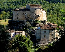
- Arquata del Tronto - Seat of the municipal capital where there are: the church of the Santissima Annunziata, which welcomes the 13th century polychrome wooden crucifix and the Fortress of Arquata, also known as Queen Giovanna Castle, is a fortified complex from the Middle Ages, which can be visited in all its rooms.
- Capodacqua - The hamlet is a few km from the Pescara city center, and can be reached by taking the Provincial Road 64 towards Forca Canapine. Inside the village there is to visit the Oratory of the Madonna del Sole, a small building with a richly frescoed octagonal plan, dedicated to the Virgin, built in 1528 and originally attributed to the creative genius of Cola dell'Amatrice. For its stylistic features it represents a unicum which stands out from all the other buildings in the Apennine area of central Italy.

_panorama056.jpg/220px-Castelluccio_di_Norcia_(PG)_panorama056.jpg)
- Forca Canapine - Along the Provincial Road 64 in the direction of Forca Canapine, you go up in altitude and arrive at the pass that divides the Arquatano area from the municipality of Norcia. The town is the starting point for other excursions. From the pass you can go down towards the Piani di Castelluccio, Castelluccio and Norcia. Or you can choose to travel by car (or other means of transport) or to walk through the paths that lead to Fork of Presta.
- Acquasanta Terme - Thermal center about 15 km from Pescara del Tronto. It can be reached by proceeding towards Ascoli Piceno from the SP64 and then from the SP129 to reach the SS4. Or from the SP64 take the SS685 and follow the direction Ascoli. Inside the historic center there are houses from the 1500s and the church of Santa Maria Maddalena. A few kilometers from Acquasanta, always in the direction of Ascoli, is Castel di Luco, a fortified medieval castle built on the crest of a travertine spur. From its position it observes the panorama of the Salaria and the Tronto river.
Useful information
- 5 Municipality of Arquata, Piazza Umberto I, ☎ 39 0736 809122, @[email protected].
- 6 [link not working]House of the Sibillini Mountains Park, Borgo hamlet, ☎ 39 0736 803915, @[email protected]. It is based at the Centro Due Parchi
- 7 Center of the Two Parks, Borgo hamlet, ☎ 39 0736 803915, fax: 39 0736 809921, @[email protected]. from June to September, Mon-Sun 9: 30-12: 30 and 16: 00-19: 00. It operates in the area as a Training and Permanent Education Center. It is possible to contact this structure for information on the area, to learn about trekking and hiking trails, mountain bike trails and more. Reservations are made for excursions and activities proposed by the Park Guides. Furthermore, it is possible to know the rules of conduct to observe in the protected area and to purchase information material on the Sibillini National Park
- [link not working]Cime Azzurre Cooperative, Via Mattatoio, 2 Borgo di Arquata, ☎ 39 0736 804780, @[email protected]. Environmental Education Center.