| Treviso | ||
 | ||
Coat of arms  | ||
| Salutation | Joyful and loving brand | |
|---|---|---|
| State | Italy | |
| Region | Veneto | |
| Territory | Treviso area | |
| Altitude | 15 m a.s.l. | |
| Surface | 55.58 km² | |
| Inhabitants | 83.062 (2013 estimate) | |
| Name inhabitants | trevisani, trevigiani, trivigiani (rarely used) | |
| Prefix tel | 39 0422 | |
| POSTAL CODE | 31100 | |
| Time zone | UTC 1 | |
| Patron | Liberal saint | |
Position
| ||
| Tourism site | ||
| Institutional website | ||

Treviso is a city of Veneto.
To know
Formerly a Roman municipality with the name of Tarvisium, flourished in the Middle Ages and under the rule of the Republic of Venice. The heart of the city is the Piazza dei Signori, around which there are numerous buildings, including the "Bell Tower" and the "Palazzo dei Trecento". Giuseppe Mazzotti defined Treviso "the most frescoed city in Italy".
Geographical notes
Treviso is located on the middle Venetian plain, about 25 km north of Venice. It is crossed by the Sile River, the longest resurgence river in Europe.
When to go
Cities to visit in every season, enjoying every corner, discovering characteristic views, breathing in the lively city life.
Background
The roots of Treviso date back to the Bronze Age, during which the Paleoveneti, probably of Illyrian origin, settled on the very slight hill today corresponding to Piazza Sant'Andrea.
Subsequently conquered by the Romans, in 49 BC. obtained the title of Municipium.
After the fall of the Roman Empire, it was under the dominion of the Goths, the Lombards and then the Carolingians.
In 911 it was devastated by the Hungarians, but it rose again and in 1164 it was recognized as a free municipality by Federico Barbarossa.
After various lordships, in 1339 it passed under the dominion of Venice, and from that date its fate followed.
The origins
In ancient times people chose to preferably live near a river, because this made it possible to trade and communicate more easily, moreover there was water and food available, but above all the river represented a natural defense against any invasions. Even the ancient inhabitants of Treviso chose the area of the river Sile for these reasons, attracted also by the products that the nearby woods provided. The first traces of settlement in the historic center can be found on three hills, because elevated places close to rivers were rightly preferred. The first findings, of huts with a beaten clay base, are estimated to be between 1500-1400 BC. C., the first village should have risen on the top of today's Sant'Andrea hill, about 18 meters high and protected by water. Subsequently the inhabitants expanded on the other hills, identifiable in the current Piazza Duomo and Piazza dei Signori. The village then acquired more and more importance because of its possibility of trade.
The Roman era
At the time of the Romans, the territory was divided according to the Roman centuriation and in 49 BC. C. Treviso became municipium. In this period, the main streets of the city were built, the cardo and the decumanus, and the city continued to intensify transport and trade with the neighboring cities, especially with the city of Altino, then an important seaport on the Adriatic. The ancient one passed through Treviso via Postumia, which connected Genoa to Aquileia.
The communal age
From the second half of the eighth century, Treviso also became one of the most important mints of the time. In the twelfth and thirteenth centuries the city became more and more prestigious, extending its borders. He also became half of illustrious personalities, including Dante and Tomaso da Modena who were attracted by the desire for beauty that was breathed in this city: new churches and palaces were built and embellished or decorated in a surprising way, Treviso was also called "Urbs Picta ”, That is, painted city.
The era under Venice
Over the years the river Sile increased its importance: the course of the waters was exploited by building many mills, the activity of which will make the city "the granary" first of the surrounding territories, then of the Republic of Venice: the city was understood by this last in 1339 becoming a fundamental center. When in 1500 the League of Cambrai decided to fight the lagoon city, Treviso was fortified by entrusting the famous Fra 'Giocondo with these works, succeeded by Lorenzo di Ceri and Bartolomeo d'Alviano. The appearance of the city changed by building the walls that still surround the historic center today and three gates were built: Porta Santi Quaranta, Porta San Tommaso and Porta Altinia. The Republic of Venice depended on Treviso not only for the agricultural production of the flour produced by the Sile mills, but also for the wood, coming from the Cansiglio and Montello woods, destined for the construction of ships and transported by river.
From Napoleon to the Two Wars
In the nineteenth century with Napoleon and the Austrians many convents and churches were used as warehouses or barracks, causing enormous damage to the artistic heritage. A further catastrophe for the palaces of the painted city and for the churches was caused by the two world wars and above all by the bombing of 7 April 1944.
How to orient yourself
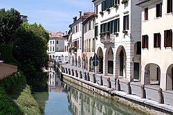
Assuming you are coming from the railway station on Piazzale Duca d'Aosta, to reach the center you will have to travel for about 300 meters along the Via Roma that crosses the Polveriera canal.
The artery then changes its name to Corso del Popolo which, after crossing the river Sile on the San Martino bridge, ends in Piazza della Borsa. A few steps in via XX Settembre and you reach Piazza dei Signori, the center of Treviso.
Piazza dei Signori is crossed by Calmaggiore, the ancient Roman thistle that leads to Piazza Duomo
How to get
By plane
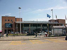
- 1 Treviso Airport (Canova), via Noalese 63 / E (5km southwest of the city center). Here Ryanair makes national and European connections.: A bus service operated by ACTT, shuttles betweenairport and the center ending at the railway station.
From here it is also possible to take a taxi whose service is carried out by Radiotaxi.
By car
Highways
 Highway Serenissima (Turin-Trieste): Preganziol junction
 A27 motorway of Alemagna (Venice-Belluno):
Coming from the south (Venice), exit at Treviso Sud (km 13.4) then take the road Treviso Mare to the west.
Those coming from the north (Conegliano), exit at Treviso Nord (km 22.6) (Lancenigo in the municipality of Villorba), take via Piave towards the south-west and continue for about 3.7 km up to the Pontebbana (SS 13). From here, towards the south, after 3.5 km you arrive at the Porta di San Tomaso.
Regional roads
 State road 13 Pontebbana (coming from Venice-Mestre to the south and from Conegliano to the north). The section from Mestre to Treviso is called Terraglio;
- Regional road 53 Postojna (coming west from Cittadella [with the street name Castellana] and east from Portogruaro);
- Regional road 89 Treviso-sea (coming from Jesolo);
- Regional road 348 Feltrina (coming from Feltre);
- Regional road 515 Noalese (coming from Padua);
On the train
In Treviso there is a railway station, the city is directly connected by train to Venice, Trieste, Milan, Padua, Vicenza, Pordenone, Udine, Gorizia, Belluno, Vienna and other important cities.
How to get around
By bike
The “TVBike Treviso” bikesharing service is active for getting around by bicycle. There are 16 stations with 168 columns and 93 circulating bicycles. The service is subject to charges.
By public transport

The Treviso urban transport network is a local public transport system of the city of Treviso and its urban area, also including the neighboring municipalities (Casier, Preganziol, Silea, Carbonera, country, Fifth, Villorba, Ponzano, Farmhouse, Povegliano), handled by Brand mobility. It consists of 13 lines that cover the entire city center, plus school reinforcements when needed.
All lines make connections through the downtown area, the hub of the service, and connect at Treviso Central Station (except Line 12, Villorba circular). The city center, within the walls, can be divided into two sections: 8 lines (4, 6, 8, 9, 11, 21, 55, 61) cross the western part of the city, passing through Piazza Vittoria, Piazza Pio X, Piazza Duomo, Porta Santi Quaranta and Porta Calvi; 4 lines (1, 3, 7, 10) cover the east part inside the walls, serving Piazza Matteotti, Piazza San Leonardo, Piazzale Burchiellati, Piazza dei Signori, Piazza Borsa, Corso del Popolo.
Service


Public transport is managed by the company MOM-Brand Mobility (Until 31 December 2013 the service was managed by ACTT).
The poles (inherited from ACTT) that distinguish the stops have a characteristic rounded shape at the top, and are blue in color; the main stops of each line are shown on them. Each stop is identified by a numerical code and by a name that defines its position. The livery of the buses varies according to the age of the vehicles: the most antiquated have the orange color, while the more modern and recent buses are distinguished by the emerald green color. Each line is identified by a number, from 1 to 61, and by the destinations to which it leads.
Travel tickets
They can be purchased at various outlets in the area and on board the bus. In addition, tickets can also be purchased via SMS since 2013.
Monthly or annual passes are available, valid for ordinary, students and workers, every day of the year.
Lines

The following lines are covered:
- 1 Hospital - Railway Station - Piazza Matteotti - Santa Maria del Rovere - Sant'Artemio - Charity - Catena - Villorba
- 21 Castagnole - Town - P.le Pistoia - Piazza Pio X - Railway station - San Lazzaro - Frescada - San Trovaso - Preganziol
- 3 Treviso Railway Station - Fiera - Silea - Lanzago - Cendon - Sant'Elena
- 4 Casier - Sant'Antonino - Treviso - Fountains - Charity
- 55 Santa Cristina - Quinto di Treviso - Canizzano - Sant'Angelo - San Zeno - Railway station - Santa Bona - Merlengo
- 6 Railway Station - Piazza Duomo - San Giuseppe - Airport - Quinto di Treviso
- 61 Treviso - San Pelajo - Ponzano - Paderno - Sant'Antonio / Barrucchella Camalò
- 7 S.Artemio - Stadium - P.Matteotti - Railway Station - San Lazzaro - San Zeno
- 8 P. Vittoria - Railway Station - San Lazzaro - Frescada - San Trovaso - Sambughè
- 9 San Paolo - San Liberale - Viale Europa - Piazza Pio X - Railway Station - Dosson - Conscio / Preganziol
- 10 Railway station - Selvana - Carbonera - Pezzan / Mignagola
- 11 Padernello - Town - P.le Pistoia - Railway station
- 12 Charity - San Sisto - Catena - Castrette - Charity
- Note


- Depending on the route, the lines can have one route (Station - Terminus - Station; example: Station - country - Railway station, Line 11) or two or more routes (Terminus - Station - Terminus; example: S.Paolo - Station - Dosson any Conscious or Preganziol, Line 9).
- All lines terminate at the Railway station, except Line 12 (Circular of Villorba). There are 4 different terminus stops (in Via Roma for Lines 1, 4, 7, 8, 9, 11, 21, 55; in V.le Duca d'Aosta for Lines 7, 8, 21, 55; in V .le De Gasperi for Line 6; in V.le Fratelli Bandiera for Lines 1, 3 /, 4, 9, 10, 61)
- The city center, within the walls, can be divided into two sections: 8 lines (4, 6, 8, 9, 11, 21, 55, 61) cross the western part of the city, passing through Piazza Vittoria, Piazza Pio X, Piazza Duomo, Porta Santi Quaranta and Porta Calvi; 4 lines (1, 3, 7, 10) cover the east part inside the walls, serving Piazza Matteotti, Piazza San Leonardo, Piazzale Burchiellati, Piazza dei Signori, Piazza Borsa, Corso del Popolo.
- THE extensions or any deviations of each line are usually indicated by the / (crossed out).
- There Line 3 circulates once a day along Via Treviso in Silea; all other routes pass through Lanzago how 3/.
- The only one evening service it is operated by Line 6 to and from the airport (until 10:35 pm every day).
- There Line 12 it does not pass through Treviso, but follows a circular route between Carità, S.Sisto, Catena and Castrette in the municipality of Villorba.
MOM's Treviso urban service also includes the connection to and from Treviso Airport.
The structure is served by buses on Line 6, which connect the airport with the railway station and the historic city center, passing through Via Noalese, San Giuseppe and Miani Park in the Eden Village [10]; in the opposite direction, the vehicles continue towards Quinto Fronte Chiesa (Line 6) or Quinto Via Ciardi (Line 6 /); during peak hours, some trips are extended to Località San Cassiano. Line 6 is also active in the evening, until 22:35, limited in front of the airport.
In addition, the MOM Extraurban Lines 101, 102 and 103 pass through the airport.
By taxi
- Radio Taxi Cooperative of Treviso (CO.TA.TRE), ☎ 39 0422 431515, 39 199 484 950, fax: 39 0422 432022, @[email protected].
 From the historic center or from the train station to the airport there is a fixed rate of € 15.00.
  Mon-Sun 04: 00-01: 30. In addition to the classic cars, 9-seater minibuses are also available.
Where they park:
- Independence Square a few steps from Piazza dei Signori;
- Treviso Central next to the station;
- Treviso hospital;
- Treviso Airport.
What see
- 1 Piazza dei Signori, Piazza dei Signori. The living room of Treviso.
- 2 Duomo (Cathedral of St. Peter the Apostle), Piazza Duomo (overlooks the Piazza del Duomo). it is the main place of worship in the city of Treviso and the seat of the diocese of the same name. Its origins date back to the early Christian age (6th century). In 1760-82 the building was rebuilt in neoclassical style by Andrea Memmo and Giannantonio Selva, following the project of the castle architect Giordano Riccati. The facade dates back to the first half of the nineteenth century, the work of Francesco Bomben and Gaspare Petrovich.
- 3 Church of San Nicolò, Via San Nicolò.
- 4 Church of San Francesco, Via San Francesco.
- 5 Church of Santa Maria Maggiore (Madona Granda).
- 6 Monumental Complex of the Churches of Santa Lucia and San Vito, S. Vito square, @[email protected].
- 7 Athenaeum of the Municipal Library of Borgo Cavour, Borgo Cavour 20. Mon-Fri 9: 00-13: 00; 14: 30-18: 00. Superb room embellished with wooden stalls from the church of the Madonna del Monte.
- 8 Loggia of the Knights, Via Martyrs of Liberty. Elegant and slender building with a quadrilateral plan, the only one of its kind in Europe. Made of brick and surmounted by a tile roof.
- 9 Buranelli canal, Buranelli porch. In this place women came to wash clothes
- 10 The complex of Santa Caterina (Museum of Santa Caterina), Piazzetta Mario Botter 1, ☎ 39 0422 658442, fax: 39 0422 582634, @[email protected]. full: € 3.00 - reduced € 1.00-2.00. Tue-Sun 9.00-12.30 and 14.30-18.00. Absolutely worth seeing is the pictorial cycle of the Stories of Sant'Orsola by Tomaso da Modena.
Events and parties
- Luna Park Fairs of San Luca. The main event is the traditional Luna Park Fiere di San Luca which takes place in October in Prato della Fiera.
- Home Festival (Customs area), ☎ 39 393 9153027, 39 0422 1562547, @[email protected]. Entrance fee. For some years now, a music festival of all kinds has been held in the Customs area on the first weekend of September. The event in the last year has counted 100,000 admissions, of young people from nearby provinces and beyond, also from other European countries
- Sounds of Brand (Walls of Treviso, in the historic center). Free entry.
What to do
Walk by bike or on foot
- Storga resurgence park. An oasis of peace between the municipalities of Treviso and Carbonera, behind the headquarters of the Province of Treviso. The park is crossed by the Storga river which originates from the springs located in the south-west. To the north it is possible to visit the ethnographic museum Piavone houses.
- Greenway of Treviso. A cycle path that uninterruptedly connects Treviso to the sea (Jesolo).
- Will remain. Path that runs along the banks of the Sile river.
Shopping
Daily markets
- 1 Corte San Parisio market, San Parisio square. from 7:30 to 14:00. Fruit and vegetable market.
- 2 Fish market, Isola della Pescheria. from 7:30 to 14:00. Fish market.
Weekly markets
- 3 Market twice a week, Viale Burchiellati, Piazzale Burchiellati, Borgo Mazzini and Piazzale Matteotti (also called Piazza del Grano by the Trevisans). Every Tuesday and Saturday from 7:30 to 14:00. Weekly market of fruit and vegetables, clothing, plants and flowers, hardware, haberdashery.
- 4 San Liberale local market, Unity of Italy Square. Every Thursday from 7:30 to 14:00.
- San Pelajo local market, Via San Pelajo. Every Friday.
Other markets
- 5 Things of other times, Borgo Cavour, ☎ 39 0422 419195. Fourth Sunday of each month from 08.00 to 19.00. Antiques and collectibles market.
Shops
- 6 Pinarello, Mazzini village 9, ☎ 39 0422 543821. Historic bicycle factory. Technical products of the highest level.
- 7 Ananda Kanan, Piazza Silvio Trentin 12, ☎ 39 0422 590496. Herbal medicine and organic and natural products.
- 8 Myosotis herbal medicine, Via Pascoli, 3, ☎ 39 0422 1740510. Authorized dealer L'Erbolario
How to have fun
Theaters
- 1 Mario Del Monaco Municipal Theater, Corso del Popolo, 31, ☎ 39 0422 540480, fax: 39 0422 419637. On the billboard shows of classical and jazz music, opera, dance and prose.
- 2 Eden Theater, via Monterumici, ☎ 39 0422 513310, fax: 39 0422 419637. Mainly jazz concerts.
- 3 Sant'Anna Theater, Viale Brigata Treviso, 18, ☎ 39 0422 421142, fax: 39 0422 300759, @[email protected]. € 5,50. Shows for children and teenagers.
Cinema
- 4 Multiplex Cinema Edera and Piccolo Ivy, Piazza Martiri di Belfiore, 2, ☎ 39 0422 300224, @[email protected]. from € 5.00 to € 8.00; Wed from € 4.50 to € 5.50.
- 5 Multiplex Cinema Corso, Corso del Popolo, 30, ☎ 39 0422 546416.
- The Space Cinema.
Night clubs
- 6 Satisfaction, Via dei Prata, 24 (Foundry area).
- Home Rock Bar, (Foundry area).
Where to eat
Moderate prices
- 1 Osteria Muscoli'S, Via Pescheria 23. Crostini at the counter with different combinations, sandwiches with porchetta or prosecco (with bread soaked in wine, garlic sauce and cream of cheeses), hot dishes such as cuttlefish with polenta, cotechino, creamed cod and sardines in saor.
Average prices
- 2 Trattoria "Toni del Spin", via Inferiore, 7 (behind Piazza dei Signori), ☎ 39 0422 543829, fax: 39 0422 583110. Closed on Monday for lunch. Treviso cuisine
- 3 Pizzeria da Fausta, Via Portico Oscuro 10 (100 meters behind Piazza dei Signori), ☎ 39 0422 543 739, fax: 39 0422 543 071, @[email protected]. Closed on Wednesday. The first pizzeria in Treviso, opened in 1957.
- 4 Perbacco restaurant (Small restaurant and delicacies), Via Cisole 13 (A stone's throw from the Monigo rugby stadium.), ☎ 39 0422 436796. On Wednesday meat cooked with lava stone embers.
High prices
- 5 Toulà Da Alfredo restaurant, Via Collato, 26, ☎ 39 0422 540275, fax: 39 0422 542105, @[email protected]. Closed on Sunday evening and on Monday. Venetian cuisine
Where stay
Moderate prices
Parking areas for campers
- 1 Parking of the former Foro Boario, Via Castello d'Amore (Between the "Omobono Tenni" football stadium and the Municipal Police headquarters). Free parking for 14 vehicles, water, cockpit, lighting. 10 minutes from the center.
- 2 Equipped camper parking area, Via Boccaccio (Fair location). Free parking for 24 vehicles, water, cockpit, lighting. Bus stop n. 3 for the center at 500 meters. Maximum stay 48 hours.
High prices
- Boscolo Maggior Consiglio, Via Terraglio, 140, ☎ 39 0422 4093, fax: 39 0422 409 409, @[email protected].
- 3 Ca 'del Galletto, Via Santa Bona Vecchia, 30, ☎ 39 0422 432550, fax: 39 0422 432510.
Safety
According to the study of the La Sapienza University for 2013, the province of Treviso ranks 10th among the safest in Italy.
How to keep in touch
Around
From Treviso Antonio Canova airport it is possible to reach with the Ryanair the following destinations: Bremen, Charleroi, Dublin, Girona, Hahn, Leeds/ Bradford, Liverpool, London-Stansted, Malta, Paris-Beauvais, Limerick-Shannon, Stockholm-Skavsta, WeezeVenetian villas of the Marca Trevigiana
Itineraries
- Walled cities of Veneto. An itinerary to discover the strongholds and the history of Veneto.
By bike
- TurnSile - (Ciclovia E4) From the railway station in Casale sul Sile. Superb ring of about 40 km inside the Sile Park. Do not miss "the burci cemetery". From Casale sul Sile it can be reached Portegrandi (Quarto d'Altino) along the Sile towpaths.
- Treviso-Ostiglia - Of the 118 km of the ancient military railway, about 50 km can be traveled from Fifth of Treviso to Bevadoro of Campodoro (Padua).
- Treviso - Carbonera - Sile ring - An itinerary leading to the Storga Park, Carbonera, Silea and from here, along the towpath along the Sile river, it ends shortly after the Ponte della Gobba, where the via Alzaia joins viale N. Bixio.