
Walled cities of the Veneto is an itinerary that takes place through the Veneto.
Introduction
An itinerary to discover the strongholds and fortifications, which have written important pages in the history of Veneto.
How to get
By plane
The airports concerned are:
- Treviso Airport
- Venice airport
- Verona-Villafranca Airport
By car
The motorways involved are:
 Serenissima motorway
 Brenner motorway
 Alemagna motorway
 Val d'Astico motorway
 Bologna-Padua motorway
Stages
In the province of Belluno
- 1 Feltre - The Castel Lusa complex is located in a strategic position: at the entrance to the San Martino valley, it is protected to the east and south by the overhangs carved by the Stien and Arnaut streams, its tributary. The origins of the complex are traced back to the VIII-X century: after the fall of the Lombard Kingdom some local families had erected several buildings between Feltre and Belluno, with the aim of controlling the main communication routes and waterways. The first certain reference is from 982, when the bishop of Belluno Giovanni placed it under his control. It is also known that in 1117 and 1348 the castle was severely damaged by two earthquakes, but it was always rebuilt. Still at the beginning of the fifteenth century, Castel Lusa had a purely military structure, but from 1421 the government of the Serenissima, which controlled the Feltre area since 1404, ordered the demolition of the fortresses or their conversion to residences. On this occasion the perimeter of the walls was reduced, the keep (whose foundations still emerge today in the center of the inner courtyard) was demolished and the valleys filled. The southwest bastion was enriched with a dovecote, while a volume with a loggia - it is believed - wooden on the upper floor was added to the eastern building. The most significant intervention, commissioned by Donato Villalta from Bassano, dates back to the first half of the sixteenth century. It mainly concerned the aforementioned eastern body, which was equipped with a stone loggia inspired by the palace that the same nobleman owned in Cart and the Tonello di Arten villa.

Palace of the Magnificent Community of Pieve di Cadore
- 2 Pieve di Cadore - The castle of Pieve is the first fortified place known in Cadore and stood on a hill at the confluence of the Boite with the Piave. It seems that the site was frequented since ancient times as the site of a pagan sacred place. Always the seat of the Magnificent Community of Cadore, after its dedication to the Serenissima it was the residence of the captain of the Cadore regiment. It was particularly involved in the events and antecedents of the war of the League of Cambrai: occupied in the winter of 1508 by an imperial column commanded by the Tyrolean Sisto Von Trautson, it was reconquered by the Venetians and Cadorini, led by Bartolomeo d'Alviano, after the Battle of Rusecco of 2 March 1508 (also known as the Battle of Cadore). It resisted repeated sieges for another two years and, conquered in the first days of December 1511 [2] by Marshal Regendorf under the orders of Emperor Maximilian of Habsburg, almost immediately returned under the control of the Venetians. During the occupation, the imperials sacked and burned the neighboring villages and requisitioned the Statutes of Cadore. The Battle of Cadore was represented by Titian in the Sala del Maggior Consiglio of the Doge's Palace, but the fresco was destroyed in the fire of 1577. When its military functions ceased, especially after the fall of Venice, the castle fell into disrepair. The Castello battery was built on its remains, a fortress dating back to the end of the nineteenth century and never used.
In the province of Padua

Camposampiero, the town hall with the castle tower
- 3 Camposampiero - In the Middle Ages Camposampiero, located in a strategic position towards Padua is Bassano, was equipped with a fortified fortress, surrounded by a castle protected by towers and moats. The defenses were consolidated at the beginning of the thirteenth century. At the beginning of the 15th century, Camposampiero passed under Venice, while maintaining its military functions. At the beginning of the sixteenth century the city was attacked and destroyed, but the wall structure resisted the assaults. The decline began for the castle, until its almost complete destruction in the 1700s. The walls resisted to ruin in the seventeenth and eighteenth centuries. The mid-nineteenth century saw the demolition of the last section of the walls.
.jpg/120px-Citadella_146_(8186989009).jpg)
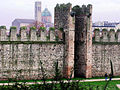
The walls of Citadel
- 4 Citadel - The walled circle surrounding Cittadella (1220 AD) has the shape of an irregular ellipse and with the inhabited area constitutes an organic complex of the highest historical interest, not only for the studies on castles but also for those of urban planning. The internal space that the walls delimit is ordered by two crossbars that connect the four doors with the center, dividing the town into districts, in turn divided into a checkerboard by the characteristic streets. The walled curtain communicates with the outside through four bridges at the gates (in turn built on the four cardinal points), facing the nearby cities of Padua, Vicenza, Bassano del Grappa is Treviso. The drawbridges, which were kept in service until the 16th century, were gradually replaced with masonry ones. The current ones date back to the first half of the last century.
Carrarese Castle of Este
- 5 Este - The main attraction of the town is the Carrarese Castle, built around 1339 on the ashes of the Estense one; at the top of the hill is the keep, from which the walls start, forming a polygon surrounded at regular intervals by towers and the restored castle of Soccorso. The Rocca di Ponte di Torre is what remains of the detached forts which, in addition to the castle and the turreted walls, had already defended Este from the times preceding the Carrarese period. Structurally, it is composed of a wall and a square tower, 24 meters high.
- 6 Monselice - The happy central position at the intersection of important roads and waterways favored a fairly early settlement. The birth of Monselice as a city center dates back to the V-VI century and is due to an initial fortification of the Rocca hill by the Byzantines, a fortification that is important in terms of defensive strategy. The existing structures were further strengthened after the invasion of the Franks, and consisted, around the year 1000, of a discontinuous inhabited fabric on the slopes of the Rocca and a defensive nucleus guarding the bridge over the ancient Vigenzone river, which passed to the foot of the hill.

Walls of Montagnana
- 7 Montagnana - The current walls, which constitute one of the most distinguished and best preserved examples of medieval military architecture in Europe, except for the complex of Castel San Zeno and the stretches of walls to the east and west which are more ancient, date back to the mid-fourteenth century, when the Carraresi, lords of Padua, they wanted to expand and strengthen what was an essential strong border place of the Paduan state against the Verona of the Scaligeri, which dominated the neighbor Legnago. The urban space intra moenia it was enlarged on that occasion, and the new enclosure was built with superimposed layers of bricks and stones. The fortified city is enclosed in an irregular quadrilateral measuring approximately 600 x 300 meters with an area of 24 hectares and a perimeter of approximately two kilometers. The walls, crowned by Guelph-type merlons, are 6.5 to 8 meters high, with a thickness of 96-100 centimeters. Between one blackbird and another, wooden fans served to repair the defenders. The perimeter towers, in total 24, spaced about 60 meters, are between 17 and 19 meters high. The external valley varies from 30 to 40 meters. The warehouses for the safekeeping of goods produced in the countryside were located inside the archways that support the patrol path. In the towers, with several floors and covered by a sloping roof hidden under the pitch equipped with a launching machine, there were other warehouses and quarters for the soldiers placed as garrison of the fortress in times of war emergency. An area devoid of buildings and used as a cultivated pomerium to face long sieges, was all around the walls from the inside.

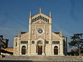
Sixteenth-century walls of Padua
- 8 Padua - The city from the medieval period onwards had three circles of walls that fortified the city over time. The first circle, built between 1195 and 1210, is that of the so-called "municipal" walls because it was erected during the period of the free Paduan municipality. It surrounded the most central part of the city, the so-called "insula" as it was entirely surrounded by canals (now partly disappeared). Three gates remain of this circle: two of them still passable today (Porta Molino, Porta Altinate, Porta della Cittadella Vecchia) while a third was incorporated in the fourteenth century in the Castelvecchio structures. In addition, there are numerous sections of the walls along the ancient route, often incorporated between modern buildings. During the fourteenth century, with the expansion of the urbanized areas, the so-called "Carraresi" walls were built at various times because they were largely built during the Da Carrara lordship. Very few remains of these walls remain visible in elevation, and are mostly incorporated into other Renaissance buildings and fortifications. These still medieval walls resisted, with appropriate adaptations, the siege that Padua suffered in 1509 by the troops of the Cambrai league. Following this siege, the Serenissima decided to equip the city with a new circle of walls suitable for resisting the introduction of artillery in warfare techniques. The works began in 1513 and went on until about the middle of the 16th century. This circle still exists almost entirely albeit in different states of conservation depending on the various traits. Its perimeter is about 11 kilometers, with 20 bastions and 6 gates (out of the original 8). These walls are usually referred to as "Venetian" or "Renaissance".
In the province of Treviso

Asolo, the fortress
- 9 Asolo - Administered in the late Middle Ages by the bishop of Treviso, Asolo consolidated its strategic importance with the construction of the imposing fortress (XII century). The fort, conquered in 1239 by Ezzelino da Romano, returned, on his death, to the municipality of Treviso who installed a captain there, strengthened the already present garrison and granted the city a certain autonomy. After the Scaligeri, Asolo passed to the Serenissima, who erected it as the seat of the Podesta Office. After the parenthesis of the Carraresi, Venetian rule was confirmed. In this period the walls were strengthened and completed and the loggia renovated.

The walls of Castelfranco Veneto
- 10 Castelfranco Veneto - The Castelfranco wall settlement was founded between 1195 and 1199 when the recently formed Municipality of Treviso felt the need to guard the border with its rivals Padua is Vicenza, in an area where the Muson River represented the only ephemeral natural demarcation. The chosen site was located in a strategic position: a pre-existing embankment on the eastern bank of the watercourse, close to the confluence of the Via Postumia and Aurelia and in a central position between the noble fortresses of Castello di Godego and Treville and the bishops of Salvatronda, Riese and Resana. The work was directed by Count Schenella di Collalto, who employed about five hundred master masons and a thousand "sappers" (unskilled workers). In a decade the construction could be considered complete: around the walls of the castle a moat was dug into which the waters of two tributaries of the Muson were diverted: the Avenue and the Musonello.
- 11 Conegliano Veneto - The area, located halfway between the mountain and the plain and a crossing point to reach Friuli, has always been a strategic site. A fortress controlled by the bishops of Belluno was built around the 10th century. Conegliano "was born" however in the twelfth century, when a group of noble families organized themselves by creating a municipal government around the fortress, with the consequent formation of a village. Conegliano Castle always remained the center of power, both civil and religious. With the bloody assault of 1153, Conegliano was immediately subjected to the municipality of Treviso which strengthened its defenses, rebuilding the castle, given the key position towards Friuli with the domains of the Patriarchate of Aquileia. The town followed the fate of the Marca and passed to the Ezzelini and the Scaligeri, who provided it with new fortifications. Even with the Republic of Venice, to which Treviso passed in 1337, and the brief parenthesis of the Carraresi (1384-1388) the work was continued and a wall was raised to enclose the village. The fortification and expansion works continued in the following centuries, despite the disastrous attack of the Hungarians in 1411. In the eighteenth century the castle, already in ruins for some time, was largely demolished to provide salvage material useful for new buildings, including which the Town Hall.

Portobuffolé, Porta Friuli
- 12 Portobuffolé - The ancient Septimum de Liquentia (referring to the seven miles that separated it from Oderzo) was a modest rural village built in the third century BC. Fundamental is a document of 997: it is a rental contract between the bishop of Ceneda Sicardo and the doge Pietro II Orseolo in which the castro et portu ... on the spot Septimo, proving the existence of a fortified place and a river port. Confirmation of its strategic importance, during the feudal period the castle passed under the control of numerous authorities, both noble and religious. Perhaps at the beginning it was of the Carraresi, then being of the Patriarch of Aquileia. In 1166 the center fell into the orbit of the municipality of Treviso, but in 1242 it returned under Ceneda. The fortress was then destroyed by the Treviso-born Gerardo de 'Castelli, only to be taken up and restored by the bishops. On 2 October 1307 Portobuffolé was assigned to Tolberto da Camino, husband of the famous Gaia. But the disputes did not cease: in 1336 Samaritana Malatesta, Tolberto's second wife, managed to regain control of the castle with the support of the Venetians.
- 13 San Zenone degli Ezzelini - After the fall of the Roman Empire, the area maintained its key role from a military point of view. In this period the hill of San Zenone was probably fortified, as part of a larger defensive system built by the Lombards. It was perhaps the presence of the castle that led to the development of a settlement with a church.

Gate of St. Thomas a Treviso
- 14 Treviso - The historic center is still partially enclosed by the walls built in 1509 in view of the war of the Republic of Venice against the League of Cambrai. In addition to the construction of imposing bastion walls and the deviation of part of the Botteniga river, the project of friar Giovanni Giocondo, to whom the Council of Ten had entrusted the fortification works, also involved the demolition of several buildings, including part of the ancient sanctuary of Santa Maria Maggiore. Numerous passages were added to the three monumental gates mentioned below in the second half of the twentieth century. Porta di San Tommaso, erected in 1518 by the podestà Paolo Nani on a project, perhaps, by Guglielmo Bergamasco. Porta Santi Quaranta, guaranteed access from the west, is dedicated to the Forty martyrs of Sebaste. In the Risorgimento period the door took on the name of Porta Cavour. Porta Altinia, the name of the gate, which faces east, is linked to the Roman city of Altino, from which it could be reached through the current provincial "Jesolana". It was built in 1514 next to a previous medieval gate of which the vaults still exist. Its appearance, with exposed brick and few stone decorations, is decidedly more sober than the other two doors. The upper part is shaped like a tower with large windows on the internal and external facades, while the side fronts still have the holes of the gunboats.
In the province of Venice

Tower of the Mestre castle
- 15 Mestre- Two distinct fortresses were built in Mestre, better known as Castelvecchio and Castelnuovo, built to defend the village and the port of Mestre and now disappeared. Built in the 11th century by the Bishops of Treviso, the castle stood where the two branches of the Marzenego river separated, west of the village of San Lorenzo. The function of the fortress was to control the area where the important port of Cavergnago stood, the river port that guaranteed trade between Treviso and Venice and between this and the entire mainland. The existence of the castle in this period is also testified by the papal bull Justis fratrum of 1152 with which Pope Eugene III recognized the ownership of the castle, the port and the village to the bishop Bonifacio. The castle was conquered by Ezzelino da Romano around 1245 who occupied it until 1250. In 1257, finally, the bishop Adalberto III Ricco was forced to cede the lordship to Ezzelino's brother, Alberico da Romano, mayor of Treviso. The municipality of Treviso then began to send a captain to govern the fortress and the village. In 1274 the old castle was almost completely destroyed by a raging fire. In 1317 Cangrande della Scala began to threaten Treviso, which, among other things, reinforced the castle of Mestre as a countermeasure. In 1318 the Scaligers tried several times to conquer the stronghold, which however resisted against all expectations. In 1323, however, the castle passed, together with Treviso, under the Veronese dominion. The Castelnuovo, that is, the primitive nucleus of the present city of Mestre, was characterized by the branching off of three large land routes: the Padovanao and the Castellana road towards Trento and the Tyrol. After the Venetian conquest of 1337, the town's importance increased compared to the old port of Cavergnago and the course of the Marzenego, they pushed to build a new and larger fortress. The surviving tower, photographed from what was the interior of the Castelnuovo, after being freed from the "Cel-Ana" building (demolished in 2009), an urban operation that created a "new" square in front of it. You can see the walled opening of the medieval gate. Also visible is the external access staircase (2003), for many reasons of discord. The new defensive complex was built further east of Castelvecchio (which was on the site of the Roman Castrum) and north of the village, where previous defensive towers already existed, tower-houses belonging to the noble families of the area. The new castle comprised a total of eleven towers, with three gates, consisting precisely of the pre-existing towers: the Porta Altino or dei Molini, to the east, the Porta Belfredo, to the west, and the Porta di Borgo or della Loggia, to the south. These gates were also called toll towers, since here the duties due on trade were collected. In the center stood the Keep. Opposite was the Palazzo del Capitano, where the Venetian rector resided, with the title of Podestà and Captain. The main towers were placed at the northern end; the whole was surrounded by a moat, fed with the waters of the Marzenego. In 1509 the Venetian forces retreating after the defeat in the battle of Agnadello, barricaded themselves in the castle of Mestre, which became the extreme bulwark on the mainland. In 1513 the castle had to face the enemy assault again, this time by the French, who managed to set it on fire, but were nevertheless rejected. In the eighteenth century the walls of the castle were demolished: of them only the Clock Tower (the ancient Porta di Borgo) and the twin Torre Belfredo remained. The latter was then in turn demolished in the nineteenth century. The few remains of Castelnuovo currently visible are (from the Civic Tower, "clockwise" in the plan of the castle): fragment of walls inside the courtyard of the "Cassa di Risparmio"; the gardens of Via Torre Belfredo and also a "torricino"; the marks on the pavement of the demolished Torre Belfredo in the homonymous street; the "corner tower" of via Spalti; the drawing (in the road pavement) of the bridge overlooking the "Torre Altinate" (the third gate of the Castle of Mestre, the one on the road to Altino, today "via Caneve") and the foundations of an intermediate tower rediscovered in the early 2000s and located "right on the corner" in today's piazzale Parco Ponci.
.jpg/120px-Rocca_dei_Tempesta_(Noale).jpg)
Castle of Noale
- 16 Noale - The fortress is presumed to date back to the 12th century and was the residence of the Tempesta, Lords of Noale. It was used for military purposes until the fifteenth century and then became the seat of the podestà until its final abandonment in 1763. From that same year many parts of the now dilapidated structure were deliberately demolished to obtain building materials "for the benefit of the community". The castle is flanked by the fortress, that is the area still surrounded by medieval moats which, with the shape of an irregular quadrilateral, straddles the direction Camposampiero-Mestre, enclosing the historic center of Noale. Inside the perimeter (but a real wall has never existed), the archpriest church and ancient houses decorated with frescoes rise as well as the large Piazza Castello, formerly Piazza Calvi. Two large entrance gates with dovetail battlements are part of the complex, flanked by the towers known as Torre dell'Orologio and Torre delle Campane.
In the province of Verona

Bardolino, vestige of the medieval fortifications.
- 17 Bardolino - Between the 9th and 10th centuries, to counter the numerous raids of the Hungarians, the main settlements on the shores of the lake were equipped with walls and castles, Bardolino was no exception. Little is known of the first fortification that was erected here, of which the first documents date back to 1100, but it is believed that its construction was granted to the Bardolinesi by the Emperor Berengario of Friuli; a similar permit was granted to all the communities of the lake. Later the castle was enlarged until it formed, with the Della Scala family, a single fortress for the whole town. The thick walls, surrounded by a large moat, closed the center of the village which could be accessed by only two gates: one placed to the north-east towards Garda called "San Giovanni" or "Superiore", one to the south-east called "Verona" or "lower". In 1193 Bardolino followed the fate of all the villas dependent on the Rocca di Garda, which were ceded with it by the Emperor Henry VI to the municipality of Verona.
- 18 Castelnuovo del Garda - From the discovery of some archaeological finds it can be deduced that the territory of the municipality was inhabited since prehistoric times. In ancient times the site was known as Beneventum; later it took the name of Quadrivium, due to its geographical position (the country is in fact located between the four cities of Verona, Mantua, Brescia and Trento). In the XII century Quadrivium was razed to the ground by Barbarossa: the population decided to build a new fortified settlement, Castrum novum, transformed over time into Castelnuovo. Passed in its history under different domains, (from the Lordship of the Scaligeri to that of the Visconti, from the Republic of Venice to the Austrian Empire) from 1867 the Municipality was called Castelnuovo di Verona.

Scaliger Castle a Cologna Veneta
- 19 Cologna Veneta - The ancient brick construction of the quadrangular civic tower is located in the center of the urban complex. Originally it was one of the twelve towers with two wooden floors of the walls that surrounded Cologne. Built in 1555, it was completed in two successive phases: to try to go back to the time of construction of the first part, it is possible to see a municipal coat of arms on the part facing Corso Guà, in its original and primitive composition. Later a sacred wooden effigy of the Madonna was placed on the facade overlooking Piazza Mazzini. The current clock has been in operation since 1914, while the original bell transported by the Serenissima was replaced in 1590 following damage from a bell, called San Simon, which bears a date: 1714.

Walls of Lazise
- 20 Lazise - The lakeside village of Lazise is equipped with a large part of the walls, of which only the northernmost part of the eastern curtain and the part of the western curtain that, starting from the castle, continued along the lake to the ancient port, has been lost, ending in the disappeared Cadenon tower, eliminated in 1939 to make way for the war memorial, but whose figure has remained in the memory of the Lacisiense community so much so that it continues to exist in the popular festival known as the Palio della Cuccagna del Cadenon, which takes place every year right where the medieval tower stood. The southern and northern curtain of the city walls are instead entirely preserved and interspersed, together with the remaining portion of the eastern curtain, by thirteen shielded towers and three city gates: Porta Nuova (or Cansignorio) to the north, built between 1375 and 1376 but walled up in 1701 to protect the village from some militias who were plundering the surrounding area, then reopened in 1955; Porta Superiore (or San Zeno) to the east, probably coeval with the early medieval structure, the only one intended for the population and transits, in whose external niche a Madonna and Child was originally painted, then replaced by the Imperial Eagle and finally by the image of San Marco, protector of the Republic of Venice; Porta Lion for access from the south, so called because it bore the coat of arms of the Serenissima or perhaps because it was used by the Venetian militias, once equipped with a ravelin in its defense. The doors were all equipped with a shutter and a drawbridge over the moat, this completely disappeared for long stretches.
_04.JPG/120px-Torrione_(Legnago)_04.JPG)
Tower of Legnago
- 21 Legnago - In Piazza della Libertà stands the Torrione, the only remaining example of the walls that surrounded the town. It is also considered the symbol of the city of Legnago precisely because it traces the indigenous architectural and military history. In ancient times it was used as a prison. The city walls (and therefore also the Torrione) were built starting from 1525 during the rule of the Serenissima, following the disastrous war of the League of Cambrai. The construction of the bastion walls only ended in 1559 and, over the years, saw the succession of illustrious architects such as Bartolomeo d'Alviano, Fra 'Giocondo, Michele Leoni and Michele Sanmicheli. The Venetian work was later modernized by the French first and then by the Austrians (remember that Legnago was part of the so-called Quadrilatero). The walls will lose their defensive role after the annexation to the Kingdom of Italy and will be demolished in 1887 as regards the right side of the Adige and during the 1920s on the left side of the river to give way to the expansion of the towns of Legnago and Porto. The keep has been restored several times, undergoing, over the years, heavy changes compared to its original architecture.
- 22 Malcesine - The city is well known for its imposing castle, probably built by the Lombards around the first half of the first millennium AD. The castle was destroyed by the Franks in 590 and rebuilt by them in 806. From 1277 to 1387, the castle was the residence of the Scaligeri of Verona. In May 1513 the leader Scipione Ugoni in the service of the Republic of Venice received the task of the Salodian administrator Daniele Dandolo of attacking Malcesine, loyal to the German imperials. At the head of 300 infantrymen, joined by the inhabitants of Gargnano, he attacked Malcesine via the lake and stormed the castle, killing 18 Terazzani and losing only 3 men; in the action he captured the German castellan and a rich Veronese citizen, who were taken prisoners to Salò together with a considerable booty. The keep stands for approx. 70 m on the lake and the fortification was also made famous by the drawings and descriptions provided by the German writer Goethe in his "Journey to Italy" (1813 - 1817).
- 23 Pastrengo - Four forts were built in Pastrengo between 1859 and 1861 at the request of General Radetzky. All the forts possessed the necessary services for a long use, and remained active until 1901: Forte Piovezzano (Degenfeld), Forte Monte Folaga (Benedeck), Forte Poggio Croce (Leopold), Forte Poggio Pol (Nugent).

Walls of Peschiera del Garda
- 24 Peschiera del Garda — Aryl, the name of the town during the Roman dominion, it must surely have already been fortified, as the foundations of two Roman towers near the bridge over the Mincio seem to demonstrate; on the other hand, Arilica was the base of the Roman lake military fleet, and such a strategic center had to be forcibly protected from possible external incursions. At the beginning of the thirteenth century it was fortified again and then strengthened during the following century by the Scaligeri and especially by Mastino II della Scala, who was responsible for the construction of the fortress and the completion of the walls: the village was thus protected on five sides by turreted walls and the Rocca located in the southern corner, as well as by the river Mincio that surrounded the town, as today. In the fifteenth century the stronghold of Peschiera passed under the control of the Republic of Venice, which decided to renovate the fortifications according to the criteria adopted at that time: the wall was then embanked and bastionized on a project drawn up by Guidobaldo della Rovere, whose entrusted to Michele Sanmicheli. This new fortified wall in the modern style followed the trend of the medieval one, therefore with five sides but with five corners protected by ramparts. Two doors were also opened along the walls, Porta Verona and Porta Brescia. Around the middle of the sixteenth century the Rocca Scaligera was modified and embanked to transform it into a knight, suitable for the use of modern artillery. At the beginning of the seventeenth century important restorations were carried out and the addition of ravelins in front of the access doors to the village. In 1797 the fortress came under the dominion of the Austrian Empire: Austria made considerable investments to strengthen the defenses in a short time and add important external military works. The French perfected the works towards the east, and therefore towards the Austrian enemy, creating the forts of Mandella Vecchia and Salvi Vecchia: the city remained under French control only for a short period, then returning under Austrian rule when the French Empire collapsed. . The Austrians built two more military fortifications near the previous ones, and for this reason they called Mandella Nuova and Salvi Nuova; dopo questi lavori Peschiera passò a costituire un robusto caposaldo del Quadrilatero, insieme a Legnago, Mantova is Verona. Altri importanti lavori vennero ideati a seguito della prima guerra di indipendenza, che aveva visto la fortezza assediata a catturata dai piemontesi: vennero realizzati i forti Cappuccini, Papa, Laghetto, Saladini, Baccotto, Ardietti, Cavalcaselle, Polverina e Fucilazzo. Passato infine in mano italiana a seguito della terza guerra d'indipendenza, la piazzaforte perse di importanza strategica.

Forte di Rivoli Veronese
- 25 Rivoli Veronese — Nelle immediate vicinanze di Rivoli, tra il 1850 e il 1851 fu costruito un forte in cima alla collina chiamata Monte Castello. Assieme ai forti di Ceraino e Monte proteggeva le strade che da Affi passando a Rivoli collegavano il Lake Garda all'Adige. Denominato "Wohlgemuth" in onore di un generale austriaco distintosi nella campagna del 1848, il corpo principale del forte era inizialmente costituito da una doppia casamatta semicilindrica sovrapposta. Era dotato di 17 cannoni. Dopo la conquista italiana, la costruzione fu completata fortificando la parte esposta a nord, fino a quel momento del tutto indifesa poiché originariamente il forte era stato concepito per difendere i confini austriaci e quindi era rivolto verso sud. Al successivo adattamento ai mutati confini italiani si deve pertanto l'attuale forma cilindrica del forte. Il forte ed il complesso circostante di fortificazioni ospitano attualmente un museo della prima guerra mondiale.

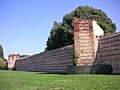
Mura di Soave
- 26 Soave — Le mura vennero costruite nel 1369 per volontà di Cansignorio della Scala e raccolgono al loro interno il nucleo storico di Soave. Anticamente solo tre porte si aprivano nella cinta: Porta Aquila (ora Porta Bassano) a nord, Porta Vicentina ad est e Porta Verona a sud (recentemente restaurata). Per due lati (ovest e sud) le mura sono accompagnate dal fossato naturale formato dal Tramigna.

Castello scaligero di Torri del Benaco
- 27 Torri del Benaco — Torri del Benaco - posta a mezza via fra Peschiera del Garda is Riva del Garda - potrebbe essere stato un castrum romano e, come tale, venne difeso e fortificato dalle legioni romane insediatesi sulla sponda orientale del lago di Garda (Benaco) (15 a.C.). A testimoniarlo è la torre posta a occidente, sicuramente antecedente e nettamente diversa, sul piano architettonico, rispetto alle altre due. La struttura complessiva, comunque, potrebbe risalire al X secolo, ovvero al tempo di Berengario del Friuli re d'Italia, il quale avrebbe fatto restaurare un preesistente maniero per predisporre una difesa efficace a protezione del monte Baldo e soprattutto in funzione degli attacchi degli Ungari che imperversavano nella pianura padana. Contiguous to the Berengario castle he built curtain walls whose remains are still visible between the historic center of Torri and the Gardesana. Berengario is also credited with building the tower that bears his name located in the church square. In the 14th century, and precisely in 1383, Antonio della Scala, the last lord of the Della Scala family, entrusted Bonaventura Prendilacqua with the renovation of the castle, as a plaque on the west side of the western tower recalls. In later times, a few days of assaults on the Visconti lords of Milan were enough to conquer the fortress. A inizio del XV secolo toccò ai veneziani della Serenissima Repubblica veneziana (1405) subentrare nel possesso del castello, peraltro ormai avviato al proprio declino culminato trecento anni dopo nell'abbattimento della cinta muraria esterna.

Castello scaligero di Valeggio sul Mincio
- 28 Valeggio sul Mincio — La scelta di questo luogo per la realizzazione di una fortificazione non era certo casuale ma era fatta per un certo motivo. Da secoli infatti esisteva uno dei punti più sicuri per l'attraversamento del fiume Mincio di notevole importanza strategica, proprio nella sottostante valle. In quel periodo il fiume Mincio segnava il confine tra il Sacro Romano Impero della nazione germanica e il Marchesato di Tuscia, formato dai vasti possedimenti dei potenti Canossa. Il violento terremoto del 3 gennaio 1117 scosse l'Italia settentrionale, abbattendo gran parte degli edifici in muratura, primi fra tutti le torri ed i campanili. Fu così che crollò la prima vera fortificazione valeggiana, lasciando superstite la sola Torre Tonda. Il punto di svolta si ebbe nel 1262, quando venne eletto Capitano del Popolo Mastino I della Scala e nel giro di pochi anni la famiglia degli Scaligeri assumerà il controllo totale del potere in Verona e i lavori di ricostruzione e di ampliamento della zona fortificata di Valeggio. Oltre alla realizzazione della Rocca e del Castello precedentemente citati, fu edificato l'avamposto sulle rive del Mincio. Sulla collina, una muraglia (la “Bastita”) garantiva il collegamento fra la cinta turrita e il Castello. I lavori di un'altra "Bastita" iniziarono nel 1345, ad opera di Mastino II Della Scala. Questa seconda opera fu ben più impegnativa della precedente ed era parte di una poderosa linea difensiva costituita da fossati e mura merlate intervallate da torresini, scendeva dal Castello, circondava il piccolo villaggio di Valeggio, raggiungeva dopo quattro chilometri il fortilizio della Gherla, proseguiva lungo il fiume Tione toccando il castello di Villafranca di Verona per terminare, tre chilometri oltre, nelle campagne paludose che circondavano Nogarole. Quest'opera difensiva, il cosiddetto "Serraglio scaligero", era lungo circa 16 km. Nel 1348 la famosa "Peste nera" colpì anche Valeggio che falciò i due terzi delle popolazioni colpite e poco dopo l'ultimazione dei lavori, gli Scaligeri vennero sconfitti dai Visconti di Milano, i quali conquistarono il Serraglio e le roccaforti valeggiane, nel 1387. Nel 1393 il conte di Virtù, Gian Galeazzo Visconti, Signore di Milano, realizzò un complesso fortificato unico in Europa attraverso il raccordo del suo famoso Ponte-diga visconteo con la Rocca di Valeggio tramite due cortine merlate. Il lento decadimento delle strutture tardo medievali iniziò durante la dominazione veneziana: le torri, superate dalle più moderne costruzioni strategico-militari ed impotenti di fronte alle nuove micidiali artiglieri, cominciarono crollare. Intorno alla metà del XVI secolo, la Serenissima cedette ai privati sia il Castello che il Ponte-fortificato. Con il passare dei secoli, a causa delle guerre e dell'incuria degli uomini gli antichi monumenti sono andati incontro ad un progressivo degrado.

Le mura scaligere di Verona
- 29 Verona — Il sistema difensivo urbano a destra d'Adige riferibile ai secoli XII e XIII è formato da due recinti murari, che seguono il corso dell'Adigetto con tracciati irregolari e pressoché paralleli. Nel corso del tempo si sono sovrapposti restauri e ricostruzioni su entrambe le muraglie, tanto che ora si possono solo formulare delle ipotesi sui tempi e sui modi della loro costruzione. L'esistenza di una cinta urbana lungo l'Adigetto è documentata già nella prima metà del XII secolo (1157); una seconda fase può essere delimitata tra il 1239 (anno in cui un'inondazione causò il crollo della cinta in due tratti) e il 1259; in questo periodo Ezzelino III da Romano aveva l'interesse di tenere a Verona una solida base per la sua armata. L'assetto allora raggiunto è da considerare come una soluzione compiuta: il sistema cinta-antemurale-fosso si configura come un tipo fortificatorio fondato sul concetto della difesa graduale. Nel 1325, la costruzione della cinta di Cangrande I della Scala a destra d'Adige ampliava considerevolmente le dimensioni della città e spostava la difesa principale ben oltre la vecchia cinta comunale. In epoca viscontea (1387-1402) il sistema già predisposto dalle fortificazioni scaligere trovava un'ulteriore consolidamento con la formazione della Cittadella, compreso tra la cinta comunale-ezzeliniana, la cinta di Cangrande I (lungo la riva dell'Adige, a est, e lungo il fronte urbano meridionale, e delimitato a ovest dalla nuova muraglia con fosso antistante (lungo l'attuale corso Porta Nuova). Questo ampio spazio, destinato all'accampamento delle milizie e alle attrezzature logistiche, era in diretta comunicazione con Castel Vecchio attraverso la strada coperta esistente tra la cinta comunale e l'antemurale, lungo la quale potevano transitare milizie e artiglierie. Le cortine murarie comunali conservate tra la Gran Guardia e l'Adige (tratto della Cittadella) sono state più volte rimaneggiate, adattate alle rinnovate destinazioni degli edifici tra di esse costruiti, trapassate e interrotte da un nuovo fornice (verso stradone Maffei) e da una breccia (lungadige Capuleti). Nulla rimane delle porte medievali (Porta della Paglia e Porta Rofiolana), in seguito all'allargamento dei fornici.

Mura del castello di Villafranca di Verona
- 30 Villafranca di Verona — La città faceva parte del "Serraglio veronese" o "Serraglio scaligero", opera di fortificazione lunga 13 km edificata dagli Scaligeri tra il XIII e il XIV secolo per proteggere il territorio veronese dalle incursioni milanesi e mantovane. Di fronte al castello di Villafranca, al di là del Tione, era stato innalzato una specie di grande antemurale, il Porton, che dava accesso alla porta sud e quindi alla corte d'armi del castello. L'opera, iniziata da Mastino II nel 1345 e completata da Cangrande II nel 1355, venne nel 1359 inglobata in un recinto quadrato di 140 metri di lato, con alte cortine e 10 torri, che racchiudeva il castello e consentiva lo stazionamento, oltre a parte del presidio del Serraglio, di 200-250 cavalieri. In tal modo Villafranca divenne il centro di comando del Serraglio. Dopo la caduta della signoria scaligera, l'opera venne rafforzata da Gian Galeazzo Visconti con la costruzione a cavallo del Mincio del Ponte-diga, raccordato con tratti di mura al castello di Valeggio sul Mincio. Di tutto il "Serraglio" restano oggi, oltre a Borghetto, il castello di Valeggio sul Mincio, il vallo ancora visibile lungo la strada SP24 già a partire da Valeggio sul Mincio anche se adibito ad attività agricole o parzialmente interrato, i ruderi del castelletto della Gherla (fortilizio a pianta poligonale con una porta verso Custoza oggi in stato di abbandono, la cui importante caratteristica era la comunicazione visiva tra il castello di Valeggio e quello villafranchese, il castello di Villafranca (e qualche rudere lungo il fiume Tione).
In provincia di Vicenza

Castello di Arzignano
- 31 Arzignano — Le opere murarie più antiche sono i resti di una antichissima fortezza sulla cima del colle di San Matteo alle spalle del borgo di castello. L'attuale rocca del Castello è di epoca scaligera e probabilmente sorta sui resti di una precedente fortificazione romana. Alla fine di gennaio del 1413 il castello venne messo sotto assedio dalle truppe degli Ungheri di Filippo Buondelmonti degli Scolari, detto Pippo Spano, durante una campagna di Sigismondo, re d'Ungheria contro la Repubblica di Venezia. Dopo alcuni giorni, gli arzignanesi, forse mancando i viveri, fecero voto a Sant'Agata, e miracolosamente il 5 febbraio (giorno della morte della santa avvenuta nel 251) l'assedio venne tolto, grazie anche allo stratagemma di gettare dalle mura del castello viveri e granaglie, per ingannare gli assedianti sulla disponibilità di provviste.

Castello di Bassano del Grappa
- 32 Bassano del Grappa — La costruzione del castello è da inquadrare nelle prime fortificazioni difensive sorte attorno alla Chiesa di Santa Maria, come testimonia un documento risalente all'anno 998; nella seconda metà del XII secolo il vescovo di Vicenza, cui il castello apparteneva, lo donò a Ecelo I, capostipite di quella che fu la potente famiglia degli Ezzelini. Le strutture più antiche ancora presenti risalgono ai secoli XII e XIII, periodo in cui venne costruito il muro di cinta pentagonale a nord e la torre dell'Ortazzo. Il castello fu operativo durante le dominazioni degli Scaligeri (1311-87), dei Visconti (1387-1404) e infine della Repubblica di Venezia dopo la dedizione del 1404. Nel 1411 - durante la guerra tra la Repubblica di Venezia e il Regno d'Ungheria - le sue fortificazioni resistettero agli attacchi delle prime bombarde messe in campo dalle truppe dell'imperatore Sigismondo di Lussemburgo che devastavano il territorio; caddero invece sotto l'urto degli eserciti di Massimiliano I d'Asburgo, durante la guerra della Lega di Cambrai nel 1508.
Il duomo di Lonigo
- 33 Lonigo — Alla fine del IX secolo, a causa delle prime scorrerie degli Ungari, l'abitato tra Santa Marina e San Tomà fu distrutto; parte della popolazione si rifugiò a Bagnolo e parte si insediò nel centro di Lonigo, dove fu costruita una fortificazione nei pressi di dove oggi sorgono il duomo e Villa Mugna. Forse, però, era qualcosa di più di una semplice barriera a protezione della chiesa e degli inermi, ma un vero e proprio castello costruito per i Malacappella. Quest'ipotesi è sostenuta dal fatto che l'antica pieve di san Cristoforo, interna al castello, esercitava la sua giurisdizione solo nello stretto ambito cittadino e nel secolo XIV non aveva ancora cappelle dipendenti, il che dimostra che era di origine gentilizia. Il castello dei Malacappella venne inizialmente detto "Calmano", ma più tardi, in epoca veneziana, venne semplicemente chiamato "Castellazzo" (o "Castellaccio"): come risulta dalle antiche cronache, era certamente di dimensioni cospicue, disponeva di ampio fossato circostante, di ponte levatoio e di numerose canipae sotterranee in grado di assicurare la sussistenza per lunghi periodi a più di 1500 persone. Anche se molto probabilmente sopraelevate e rinforzate in epoca scaligera, del castello dovevano far parte anche le due torri che tuttora esistono davanti e dietro al Duomo.

Mura di Marostica
- 34 Marostica — La costruzione delle mura ebbe inizio il 1º marzo 1372 da parte di Cansignorio della Scala. Sono quattro le porte che permettono di accedere al centro storico caratterizzato dalla "Piazza degli Scacchi": la Porta Vicentina a sud, quella Breganzina ad ovest, quella Bassanese ad est e la Porta del Castello Superiore a nord. Lungo le mura ci sono dei camminamenti, gli stessi che in epoca antica permettevano un servizio di guardia. Tra il 1934 e 1935, nella parte sud della mura, fu praticata una nuova apertura al fine di agevolare l'accesso alla ex stazione ferroviaria.
Mura scaligere di Vicenza
- 35 Vicenza — La necessità di creare dei solidi baluardi alle città si presentò nel IX secolo, in seguito alle devastanti incursioni degli Ungari nella pianura veneta. Così anche a Vicenza si ebbe il fenomeno dell'incastellamento e, probabilmente nel X secolo, si cominciò ad erigere delle solide mura, che racchiusero dapprima il nucleo più antico e nel XIII secolo inglobarono anche una parte dell'ormai popolato Borgo Berga. Questa prima cortina di mura formava un anello quasi del tutto circolare.
Safety
Around
Escursioni

Morainic hills of Lake Garda
- Lake Garda — È uno dei grandi laghi lombardi; la sponda orientale è veneta, la punta a nord è trentina. Meta di turismo climatico fin dall'Ottocento, ogni paese rivierasco vive e si sviluppa con il turismo. Mete principali sono Sirmione, Desenzano del Garda, Salò, Riva del Garda, Garda, Peschiera del Garda.
Itineraries
- Morainic hills of Lake Garda - On the first corrugations of the Po plain that becomes a hill, where the great lake basin of the Lake Garda, the route touches towns and cities that were the domain of Gonzaga, Venice, Scaligero, and then became the scene of the bloody battles of the Risorgimento that were the prelude to the unification of Italy. To the tourist, historical and naturalistic importance the area combines an oenological interest as an area of production of wines from the hills, tokai, merlot e chiaretto.
- Monti Lessini — Un itinerario che tocca una zona del Parco naturale regionale della Lessinia e che si sviluppa nella parte settentrionale della provincia di Verona in un corpo territoriale che va dai 1200 metri alle cime; comprende alcune isole ad altezza più bassa che comprendono luoghi di bellezza naturale. Nel parco sono compresi tutti i monti veronesi ad esclusione del Monte Baldo.