| Vermilion | ||
 | ||
| State | Italy | |
|---|---|---|
| Region | Trentino Alto Adige | |
| Territory | Trentino | |
| Altitude | 1.261 m a.s.l. | |
| Surface | 95.64 km² | |
| Inhabitants | 1.882 (2015) | |
| Name inhabitants | Vermillians | |
| Prefix tel | 39 0463 | |
| POSTAL CODE | 38029 | |
| Time zone | UTC 1 | |
| Patron | Saint Stephen | |
Position
| ||
| Institutional website | ||

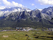
Vermilion is a center of the Trentino Alto Adige.
To know
At the beginning Vermiglio was called Armilla, then its name evolved up to Vermiglio, due to the color of the blood of the First World War, fought at Passo Tonale, where the Vermigliani had been evacuated to Mitterndorf.
Geographical notes
It is located in the district of Val di Sole. To the west of the town there is a valley about 3 km long, wide and green due to the cultivated meadows, crossed by the Vermigliana stream, which flows into the Noce stream downstream of Vermiglio, to continue its run up to the Adige river.
How to orient yourself
The main center is made up of three hamlets: Pizzano, the largest, Fraviano and Cortina, which are hardly distinguishable today and practically form a single inhabited center.
Neighborhoods
The municipal territory includes the hamlets of Cortina, Fraviano (municipal seat), Pizzano and Tonale.
How to get
By plane
- 1 Bolzano-Dolomites Airport (IATA: BZO) (6 km from the center of Bolzano), ☎ 39 0471 255 255, fax: 39 0471 255 202.
 open to the public: 05: 30–23: 00; ticket office opening: 06: 00-19: 00; check-in for flights from Bolzano is only possible from 1 hour to a maximum of 20 minutes before departure. Small regional airport with scheduled flights to and from Lugano is Rome with Etihad Regional (by Darwin Air). At certain times of the year, the Lauda Air company connects the city with Vienna once a week. On the other hand, charter flights are more numerous.
 - 2 Verona Airport (Catullus), Boxes of Sommacampagna, ☎ 39 045 8095666, @[email protected].
- 3 Brescia Airport (D'Annunzio), Via Aeroporto 34, Montichiari (Connections with Brescia airport are guaranteed by public transport via the bus. The stop a Brescia city is located at the bus station (number 23), while that of the airport is at the front of the terminal. There are also connections to the city of Verona via bus / shuttle line 1), ☎ 39 045 8095666, @[email protected]. Charter only
By car
 It is located on state road 42 del Tonale and Mendola.
By bus
 Public bus transport services in Trentino are managed by Trentino Trasporti [1].
How to get around
What see


- Passo del Tonale. The Tonale pass (pas del Tonàl in solandro, pas del Tunàl in camuno), located at 1,883 m asl, is an alpine pass in the southern Rhaetian Alps that divides the Ortler Alps to the north and the Adamello and Presanella Alps. South. It connects the Val di Sole (municipality of Vermiglio) with the Alta Val Camonica (municipality of Wooden bridge).
- Located on the administrative border between Lombardy is Trentino, has developed urbanistically in recent decades outside the rules, with excessive building speculation (especially on the Trentino side) which has led to the strong contrast between the decidedly oversized architecture and the surrounding environmental context, definitively destroying the serene mountain landscape that still characterized it in the sixties of the twentieth century.
- The Tonale can be reached via the state road 42 of the Tonale and the Mendola, which connects Treviglio in from Bergamo with Bolzano through the two passes of the same name, or by plane through the same altiport, located at the beginning of the town on the province side of Trento.
- A tourist center both in summer and in winter, the Tonale pass is a base for numerous mountaineering and hiking itineraries that allow you to make contact with the nature of the Rhaetian Alps and the historical reality of the White War which here has left numerous signs still alive in the landscape. The mountains surrounding the Tonale pass were in fact the scene of fighting during the First World War: a Monumental shrine, a work by Timo Bortolotti created in the 1930s, today houses the remains of over 800 fallen Italians and Austro-Hungarians. In the area it is possible to visit the White War Museum in Adamello in Temù, in addition to the interesting collections of relics from Vermiglio and Peio. In 2011 a Paradise pass, at 2600 m a.s.l., a multimedia path has been inaugurated inside an original gallery of the conflict: Sounds and voices of the White War.
- Ski equipment
- Largest among the winter sports resorts of the Trentino and of Lombardy, has a ski area with over 100 km of slopes which since winter 2006, thanks to a cable car, has been permanently integrated with the stations of Ponte di Legno and Temù. Thanks to the slopes of the Presena al Tonale glacier it is also possible to ski from October to July.
- Alpine pass with not high cycling difficulties, the Giro d'Italia has passed through it several times. During the summer, the Tonale Airfield is also active.
On the road that leads from the town to the Tonale pass, there are five Austrian fortifications from the First World War:

- Forte Saccarana (Fort Zaccarana; Forte Tonale). It is an Austrian fort (in German Werk Tonale) built to defend the borders of the Austro-Hungarian Empire. It belongs to the "Tonal Barrage" of the "Subrayon II" of the great Austrian fortification system on the Italian border.
- It was built between 1908 and 1912, at 2,116 meters above sea level. This fortification dominated the Passo del Tonale and represented the highest fort of the Austrian forts of the time. It was connected by fort Mero to fort Presanella.
- It was a large building divided into three blocks, until it fell into ruins over the years. This fort has also recently undergone restoration work.
- Its armament consisted of 4 10 cm Mod. 09 howitzers, placed on revolving armored domes; 2 armored casemates that housed: 8 cm Mod. 05 guns, 17 8 mm M 07/12 Schwarzlose machine guns
- Fort Mero. It was built between 1911 and 1913 and represented the link between Fort Saccarana and Fort Presanella.
- It was a medium-sized fortification, made of compressed concrete and iron beams.
- Specifically, the fort had to block the road that goes up to the Tonale pass. It was designed by Lieutenant of Engineers Hugo Hartmann, at a cost of 500,000 crowns.
- The fortified structure had a short life as the Italian artillery centered it and demolished it in 1916. What remained was arranged to house a field hospital for the Tonale line. Its armament consisted of 7 8 mm M 07/12 Schwarzlose machine guns.
- Restoration works are also underway for this fort.
- Fort Velon (Forte Vermiglio). It dates back to 1891 and was built in local granite blocks. It constituted an accessory work to the overlying Fort Strino to which it was connected by a fortified staircase. It extended on one floor and was armed with 4 guns. Its purpose was to block the entrance to the nearby Val di Stavel and to control the Vermigliana valley floor.
- Today the fort is reduced to ruins and is in a bad state.

- Fort Strino. It was the first of the forts built in the upper Vermiglio valley and currently hosts an exhibition dedicated to the "Great War" and an exhibition of contemporary art.
- The fortress was built between 1860 and 1866 at an altitude of 1,538 m a.s.l. for the purpose of control and defense of the last stretch of the road to the pass. The structure has a semicircle-shaped plan, articulated on two levels. In the first level it had three stations, while on the second level four, positioned towards the road of the Tonale pass and the Vermiglio valley. In addition to the fighting chambers, the fort had a series of loopholes for close defense. The lower part of the fort also served as a road cut (today partially demolished due to the passage of the road).
- In 1891 a second fortified structure was built under the fort, the Velon fort, a modestly sized structure, with which it was connected through a steep staircase about 140 m long covered with vault, the so-called "caponiera". In addition, the following fortifications were added to the barrage: Fort Presanella to the south, and Fort Mero and Fort Saccarana to the north (also known as Fort Tonale).
- The fort completely self-sufficient: it was complete with drinking water, bread oven, infirmary, electricity generator, optical signal and telephone to connect with the other forts and with the front-line stations or with the central station of Malè. There was also a dovecote to guard the bodies of the dead.
- The command of the fortress was subject to the IX battalion of Innsbruck, while the garrison was made up of "hunters" from Rovereto and Pergine Valsugana. It had an armament of 4 150 mm guns (in gunboat), 2 80 mm guns (in casemate), 4 8 mm machine guns.
- Only after the end of the conflict was the partial destruction of the fortress, therefore not caused by war events, but rather to a phase of depredation of the iron and granite cut stone that covered it.
- The municipality of Vermiglio, with the autonomous province of Trento, given the deterioration, it decided and promoted its restoration by consolidating the structures, removing the rubble and eliminating the dense vegetation that had covered it.
- After a restoration of the work, in 1997 the Forte Strino di Vermiglio Committee was set up, to which the municipal administration delegated the creation and enhancement of an exhibition space at Forte Strino.
- In 2008 the committee was replaced by a similar association, which guarantees guided tours in the summer months.

- Fort Presanella (Forte Pozzi Alti). It is accessible after traveling about 8 kilometers south-east from the hamlet of Velon di Vermiglio, on the eastern part of the valley. It was built between November 1906 and 1912 with the aim of blocking the road of the Val di Sole, together with the neighbor Forte Saccarana. It was therefore built on the right side of the valley, at an altitude of 1,880 meters. Above the fort a wall protected from possible avalanches. This fort is also the subject of some restorations in recent years.
- As main armament it was equipped with three 100 mm howitzers, housed in M09 (TH2-4) revolving armored dome with a wheelbase of 16.8 meters. In addition, the fort was armed with two M05 80 mm guns, housed in armored casemates (KP5 and KP6), as well as 15 M07 / 12 Schwarzlose 8 mm machine guns.
After many kilometers on foot you will arrive at
- Denza Refuge. The Stavèl Francesco Denza refuge is an important SAT alpine refuge located at the foot of the moraine of the Presena glacier of the Presanella group (Southern Rhaetian Alps), in the territory of Vermiglio (TN), at an altitude of 2,298 m a.s.l.
- Built in 1898 and inaugurated on 21 August 1899, it stands on a natural terrace at the foot of a very suggestive alpine lake in whose waters the Presanella is reflected. It is the starting point of numerous crossings, as well as of the routes that lead to the Presanella peak and to the Vermiglio peak.
- The refuge was renovated in the years 2000/2001 and has 56 beds and a hydroelectric power station that supplies electricity to the whole complex, which includes a winter hut and a mountain church.
- The name of the refuge is dedicated to Father Francesco Denza, a Barnabite friar, who was an astronomer and distinguished meteorologist, as well as director of the Vatican Observatory from 1890 to 1894.
- Accesses
- - from Forte Pozzi Alti, reachable by road from Stavel, trail 206 - 1.30 hours
- - from the Velon hut m. 1354 in val di Vermglio (accessible by road from the state road upstream of Vermiglio), trail sign 233 that cuts the hairpin bends of an old military road to the ruins of the Austrian fort of Presanella (Fort Pozzi Alti) m. 1884, then the path that crosses the signpost 206 coming from Val Stavel - 2.45 am
- - from Stavel (road of 5 km from Vermiglio), then path 206 which from the Masi di Stavel m. 1273 passes the Scalaccia and rejoins the previous itinerary at an altitude of 1936 - 3 hours
Events and parties
What to do
Shopping
How to have fun
Where to eat
Average prices
- 1 Pizzeria bar Alpi, Via S. Bartolomeo, 3 (Passo del Tonale), ☎ 39 0364 903850.
- 2 Antares pizzeria, Via Nazionale, 14 / f (Passo del Tonale), ☎ 39 0364 903899.
Where stay
Average prices
- 1 Edelweiss hotel, Via Nazionale, 11 (Passo del Tonale), ☎ 39 0364 903789.
- 2 Negritella hotel, Via Nazionale, 21 (Passo del Tonale), ☎ 39 0364 903906. 3 star hotel
- 3 Gardenia Hotel, Via Nazionale, 20 (Passo del Tonale), ☎ 39 0364 903769. 3 star hotel
- 4 Hotel Residence Dahù, Via Circonvallazione, 22 (Passo del Tonale), ☎ 39 0364 903864. 3 star hotel
Safety
![]() Pharmacy
Pharmacy
- 4 Ascanio, Piazza Papa Giovanni XXIII n. (B.), ☎ 39 0463 758177. 1 / B xiii, Vermiglio, TN 38029
- 5 Ascanio Tonale branch, Via Nazionale, 12 (at the Passo del Tonale), ☎ 39 0364 903964.
How to keep in touch
Post office
- 6 Italian post, Piazza Papa Giovanni XXIII n. 1, ☎ 39 0463 758130.
Around
Other projects
 Wikipedia contains an entry concerning Vermiglio (Italy)
 Commons contains images or other files on Vermiglio (Italy)