A regional highlight is the Rotkäppchenradweg, which was completed on May 26, 2013 Schwalmstadt-Treysa over Ziegenhain and Neukirchen until after Upper auditorium-Wahlshausen in Knüll. This part runs on the former railway line of the Knüllwaldbahn between Treysa and Bad Hersfeld and is the core of the cycle path. Along with the sections Neustadt-Treysa and Upper auditoriumElectoral HousesBad Hersfeld it forms a complete route and is advertised as a tourist attraction.
At the Sunday May 26, 2013 the third and last construction phase on the route of the former Knüllwaldbahn near Treysa was officially approved. The core line has thus reached its final length of 36 km.

The route of the tour is, by the way, continuously part of the national route D4 / Mittelland route.
Route profile


- Length: 76 km total length, 11 km from Neustadt to Schwalmstadt-Treysa, 50 km from Schwalmstadt-Treysa after Niederaula, 15 km from Niederaula to Bad Hersfeld, 36 km from Schwalmstadt-Treysa after Upper auditorium-Wahlshausen on the former railway line
- Signposting: Continuous and Hessian-compliant with its own logo, but also as the Mittelland route D4 and between Neustadt and Niederaula as part of the German Unity Cycle Route. The section between Wahlshausen and Niederaula is also signposted as R11. The core area is provided with a kilometer marking applied to the asphalt.
- Slopes: While there are a lot of vertical meters to overcome through the Knüll, there are no major gradients on the railway line itself (max 2.8%). If you don't want to cycle much uphill in the Niederaula-Wahlshausen section (sometimes very hilly), you start your tour in Schwalmstadt. You have to walk a steep stretch between Neustadt and Momberg, especially in the opposite direction.
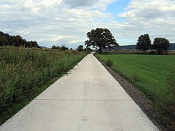
- Path condition: Roads are 95% asphalted or, in smaller areas, concreted. The railway cycle path is fine asphalt of the first quality, 3 m wide!
- Traffic load: Over 90% of the range from Neustadt respectively Schwalmstadt-Treysa up Bad Hersfeld are completely free of vehicles (the railway cycle path is complete). West of Neukirchen you have to cross the federal highway 254 (traffic lights). Because of the attractiveness of the path, many people use the cycle path in sunny weather in spring and summer, especially on weekends.
- Suitable bike: A bicycle with three 3 gears is sufficient on the railway cycle path alone, on the further route between Upper auditorium-Wahlhausen and Niederaula-Kleba you definitely need 7 courses, as it is partly very hilly with very short steep climbs.
- Family suitability: If the total length of 68 km (Treysa-Bad Hersfeld) is not too long, families can easily ride the Rotkäppchenland railway cycle path.
- Inline suitability: If you are still unsure about inline skating, you should only ride on the railway cycle path. Theoretically, however, one could do the entire stretch from Treysa to Bad Hersfeld ride with inline skates without any problems.
background


The route is officially called Rotkäppchenland railway cycle path. The information boards erected in 2012 were also set up under this name. Since the cycle path runs on the route of the former Knüllbahn, it is also occasionally called Knüllbahntrassenradweg designated.
The first two construction phases of the Railway cycle path were completed quite quickly by September 2009 (Riebelsdorf-Wahlshausen). Then there were ambiguities regarding the financing for the third and final construction phase. Therefore, the last section from Treysa to Riebelsdorf could not be completed until the end of May 2013. The last gaps were closed with the construction of the sections between Treysa and Wiera in 2018 and 2019.
getting there

With public transport
Main-Weser-Bahn stations (KBS 620) can be found in Neustadt (Hessen) (RMV), Schwalmstadt-Wiera (NVV) and Schwalmstadt-Treysa (NVV), as well as on the railway line Bebra-Fulda in Bad Hersfeld (KBS 610).
Where the Knüllwaldbahn used to go, today it roughly follows its course Bus route 470, which runs Monday to Saturday and, like all other bus lines along the Rotkäppchenland railway cycle route, as long as the operating situation permits. During the summer schedule, five bikes can be taken on the bike rack free of charge.
By bicycle
The corner points of the Rotkäppchenland railway cycle path are well connected to the national cycle network. This is how the Hess runs through Neustadt. Radfernweg R2 and the German Unity Cycle Route, by Schwalmstadt next to the Schwalm cycle path the Hessischer Radfernweg R4 and through Niederaula the Hess. Long-distance cycle route R1 (Fulda cycle route). In Bad Hersfeld there is also a connection to the BahnRadweg Hessen.
By car
Right at the start of the route there is the quite large, toll-free one 1 Haaßehügel car park at Treysa.
Nationwide variant from Kirchheim: Many drivers are familiar with this Kirchheim triangle. Not only do the motorways cross there, but there is also one of the first and largest truck stops in Germany with hotels, restaurants and petrol stations. Kirchheim is also passed by the R11 cycle path (e.g. in front of the AGIP petrol station), which you have to follow by bike to Oberaula (signs!). The route is pretty nice and the quality of the paths is high. Caution: do not follow the R18!
Route description
1st stage: Neustadt (Hessen) - Treysa: 11 km


The first stage of the Rotkäppchenland railway cycle path runs between Neustadt and Wiera mostly away from the roads (just a little bit east of Momberg on county road 15) before it runs on a cycle path between Wiera and Treysa along the federal road 454. The path has been continuously passable since 2019, signs and markings have been added and the guard rails have been technically retrofitted for the requirements of cycling.
The altitude difference is around 80 m in the direction of Neustadt-Treysa and around 45 m in the opposite direction.
- 1 Neustadt (Hesse) (240 m) - train station on the (KBS 620)
- ~
 ~> Those who start at the train station should also use the as a starting point 2 Junker Hansen Tower choose. With a total height of over 50 m and a diameter of around 13 m, it is the largest half-timbered structure in the world. From here you can take the Hindenburgstrasse and the Ringstrasse over the In der Aue road from the village along the Wiera river. Behind the sewage treatment plant, turn left and then right again up the small ascent. Shortly before the height you can see a group of trees with the Jewish cemetery on the left hand side. After you have passed the crossroads on the Riedstrauch (with seating area), it goes steeply down to the Riedmühle and the Trimpermühle.

- 3 Momberg (235 m)
- ~ ~> In Momberg, turn right onto the K 15. The Momberger Bruchwiesen nature reserve extends to the left of the sewage treatment plant. If you are lucky you can watch the water buffalo grazing here for nature conservation purposes. After crossing the Hardwasser you will find the Klauseborn after a few meters on the forest path that leads to the left directly behind it 4 . Around 40 liters of potable water flow out of the contained spring every minute. Continue on K 15 and turn left before the Main-Weser-Bahn level crossing.
- 5 Wiera (235 m) - train station on the (KBS 620)
- ~ ~> The cycle path through the field, which was newly laid out a few years ago, has some bends and blind spots. Therefore drive carefully. You roll down into town via Mengsberger Straße / L 3342. On the right is the train station with access to the platform in the direction of Marburg-Frankfurt. If you want to drive in the direction of Treysa-Kassel, you get under the bridge on the other side of the tracks to the platform. The cycle path to Treysa leads along the B 454 to the next town. On the way it runs on a part of the way over a former parking lot. Shortly before Treysa you cross the restored bridge over the Silberbach and cross the main road.
- 6 Treysa (225 m) is a district of Schwalmstadt with its own train station at the (KBS 620), where trains with free bicycles stop at least every hour, but also the ICE every two hours. Often mistakenly called Schwalmstadt The designated place is the actual starting point of the Rotkäppchenland railway cycle path, as the section on the Knüllwaldbahn also begins here. The center of Treysa is characterized by many half-timbered houses and is just a short detour north of the train station. Here you can go for a stroll or eat in one of the many restaurants, grocery stores or bakeries.
- ~ ~> You can get to the city via the cycle path to the right of the B 454a motorway slip road. Contrary to the official route over the Horschmühlenweg and the Ulrichsweg, the recommendation is to drive straight ahead over the Wierastraße into the city. Go straight over the roundabout and after crossing the Wiera on the right-hand side, you come a little uphill to Bahnhofstraße. On the left, you can enjoy the Schwalm's best currywurst in Wiegand's Imbiss. Up Bahnhofstrasse, keep to the cycle lane that begins on the right. If you don't want to go back over the Mainzer Bridge and at the end to the left on the Bahnradweg, you should take the opportunity to visit the old town with the historic half-timbered town hall and 7 Visit the ruins of the Church of the Dead.

2nd stage: Treysa - Wahlshausen: 36 km


The second stage of the Rotkäppchenland railway cycle path runs 95% of the time on the Knüllwaldbahn railway line, which has been expanded to a total of 36 km for cyclists and inline skaters and is 3 m wide asphalted. Except for crossing several streets, such as federal highway 254 (traffic lights), this stage is completely free of traffic. In between crossing the Schwalm cycle path and the Hess. Long-distance cycle route R4 the Rotkäppchenland railway cycle route. While up Neukirchen Buses even run on Saturdays, run between Neukirchen and Olberode, apart from a few school bus trips, no buses whatsoever, which is why you should always take tools with you in an emergency when driving on this route.
The altitude difference is around 230 m in the direction of Treysa-Wahlshausen and around 150 m in the opposite direction.
- ~ ~> Treysa is left for a short distance to the north-east of the bicycle road. Soon you have left the last houses behind you on the railway line through the Schwalmwiesen; to the north is the large Schwalm retention basin.
- 1 Ascherode (215 m) - From the 250-inhabitant district of Schwalmstadt you don't notice much because you drive past it to the north. Only the Schwalmtalstrasse has to be crossed; good bus connections to Schwalmstadt.
- ~ ~> Once you have passed the Schwalmtalstrasse, after a short bend you will reach Ziegenhain. Today there is a beer garden in the old train station.
- 2 Goat grove (215 m) - The former residence and district town today has about 4175 inhabitants and also has good bus connections. In another flood retention basin, directly on the railway line, is the glider flying site "Der Ring".
- ~ ~> To the south-west of the already mentioned glider airfield, you continue cycling not far from the Schwalm over another long straight past a fairy tale sculpture.
- 3 Loshausen (215 m) is the next place on the railway cycle path Rotkäppchenland, has a good 970 inhabitants and belongs to the municipality Willingshausen. There is a beautiful old bridge over the Schwalm very close to the railway line, which can also be seen directly from the railway line. In Loshausen cross the Schwalm cycle path and the Hess. Long-distance cycle route R4 the railway cycle route Rotkäppchenland and the bus routes operate 470 and 481.
- ~ ~> Behind the castle park and crossing the national road 3263, you drive through the Grenfftal past the Zella train station, where you have to cross the federal road 254 with the help of a traffic light, and continue cycling over a very long straight with two depressions not far from the Grenff , along a 21.9 km long right tributary of the Schwalm. The district road 111 is also passed and reaches the train station of Riebelsdorf.
- 4 Riebelsdorf (235 m) - 785 inhabitants large district of Neukirchen in Grenfftal on the federal road 454. The bus routes operate 470, 478 and 479 in the town center.
- ~ ~> Continuing on the railway line, you reach the edge of a small wooded area and drive south of the Rückershausen pond, which is definitely worth a small detour.
- 5 Rückershausen (240 m) - Much smaller district of Neukirchen with less than 200 inhabitants and the Rückershausen pond not far from the railway line. Used by the bus routes 470, 478 and 479 approached.
- ~ ~> The shady edge of the forest is left and you reach the city park of south of the meadow mill and north of the cemetery Neukirchen, from which it is only a few meters to the old train station.
- 6 Neukirchen (Knull) (250 m) - 7175 inhabitants large climatic health resort and Kneipp spa in the middle of the Knülls, Old town characterized by beautiful half-timbered houses. Also a good possible stage destination, as the last shopping opportunities are available Upper auditorium. Good bus connections in almost all directions and neighboring communities.
- ~ ~> Past the audience of Kurt Makowski you cycle leisurely uphill through the Grenfftal, which is here in a mostly open landscape.
- 7 Nausis (280 m) - The idyllic district of Neukirchen has a little over 300 inhabitants. The place is only sporadically from the bus routes 476 and 479 approached, there are benches on the railway line with a beautiful view of the town.
- ~ ~> First, the railway line follows the edge of the forest, before you cross the state road 3158 south of the cutting mill and continue slowly uphill.
- 8 Kleinropperhausen (290 m) - Quite a small district of Ottrau with a good 65 inhabitants, which even had its own small train station or stop. Today the place is rarely used by the Bus route 479 approached.
- ~ ~> If you continue on the Rotkäppchenland railway cycle path, you can see the Lenzenmühle and the Steinmühle in the valley of the already much smaller Grenff to the north, and there are several bus stops not far from the railway line. Nice resting place on the railway line near the stone mill.
- 9 Ottrau station (330 m) - The smallest district of the municipality Ottrau and about 2 km from this with about 30 inhabitants. The bus routes operate 474 and 479.
- ~ ~> You continue through an incision, now more strongly uphill over a longer curve; southernmost point of the railway line.
- 10 Gorizia (350 m) is another district of Ottrau with 370 inhabitants not far from the origin of the Grenff am Rimberg, incidentally, never had its own train station or stop at the Knüllwaldbahn, although it passes directly north of the village. The bus routes run here too 474 and 479.
- ~ ~> The railroad bike path is well secured by railings on both sides and you can reach the next town slowly uphill past benches; in between you cross the Grenff for the last time.
- 11 Weissenborn (385 m) with about 375 inhabitants had its own train station or stop at the Knüllwaldbahn and is now used by the bus routes 474 and 479 approached. Probably the oldest church is in the center of the village Ottraus.
- ~ ~> From the railway line you can now look at the route that has just been covered and cross state road 3161 at the edge of the forest, where a large new rest area has been created. Always nice looks in the Crumple.
- 12 Schorbach (400 m) - The last part of the municipality Otrrau on the railway line is over a kilometer away from it. The bus routes operate 474 and 479.
- ~ ~> Mainly through the shady forest you reach the highest point of the railway cycle path at an altitude of 420 meters at the Olberode train station, marked by a simple sign on a tree. At the same time, the watershed between Schwalm and Fulda is located here.
- 13 Olberode (420 m) - The high im has almost 400 inhabitants Crumple located district of the municipality Upper auditorium with temporary management of the station directly on the old railway line. Next to the bus line that has been running parallel to the railway line for a while 479 The bus line, which runs frequently, also runs here 470.
- ~ ~> Finally, you cycle downhill, winding around 80 meters in altitude, down to Hausen (is circled once), the longest descent in the direction of Treysa-Niederaula and a beautiful view all the way to Eisenberg.
- 14 Hausen (345 m) - the state-approved resort in Crumple has a little under 650 inhabitants and is served by the bus routes 383, 470 and 474. Schloss Hausen is not far from the railway line.
- ~ ~> If you want to combine your bike tour with a little golf, you can do so in the Oberaula Golf Club to do. Otherwise the next place can be reached quickly.
- 15 Upper auditorium (325 m) is the first place (municipality total of 3200 inhabitants) behind Neukirchen, in which one could also shop again. Several bus lines run here in different directions.
- ~ ~> One more straight line leads to Wahlshausen, the end point of the railway cycle path. It is exited via a steep asphalt driveway. Perhaps the railway cycle path will be continued at some point, who knows ...
- 16 Electoral houses (305 m) - A district of the municipality with a population of just over 360 residents Upper auditorium. Good bus connections, also back to Schwalmstadt-Treysa.
3rd stage: Wahlshausen - Bad Hersfeld: 30 km


The third and last stage of the Rotkäppchenland railway cycle path is usually well signposted as the R11. It is a good 145 meters downhill from Wahlshausen to the Fulda valley to Niederaula, or uphill in the opposite direction. The entire section is also suitable for racing bikes Bad Hersfeld suitable because you only cycle on asphalt farm roads. Between Niederaula and Bad Hersfeld you then drive on the also very well developed Hess. Long-distance cycle route R1 (Fulda cycle route) / Hess. R7 long-distance cycle path right next to the railway line that can still be used by trains. In Bad Hersfeld you would even have a connection to another railway cycle path, the Solztalradweg to Schenklengsfeld.
The vertical meters in the direction of Wahlshaus-Bad Hersfeld around 75 m and in the opposite direction around 180 m.
- ~ ~> From Wahlshausen with a beautiful view of the further route of the R11 now downhill on an asphalt farm road along the auditorium; you leave the Schwalm-Eder district and now drive through the district of Hersfeld-Rotenburg.
- 1 Gersdorf (280 m) - 150 inhabitants large district of Kirchheim. On the outskirts of the village the beginning of the R10a up to the Eisenberg; Several bus routes operate in the town center, including the Citizen bus* to Bad Hersfeld.
- ~ ~> You continue cycling in some bends to Frielingen, past a sports field near the auditorium.
- 2 Frielingen (270 m) - 385 inhabitants large district of Kirchheim, also operate here next to the Citizen bus* several bus routes to the surrounding villages and towns.
- ~ ~> Past a farm, directly along the auditorium, downhill through the area of the municipality Kirchheim.
- 3 Heddersdorf (260 m) - Directly on the bike path is the Radcafe of the Backfreunde Heddersdorf, which is located in a district of 200 inhabitants Kirchheim Life. Several bus routes after Upper auditorium, Niederaula and Bad Hersfeld.
- ~ ~> While you can still drive traffic-free along the auditorium after Heddersdorf, you have to go in front Kirchheim switch to a footpath and bike path along federal highway 454.
- 4 Kirchheim (Hesse) (240 m) with a total of 3760 inhabitants (municipality) is a good stopover for lunch, as you can find several fast food restaurants and cafes right on the Rotkäppchenland cycle path through the nearby Kirchheimer Dreieick. Partly good bus connections to the surrounding towns and communities.
- ~ ~> Through the industrial area you quickly reach the auditorium again, with which you cross under the federal motorway 7 and reach the next town.
- 5 Kleba (230 m) - The northernmost part of the municipality Niederaula has 240 residents and its own village community center. Several bus routes run through the village.
- ~ ~> Behind Kleba, follow the winding course of an asphalt farm road and reach the 880m Aula viaduct of the high-speed route Hanover-Wurzburg and a little later also the Fulda valley.
- 6 Niederaula (210 m) - The community Niederaula has a total of around 5460 inhabitants and is located in the middle of the Fulda valley. Several long-distance cycle paths meet in the village and there are good bus connections to the surrounding villages and communities.
- ~ ~> On the very new one Hess. Long-distance cycle route R1 (Fulda cycle route) you cycle over a mountain and first over paved, then later over concrete farm roads along the railway line.
- 7 Beiershausen (210 m) - The district of 275 inhabitants Bad Hersfeld is not driven through itself, but you drive directly past the former train station or stop. The bus routes operate 380 and 390.
- ~ ~> Continue without inclines to Asbach, always directly along the railway line. Sometimes a strong wind can hinder faster cycling here.
- 8 Asbach (205 m) is a district of 1455 inhabitants Bad Hersfeld. Worth seeing watermill with old water wheel in the Mühlestrasse. The bus lines stop in the center of the village 380 and 390.
- ~ ~> On the sidewalk (beware of oncoming traffic) of state road 3431 you cycle to Fulda.
- 9 Kohlhausen (205 m) has 340 inhabitants and is also a district of the nearby Bad Hersfeld. From the so-called "goose lawn" you have a beautiful view of the water flowing past in the Fulda; to Bad Hersfeld, Niederaula and Kirchheim perverts the Bus line 380.
- ~ ~> Slightly curvy along the banks of the Fulda along paved paths through the test fields of the Eichhof agricultural center. When driving across the grounds of Eichhof Palace, it is worth taking a look at the half-timbered courtyard, which is well worth seeing.
- 10 Eichhof (205 m), also Eichhofsiedlung, is a district of 1065 inhabitants Bad Hersfeld. The biggest attraction is the Eichhof Castle directly on the bike path, which has been a branch of the "Landesbetriebes Landwirtschaft Hessen (LLH)" since 1965 with the name "Landwirtschaftszentrum Eichhof", as well as a branch of the Fraunhofer Institute for Wind Energy and Energy System Technology since 2010. Since 1986, mainly comedic plays have been performed here on the second open-air stage of the Bad Hersfeld Festival.
- ~ ~> Along the Fulda, one crosses under the federal autobahn 4 and the federal highway 62, before crossing the Fulda south of the spa park and cycling along this through the Fuldaaue. The Bad Hersfeld train station (KBS 610) can finally be reached via the local cycle route network.
- 11 Bad Hersfeld (200 m) - The festival and spa town Bad Hersfeld, also Salzburg of the north, is the end point of the Rotkäppchenland railway cycle path. The monastery ruins in the city with a total of 28,770 inhabitants, the largest Romanesque church ruin, are particularly worth seeing Europe applies and in which the annual Bad Hersfeld Festival is performed.
* Kirchheim citizen bus: separate tariff; Bicycle transport unclear.
security

As a cyclist, you have the right of way at almost all intersections on the core of the cycle path. This excludes intersections with federal, state and district roads and the intersection at the Freudenberg company in Treysa.
A good solution to the crossing problem was found here by dispensing with jostling bars: a stop sign and separate lanes secure the crossing. If someone continues straight ahead, lost in thought, he will be "woken up" by the cobblestones in the middle of the path. The paved island is long enough that there is enough time to brake before it is crossed. In addition, outside of the picture there is a "warning sign" with the addition "Stop in 50 m." Here there is no distraction from panniers stuck on the jostling grille and the cyclist can fully concentrate on the crossing traffic!
literature
- KB Kurhessisches Bergland Schwalm-Eder-Kreis - topographic leisure map 1:50 000, ISBN 978-3-89446-296-3 , 9.50 €, published jointly by Touristik Service Kurhessisches Bergland e.V., district committee of the Schwalm-Eder district and the Hessian State Office for Soil Management and Geoinformation (2008). Note: Since the railway cycle path was not yet completed in 2008, it is not shown on the otherwise very good map, but rather the railway line, which you can easily find your way around.
See also
Do you feel like cycling more along the railway lines? Other rail bike paths are listed here.
Web links
- detailed route information with pictures Bahnrassenradeln.de
- Information and leaflet from the Rotkäppchenland tourism service to the way
- Extensive route information (including restaurants, GPS files, zoomable maps) on the ADFC Schwalmstadt
- the railway line on Forgotten paths
- Route portrait in the film of the HR television, Experience Hessen: On the bike through the Schwalm