&groups=Maske,Track,Aktivitaet,Anderes,Anreise,Ausgehen,Aussicht,Besiedelt,Fehler,Gebiet,Kaufen,Kueche,Sehenswert,Unterkunft,aquamarinblau,cosmos,gold,hellgruen,orange,pflaumenblau,rot,silber,violett)
The approximately 340 km long Danube cycle path section Vienna - Budapest leads to the Danube of Vienna above Bratislava to Budapest.

On this route you get to know many places with architectural and atmospheric memories of theDanube Monarchy know. The magnificent Austrian capital Vienna, the easternmost part of Lower Austria with the pretty towns Orth on the Danube and Hainburg, the cozy Slovak capital Bratislava, the north-west of Hungary with the cities worth seeing Gyor, Tata, Esztergom, Vác, Szentendre and the fascinating Hungarian capital Budapest invite you to linger. In Hungary Food, drink and accommodation are inexpensive, so that nothing stands in the way of a longer stay even on a tight budget. The weather in Hungary is usually sunny and warm, which makes up for some of the inadequacies of the route. Anyone who relies on covering a stage by ship every now and then has to be disappointed. There are seldom moorings. The cruise ships almost exclusively travel long-haul routes.
Route profile

- Length: about 340 km
- Signposting: Lower Austria: R6, Hungary: Blue field with a white circle of stars, in the middle a 6 (for EuroVelo 6).
- Slopes: There are no major inclines. Sometimes, however, there is a strong headwind.
- Path condition: Very good, mostly paved bike path between Vienna and Čunovo. In Hungary about 70% asphalt or concrete pavement. These paved sections are sometimes very bad despite the asphalt, full of holes, cracks, edges and bumps. Partly soft gravel in which the tires sink. Partly stuck sand and gravel paths. Partly field and forest paths with deep mud holes and puddles.
- Traffic load: There is a separate cycle path between Vienna and Čunovo, far from road traffic. Between Čunovo and Esztergom, longer stretches without a cycle path on busy roads. Own bike paths between Esztergom and Budapest, mostly far away from traffic and in good condition.
- Suitable bike: Normal stable touring bike. It is advisable to take a spare hose with you, as all kinds of sharp small parts, especially in cities, can cause a "flat".
- Family suitability: As longer distances have to be covered on very busy roads, the route between Čunovo and Esztergom is unsuitable and dangerous for children. While the huge trucks usually keep a certain distance from the cyclist, the long coaches race right past the cyclist, so to speak, which is also on the nerves of adults. Numerous crosses on the roadside bear witness to the tragic end of such overtaking maneuvers.
- Inline suitability: The cycle path between Bratislava and Čunovo is wide and excellently paved. There is a lot of inline traffic here. The bike path at Esztergom and Nagymaros is also good and can be used by inline skiers. In and around Budapest, the bike path is in unimaginably poor condition despite the asphalt.
background
The Danube Cycle Path is one of the most popular international cycle routes and has long enjoyed cult status among pedal knights. The section from Vienna to Budapest is less busy than the route to Vienna, but there are still 5000 to 10,000 cyclists a year, and the trend is increasing the route because of its diverse landscape and culture. The poor or non-existent bike paths are compensated for by low prices. The route can be covered in three to seven daily stages, and fewer daily stages are possible for ambitious riders. You don't need special bikes The cycle path along the Slovak-Hungarian border is pretty good. If you always want to ride on the dike, it can sometimes be uncomfortable, but often parallel, quiet country roads are a good alternative.
preparation
There is none on this section of the Danube Cycle Path Bike service more like you are used to from Austria and Germany. So it might be advisable to take some spare parts with you. If you also want to go camping, you should make sure beforehand on the Internet that the campsite on the map really still exists. A map may be dispensable between Passau and Vienna, but that does not apply to this section. The signage is becoming more confusing and partly consists of painted yellow "C" which is sometimes not easy to see or cannot be clearly interpreted. Anyone who has a GPS can download OpenStreetMap maps free of charge [www.garmin.openstreetmap.nl]. A good map or a bike tour book about this section is essential, a small compass is a good service. Sufficient amounts of Autan are also essential. because otherwise you will be driven crazy by the thick swarms of mosquitoes along the Danube - if not eaten - at least! It is cheap to take a yellow or orange protective vest with you, which you then - like the Hungarians do - on the Stretches that the bike path runs on busy roads attracts; it is very useful to learn a few basic sentences in Hungarian.

getting there
Train and bus
With the train that's not a problem as long as you have a reservation for your bike. Especially in summer, when everyone wants to pack their bikes on the train, the stress should not be underestimated. Since some trains have a really small number of parking spaces, reservation is a must bus would be an alternative. Write to the tour operator beforehand whether he will also transport bicycles. One possibility for the return journey: the bus company Orangeways [1] offers bus trips from Budapest, bus station Népligeti megállóhely FTC-Albert Flórian Stadium 1 to Berlin, Dresden and Munich for 33 € per person, bike 7 € (2013), three days a week, bookable online.
From Berlin via Dresden to Budapest and back there is even a train with bicycles, which requires a reservation.
There are also special bicycle trains between Prague and Budapest. However, you have to reserve seats for yourself and your bicycle on these trains at least one day in advance. It has been reported by travelers that the train staff (!) Have stolen luggage, e.g. cameras, from them on these trains In addition, these trains are sometimes delayed by up to 2 hours.
From May 1st to October 26th, a special bike train runs from Passau to Vienna once a day [2]This train arrives in Vienna at 9:29 p.m. at Franz-Josefs-Bahnhof. The next campsite on the Danube Cycle Path in Vienna is on the New Danube behind the Prater Bridge, 10 km from the train station. Another option is to go to the station beforehand beautiful Hotel Bellevue, which is located right next to (on the west side) the Franz-Josefs-Bahnhof and is very well equipped with storage of bicycles in a closed garage on the ground floor for cyclists to book a room online and with credit card Online booking at this hotel you can get a double room (without breakfast) for € 60 (2013), but if you order the room by phone or go directly to the hotel, you will be faced with fantastic prices (€ 100 and more) and take the risk that the hotel is full.
By bicycle
If you want to start in Germany, you should start in Passau at the latest. The Guide Danube Cycle Path (Passau - Vienna) describes this stage through Austria.
rental car
Rental cars are a very expensive solution. Information from several providers showed that they do not want the car to be returned in another country and clarify that with the price.
Route description with sights
If you want to sleep in a tent, you should choose the Hungarian variant, where there are more campsites than on the shorter Slovak route. For campers, it should be noted that by far not every campsite shown on a map still exists. There is even the case that all the signs to the campsite are still there, but the site itself has been abandoned for more than 10 years. But on the Slovak side it is not a problem to get a room. Almost in every village, deep inland, there are signs saying "Rooms are free". Rooms are often slightly more expensive and much more comfortable than most campsites.
Note: For a variant Vienna - Bratislava see here: Vienna-Bratislava cycle and hiking trail (variant)
Vienna - Hainburg: 52 km
See also: Alternative route Vienna-Bratislava through Marchfeld.


In front of the Franz-Josefs-Bahnhof 1 While standing, turn left (to the east) on the cycle path over Julius-Tandler-Platz and Alserbachstrasse to Friedensbrücke 2 Over the Danube Canal. Behind the bridge, immediately right along the canal to the third street, Perinetgasse, along this, then right to Obere Donaustraße and then left to Gaußplatz, across from Wasnergasse and immediately right into the Augarten3 Past the huge flak tower through the Augarten to the southeast to Heinestrasse and along it to the Praterstern, to the train station and under the railroad tracks to the Prater4 On the straight main avenue through the Praterpark to the autobahn 5 Here you are again on the Danube Cycle Path. Do not go under the motorway, but first turn left along the motorway for a short distance (about 200 m), then immediately right up diagonally (signposted Danube Island) 6 and under the one motorway exit onto the cycle path below the motorway bridge (Prater bridge). If you cross the Danube completely on this cycle path, you come to the camping site. From the Vienna camping site ("Aktiv Camping Neue Donau") you are right back on the cycle path and en route towards Slovakia. The landscape becomes lonelier, although there are still cyclists on the way. Sometimes you come across groups of cyclists who are all organized along the dike with the same bike and the same saddlebags, otherwise there is no comparison to the "bike highway" Passau-Vienna. About 6 km after the Prater bridge, the bike path leaves the dam and runs further parallel to the Danube on the Raffineriestraße through the oil port 7 After the port back to the dam and well-developed and always signposted on the dam on the left side of the Danube. 12 km further the path follows a small detour Schönau, where he at Hermis Radlertreff 8 meets, a sausage stand with beer garden right on the way with excellent currywurst (and other delicious dishes), freshly baked crusty bread and cold draft beer, clean, comfortable toilets and convenient options for sitting in the sun or under the roof when it rains. It is always open, no day off.
Important note: Due to renovation work on the flood protection dam, the Danube Cycle Path between Schönau an der Donau and Stopfenreuth will be closed from October 2nd, 2017 until the end of 2020. A diversion route through the villages in Marchfeld is signposted. The following section is therefore not 100 percent accurate:
After 7 km you will come to the junction Orth9 , a pretty town with many good places to stay. Drive about 8 km further at the southern end of the castle park Eckartsau (one of the Marchfeld castles) and after a further 8 km you reach it Stopfenreuth with an inn right on the way. Here you can go down to the Danube, where there is a campsite 10 which unfortunately has neither toilets nor drinking water. This is where the signposted diversion route meets the main route of the Danube Cycle Path.
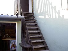
Cross the 2.2 km long Hainburg Danube Bridge to the right bank of the Danube, where you can go back if you are interested Petronell-Carnuntum drive where there is a campsite and the very worth seeing and interesting archeology park Carnuntum11 Or you continue in a right loop down to the Danube, directly along the right bank of the Danube, and reach after 7 km Hainburg12 Right next to the first houses in Hainburg there is a small garden house right on the bike path (Hollitzerallee 28), where you can stay overnight very cheaply.


Hainburg - Bratislava: 16 km
Route map Hainburg - Bratislava
The official Danube Cycle Path from Hainburg to Bratislava always goes along the road, which is a pretty boring and very hot affair in summer. If you always drive along the Danube in Hainburg, you end up in front of a rock face with a gate-like hole in it. This rock gate 1 is the beginning of an extraordinarily romantic, shady, interesting and beautiful path to Bratislava. Unfortunately, this path is closed to cyclists for some inexplicable reason, perhaps on the initiative of some fishing clubs or other egoists who try to break the shores of the seas here, as everywhere in the world To reserve lakes and rivers for their private interests. However, one meets again and again cyclists and sometimes even cars, so that there are probably no objective reasons against its use. This forest path leads almost all the time in the shade, past the remains of a former one Tavern (Noah's Ark) 2 , at a castle ruin (Rötelstein) with a great view over the Donauau 3 , at beautiful bathing spots always right on the banks of the Danube to Bratislava. From Hainburg to Bratislava you need about three hours on this way. Once, at the castle ruins, you have to push the bike a short distance very steeply uphill and then downhill again - otherwise always flat, solid forest floor, small spots with coarse gravel, solid gravel. Shortly before Bratislava, this illegal variant reunites with the official route, which actually leads past the city. If you want to go into the city center, you cycle - on a separate cycle path - over the second big bridge 4 The first is the motorway. After the bridge, drive 50 m away from the Danube along the continuation of the bridge and you will find yourself in the square below the Cathedral of St. Martin 5 This is where the old town begins and its main street, the Panská, in Bratislava you can also pay with euros. The prices drop noticeably here compared to the Austrian standard. So it's a good way to get a room. Tip: look for campsites on the Internet. Cards often turn out to be unreliable. An inexpensive and quiet place to stay is the Antic Caffé restaurant right at the main train station in Bratislava 6 . 35 € the double room, shower and toilet in the corridor, without breakfast. The bicycles can be put in the hallway. Breakfast is available for 3 € (2013). You can eat very well in the trendy bar "downtown backpackers" 7 on Panenská Street, you are right in the middle of youthful Bratislava. It is also a hostel where you can stay overnight. Bratislava is a very cozy, friendly and youthful city. You should set aside at least a full day for them.
Bratislava - Esztergom - Slovak side: 166 km
After Bratislava you have to decide whether you want to continue on the Slovak or the Hungarian side of the Danube, a choice that cannot be easily reversed as the wider the Danube gets, the fewer bridges there are and there are ferries not very often either.
The Slovak route is the shorter one. For the most part, it leads along paved dykes along the river, which can get a bit boring in the long run. On the other hand, you make good progress, and two crossings of the Danube on hydropower plants offer something to be amazed at. Overall, the Slovakian bank of the Danube is very sparsely populated, with sometimes large distances between the villages. However, there are small, inexpensive grocery stores in most villages, but they are not always easy to find. Happy to ask in the locality, the people are very helpful.
From Medved'ov the cycle path on the dike to Komárno (approx. 40 km) consists only of gravel that is very difficult to drive on. There is also no bridge on this section, so you can no longer simply switch to Hungary. It is therefore advisable to leave Slovakia in Medved'ov and drive on the Hungarian side. There are also more campsites there. From Komárno to Sturovo, the cycle path is again very well developed and leads through a more beautiful landscape. There are many small, secluded pebble beaches on the Danube where you can regenerate. You also pass the ruins of an old Roman fort. It is therefore strongly recommended to drive back on the Slovak side from Komárno and take the bridge to Esztergom in Sturovo, which also rewards with a spectacular view of the basilica.
The Hungarian variant is said to be more beautiful and about the city Gyor lead the city Esztergom is impressive. Especially the beautiful cathedral, which you can see from afar. Otherwise there is apparently only a bit of the old town. But if you want to go shopping, you have to go back to Štúrovo. It's not far, just cross the bridge and you're done You can also change money at the bridge and get a good rate there. Hungary's currency is the Forint (HUF). Sometimes you can also pay in euros, but that's actually undesirable. Tip: Better to change too much money here than to be constantly served with really bad exchange rates afterwards.


Bratislava - Györ - Hungarian side: 50 km
To continue on the Danube Cycle Path, cross the bridge again to the right side of the Danube, where a super smooth asphalt wide dam path begins, with crowds of inline skaters and cyclists cavorting up to Čunovo. It is a true folk festival. Every 300 m there is a booth with snacks and drinks.
Anecdote (really happened):
An elderly German is sitting at one of these booths with a beer and looks ecstatically at the pretty young Slovak women who are whizzing past on their inline skates. Finally he sighs and mumbles to himself: "Somehow the women here are slimmer look like hippos. "
This paradise is 17 km long to Čunovo. There it suddenly came to an end. Here is the point of decision 1 : To the left it goes to the Slovak variant, to the right to the Hungarian variant. Since the Hungarian variant is described here, you drive to the right, i.e. to the west, through a small park until you come to the Schengenska, which is like its name already suggests, leads to the limit 2 After about 600 m you come to the Slovak-Hungarian border and the Schengenska becomes the road to Rajka. If you stay on this road, you will automatically reach the main square in Rajka 3 with a bank to change money, which is absolutely necessary because generally only forints (HUF) are accepted, and shortly after that a good restaurant. It is also the road that then leads to Dunakiliti, the variant that is described here. The signs of the official Danube Cycle Path lure cyclists to the right (west) past the main square through side streets. Buy the bare essentials in the grocery store, because from now on it goes through tiny villages. On the road to Dunakiliti. Unfortunately it is quite busy. You can use dirt roads towards the Danube, but you run the risk of getting lost in the numerous dead water. The bikeline maps are only very unsatisfactory in Cikolasziget 4 There is a small bar where you can rent a rather dingy apartment above the bar from the landlady, which can be reached via a steep, crumbling wooden staircase. In this village you can also reach the Danube dam - before you rub it in with Autan Otherwise panic due to the attack by swarms of mosquitoes. The Danube dam offers a wonderful view of the Danube floodplains and the surrounding area - but - it is freshly sprinkled with a thick layer of soft, round gravel. After 3 km you have the impression that you have driven 20 km. Hopefully someone in the EU can support the Hungarians to pave this wonderful, well-developed dam !!! So either on the dam or on the road via Püski, Kisbodak, Dunaremele, Lipot to Hédervar, where this variant near the Danube joins the main path. There are always campsites and grocery stores in the small villages. By the way: If you speak to Hungarians in German or English, they pretend to be Not able to understand and speak at all, but if you break the few words in Hungarian that you have laboriously learned against the energetic resistance of your own brain, then the Hungarians suddenly smile and speak super German or English. From Hedervar to Asványráró, continue to speak Dunaszeg. On this route there is a cycle path along the road. In Dunaszeg again decision: continue cycle path along the road or soft gravel au f the very romantic dam along the Mosoni Duna (Little Danube) - everyone to his taste. Whoever chose the dam should stay on it and not, as the variant wants, return to the main path shortly before Györ! The dam path turns into the promenade of Györ 5 and here is the folk festival atmosphere again: masses of young people, dragon boat races on the Danube, stalls, kiosks, etc. The first bridge is the Jedlik Ànyos Hid (hid = bridge). When you drive over this bridge, you have to keep to the right, to get to the center of the old town of Györ and cross the Rába Ketös Hid (the bridge over the Raab). If you turn right after the second roundabout, you will come to Lakatos ut (ut = street) is the Hotel Isabell 6 , where you can live quite expensive (70 € per night for a double room with breakfast, 2013) but very nice and quiet. There are cheaper options to stay in the center of Györ. Györ is a beautiful, very lively city that you are looking for should take at least a full day.
Györ - Komárom / Komárno: 55 km
This route runs on cycle paths, which mostly run along the railway line, far away from road traffic. From time to time you can see horse-drawn carriages and horse-drawn carriages from the nearby Stud Bábolna, whose drivers do all sorts of tricks, e.g. standing on their backs while driving a chariot. Between Györszentiván and Nagyszentjános one can go through a dirt road along the railway line 1 Take a shortcut and avoid the road via Böny. There is a good restaurant right at the Nagyszentjános level crossing. The sandy pothole road sometimes gives way to the field. When it rains it can get muddy.Komárom has a fortress, a thermal bath, a campsite and an inexpensive hotel "Karat" (€ 30 double room with breakfast, 2013) 2 in Czuczor Gergely street at the level of the thermal baths.

Komarom / Komárno - Tata: 22 km
From Komárom the Danube Cycle Path goes directly along the Danube to Esztergom. But the small detour to the pretty town of Tata is worthwhile. The bikeline guide describes two routes to Tata, both sweaty and frustrating because, while you are slow and laboriously torturing one of the many inclines, cars constantly whizzing past you at high speed. All these inclines are completely unnecessary, as Tata is only slightly higher than Komárom. The best, shortest and almost no incline to get to Tata is if you Leave Komárom on the main Danube Cycle Path and continue along this path via Szöny, Nagykolonia to the first houses of Almásfüzitő. On the left side are the first two houses, on the right side behind the railway line there is a small wood. Behind the wood goes the street Hunyadi Janos ut 1 Direction southeast via Almáspuszta 2 , Naszály 3 to Tata. This road is well paved, has very little traffic, leads through a tranquil landscape with ponds and gardens and after 12 km reaches Tata with almost no incline. If you don’t like to torment yourself, you can take it to Tata and back again. In Tata the road leads to the large church of the Holy Cross, past it further and further south-east through a small park to the bank of the Öreg-tó 4 Always stay on the promenade in a clockwise direction around the lake, first through the castle grounds. Then overnight accommodations appear directly on the waterfront, e.g. the candy-pink Hotel Cassablanca 5 and the very nice Pension Monika 6 (€ 50 per double room with breakfast, 2013), the large rooms of which have balconies with a view of the lake.
Komarom / Komárno - Esztergom: 60 km
From Komárno on the Slovak side, the cycle route first goes along the Danube past the fortress (Fort Monostor) and then up the river Váh for a kilometer. Across the bridge you can reach the Danube dam with a smooth asphalt road with almost no interruptions to Čenkov. From there it goes over a wide, moderately busy road with fast cars to Mužla, where a "Western Saloon" can serve refreshments on the hill. The rest of the way to Esztergom is a breeze. A visit to the huge thermal baths in Štúrovo is worthwhile, but there is no monitored parking space for bicycles.
Tata - Esztergom: 44 km
From Tata back on the pretty road via Naszály back to Almásfüzitő. Now one of the most disgusting stretches of this section of the Danube Cycle Path begins. From Almafüzitő to Nyergesújfalu one is forced to cycle without a cycle path on road no.10, which is very busy with large trucks and long coaches .That's about 25 km. In the villages you can simply use the pedestrian paths as a cycle path, but on the open road you often only have to switch to the narrow hard shoulder when a coach comes up close again. The Hungarians who do this Ride the route by bike or scooter, all have yellow or orange protective vests. From Nyergesújfalu there is a very nice, well-developed and paved bike path for 10 km. This unfortunately ends 6 km before Esztergom and forces you to take the busy road no 11. After you have endured this about 3.5 km, there is a junction towards the Danube behind (!) A large gravel works 1 and after about 300 m in front of another gravel works a dirt road parallel to an arm of the Danube on whose dam you come to Esztergom. If you take one of the branches that appear before, you end up inside the same large gravel works behind a high fence and a locked gate bridge 2 Over the Danube arm to the left to the main arm of the Danube. Now you can see the famous basilica and on the right side the very nice and comfortable campground 3 from Esztergom. It is worth staying two nights at the campsite in Esztergom and exploring the city on foot. The basilica can be reached from the Danube side via a romantic narrow staircase 4 From the city side you can even go up with a lift. From the square in front of the basilica a train leaves for sightseeing. The old town of Esztergom is located southeast of the basilica and has a large main square, Széchényi tér, 5 Surrounded by magnificent buildings, there are small shops in the partly unpaved streets and narrow alleys behind the buildings in the main square and there is a market there in the mornings.


Esztergom - Szentendre: 46 km
From Esztergom a very nice bike path leads along the Danube. When it ends, you can - depending on the flood - drive a good bit further on a forest path along the Danube 1 .
Finally you have to go back to the busy road no. 11, but only for 1 to 2 km, and then there is a path to the Danube again 2 and further along the river to the ferry to Szob 3 The ferry leaves every hour. So you put on the left side of the Danube. Here on very good bike paths along the Danube through impressive rocky landscapes via Zebegény to Nagymaros.
From Nagymaros there is a ferry every hour 4 to Visegrád. Man kann in Nagymaros z.B. 500 m hinter der Fähranlegestelle in der hübschen alten Villa Szent Istvan Fogado 5 ein Zimmer nehmen und dann ohne Fahrrad zur Besichtigung von Visegrád mit der Fähre übersetzen. Natürlich gibt es auch in Visegrád zahlreiche Übernachtungsmöglichkeiten.
Der Donauradweg geht sehr schön angelegt und ausgebaut auf der linken Donauseite von Nagymaros weiter über Veröce nach Vác. Man lasse sich nicht verleiten, etwa weil die Fähre grade zur Abfahrt bereit steht, an Vác vorbeizufahren!Die Fähre geht auch hier stündlich.
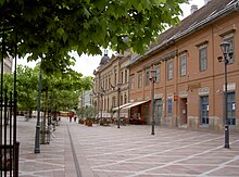
Vác ist eine wunderschöne, ganz ruhige und heitere Barockstadt. Der Hauptplatz 6 , den man nach einigen Metern erreicht, wenn man von der Fähre die Straße von der Donau weg hinaufgeht, ist der einzige barocke Platz in Ungarn und verströmt mit seinen kleinen Geschäften und Restaurants die barocke Atmosphäre des Müßiggangs und Lebensgenusses. Gleich hinter (südöstlich) dem barocken Hauptplatz befindet sich ein lebendiger, ganz urtümlicher Markt.
Mit der Fähre hinüber auf die Szentendrei Sziget (Insel) und auf ganz ruhiger Straße nach Tahitótfalu. Über die Brücke wieder von der Insel hinunter und rechts der Donau weiter. Hier braucht man nicht, wie im bikeline angegeben, die Straße zu fahren, sondern kann gleich nach links ans Flussufer ausweichen und auf hübschen Parkwegen 7 bis nach Leanyfalu gelangen, wo der reguläre Radweg weiter geht.
Auf dem Radweg nach Szentendre, wo gleich am Ortseingang der schön auf einer Insel gelegene ruhige und komfortable Zeltplatz 8 auf die RadlerInnen wartet.
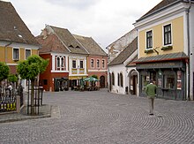
Einige Kilometer vor Budapest gibt es ein Dorf mit dem Namen Szentendre. Hier gibt es Souvenirs zu kaufen. Eben lauter typisches Zeug, schöne Taschen aus Leder und bunte Kleidung, Salami und bemalte Holzsachen. Wer jemandem was mitbringen will, sollte unbedingt hier pausieren. Das touristisch voll erschlossene Stadtzentrum von Szentendre ist allerdings noch etwa 2 km vom Zeltplatz entfernt. Am Hauptplatz, dem Fó tér, 9 befindet sich hier zwischen all dem touristischen Gimmick eine sehr schöne orthodoxe Kirche. Auf dem Zeltplatz, wird man sehr freundlich mit Informationsmaterial über Budapest versorgt und auch bei jeglichen Besichtigungsvorhaben unterstützt.
Szentendre − Budapest: 24 km


Von Szentendre führt der Radweg sehr romantisch weiter am rechten Donauufer nach Budapest und in die Stadt hinein.Er ist asphaltiert, aber man kann sich kaum vorstellen, dass ein asphaltierter Weg so schlecht sein kann, wie dieser - voller Löcher, Buckel, Spalten, Risse.Über Csillaghegy gelangt man nach Romaifürdö 1 .Wenn man nicht schon etwas in Budapest gebucht hat oder sich dort auskennt, sollte man unbedingt hier in Romaifürdö bleiben und nicht weiter in die Stadt hineinfahren, weil das sonst mit Sicherheit ganz fürchterlich frustrierend wird.Romaifürdö erkennt man daran, dass hier ein blaues Hotelschiff, die Aquamarina, an einem Steg liegt.Am Ufer befinden sich eine Menge Buden, Tische und Stühle.Auf der Aquamarina kann man ein sehr komfortables Doppelzimmer mit Frühstück für 45€ bekommen und auch die Räder sicher unterstellen.Wenn man dort, wo die Auamarina liegt, senkrecht von der Donau weg geht, gelangt man in eine Siedlung mit günstigen Übernachtungsmöglichkeiten;z.B. gleich in der ersten zur Donau parallelen Straße, der Nánási ut, findet man in einem Café die Pension Fontana 2 , DZ mit Frühstück 50€ (2013).Geht man noch etwa 200 m von der Donau weg, gelangt man zum Campingplatz "Romai Camping" 3 , wo man auch kleine Holzhütten mieten kann.Von Romaifürdö gelangt man ganz wunderbar ins Zentrum von Budapest, nämlich auf zwei Weisen:
1. Romantisch und beschaulich:Wenn man durch das Hotelboot Aquamarina hindurch geht, kommt man zu einer Bootsanlegestelle, wo etwa im Stundentakt von morgends 9 Uhr bis nachmittags 17 Uhr Linienboote nach Budapest fahren. Die Haltestelle im Zentrum heißt Petöfi tér. Auf der Fahrt gleitet die ganze spektakuläre Silhouette sehr fotogen an den Fahrgästen vorüber. Die Fahrt von Romaifürdö bis Petöfi tér dauert etwa eine Stunde und kostet 750 HUF (etwa 2,50€)
2. Schnell und effektiv:Etwa 1,5 km von der Donau und dem Hotelboot Aquamarina entfernt befindet sich so eine Art S-Bahn, auf ungarisch HEV. Die Station heißt natürlich auch Romaifürdö 4 . Mit dieser Bahn gelangt man für 250 HUF (nicht ganz 1 €) in 10 Minuten ins Zentrum.
Und hier eine gute Nachricht für alle Grufties: Für EU-Bürger ab 65 Jahre sind alle öffentlichen Verkehrsmittel, auch die Linienschiffe, kostenlos! (nicht vergessen, den Ausweis mitzunehmen!)
In Romaifürdö versammelt sich am Abend Jung und Alt aus Budapest.Eine unheimlich bunte Gesellschaft, die so vielgestaltig und so zivilisiert friedlich ist, wie man es kaum für möglich hält.Man isst hier "Hal", das ist gebackener frischer Fisch, so lekker, wie es ihn nirgend woanders gibt.Es gibt alte Herren, die aus dem vorigen Jahrhundert irgendwie übrig geblieben zu sein scheinen und die aus purer Lust Geige spielen.Es gibt Bands, die ganz unaufdringlich eine Vielfalt von Musik spielen, sodass jeder seinen Spaß daran finden kann.
Wenn jemand nun diesen guten Rat in den Wind schlägt und trotzdem weiter dem Radweg in die Innenstadt folgt, dann wird er etlichen Gefahren begegnen.Einmal sind die Radwege und Straßen von Budapest mit kleinen und kleinsten Scherben, Drähten, Stacheln und Nägeln übersät, sodass ein "Platter" fast unausweichlich ist.Dann ist die Beschilderung sehr verwirrend.Speziell bei der Brücke zur Obudai sziget (Insel direkt oberhalb der Margaretheninsel).Dort weist ein Radweg-Wegweiser völlig unlogisch von der Donau weg.Hält man sich nicht daran, landet man auf einer ganz engen, schrecklich befahrenen Schnellstraße mit einem ganz schmalen Seitenstreifen (ca. 50 – 30 cm), auf der Radfahren verboten sind.Merkt man das, bitte sofort umkehren! Der Seitenstreifen wird immer schmaler!Man kann in diesem Fall einfach über die Brücke auf die Insel fahren und weiter donauabwärts.Am Ende der Insel gibt es wieder eine Brücke zurück ans Ufer und auf den Radweg.Oder man geht durch die S-Bahnstation, über die Geleise. Hinter den Geleisen verläuft wieder der Donauradweg.
trips
security
Mit der Sicherheit gibt es keine Probleme.Man fühlt sich auch nie unsicher.Die Menschen sind nett und freundlich und auch sonst muss man sich wohl nicht besonderes wappnen.Es gibt sehr viele Hunde, auch sehr große, die einem manchmal etwas Angst machen können besonders, wenn man sie in einsamer Gegend trifft.Meistens befinden sie sich jedoch sicher hinter Gartenzäunen.Ein griffbereit am Fahrrad installiertes Pfefferspray könnte vielleicht eine Hilfe sein.
Sprachen
Nach Wien ist man schnell in der Slowakei und hat daher gute Chancen, dass man mit Deutsch durchkommt. Allerdings macht man dort auch mit Englisch gute Erfahrungen.Wer eine dieser Sprachen beherrscht kommt gut durch.In Ungarn bestanden früher nahe Kontakte zur DDR.Es gibt deshalb vorwiegend ältere Leute, die früher einmal in Ostdeutschland waren.Diese sprechen dann offensichtlich gerne Deutsch mit einem und sind hilfsbereit und auskunftsfreudig.Jüngere Leute sprechen im Allgemeinen gut englisch.Günstig ist es, die nötigsten Sätze auf ungarisch zu beherrschen.Äußerstes Minimum: Guten Tag (jo napot), Auf Wiedersehen (viszontlátásra oder kurz: viszlat) und Dankeschön (köszönöm).Es ist auch ein Akt der Höflichkeit, wenigstens die allernötigsten Worte des Gastlandes zu kennen.Auch wir erwarten das, von den Fremden, die zu uns kommen.
cards
Es gibt verschiedenes Kartenmaterial zu kaufen. Das bekannteste ist wahrscheinlich das bikeline-Buch in 5 Teilen. Inhaltlich ist dieses Werk voller Informationen und Alternativrouten. Wer einfach nur eine leichte Karte sucht, ist hiermit nicht gut bedient. Sonst ist dieses Ringbuch stabil und hat ein praktisches Format.Im selben Format, aber abgespeckter ist die Ausgabe von Galli. Allerdings ist auch die nicht frei von Kritik was die Aktualität angeht.Für die GPS-Besitzer bietet es sich natürlich an, sich eine detailierte Karte herunterzuladen und den passenden Track. Das geht auch kostenlos. Bei [www.garmin.streetmap.nl] kann man sich die Kacheln für sein Garmin-GPS gratis herunterladen. Wer noch den passenden Radweg als Track sucht findet ihn hier [3]. Die kmz-Datei muss man allerdings noch in eine gpx-Datei konvertieren [4].Das perfekte Material gibt's halt nicht. Jeder muss sich sein Kartenmaterial selber nach seinen Bedürfnissen zusammenstellen.
literature
- bikeline Donauradweg 3
- Galli Donau-Radwanderführer Wien-Budapest
Web links
- GPS Tracks im Radreisewiki