 | ||
| May Chamber | ||
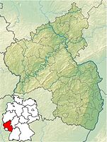
| federal state | Rhineland-Palatinate | |
|---|---|---|
| Residents | 4.336 (2019) | |
| height | 151 m | |
| no tourist info on Wikidata: | ||
| location | ||
| ||
May Chamber is a community in the Front Palatinate, it lies on the edge of the Palatinate Forest.
background
May Chamber is the seat of the association of the same name, which also includes the local communities Kirrweiler and Saint Martin (Palatinate). The place Maikammer lies between Neustadt an der Weinstrasse and Edenkoben below the Kalmit, which at 672 m above sea level is the highest mountain in the Palatinate Forest. The place west of Maikammer became in the 20th century Alsterweiler united with Maikammer.
getting there

By plane
Airports are e.g. the Karlsruhe / Baden-Baden airport![]()
![]()
![]()
![]() (IATA: FKB) 75 km, Stuttgart Airport
(IATA: FKB) 75 km, Stuttgart Airport![]()
![]()
![]()
![]() (IATA: STR) 125 km, airport Frankfurt
(IATA: STR) 125 km, airport Frankfurt![]()
![]()
![]()
![]() (IATA: FRA) 120 km, Strasbourg airport
(IATA: FRA) 120 km, Strasbourg airport![]()
![]()
![]()
![]() (IATA: SXB), Frankfurt-Hahn Airport
(IATA: SXB), Frankfurt-Hahn Airport![]()
![]()
![]()
![]() (IATA: HHN).
(IATA: HHN).


By train
From 1 Maikammer-Kirrweiler station one has connections to Karlsruhe, to Landau in the Palatinate and after Neustadt an der Weinstrasse.
By bus
In the street
- The tourist route German Wine Route leads as L 512South Wine Route through Maikammer.
- The nearest freeway is that
 , the junction
  31 Neustadt is approx. 6 km away.
mobility
Tourist Attractions
- The center of Maikammer is designated as a monument zone.
- 1 Folding meter (on the L512 on the roundabout at the entrance to the village). The folding yardstick was invented by the Ullrich brothers in Maikammer in 1886.
- 2 Cupping monument, Johannes-Damm-Str. 11.
- The 3 Kalmit


 in the Wikidata database") is 672.6 m high. The Kalmithaus and an observation tower are located on the mountain. Nearby is the 620 m high Hüttenberg with the must-see Sea of rocks.
is 672.6 m high. The Kalmithaus and an observation tower are located on the mountain. Nearby is the 620 m high Hüttenberg with the must-see Sea of rocks. - 4 Alsterweiler Chapel, Alsterweiler Hauptstrasse 5, 67487 Maikammer. Tel.: 49 (0)6321 952 781. cath. Chapel, including a remarkable altar from 1445.

activities

shop
- 1 Wine cellar Vinotheque
kitchen
- 1 Ristorante La Corona (Hotel Restaurant La Corona), Weinstrasse Nord 21, 67487 Maikammer. Tel.: 49 (0)6321 5790061, Email: [email protected].
nightlife
accommodation
- 1 Motorhome parking space public, At the Steinmühle 16, 67487 Maikammer.
health
Practical advice
- 1 Maikammer Tourist Office, Weinstrasse Süd 40, 67487 Maikammer. Tel.: 49 (0)6321 952 768.
trips
- There are numerous interesting excursion destinations along the German Wine Route, such as B. that Hambach Castle
literature
Web links
- https://www.maikammer.de/ - Official website of Maikammer