 | WARNING: Due to the outbreak of the infectious disease COVID-19 (see coronavirus pandemic), caused by the virus SARS-CoV-2, also known as coronavirus, there are travel restrictions worldwide. It is therefore of great importance to follow the advice of the official bodies of Belgium and Netherlands to be consulted frequently. These travel restrictions may include travel restrictions, closure of hotels and restaurants, quarantine measures, being allowed to be on the street for no reason and more, and can be implemented with immediate effect. Of course, in your own interest and that of others, you must immediately and strictly follow government instructions. |

| Rupertiweg | ||||||||||||||||||||||||||||||||||||||||||||||||||||||||||||||||||||||||||||||||||||||||||||||||||||||||||||||
|---|---|---|---|---|---|---|---|---|---|---|---|---|---|---|---|---|---|---|---|---|---|---|---|---|---|---|---|---|---|---|---|---|---|---|---|---|---|---|---|---|---|---|---|---|---|---|---|---|---|---|---|---|---|---|---|---|---|---|---|---|---|---|---|---|---|---|---|---|---|---|---|---|---|---|---|---|---|---|---|---|---|---|---|---|---|---|---|---|---|---|---|---|---|---|---|---|---|---|---|---|---|---|---|---|---|---|---|---|---|---|
| ||||||||||||||||||||||||||||||||||||||||||||||||||||||||||||||||||||||||||||||||||||||||||||||||||||||||||||||
Rupertiweg is in Austria.
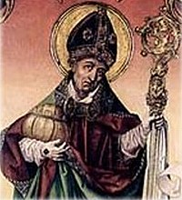
The Rupertiweg, officially the Austrian long-distance route ("Weitwanderweg") 10 starts on the mountain Bärenstein, near the border triangle with Germany and Czech Republic. It runs north-south via Salzburg and Spittal an der Drau to the Italian border south of Hermagor. The usual name is Rupertiweg after the first bishop of Salzburg, Rupert (actually Hruodpert), a Roman Catholic saint who lived around 700.
The route is one of nine hiking trails that traverse all of Austria (number 6 represents a network of shorter routes that all lead to the pilgrimage site). Mariazell lead). All these routes are coordinated by the Sektion Weitwanderer of the Österreichischer Alpenverein (ÖAV) [1]. The section, which is comparable to the Wandelnet in the Netherlands, keeps track of temporary and recent changes in the route on its (German-language) website and annually publishes a guide with maps, route description and elevation graphs, which also contains basic information about catering and public transport. (Sektion Weitwanderer der ÖAV: Osterreichischer Weitwanderweg 10 (Rupertiweg), vom Böhmerwald zu den Karnischen Alpen. No ISBN; the guide can be ordered via the website). The more than 500 kilometers long Rupertiweg is included in its entirety in the European Hiking route E10.
Character
The Rupertiweg runs successively through the Austrian federal states Upper Austria (Upper Austria), Salzburg or Salzburgerland, the German municipalities Berchtesgaden and Schönau am Königsee, again Salzburgerland and finally Carinthia to end up on the Italian border. The route is supposed to have 25 day stages, but that also depends on the personal condition. However, what one can or must do per day is usually determined by the availability of accommodation or public transport.
The Rupertiweg is marked in the field in the usual way in Austria: red-white-red (the colors of the national flag) along all well-maintained paths; white-red-white along paths that experience with mountain hiking require. This entails that at a junction of routes all paths and roads are exuberantly marked in the same way. To distinguish the different routes, road numbers are used (which unfortunately are not always present; a map or guide is indispensable). In order to distinguish the 10 of the Rupertiweg from a possible local hiking route 10 (of which there are many), a number is placed in front of the 10, which is characteristic of the mountain range or the region where you are. Thus Rupertiweg begins as Road 110, then becomes 810, then 410, then 110 again, and so on. It's always the same route!
Safety
Austrians view hiking differently than the Dutch and Flemish. No distinction is made between walking in flat or hilly terrain and mountain walking. There are sections in the Rupertiweg that are too dangerous for hikers without experience with high mountains. Such routes are not indicated in the guidebook and on detailed maps as "gefährlich" (dangerous), but as "schwer" (difficult), "schwierig" (difficult) or "anspruchsvoll" (ambitious). Sometimes it is explained that one must be "schwindelfrei" and "trittsicher", which means that one should not suffer from vertigo (not even from fear of heights) and that one must stand firmly on one's feet - even when one is on a slippery and almost vertical grass or grit slope to move. This is something that one has to learn in the mountains under expert guidance.
Fortunately, such dangerous sections can easily be avoided on the Rupertiweg. The first few hundred kilometers of the route are no more than spicy hilly landscape. Immediately after Salzburg it goes up steeply and long, but this only requires endurance - and good weather. It stays that way (unfortunately good weather is not something one can count on in Salzburg and the Alps!) until past Mallnitz. However, hikers with no mountain experience should not venture into the Reißeck Mountains after Mallnitz; a ride on the Reißeckbahn offers an alternative. From the Reißeckhütte you can then continue safely in good weather.
For the entire route after Salzburg, you should not set out in bad weather. Heavy storms and rain, sudden storms, snow and sleet are all dangers that can take on unprecedented dimensions compared to what you are used to in Dutch-speaking regions. Fog is not only unpleasant, but often leads to hikers getting lost and having to be rescued.
.jpg/200px-Tick_male_size_comparison_(aka).jpg)
Another great danger lurks in an almost invisible small animal: the tick. Ticks can (to varying degrees; in some regions almost 100% of ticks are infected) be carriers of two life-threatening parasites. Ticks live in wooded areas and in tall grass and the like. Lyme disease occurs in the forests along the Rupertiweg, which is spread by tick bites. It is not possible to vaccinate against this disease, but one must check every evening for the presence of ticks. Once infected, a course of antibiotics is necessary. The other tick parasite also occurs in the lower areas along the entire route and causes the disease FSME, a form of meningitis. This disease cannot be controlled with drugs; therefore one should be vaccinated with three injections before the trip. The tick does not occur above an altitude of approximately 2000 meters and there is therefore no risk of infection.
Other hazards along the route are minor; venomous snakes you might step on before you see them pose the greatest risk. Wild boars and other large game are generally shy and hardly live along the Rupertiweg. Rabies (rabies) occurs among forest animals, but is rare.
To the start

Weitwanderweg 10 officially begins at the top of the Bärenstein, a 1077 m high mountain in northwestern Austria. The route descends in two variants to the double city Aigen-Schlägl (600 m), which in practice means that hikers walk up from the station of Aigen-im-Mühlkreis according to one variant and back down via the other. That station has a direct train connection with the city Linz, but in that city one has to take a tram ride from the main station to get to the Urfahr station where the train to Aigen-Schlägl departs. The Austrian Railways website [www.OeBB.at] lists all train connections from stations in Europe and Asian Russia, as well as all Austrian bus connections. Nearby airports are those of Linz, Salzburg and Munich.
Upper Austria (190 or 199 km)
The name "Upper Austria" can be misleading for the Flemish and Dutch: it is certainly not about the highest parts of the state Austria. The landscape can rather be described as a high hill area, just as hilly as the Eifel. The fact that altitudes of more than 1000 m are reached is due to the fact that the whole area is quite high. The "Land" (the German term for a federal state) Upper Austria has largely been cultivated; people usually walk between fields and meadows with scattered groups of trees. Ostermiething is the last place in Upper Austria on the Rupertiweg. The route in Oberösterreich is drawn on maps 262, 432 and 431 of Freytag-Berndt and 202 and 201 of Kompass.
From Aigen-im-Mühlkreis, the Rupertiweg, marked 110, leads via Oberkappel to Niederranna where she crosses the Danube over the only Danube bridge in the area. There used to be a variant (Weg 110A) between Oberkappel and Niederranna, but this has been abolished due to increasing asphalting and traffic. After the Danube crossing, the route, now Road 810, climbs to the village of Mittelbach, where it splits (after 58 km).
The main route continues south as Road 810 to anddorf and pram the ridge Hausruck reach. Now follows a forest walk of several days where there is hardly any opportunity to do shopping or find shelter. Finally one reaches the pilgrimage site Maria Schmolln open country with views to the Alps. Along the city Mattighofen, of which the old center is wrongly not visited, the Rupertiweg continues in a south-westerly direction through the raised moor area ibmer moor from Moosdorf to Ostermiething on the Salzach, where the two variants unite. From Mittelbach it is 132 km to Ostermiething.
The other variant has 141 km and runs as Weg 810A from Mittelbach via Schardenberg near the city Passau nasty Wernstein to the Inn and follows this river upstream. Attractive old towns such as Scharding, Reichersberg and braunau and you get an unexpectedly beautiful view of the German Burghausen. The towns and some castles make up for the fact that the walking route along the river eventually becomes a bit boring. The confluence of Inn and Salzach at Überackern is beautiful, but then there is a long straight to Ostermiething.
Salzburgerland and Berchtesgaden (220 or 230 km)
For the route through the Salzburger Land one can use the maps (1:50,000) 391, 102, 103 and 191 from Freytag-Berndt or the Kompass maps (1:50,000) 291 and 40; Compass map 040 shows the Gasteiner area in more detail (1:25,000). On all these maps the Rupertiweg is marked as Weg 810, 410 or 110, as well as the variant Weg 110A along Bad Hofgastein.

In the State of Salzburg the open hilly landscape initially continues. The route follows the Salzach over the dike along the floodplains to a statue of Saint Nepomuk, which towers high above the river and instills all the more awe at those who clamber up all the stairs with the Rupertiweg. Here Road (8)10 leaves the river for good via Nußdorf am Haunsberg to the Salzburger pilgrimage site of Maria Plain to meander. Here (at an altitude of 530 m) the Rupertiweg splits into two variants that can be easily viewed. To the left, the Gaisberg variant climbs to the much higher peak of the Gaisberg (1288 m). This variant, 26 km long, offers beautiful views in all directions in good weather and avoids the hustle and bustle of the big city. To the right, the 16 km long city variant descends back to the Salzach to cut through the historic city center Salzburg to reach the first high mountains as quickly as possible, or to take a break for a few days in a city with many cultural highlights.
In Salzburg, the marking of Weg 10 changes so that the variants that separated as 810 reunite as 410, at Glanegg, just south of Salzburg. More importantly, the character of the Rupertiweg here changes into an alpine route. Road 10 now ascends, together with a variant of the Voralpenweg (Austrian Road 04, here marked 404A), to the ridge of the Salzburger Hochthron and the Berchtesgadener Hochthron, a steep climb of 1400 meters in elevation. On top, some mountain huts offer meals and lodging. With a steep descent of 1300 meters height difference, the German Berchtesgaden reached, which is overcrowded with tourists in high season. A boat trip over the Königssee (only a few alpine trails can be found on the steep banks) to Sankt-Bartholomä does not immediately bring peace, but the long climb (1500 m uphill) to the Steinernes Meer (no lake, no sea, but a unique lunar landscape of rocks and loose chunks of stone) eventually. After the Riemannhaus (overnight stay possible) it then goes down steeply again (alpine experience desirable; those who suffer from vertigo should avoid this stage) to the fashionable Maria Almo at 800 m altitude.
The Rupertiweg then continues without major problems over the Hundstein (2100 m; overnight stay is possible on top with a magnificent view in good weather) to Taxenbach (hotel) and (now marked as Weg 110) through the spectacular Kizlochklamm (700 m) to the tourist Rauris. After the next climb, to the Seebachscharte (2000 m), you arrive in the gasteiner descend. The Rupertiweg traditionally runs here through the village of Breitenberg and through the vast Bad Hofgastein, but this agglomeration can be avoided by following the alternative Road 110A from the Biberalm (overnight stay possible). At the Angertal station, not far from a few supermarkets, it rejoins Weg 110. The Rupertiweg now ascends gradually through the Angertal along some traditional summer farms where you can spend the night, to over 2200 m and then descends about 650 m to Sportgastein, where the sporting part of the Gasteiner tourism takes place (especially in winter). The Rupertiweg now climbs out of the state of Salzburg past numerous hotels, huts and summer farms.
Carinthia (119 km)

The Rupertiweg enters the federal state Carinthia inside at the Hagener Hütte (2448 m; meals and overnight stay possible) above the mountain tourist village Mallnitz (1191 m), which with a long descent through the valley of the Tauern and along the Jamnighutte (meals and overnight stay possible) is reached. Mallnitz not only has guest houses, hotels and apartments, but also an interesting visitor center of the Natural Park, especially for children Hohe Tauern, the BIOS. Here the marking changes from Highway 110 to Highway 510; the red-white-red paint streaks remain the same. Near the Raiffeisenbank and the bus stop in the center of Mallnitz, the Rupertiweg turns left and after a bridge over a mountain stream, choose a narrow road to the right. After a tunnel under a railway track, the route turns right. Behind the station of Mallnitz-Obervellach (which is not accessible from this side) it takes a narrow path, later a bit of asphalt road, then a gravel road and finally a narrow but easily accessible mountain path up to the Arthur-von-Schmid-Haus and the Reißeck massif. Until it Arthur-von-Schmid-Haus (a mountain hut at 2275 m where you can eat and sleep) the route is easy to do, even in rain. Above the hut, behind the lake is a Blockgletscher, ie a glacier which in winter consists of a mixture of ice and rocks and which slides down slowly (2 cm per year), but in summer, when all the ice has melted, only consists of stones and grit and is still.
After the Arthur-von-Schmid-Haus, the official Rupertiweg not only requires extensive experience with mountain hiking, but also a good condition and exceptionally good weather (you can't go anywhere during a thunderstorm!). The next stage has 9 hours, with no possibility to find shelter in between. You continuously walk above the tree line and rise to an altitude of 2780 m. There is rarely shelter to be found when the weather turns. In addition, the terrain is markedly alpine and often dangerous (steep grit slopes, snow, rocks). If you have no alpine experience, you should go back down here! For whom for the route across the Reißeck massif shy away, fortunately there is an alternative described in the guidebook of Kompass card 49: The Oberkartner Dreischluchtenweg. For this you will first have to walk back to the Dösener Tal and then follow the asphalt road down to Haus Siegelbrunn next to the railway. Just past this guest house, the Driekovenweg starts to the left through the Rabischschlucht to Lassach-Schattseite. The route then crosses the valley to Lassach-Sonnseite and continues through the Groppensteinschlucht to Obervellach (687 m, eating and sleeping possible, bus stop). Just before you reach the village you can view the third gorge, the Raggaschlucht. Then you walk through the picturesque main street of Obervellach, at the end turn left uphill and continue on quiet roads to the ruins of Oberfalkenstein. With a bend you go twice under a railway viaduct, pass under the ruins, and descend to Obergratschach (hotel-restaurants, bus stop). As soon as you reach the main road in Untergratschach, turn sharply left and a little later turn right onto an unmarked field road to the hamlet of Gappen. At the end of the buildings you reach the traffic road again which you now follow for about a kilometer until you can turn left into Penk. This road takes you to Oberkolbnitz (620 m, beds and food in abundance).
Here you can use the Reißeck-Standseilbahn and the Reißeck-Höhenbahn without getting tired up to Hotel Reißeck and the Reisseckhut (eat and sleep at 2287 m). It is of course more sporty to take the local Weg 1 (later Weg 572) along the Zandlacher Hütte (1527 m; overnight stay possible in summer) and go up the two Mooshütten (2380 m); you will then return to the Rupertiweg a little earlier, but have nevertheless avoided the most dangerous part of the Reißeck crossing. But even after the mountain station of the Reißeckbahnen, the Hotel Reißeck and the Reißeckhütte, another difficult scramble along the Hohe Leier follows, so that not everyone will be able to walk along this route. Spittal an der Drau reach. However, it also pays for them to go up, because there is a lot to see: not only grandiose views, but also the impressive technology of a high-altitude reservoir and a railway network that has to contend with snow, ice and avalanche dangers for half a year. .
Just below the ground station of the Reißeckbahnen, an asphalt road leads to the right (to the west). After a junction with a somewhat larger road you can turn left and the Stauseerundweg follow along the Kraftwerk Rottau. immediately after this keep left and at a railway viaduct you reach the hiking trail to and through the Barbarossa Gorge, where an old tradition is revealed. Above the provisional final resting place of Barbarossa, hiking route 7 (sharp right) takes you to Göriach (eating and sleeping to a limited extent in a farm inn that is still furnished as it was a century ago). A paved back road takes you via Stöcklern (keep left) to a footpath through the forest along the wunderblomen. If you then turn right on a paved road, you will pass through the upper village of Lendorf. At the crossroads you go straight ahead and in the lower village you take the tunnel under the busy road straight ahead (here is also catering, and also a frequently operated bus stop). Just after the tunnel, choose a quiet road on the left (walking route 12) that winds its way along the railway and ends as a forest path at the excavations of the Roman city Teurnia (pronounced Teurnia). If you follow the asphalt road to the east and north, after crossing the traffic road in the village of Peter im Holz (restaurants), you will find the marking (510) of the Rupertiweg again. You follow it on a forest path to the right Spittal an der Drau in (shops, restaurants, hotels, youth hostel, bus and train station).
In the thousands of years old city Spittal an der Drau A museum reminds of the distant past, but even more so do the extensive excavations in the area. In addition to the already mentioned Teurnia, there are Museum Carantana with early medieval finds in Molzbichl, the open-air museum [www.Keltenwelt.at Keltenwelt] in Rosegg near Villach and the Fischerei Museum in the village of Seeboden where all the fish of the More from Millstatt swim around.

After crossing the Drau past the Spittal station (560 m), the Rupertiweg ascends as Weg 210 to the top of the mountain Goldeck (2142 m, eating and sleeping in mountain huts, guest houses and a youth hostel). This is followed by a long but gradual descent to the Alm Hinterm Brunn above Neusach on the Weissensee, the lake on which the Elfstedentocht is held when there is insufficient ice in Friesland. Around the lake are numerous villages that [www.Weissensee.com] offer shelter. After the alm, the Rupertiweg makes a big detour to Techendorf, which forms an elongated village with Neusach. The Rupertiweg crosses the Weissensee (934 m) with a bridge and leads via the Naggler Nock (1324 m) to Sankt-Lorenzen-im-Gitschtal and Hermagor (602 yards). Hermagor is, partly due to its popularity among Italian tourists, an expensive center for tourism; You can stay cheaply in neighboring Postran. The route runs all the way through the elongated village, passing the train and bus station.
After crossing the railway track, the Rupertiweg (now marked as road 410) turns straight south, crosses the river Gail with a bridge and after a few hundred meters chooses a forest road to the right. After a few sharp bends, a forest path is turned to the right, which reaches another forest road at an altitude of more than 1200 m. It follows the Rupertiweg to the right and at a crossroads straight ahead but bends to the left, while it continues to climb. At 1480 m altitude, the Kuhweger Alm offers food and drink, but no overnight stays. For that you have to ascend further to the Kuhweger Törl (1914 m) and descend slowly to the Watschiger Alm and the Naßfeld on the Italian border (1530 m). This border pass is the end of the Rupertiweg. Restaurants in all price ranges can be found in the area.
The Carinthian section of the Rupertiweg is drawn on Freytag-Berndt's maps 225, 221 and 223 and on Kompass maps 49 and 60.
After the end point
From the Naßfeld you can get away in two ways (unless you are going on a hiking route along the border or in Italy): by cable car or on foot. For the cable car you will have to follow the Austrian Weitwanderweg 403 to the west. Walking back is best if you choose the route through the Garnitzenklamm to Hermagor (when it rains, the climbing path in this gorge becomes very slippery). In Hermagor you can take the train to Villach to take; for connections to any station in Europe and Asian Russia, please consult [2]. The Austrian Railways also provide a fast bus connection with Venice, which has an international airport.
| This is a guide article . It contains a large amount of good, quality information about relevant attractions, entertainment venues and hotels. Dive in and make it a star article! |
| This article incorporates information from the Rupertiweg article on Wikipedia. See the page history there for the list of authors. |