 | WARNING: Due to the outbreak of the infectious disease COVID-19 (see coronavirus pandemic), caused by the virus SARS-CoV-2, also known as coronavirus, there are travel restrictions worldwide. It is therefore of great importance to follow the advice of the official bodies of Belgium and Netherlands to be consulted frequently. These travel restrictions may include travel restrictions, closure of hotels and restaurants, quarantine measures, being allowed to be on the street for no reason and more, and can be implemented with immediate effect. Of course, in your own interest and that of others, you must immediately and strictly follow government instructions. |

The European walking route E10 runs from the northernmost tip of Finland through eastern Germany, the Czech Republic and Austria to the Italian city Bolzano (Bozen). The E10 does not pass through the Netherlands and Belgium. The closest is the route in Germany, where they Potsdam the one coming from the Netherlands E11 crosses. European walking routes such as the E10 are coordinated by the European Walking Association (EWV), in which the Stichting Wandelplatform-LAW is represented from the Netherlands. The actual development and maintenance of the E-routes is the responsibility of the affiliated national and regional hiking organizations.
The E10 is made up of several long-distance routes at national level. These are successively in Finland the UKK path (named after the former Finnish president Urho Kaleva Kekkonen), in Germany the former A-Z-Road (which in DDR times Cape Arkona of Zittau covenant), and in Austria the Rupertiweg. Furthermore, the E10 uses parts of other national and regional paths, such as a route along the Vltava in the Czech Republic (between Prague and Ceske Budejovice and in Austria parts of the Nordwaldkammweg and the Südalpenweg.
From long-standing plans to extend the E10 to the south of Spain,[1] almost nothing came of it.[2] Named Gorges[3] already in 1999/2000 the Tratto Lombardo and the Grande Traversata delli Alpi in Italy and the French GR 52A and Gr 51 as a possible continuation of the E10, his influence as then president of the European Hiking Association was not allowed to lead to the relevant national organizations decided to do so. In Spain a piece of the GR92 was already finished, namely from the French border to Ulldecona, but this is also partly used by the E4 and about 2000 kilometers were still missing.
In Finland too, the route is largely still in preparation, while communication about the exact course, marking and the extent to which facilities for eating and sleeping can be found is very unclear.[4] The emphasis is therefore on the part of rugen to Bolzano, which is now fully drawn on maps and as a rule also well marked in the field.
Info
| E10 | |||||||||||||||||||||||||||||||||||||||||||||||||||||||||||||||||||||||||||||||||||||||||||||||||||||||||||||||||||||||||||||||||||||||||||||||||||||||||||||||||||||||||||||||||||||||||||||
|---|---|---|---|---|---|---|---|---|---|---|---|---|---|---|---|---|---|---|---|---|---|---|---|---|---|---|---|---|---|---|---|---|---|---|---|---|---|---|---|---|---|---|---|---|---|---|---|---|---|---|---|---|---|---|---|---|---|---|---|---|---|---|---|---|---|---|---|---|---|---|---|---|---|---|---|---|---|---|---|---|---|---|---|---|---|---|---|---|---|---|---|---|---|---|---|---|---|---|---|---|---|---|---|---|---|---|---|---|---|---|---|---|---|---|---|---|---|---|---|---|---|---|---|---|---|---|---|---|---|---|---|---|---|---|---|---|---|---|---|---|---|---|---|---|---|---|---|---|---|---|---|---|---|---|---|---|---|---|---|---|---|---|---|---|---|---|---|---|---|---|---|---|---|---|---|---|---|---|---|---|---|---|---|---|---|---|---|---|---|
| |||||||||||||||||||||||||||||||||||||||||||||||||||||||||||||||||||||||||||||||||||||||||||||||||||||||||||||||||||||||||||||||||||||||||||||||||||||||||||||||||||||||||||||||||||||||||||||
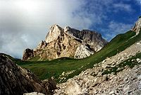
The E10 offers a cross-section of Europe in a north-south direction, passing through some extreme European landscapes, especially the treeless tundra in the north of Lapland, the Finnish primeval forests near Kuusamo, the skerries landscape in the Baltic Sea, the Reißeck-massive in the austrian Alps and the even more unapproachable Dolomites on the border of Austria and Italy. In between, there are much friendlier landscapes that are easier to walk on: the lake districts of Finland and eastern Germany, the chalk cliffs and rapeseed fields of ruegen, the hills of southern Finland and northern Austria, and the low mountain ranges of Czech Republic. Also the sun-drenched southern flank of the Alps in Italy can be controlled without too much effort. In addition to exceptional landscapes, the E10 also offers an unusually rich range of regions that have endured more than average the political consequences of the two world wars of the last century. In Finnish Lapland, for example, no building was left standing when the Finns had expelled the Germans. The area along Finland's eastern border witnessed two wars with the Soviet Union in the 1940s. From Rügen to the Czech border, the E10 passes through areas belonging to the former DDR were cut off from the rest of Germany.
On entering the Czech Republic and again on leaving it, mountains (mostly mining areas) are crossed that were annexed to the Czech Republic after the First World War, but had a majority Austrian, so German-speaking population. After the Second World War, this still German-speaking population group was expelled from the Czech Republic; it now forms the core of the "Heimatvertriebene" (less properly called Sudeten Germans). Today, the Czech Republic is a homogeneous Czech-speaking country. In various museums along the E10 you can view the fate of the Czech-speaking population before and during the annexation to Hitler Germany. On both sides of the Czech-Austrian border, museums and road monuments focus on the German speakers who subsequently had to leave the Czech Republic.
The province has a more or less similar history South Tyrol (Südtirol/Alto Adige), which reaches the E10 from Austria. Until the end of the First World War, this predominantly German-speaking area was part of Austria, but was then added to Italy. Remarkable is that Adolf Hitler refused it at his Third Reich (Dritte Reich) because he is his ally Benito Mussolini wanted to be a friend. About two thirds of the population of South Tyrol still speak German as their mother tongue. Only in the capital Bolzano has Italian become the language of the majority.
To prepare
Safety
.jpg/100px-Tick_male_size_comparison_(aka).jpg)
Parts of the E10 are a very safe walking route, while other parts should be described as dangerous. The greatest danger posed by solitary and mountainous areas, such as in FinnishLapland and the Alps. In Lapland and other northern Finland you need to be in excellent condition, bring food for a few days (water is available in nature), and also a bivouac bag or small tent and sleeping bag. A number of Alpine routes are reserved for experienced mountain hikers; Don't venture into terrain if you're not sure you can handle it!
Another great danger lurks in an almost invisible small animal: the tick. Ticks can (to varying degrees; in some regions almost 100% of ticks are infected) be carriers of two life-threatening parasites. Lyme disease, which is spread by tick bites, occurs throughout the E10 region. It is not possible to vaccinate against this disease, but one must check every evening for the presence of ticks. Once infected, a course of antibiotics is necessary. The other tick parasite occurs in the forests along the entire route and causes the disease FSME, a form of meningitis. This disease cannot be controlled with drugs; therefore one should be vaccinated with three injections before the trip.
Other dangers along the route are minor: wild boars and other large game are generally shy and hardly live along the coast. Rabies (rabies) occurs among forest animals, but is rare.
To the start
The official start of the E10 is in Nuorgam, the northernmost tip of Finland. There is already a walking route to the Southeast, with a temporary end in Sevettijärvi, not far from it three-country point of Russia. The route is marked to the extent that it runs for a large part along the Finnish-Norwegian border, so that the boundary stones indicate where the E10 runs. The route is described impressionistically in a German text on the above-mentioned Finnish website, but it remains unclear why the author had to walk for 6 days over a distance indicated as 80 km, and then accepted a lift for the last 20 km.[5] In 1997 this stretch was marked with red paint on trees and stones,[6] but it seems to have completely disappeared in 2006.
More to the south, some parts of the E10 are already well marked and provided with sufficient opportunities to spend the night. This includes the well-known Karhunkierros (Bear Round) that can be walked in about 5 days. A detailed description in German is available for this, which also proves its usefulness during a trip in winter or by canoe.[7] For those who are not sufficiently proficient in German, a detailed map richly provided with useful symbols is available for sale.[8]
In the future, the E10 will leave Finland in the port city Hanko/Hangö in the extreme southwest of the country. Until recently, it was obvious for passing walkers to travel with a ship of the Danish-German scanlines to the German port city Rostock and from there by train and bus to Hood Arkona on ruegen, where the E10 officially continues. However, this travel option is no longer mentioned in the Scandlines timetable, so that there is no other option than to make a laborious detour via Sweden or the Baltic States.[9]
Actually, it makes sense to skip the Finnish part completely until it is well developed. The start is then on Hood Arkona, the northernmost point of the German Baltic Sea-Island ruegen. The [www.Bahn.com Deutsche Bahn] website makes it easy to find out how to get there. A few kilometers away are some guest houses and hotels.
Route
Germany
The E10 runs through Germany twice. A little piece in the Berchtesgadener Land is described further on in Austria. The lion's share of the German E10 is located in the former German Democratic Republic (East Germany) and extends from the northern tip of the Baltic Sea island ruegen to the border of Germany and the Czech Republic. In the federal states Mecklenburg-Western Pomerania and Brandenburg the E10 is almost identical to the former DDR Hauptwanderweg A-Z-Road, but in the state Saxony significant changes have been made in the process.
- Ruegen.
- Mecklenburg-Vorpommern.
- Europäischen Fernwanderwegen E10 in Brandenburg and Berlin, running from Strasen nasty Bad Muskau[10][11]. (Note: Between Spremberg and Bad Muskau there is an overlap of (31.5 km) with the next part) (depending on variant 298-320 km)
- Europäischer Fernwanderweg E10 in Saxony, running from Spremberg nasty Seifhennersdorf and the Czech Varnsdorf (160km).
Czech Republic
- From the German-Czech border at Varnsdorf the E10 runs via Ceska Lipa nasty Prague.
- Then he follows the river for a long time Vltava through beautiful landscape to which smetana's famous composition does full justice (in fact one should walk this stretch from South to North).

After Ceske Budejovice the E10 is indicated on map 2024 (2082) of Kompass. The route climbs to the top of the shit' (1083 m) and then descends steeply to the scenic Cesky Krumlov. This medieval town presents itself as a cultural center with a festival around the longest day of the year, but is especially an attraction for young backpackers, who should not think of walking but walking. The place is teeming with cheap hostels and alternative restaurants, which allow for a closer look at the centuries-old houses.
From Český Krumlov, the E10 can also be found on map 262 of Freytag & Berndt. It runs marked blue to Světlik and then marked green to the reservoir in the upper reaches of the Vltava. This region is so popular with Dutch tourists that the prices of an overnight stay in the summer reach fabulous heights: sleeping in a furnished bungalow tent with Dutch management costs five to ten times as much as a cheap guest house elsewhere in the Czech Republic. Meanwhile, the blue marking guides the E10 hiker over Frymburk and Lipno nad Vltavou nasty Vyssi Brod, which then reaches Studánky on a busy road, and shortly afterwards the Austrian border (between Vyšší Brod and the border the route is not on the map and after Studánky it is not marked either).
At the station of Lipno nad Vltavou a blue marked variant starts, which runs over the Medvědi hora to the Austrian border and follows it for about 3 km to the west, to Guglwald (see below). The route actually runs on a path completely overgrown by high nettles, but if you follow the adjacent asphalt road, you pass some monuments that remind of villages that were here until 1945. After 1945 there was a military barrier area along the border, equipped with live steel wire, a strip of land mines, watchtowers and a road where the border police patrolled. Only the road remains. This variant arrives at Guglwald on Austrian territory (see below).
Austria (661 to 711 km)
In Austria, the E10 is initially not marked as such; from the border crossing at Weigetschlag he follows the local Road 11 to the village of Rading, then local Road 12 until Bad Leonfelden. From here the E10 is identical with part of the Nordwaldkammweg,[12] which is included in its entirety in the E6.[13] The E10[14] now runs in a (north) west direction to Guglwald, where it unites with the above variant from Lipno nad Vltavou at a hotel-restaurant built as a castle, which dedicates a permanent exhibition to the German-speaking population expelled from the neighboring Czech municipalities in 1945 . The E10 follows the Nordwaldkammweg and the E6 over Haslach and Sankt Oswald bei Haslach to the Bärenstein mountain above the twin town Aigen-schlägl. The distance from the border at Weigetschlag to Guglwald is 20 km; from Guglwald to the Panyhaus on the Bärenstein 29 km.
Rupertiweg

In schlägl begins the Austrian hiking route 10, the Rupertiweg,[15] with a loop to the Bärenstein and back to schlägl. This national route is an integral part of the E10 and ends in Naßfeld on the Italian border. If you follow the E10, you can therefore choose on the Bärenstein between an easier, partly asphalted eastern descent over Panyhaus and a more westerly, more beautiful descent along the Liebesfelsen; both routes come together Aigen. Depending on the variants chosen, the Rupertiweg is 529 to 548 km long. A more detailed description of this part of the E10 can be found under Rupertiweg.
The E10/Rupertiweg crosses the a little further south E8; between the Ameisberg and Oberkappel they walk together. After crossing the Danube the walker has the choice of two variants: an easier but more boring route that mainly follows the banks of the rivers Inn and salzach follows and a more varied, hillier track over, among other things, the Hausruck. In Ostermiething the two variants come together for a common route to the city Salzburg. Here the hiker chooses again: There is a beautiful but difficult route over the Gaisberg, but you can also walk through the middle of the city. In the city and on the Gaisberg, variants of the E4 crossed; here and there the E10 and the E4 run together.

Immediately after the district of Glanegg, the Alps rise high above the hiker. Here the E10 begins an alpine rise of more than 1000 meters in elevation. From this point to the end point in Bolzano, the hiking trail is a high mountain route that is too difficult in some parts and therefore too dangerous for inexperienced mountain hikers. This already applies in rainy weather (smooth grass slopes and rocks) for the first mountains: the Salzburger and Berchtesgadener Hochthron. In good weather, the view over the Alps and large parts of Bavaria and Austria is of course phenomenal.
Besides being dangerous due to slippery and steep slopes, the E10 in the Alps is also a battle of attrition. This is because the mountain ranges are crossed transversely. Again and again it goes up a thousand or more meters and a little later it goes down again. Anyone who wants to walk this route must therefore have good stamina.
The first descent goes to the German Berchtesgaden. A boat trip on the Konigssee takes the walker to the foot of the Steinernes Meer, not a water surface but a stone wasteland for which you first have to rise more than 1000 meters. Further striking points on the route are the touristic Maria Almo, the sober Taxenbach and the fashionable spa badgastein, always separated by high mountain ridges.
In Mallnitz becomes the state Carinthia reaches. Most hikers should be discouraged from crossing the Reißeckgruppe to venture, because this requires thorough experience with mountain hiking and then the weather conditions usually do not cooperate. Fortunately, there is an equally beautiful alternative via Obervellach; from Kolbnitz the mountain Reißeck is easier to climb.
Südalpenweg
From Naßfeld, the E10 westwards follows the mountain range of the Carinthian Alps, which forms the state border between Austria and Italy. More precisely, the E10 here is equal to the Austrian hiking route 3, the Südalpenweg (local marking 403; variants 403A), which again usually corresponds to the Karnischer Höhenweg and a branch of the Via Alpina. The E10 has a pronounced alpine character here. There is also an indispensable guidebook for this "Weitwanderweg".[16] The guide is updated and published annually and, in addition to a detailed route description, contains information about how dangerous the route is here and there, as well as where to eat and sleep. For shopping you will have to descend 1000 meters or more to a valley on the Austrian or Italian side, but food and drink are available in the huts.
Experienced mountain hikers can easily follow the main route in 3 or 4 days to the Austrian Hochweißsteinhaus below the Italian summit of the Monte Peralba come (there are high-alpine variants). From here, most mountain hikers prefer more dangerous, but interesting and shorter routes on Austrian territory, but the main route through Italian territory allows even in bad weather or limited mountain experience the Porzehut reach. For whom the passages over the Roßkopftörl and the peaks of Eisenreich (2665m), Schöntalhöhe (2635m), Demut (2592m), Hollbrucker Spitze (2580m), Hornischegg (2550 m) and Hochgruben (2538 m) finds too dangerous or strenuous, a descent on Road 465 presents itself as an alternative; one then enters the village Kartitsch out and will the next day through the valley to Sillian walk.
Bee Sillian the E10 bids farewell to Weg 03 and Austria. The confluence with Weg 03 is, depending on the variants chosen, 109 or 114 km long. The trajectory of Hermagor (the traffic junction below Naßfeld) to Sillian can be completed in about a week. It is necessary to take into account daily stages of 7 hours or more, to which the rest breaks still have to be added. The route can be found on maps 223 and 182 of Freytag-Berndt or 60 and 47 of Kompass.
Italy (132km)
In Italy, the E10 does not follow an existing regional or national walking route, but switches to a different local route every few kilometers. Also, the marking of the E10 as such is very flawed. The local routes are well marked, namely with the same system that is also used in Austria. This makes it possible to find the E10 using the list below of the places and routes to visit. This is based on the no longer available overview of Gorges[3] and recent Kompass detailed maps.[17] Also useful are the maps S3 (to Bruneck), S16 (Bruneck - Brixen) and S1 (Brixen - Bolzano) by Freytag & Berndt. Although in Italy people still walk in the Alps, the route is a lot easier and less dangerous than the Austrian part. However, the migrating hiker should take into account that it is difficult to find shelter in August; it is then overcrowded in the Dolomites.

From the Austrian border, the E10 follows a walking route north of the Drau (Drava) to Winnebach (Prato alla Drava). Then it goes via Road 14 to the chapel of San Silvestro, then straight on Road 1A to the Silvesteralm, there to the left, follow the Toblacher Höhenweg (Road 1) through the valley of the Silvesterbach to the fork at the bus stop below the village of Kandellen. Follow the paved road down past the Gentian hut to the village of Wahlen (Valle San Silvestro; here is the Silvesterhütte) above toblach (Dobbiaco).
In Wahlen turn right on Route 41 to the Kirchberg, Schloß Welsberg and the village welsberg (Monguelfo-Tesido). Here the E10 crosses the Gsieser Bach (Rio di Casies) and follows the paved road for 2 km to Taisten (Road 38). Take a sharp left here onto Weg 21 over a paved road, after approximately 5 km dirt road follow to Niederrasen. On the other side of the valley of the Antholzer Bach (Rio Anterselva) choose the E10 Route 4 and later Route 17 or 17A to the Erdpyramids (Piramidi di Terra), pointed clay points with sometimes a boulder on top, a surrealistic face. There is a sign here that indicates that the E10 really runs here.
From the earth pyramids, the Pyramidenweg runs to the Pyramidencafé, which is connected to . by Road 1 Bruneck (Brunico); it is unclear whether this is the route over the non-existent "Oberwielbach" indicated by Gorges. In any case, the E10 continues from the Stegen district along Weg 7 to Palatinate (Falzes) and Issing (Issengo). Here it goes diagonally left with Weg 5 to the Issinger Weiher (Lago d'Issengo). Now turn right to Mühlen and on Route 3 via Hofern (Corti), Moar am Gruben, Ast and Terento (Terento). In Terento, Road 9/9A is the most direct route to Niedervintl (Vandoies di Sotto).
From Vintl, the E10 is indicated on the Kompass maps. He crosses the river Rienz (Rienza) and then follows Road 3 (another Road 3 than at Terenten) to Rodeneck (Rodengo). Then about 1 km with Road 2 to Vill and a long pull on Road 1 to brixen (Italian name: Bressanone, Ladin name: Porsenù). This city on the railway line to Innsbruck and Munich and at the confluence of Eisack (Isarco) and Rienz(a) is the first major city to stop and cross the route in Italy. After Brixen, the E10 climbs one more time, via Weg 8, to above 2000 meters, to take in the distant views from the Radlseehutte and the Jocherer Berg (Monte del Passo) on Route 1, from Pemmern Weg 6, descending to the deep Bolzano. The city has 3 names, because 3 languages are spoken. Bolzano is the Italian name used by three quarters of the population, Bozen the German name of the original language majority and Bulsan the name that refers to the minimal Ladin language minority.
footnotes and references
- ↑ Freytag & Berndt commissioned by the European Hiking Association: European Footpaths (2001), map and route description. ISBN 3-7079-0100-9
- ↑ Prames commissioned by the European Hiking Association: Map of European Long-Distance Footpaths (2011). ISBN 9-788483-21962-1
- ↑ 3,03,1 Hans Jürgen Gorges: Auf Tour in Europe. The Handbook for the Europäischen Fernwanderwege. ed. Compass, 1999/2000. ISBN 3-8134-0338-6
- ↑Template:Fi (the) (and) www.SaunaLahti.Fi/EeroMari/
- ↑see Hartwig at www.SaunaLahti.fi/EeroMari/, click through to "Auf Schusters Rappen", "E10 - von Nuorgam ... nach Hanko" and "Volker Hartwigs Trekkingseiten"
- ↑Jaap Pegels: Finland. 35 day routes and 4 long-distance walks. Elmar Hiking Guide, 1997. ISBN 90-389-0479-7
- ↑ Michael Hennemann, "Finnland: Bärenrunde", ed. Stein Verlag in the series "Outdoor, der Weg ist das Ziel". ISBN 978-3-86686-085-8 .
- ↑ Ulkoilukartat, "Rukatunturi Oulanka, Karhunkierros", ISBN 978-951-59-3728-5 . Topographic map 1:50 000 on which the Karhunkierros is drawn.
- ↑www.Scandlines.de
- ↑Wanderungen durch Brandenburg, Unterwegs auf den Europäichen Fernwanderwegen, Trescher Verlag. Description of E10 and E11 in the state of Brandenburg (2003). ISBN 3-89794-033-7 (the)
- ↑Compass Wander- und Radtourenkarte (1:50,000) No. 745 Havelland. ISBN 3-85491-505-5 with signed E10 between Paaren im Glien, via Potsdam to Stucken.
- ↑Margot Haag: Nordwaldkammweg, Wanderbegleiter. Edition Ennsthaler. ISBN 3-85068-603-5
- ↑{de} see the entry "Nordwaldkammweg" in the German version of Wikipedia.
- ↑on map 262 of Freytag-Berndt and Kompass map 2024=2082 and in the field only the E6 and the Nordwaldkammweg are indicated, the latter with a logo in white and blue
- ↑Erika & Fritz Käfer, Österreichischer Weitwanderweg 10 (Rupertiweg), ed. Oesterreichischer Alpenverein, Vienna. No ISBN, available at www.OeAV.at/Weitwanderer/index.php
- ↑Fritz and Erika Käfer, Günther Eigenthaler: Österreichischer Weitwanderweg 03 (Südalpenweg). ed. OeAV, no ISBN. To be ordered at Weitwanderer@@Sektion.Alpenverein.at.
- ↑Kompass card 699, South Tyrol Alto Adige
external links
| This is a usable article. It contains information on how to get there, as well as the main attractions, nightlife and hotels. An adventurous person could use this article, but dive in and expand it! |