 | WARNING: Due to the outbreak of the contagious disease COVID-19 (see coronavirus pandemic), caused by the virus SARS-CoV-2, also known as coronavirus, there are travel restrictions worldwide. It is therefore of great importance to follow the advice of the official bodies of Belgium and Netherlands to be consulted frequently. These travel restrictions may include travel restrictions, closure of hotels and restaurants, quarantine measures, being allowed to be on the street for no reason and more, and can be implemented with immediate effect. Of course, in your own interest and that of others, you must immediately and strictly follow government instructions. |

| This article incorporates information from the Wikipedia entry Hiking Route E9. See the page history there for the list of authors. |
The Hiking route E9 lies in Europe
Overview
The European Hiking Route E9 is one of eleven long-distance trails coordinated by the European Hiking Association and maintained by national or regional hiking organizations. The E9 runs along the coast of Portugal, Spain, France (with a variant along the English south coast), Belgium, Netherlands, Germany, Poland, Russia (Kaliningrad), Lithuania and Latvia nasty Estonia. Parts of the route, especially in Portugal, France and the Baltic areas, are not yet fixed or are not yet marked. The route, if marked, is approximately 8000 km long. In principle, the route is defined from Portugal in the direction of Estonia, but there is no objection to going the other way. For the route between Santiago de Compostela and Royan near Rochefort, this is even the most common direction.
The E9 offers a varied view of the coasts of Europe. Sandy coasts with dunes and low hinterland or polders predominate in Portugal, southwestern France, Belgium, the west coast of the Netherlands and the coast of the Baltic Sea in Germany, Poland and the Baltic region. In northern Spain, on the other hand, high mountains rise steeply from the Atlantic Ocean. The shores of Brittany and Normandy in France and the English south coast are characterized by chalk and other rocks, cliffs and intimate beaches on small bays. The north coast of the Netherlands and west Germany is a Wadden coast with a brackish lagoon and adjacent polder land. Fjords, as they are in Norway and Scotland finds, however, are completely missing, as are - and this is surprising - islands off the coast (with the exception of the islands in the Dutch province Zealand). Fjords are widely available along the North Sea path, http://www.northseatrail.nl/planner/europa.asp, which in the Netherlands coincides with the E9.
Safety
.jpg/220px-Tick_male_size_comparison_(aka).jpg)
The E9 is a very safe walking route. The greatest danger lies in an almost invisible small animal: the tick. Ticks can (to varying degrees; in some regions almost 100% of ticks are infected) be carriers of two life-threatening parasites. Lyme disease, which is spread by tick bites, occurs throughout the E9 region. It is not possible to vaccinate against this disease, but one must check every evening for the presence of ticks. Once infected, a course of antibiotics is necessary. The other tick parasite occurs from Lübeck to the Baltic States and causes the disease FSME, a form of meningitis. This disease cannot be controlled with drugs; therefore one should be vaccinated with three injections before the trip.
In extreme weather conditions, such as sleet, severe storms and danger of spring tides and flooding, the coastal route in general, and parts directly exposed to the sea in particular, should be avoided. Only the Baltic Sea lends itself to sea swimming; the coastal waters of the Atlantic Ocean, the Channel and the North Sea have strong currents that can drag you far out to sea; and the Wadden Sea is shallow and muddy. Other dangers along the route are minor: wild boars and other large game are generally shy and hardly live along the coast. Rabies (rabies) occurs among forest animals, but is rare. In some nature reserves you could step on a poisonous viper; watch where you put your feet. Those who are in some shape will find a place to sleep after a maximum of 25 km (wild camping is possible almost everywhere). Because the route almost always follows the sea, getting lost is virtually impossible. There are no indications of high crime along the E9, with the exception of some areas in the major port cities and areas near ferries to England where underprivileged refugees gather for an illegal crossing.
To the start

The E9 starts at Cabo de São Vicente (Cape Saint Vincent), the extreme southwest point of the European mainland in Portugal's favorite holiday region Algarve. The place is accessible from the village Sagres which is surrounded by a number of similar capes. At 37° 1' 30" N latitude, this is also the southernmost point of the European coastal route, which runs mainly northwards. The cape should also be one of the starting points of the E4 become, which are still in Gibraltar Start.
However, it is not obvious to start at Cape Saint Vincent, because the first 200 km are not marked or described. It's better in the city Lisbon to start, because it is easily accessible by plane, train and car, and even across the European walking route E7. Because only a few individual day routes have been set out in that area, it is best to move into Lisbon for a week, familiarize yourself with the public transport in the area and take the routes below as day trips. That will not work with the long march through the Rede Natura do Oeste, because there are no facilities and connections there. Illegal camp there seems to be the only possible solution if you don't have an iron condition. After walking all the pieces of E9 around Lisbon, take the train to Porto to start the actual hike. You can find the timetable here.
Of course it is possible to walk the E9 in parts. Then choose the large cities as entry and exit stops, because they have good train connections (see [1]) and often an airport as well. The cities that lend themselves to this are included in the overview figure at the top right of this article. Between the Polish braniewo and Tallinn in Estonia you will have to get off the route anyway, because it is not defined there. The E9 in Estonia consists of separate sections. If you want to walk the rest of the route in the opposite direction, you can braniewo to start; the city is accessible by train [2].
The E9 in Portugal (400 km)

The E9 runs parallel to the Atlantic coast throughout Portugal and is also known in the country as the Caminho do Atlântico. From the part south of Lisbon only a few small routes are marked and maps are not always available. For example, 87 km have been plotted from Santiago do Cacém (38º 01' North latitude) to Alcácer do Sal (38° 21' North latitude) via San Bartolomé da Serra, Santa Margarita da Serra, Grândola, Vale de Guizo and Barrosinha [3]. Another 60 km walk from Sesimbra (38° 26' N latitude) via Cabo Espichel, Aldeia de Mec, Apostiça, Fonte da Telha, Sobreda and Caparica to Porto Brandäo near Lisbon [4]. In the agglomeration of Lisbon (38° 43' North latitude), where the E7 crosses the E9, are 24 km from Azóia via Magoito to Odrinhas[5]. Bee Sintra (west of Lisbon) are touted another 27 km [6] and [7]. In the Rede Natura do Oeste one can walk from Praia da Assenta (39° 03' North latitude) to Cabo Carvoeiro in Peniche (39° 19' N), a distance of 70 km with no facilities for eating and sleeping [8]. According to Traildino, the entire route north of Lisbon, which runs via Porto, would be ready [9]. Both sources agree that the GR 11 follows the same route as the much older one James Way nasty Santiago de Compostela, the Caminho de Santiago or (in Galician) Camino Portugues.

It will be clear that for these escapades you need an adventurous spirit, a strong physical and mental condition and a lot of travel experience. If you prefer to take it a little easier, start right away postage.
The Way of Saint James runs from the city of Porto Caminho Portugues over Barcelos, Ponte de Lima and Valença to Tui on the border with Spain. The route from Porto to Santiago de Compostela is described in detail in German in Raimund Joos: "Portugal Spanien: Jakobsweg Caminho Português", ed. Conrad Stein Verlag; ISBN 978-3-86686-383-5 . Of these, according to the Portuguese mountain hiking club Federação Portuguesa de Montanhismo e Escalada FPME, 50 km are in the municipality Barcelona marked, namely from Courel via Furada, Pereira, the village of Barcelos, Neiva, Vila Boa and Aborim to Balugães [10].
The E9 in Spain (982 km)
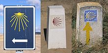
There are many misunderstandings about the Spanish part of the E9. Most importantly, the E9 would have yet to be designed here, not yet described and not marked yet. The reality is the other way around: the Spanish tracee has been in use for more than a century and there are numerous publications devoted to it. One should only know that the E9 in Spain coincides with some St James' Way. This may mean that the routes are only marked to Santiago. Moreover, the marking is not the usual white-red stripes, but the yellow scallop on a blue background.
From the border town tui the E9 continues on Spanish territory under the Castilian ("Spanish") name Camino Portugués. In here Galicia Galego is also an official language, so this Way of Saint James is also called Camiño Portugués here. Through redondela, Pontevedra and padron he reaches the pilgrim city Santiago de Compostela. The distance from Tui to Santiago is 107 km, detailed in the article about the Caminho Portugues.
Leaving the E9 Santiago de Compostela about a James Way known as the (Spanish) Coastal Route, the Camino de Santiago de la Costa. He runs to Arzua together with the European Hiking route E3 over the Jacobsweg Camino Frances, but then turns left onto the Spanish North Coast to through Santander, San Sebastian and BilbaoIrun reach. Here the E9 crosses the French border to Hendaye. This 875 km long coastal route is in the German extensively described in an e-book by Raimund Joos: "Spanien: Jakobsweg Küstenweg" (eBook), ed. Conrad Stein Verlag, ISBN 978-3-86920-071-2 ; to order via [11].
The E9 in France


When walking major route paths (long-distance hiking trails) in France, you basically use four sources:
- The topo-guides of the FFRP, the Fédération Française de la Randonnée Pedestre. These walking guides provide detailed route descriptions in French, but thanks to detailed maps and the use of symbols, they are also useful for those who do not speak French. They can be ordered through the FFRP website [12] and are also sold in Dutch stores such as Bever Zwerfsport and specialized bookstores.
- The topographical maps of the Institut Geografique National (find out via the website [13], but for sale in small villages);
- The GR-infos website [14] with a projection of the route on the Google map with associated addresses where you can sleep on or near the route.
Topo-guides do not exist for all GRs, or for all sub-sections thereof, and a few sections have not yet been worked out for GR-infos, but the IGN maps are generally complete. All GRs are marked with the white-red stripes familiar from Dutch LAWs.
- The Géoportail website with digital map on which almost all GR trails have been drawn. This is the most complete resource, but it takes a lot of effort to find the information you need, as it's often only at a few zoom levels.
Aquitaine (400 km)

Just after the Spanish-French border, in the city and seaside resort Hendaye in the department Pyrenees-Atlantiques, begins the Pyreneeshiking trail GR10. The E9 follows it for approximately 21 km to the village saree. Topoguide 1086 of the FFRP describes the route in detail. You will also find details on the Gr-infos website [15]. In Sare you can spend the night in a hotel and various chambres d'hôtes. In Sare, the E9 takes the hiking trail GR8 up, to follow it north through the departments Landes and Gironde to the mouth of the Garonne, also called Gironde. The GR 8 is described in detail in Wikivoyage, albeit from north to south. The first two days (about 50 km), until Urt near Bayonne, are also described in Topoguide 1086; after that you have to rely on IGN maps and the Géoportail while walking. During the preparation you can here find addresses where you can sleep.

.JPG/220px-Pointe_de_Grave_(Royan_en_face).JPG)
The GR 8 is defined to labenne; after that you can do the best for the time being Voie Littorale follow until Arcachon. You then have to sail to Le-Cap-Ferret, follow the GR 8 marking to Contaut, then follow the Voie Littorale again to Le-Verdon-sur-Mer, where the ferry will take you to Royan. From Urt it is approximately 325 km to Le-Verdon-sur-Mer. Because the route always follows or close behind the sandy beaches and dunes of Les Landes runs, there is plenty of accommodation in the summer, including campsites. However, in the middle of winter you will often find yourself in front of a closed door, unless you make a reservation via the internet, by email or by telephone (foreign languages are increasingly spoken in France; try English, sometimes German if necessary). As a rule, it will not be difficult to find a diner, but the Dutch should be aware that the main meal falls between twelve and two in the afternoon; In the evening many restaurants remain closed.
Poitou-Charente and Pays de la Loire (335 km)
A ferry (not during storms!) takes you from Le-Verdon-sur-Mer across the wide estuary to the town Royan in the department Charente-Maritime. The city suffered badly in World War II and has little to offer tourists. Here the GR8 is no longer defined, but the E9 hiker can use the GR4 take to the old seaside resort of Saint-Palais-sur-Mer where it is more pleasant. In total you can follow the GR4 for 50 km to the town of Saint-Agnant and then with 8 km GR 360 the city Rochefort reaches. This part of the route is called Le Littoral (the coastal route) and is described in Topoguide 171 and (to Saint-Agnant) here. Rich in museums, the spa town of Rochefort is developing into a center for tourism; see [16]. You will also find a detailed description of this route in Hiking trail GR8.

Between Rochefort and the picturesque city La Rochelle the E9 is not defined and there is no GR running; do borrow some local paths (PR trails) for inclusion in the E9, see Topoguide D017. The GR 8 starts again near the village of Charron north of La Rochelle, but in Hiking trail GR8 a connection from La Rochelle via Charron to this point is indicated (again in the opposite direction). The same article also gives suggestions for some small "holes" in the GR 8 and describes the entire route to Saint-Brevin-les-Pins, a seaside resort in the department Loire-Atlantique[17] which is connected to the city by a more than 3 km long bridge Saint Nazaire.
Brittany

From the town Le Tour-du-Parc, just across the border from Loire-Atlantique with Morbihan, the further course of the E9 is fixed: that is the GR 34 which over a distance of 1600 km de Breton coast follows and ends at Le Mont-Saint-Michel The whole route will be here described. Parts of the GR 34 are the subject of several FFRP topoguides. Just past the westernmost point of Brittany, the route passes the port city Roscoff; here offers a ferry connection with Plymouth in England the possibility to choose the English variant of the E9 (see below). This part of the E9 gets its own article, Hiking trail GR34. It is described therein from north to south (ie from Le Mont-Saint-Michel to Le Tour-du-Parc, just the opposite of the presentation of the E9 here.

Lower Normandy

At Le Mont-Saint-Michel, the E9 leaves Brittany to Isigny-sur-Mer the Tour du Cotentin all around Normandy to follow. Also this one hiking trail GR223 gets its own article; see also TopoGuide 200 (2005) "Tour du Cotentin: Val de Saire". ISBN 9782751400735 and the GR223 here. Again the E9 always follows the coast, about 500 km long. Between Le Mont-Saint-Michel and Avranches (station) the GR223 makes major detours around estuaries, so that after 30 km you are again face to face with Le Mont-Saint-Michel. After that it goes straight to the north for some time via Granville (station) to Coutances (Station in Saint-Pierre-de-Coutances). Here the route bends inland, only to return to the coast after the forests and marshes of Cotentin (a regional nature park). Then it goes around the cape to the very tip to Cherbourg (station). Initially following the coast, then more inland through the woods it goes to Carentan (station) and Issigny-sur-Mer. This is where the description in topoguide 200 ends, but the route rejoins the coast (now with the sandy beaches where the D-Day invasion took place in 1944) and heads north of Bayeux (station) along. The GR223/E9 passes Caen a few kilometers away (several stations) and, always staying slightly behind the coast, Cabourg and Trouville-sur-Mer (station). After Honfleur the E9/GR223 makes a wide curve to the south and back, arriving at Berville-sur-Mer (a village on the Seine opposite Le Havre) in the department Eure to end.
Upper Normandy

.svg/100px-Tracé_du_GR_21_(Eu-Le_Havre).svg.png)

After Berville-sur-Mer, according to the available information, a small piece of E9 is missing. This is easy to solve on the basis of the map: Walk straight ahead into the Rue du Bac, turn right into the Rue du Port, which changes into the Chemin de l'Epine outside the village. Take the first road to the right, Ferme de Vigne (there may be a marked route straight ahead, so follow it instead of what's written here). Where you meet the D312, turn left into Sous la Garenne and a little later turn right onto a small road that takes you to the intersection with La Vavassourie. You follow the last road to the left and a little later turn right, until you eventually reach the D312 again. Follow it to the left, then sharply left onto the D6178 until you cross the bridge over the Risle and straight on until you see the white-red stripes of the French hiking trail GR23 sees [18]. You follow it straight ahead, also where it leaves the D6178 to the right and crosses it a little later to the left. Along the Seine you come to the bridge to Tancarville and to the department Seine-Maritime. The D17B and then left onto the D39 will take you to the French hiking trail GR2, [19]. Follow it to the left (to the west) until in Le Havre. The total distance from Berville-sur-Mer to Le Havre is approximately 60 km.
The great port city Le Havre has of course a station with fast train connections to Belgium and the Netherlands. The city was largely destroyed in 1944, but later rebuilt by the architect Auguste Perret in such a way that it was declared a World Heritage Site by UNESCO in 2005. If you nevertheless want to avoid the city, you can do so by leaving the GR2 in Harfleur to the right, taking the Avenue Maréchal Foch (D925) to the north next to the station and at the roundabout with the connection of the D489 the Avenue de Belle -Etoile to stock up. Two roundabouts further, the E9 runs as GR21 over the Avenue Président Wilson to the right out of the urban area. This saves you about 15 km of walking through the city area.
In Le Havre begins the French hiking trail GR21 which is an integral part of the E9. GR-infos gives only an overview of the first 92 km to Veulettes-sur-Mer, but the GR is described from start to finish in topoguide 202 of the FFRP. The route initially runs through the hinterland via Montivilliers and Criquetot-Esneval, but reaches the coast at Etretat. After that, it almost always continues through or just behind the foredeck, via fecamp (station), Saint-Valery-en-Caux, the city Dieppe (station), Neuville-les-Dieppe (station) and finally Le Treport (station). The hiking trail GR21 gets its own article in Wikivoyage, but is described in the opposite direction.

After Le Tréport, the E9 is not well documented, but the dune area north of the city offers ample opportunities for a pleasant continuation. For example, from the buildings northeast of Le Tréport station, you can follow Rue André Dumont to Rue du Vieux Chêne Cise (D940E); cross it and take the second small road to the left, the Route d'Ault Cise. Shortly before reaching the sea, take the Rue du Bois de Cise to the right until you reach the village of Ault. Now you can easily find a quiet road close to the sea to Cayeux-sur-Mer. Here the Rue du Général Leclerc (D102), later called Route Blanche, takes you through the fascinating Wadden landscape from the mouth of the Somme to the D3. Follow it to the left to the village of Saint-Valery-sur-Somme. Continue on the D3 to the Saint-Valery-Canal station and take the D940 left to Noyelles-sur-Mer station. A little further on, the D140 offers a quiet, wooded road to Favières, from where small roads lead to the village of Rue.

At Rue station, take Rue de la Fontaine which runs north on the west side of the track. In the forest, turn left into Le Mont Adam and at the end of it, Chemin de la Morte Authie. With this you cross the railway and you arrive at the Chemin des Cygnes which you follow to the left, back to the railway. At a level crossing, take the Chemin des Colverts to the right; a little later the Chemin de Flandre to the left. You follow this until the hamlet of Flandre, where you follow the road of that name to the left. With this you cross the railway again; then immediately turn right into Chemin des Genêts. Now continue straight ahead, while the name of the road changes to Chemin des Bleuets and then Route de Rue, Rue des Alouettes and finally Rue du Pont-Gerville. In the hamlet of Le Marais, follow Rue de la Gare to the left, then Rue du Bosque to the right and straight on Rue de l'Oratoire to the Vieux Quend spot. Here the road bends to the right, but shortly afterwards you turn left into Rue du Vieux Quend. This crosses the D940 (Route de Berck), returns to the D940 as Chemin du Muret, Le Muret and La Blanche Tache. There is now no other option but to cross the river l'Authie on this road and follow it until the Rue de l'Authie joins it from the right. This is Pas d'Authie.
Northwest France

This is where the white-red marking of the GR du Littoral, formerly known as the Franco-Belgian hiking route GR120, but that number has now been assigned to another route in the same area. Topoguides in French (Topoguide GR du Littoral: La Côte d'Opale) and Dutch (Great Routes: Topogids French Coastal Route) can only be purchased second-hand and GR-Infos does not know the route. You will find a brief overview here, reassuringly that the marking is still intact. The route is also included on the detailed maps of IGN and - more globally - on those of Michelin. The GR du Littoral gets its own article in Wikivoyage.

The marked route takes the second road to the left and winds through the park landscape to Berck-Plage. This GR also follows the coast further north and passes Berck-Plage (station), Etaples (station) and Boulogne-sur-Mer (station), on the way to the rare natural monuments Cap Gris-Nez where the first dunes alternate with the chalk cliffs. The E9 now turns east around Wissant the last chalk cliff Cap Blanc Nez and a little later the big port city Calais reach. Here the English variant (see below) rejoins the main route, either at the Channel Tunnel station or at the ferry dock. Bee Gravelines the GR du Littoral has to go deep inland to find the first bridge over the harbor canal. Port areas and heavy industry do not make it easy to map out an attractive route here. Nevertheless, Dunkirk (station) crossed by as many as two variants, one of which is dangerous in storms and other bad weather (heavy rain, sleet, thunderstorm). After Dunkirk, the E9 passes a number of French family seaside resorts. At the last, Bray-Dunes, the route turns onto the beach, so you can walk out of France along the high tide line.
The E9 in England (703 km)
| English variant E9 | |||||||||||||||||||||||||||||||||||||||||||||||||||||||||||||||||||||||||||||||||||||||||||||||||||||||||||||||||||
|---|---|---|---|---|---|---|---|---|---|---|---|---|---|---|---|---|---|---|---|---|---|---|---|---|---|---|---|---|---|---|---|---|---|---|---|---|---|---|---|---|---|---|---|---|---|---|---|---|---|---|---|---|---|---|---|---|---|---|---|---|---|---|---|---|---|---|---|---|---|---|---|---|---|---|---|---|---|---|---|---|---|---|---|---|---|---|---|---|---|---|---|---|---|---|---|---|---|---|---|---|---|---|---|---|---|---|---|---|---|---|---|---|---|---|---|
| |||||||||||||||||||||||||||||||||||||||||||||||||||||||||||||||||||||||||||||||||||||||||||||||||||||||||||||||||||
In Roscoff can you also take the ferry to Plymouth in England and then follow the English south coast eastwards. You have the sea here, as far as visible, on your right instead of left. The English variant uses a number of English long-haul routes described below as far as they are part of the E9. The English variant has a small sub variant about the Isle of Wight.
The South West Coast Path
On arrival in Plymouth you arrive in Millbay Docks immediately on the South West Coast Path, the longest great route path in England, see the SWCPA official site and the distance table. Follow this path to the right (to the east) through Devon via Plymouth Hoe and Sutton Harbor with the Mayflower Steps to Cattedown Hill. The route then crosses the River Plym with the Laira Bridge to Plymstock and passes the tidal lake Hooe Lake. Then it goes out of the urban development to Jennycliff Bay, part of the Natural Monument Plymouth Sound, Shores and Cliffs. Then the route follows the cliffs along Bovisand to Wembury, where you can visit the Wembury Marine Center instructional visitor center. After this you can cross the river Yealm near the village of Newton Ferrers with a normal ferry, but the next river, the Erme, has a surprise in store: It has to be forded knee-deep and that is only possible at low tide. The crossing takes an hour and is dangerous in rain and bad weather.
Now ten kilometers through conservation area over the cliffs to Prawle Point and Salcombe, where you cross the delta from Kingsbridge by ferry to East Portlemouth and Salcombe Castle. Via Lannacombe Bay and Start Bay it goes to the Slapton Ley nature reserve. At the river Dart you reach the old port of Dartmouth. You can cross the river with one of the two ferry connections to the town of Kingswear. At Torbay you come to the "English Riviera". The route passes the old port of Brixham and the seaside towns of Goodrington, Paignton, Torquay and Babbacombe. Then the coastal path leads through wooded cliffs to Shaldon and the River Teign. For the crossing to Teignmouth you can choose from the ferry and the long Shaldon Bridge. Then you follow a railway along the coast until you reach a road (in bad weather you should already follow it from Teignmouth). It will take you into Dawlish where you immediately divert back to the cliff path to the former sand quarry, now Dawlish Warren Nature Reserve. Take high water into account.
Arriving at the mouth of the Exe, the route turns inland past Cockwood to Starcross where you can catch a ferry to Exmouth during the summer season. There is also a train connection to Exmouth. East of that town the path rises to the Highlands of Orcombe. Here begins the Jurassic Coast, which belongs to the UNESCO World Heritage. The next town is Budleigh Salterton on the River Otter. At the next river, the Sid, you descend to the beach over a wooden ladder, the Jacob's Ladder. Over severely eroded cliffs around your Lyme Bay and the man-made beer caves of Seaton Bay and reach the first place in Dorset, Lyme Regis.
A little further on, the route ascends to the highest point on the English south coast, the Golden Cap, before descending via Charmouth and West Bay to Burton Bradstock. This is where the 29km Chesil Beach to Abbotsbury begins. The trail wraps around the Isle of Portland to the Nothe Fort in Weymouth. Straight through the city, but always along the water, you finally arrive in the village of Osmington Mills. There are also variants here that allow you to bypass the city or keep the number of kilometers limited.
Along the coast of the Isle of Purbeck and along the remarkable Durdle Door do you come to the crowded Lulworth Cove. The next route is on military terrain and is not always open; if necessary, there is a detour route that will allow you to Kimmeridge gets back on track. The nature reserve of Durlston Country Park is always open with finally Old Harry Rocks, a series of rocky outcrops, arches and caves on the border of land and sea. This is the last part of the Jurassic Coast. After Studland Beach, the landscape gives way to dunes and sandbanks. The crossing with the ferry to Poole marks the end of the South West Coast Path.
The Solent Way
In Poole, the E9 initially switches to the Bournemouth Coast Path, a 33 km long footpath partly in Dorset and partly in Hampshire. It always follows the coast and comes through BournemouthBoscombe, Southbourne, Hengistbury Head, Mudeford and Highcliffe. Christchurch is in principle bypassed with a ferry, but the detour through the town is only 5 km. In the seaside resort Milford on Sea ends the Bournemouth Coast Path and begins the Solent Way. This nearly 100 km long footpath has two variants after Hurst Castle, one of which leads through a quarry and the other takes the ferry to Keyhaven takes. After Keyhaven you will pass the marshes and the former salt production of Lymington. Across the Lymington River, the Solent Way runs a little more inland through woodland to Bucklers Hard on the Beaulieu River. The Hythe Ferry takes you to the heart of the city Southampton.
Over the high Itchen Bridge you come to Netley Castle and Netley Abbey and the marina of Hamble-le-Rice. A small pedestrian ferry takes you across the River Hamble to the village of Warsah. Now it passes through the conservation area of Titchfield Haven and past the seaside towns of Hill Head, Lee-on-Solent and the town of Gosport west of Port of Portsmouth. The Gosport Ferry takes you to the city center of the Portsmouth Naval Base. The Solent Way continues along Southsea's promenade and past the Farlington Marsh nature reserve to the village of Farlington. At Bedhampton the E9 leaves the Solent Way to head north through the suburb of Havant and the South Downs withdraw. At Buriton you come to the South Downs Way out, which follows the E9 eastwards.
Variant via Wight (76 km)
In Lymington you can also take the ferry to wight to take. There, a variant of the E9 runs through Yarmouth, The Needles (the western tip of the island), Newport, the Foreland in northeast Wight, and Ryde where a second ferry takes you back to the mainland. Now you pick up the above route again in Plymouth. De variant over Wight is 76 km lang, maar spaart een ongeveer even groot aantal kilometers bij Southampton en Portsmouth uit.
De South Downs
Vanaf Buriton lopen de South Downs Way en de E9 lange tijd door dunbevolkt heuvelig terrein. Het is verstandig de overnachtingen tevoren te plannen en eventueel te reserveren, en voldoende proviand mee te nemen. Je bent nu vrij ver van de kust af en zult zelden de zee zien. Het pad passeert de dorpjes South Harting en Cocking op enige afstand, kruist de autoweg A29 bij Bury, loopt door Amberley, Washington en Steyning, ontwijkt Brighton via Clayton, buigt ruim voor Lewes naar het zuiden, steekt de autosnelweg A27 over en volgt deze aan de zuidkant tot Alfriston. Hier buigt de South Downs Way opnieuw naar het zuiden, richting het eindpunt in Eastbourne, maar de E9 gaat rechtdoor naar het oosten. Enige tijd later buigt de E9 naar het noordoosten, doorkruist Wannock en Polegate en gaat verder in dezelfde richting tot hij ter hoogte van Wartling de route Walking the Castles of Sussex bereikt. De beide routes gaan nu samen verder om Hazard's Green heen. Bij de tweede oversteek van de autoweg A271 gaan ze uiteen; de E9 kiest een wat noordelijker tracee en komt bij de stad Battle uit. Na Battle volgt de E9 opnieuw de "Walking the Castles of Sussex", maar na de A28 nemen ze definitief afscheid van elkaar. De E9 gaat hier rechtuit naar het oosten om zich in het stadje Rye met de Saxon Shore Way te verenigen. Pas bij Rye komt de E9 weer duidelijk aan de kust.
De Saxon Shore Way
Naar Dover of Ramsgate
De E9 in België (120 km)

Zodra de E9 de grens van Frankrijk met België bereikt, slaat de E9 rechtsaf de duinen in. Op het strand is geen markering mogelijk; let dus op wit-rode streepjes aan de voet van de duinen. Er zijn hier twee zandige paadjes, een Frans en een Vlaams; kies de Belgische kant van de grens. Het pad volgt enige tijd de landsgrens en dwaalt dan naaar links af door het fascinerende landschap van duinreservaat "Westhoek". Uiteindelijk bereik je een driesprong van GR-paden. Hier eindigt de GR du Littoral, zij het dat die in de omgekeerde richting wordt beschreven en hier dus eigenlijk begint.

Sla je op deze driesprong rechtsaf, dan brengt de GR 5A-Zuid je naar Adinkerke; je bent nu evenwel niet meer op de E9, maar op de E2 to the Ardennes, Vogezen, Jura, Franse Alpen and Nice. Sla je dan al voor Adinkerke op de Langgeleedstraat linksaf de Zwartenhoekstraat in, dan kom je bij de keerlus van de Belgische Kusttram en het treinstation van De Panne dat vlak bij Adinkerke ligt. Hier vertrekt ook de Franse bus terug naar Duinkerke.
Sla je op de genoemde driesprong in de duinen linksaf, dan brengt een piepklein stukje van de GR 5A-Zuid je naar een tweede driesprong van wit-rood gemarkeerde GR-paden. Naar links takt een doodlopend stuk van de GR 5A-Noord af. Naar rechts gaat de E9 verder over het zelfde tracee als de GR 5A-Noord. Ze lopen 120 km samen tot vlak voor de Nederlandse grens onder het stadje Lock. Het grootste deel daarvan volgen ze de Belgische kust, door De Panne, Oostduinkerke, Nieuwpoort, Ostend and De Haan. Maar eerst steek je de Kerkstraat en de rails van de Kusttram over. Die tram stelt je in staat om de gehele Belgische kust met een dagrugzakje af te lopen en 's avonds terug te keren naar je uitgangspunt. Kijk voor details van de E9 in België bij de wandelroute GR5A, maar houd er rekening mee dat deze in de omgekeerde richting wordt beschreven.

Tot Oostende houdt de E2 de E9 gezelschap. Hier vertrok vroeger de veerboot naar dover, maar die verbinding is opgeheven. Er is wel een boot naar Ramsgate, die E2-wandelaars overzet naar England. Dezelfde boot is ook aantrekkelijk voor wandelaars langs de Engelse variant van de E9 (zie hierboven), die vanaf Ostend verder willen lopen. Oostende staat los hiervan bekend om zijn verzameling moderne kunst en andere musea. Vroegere koningen van België hebben Oostende trachten uit te bouwen tot een mondain kuuroord voor welgestelde Belgen - in een periode toen reizen naar de zon nog niet zo eenvoudig was.

Na de gezinsbadplaats De Haan, nog voor Wenduine, draait de E9 rechtsaf het achterland in. Nu volgt een lang stuk door polderland dat dienstbaar wordt gemaakt aan de haven van Zeebrugge. Van De Haan naar Bruges is het 37 km, maar wie dat te ver vindt, kan bij Meetkerke de bus naar Brugge pakken, daar overnachten en de volgende dag terugkomen voor de grote lus die de GR 5A en de E9 tussen Meetkerke en Brugge beschrijven. Brugge is trouwens de mooiste stad van Vlaanderen; een enkele rustdag om ervan te genieten, zal eerder te weinig dan te veel zijn.
De GR 5A-Noord en de E9 lopen om het centrum van Brugge heen (er is een variant door het stadscentrum) en volgen dan in grote lijnen de Damse Vaart naar het beschermde stadsgezicht van Damme en het Nederlandse vestingstadje Lock. Let op: Net voor de landsgrens draait de GR 5A naar rechts af, maar het Borderland Path, eveneens wit-rood gemarkeerd, komt er van rechts bij. De E9 blijft de vaart volgen tot in Sluis. Na dit stadje komt de E9 nog even bij Belgisch grondgebied, namelijk in het natuurgebied Het Zwin.
De E9 in Nederland (750km)

In Nederland valt de E9 samen met het North Sea path, LAW 5. Het deel langs de Noordzeekust voert voor een groot deel door duinen; het deel langs de Waddenkust voert langs de waddendijk, maar voor een belangrijk deel ook door het Friese weide- en Groningse akkerland. De route loopt ook over ruim 50 km zeedammen, waarvan de Afsluitdijk met 32 de langste is. De E9 bestaat in Nederland uit de volgende deelroutes (de plaatsen waar de route doorheen komt, worden bij de wandelroutes genoemd):
Delta path
Lock, Breskens, Flushing, Westkapelle, Veere, Burg-Haamstede, Goedereede, rockanje, Oostvoorne, brielle, Rozenburg, Maassluis, Hoek van Holland.
Dutch Coastal Path
Een samentrekking van Visserspad en Duin- en Polderpad), Hoek van Holland (een wijk van Rotterdam), Scheveningen, the Hague, Katwijk, Noordwijk, Bloemendaal, Haarlem, Beverwijk, Egmond aan Zee, Castricum, Den Oever.
The Afsluitdijk behoort niet tot enige Nederlandse wandelroute, maar is in zijn geheel in de E9 opgenomen.
Friese Kustpad
Zurich (Fries: Surch), Harlingen, Dokkum, Holwerd, Lauwersoog.
Wad- en Wierdenpad
Lauwersoog, Pieterburen, Winssum, Appingedam, Delfzijl, Nieuweschans.
De E9 in Duitsland (900km)
Ems-Dollart-Pad
Deel van Nieuweschans naar Weener. Slingert langs de spoorlijn, en door het centrum van Bunde. Rood-wit gemarkeerd.
Emsweg
Deel van Weener naar Leer (samen met hiervoor genoemde deel 28,5 km). Volgt de Eemsdijk door een Hollands aandoend landschap. Eindigt met een route door het centrum van Leer.
Ostfriesland Wanderweg

Het deel van Leer naar Aurich (39 km). De route is goed gemarkeerd, wordt aangegeven met een 0, en met veel bordjes met de naam voluit geschreven. De Wanderweg is geheel verhard en ook te fietsen. Het volgt voor een belangrijk deel de voormalige spoorlijn Leer-Aurich van de Kleinbahn Aurich. Langs de route zijn er diverse oude stationsgebouwen die aan de spoorlijn herinneren. De route loopt door een landschap met kleine percelen omgeven met houtwallen. Ook is het stuk relatief vol bebouwd en rijdt er vrij veel verkeer.
Ems-Jade-Weg
Deel van Aurich naar Wilhelmshaven (? km)
Jadeweg
Deel van Wilhelmshaven naar Petershörn/Dangast (? km)
Butjadinger Weg
Lopend van Petershörn/Dangast naar Nordenham/Blexen (58 km)
Wanderweg Elbe
(Veer Wischhafen/Glückstadt) - Weser (Bremerhaven) (65 km) ... n.t.b. ... Via Glückstadt en Elmshorn naar Hamburg, daar via de E1 (later ook E6)en na de splisting van E1/E6 via Wegen im Forst Waldhusen naar Lübeck-Travemünde (? km) Europäischer Fernwanderweg E9 in Mecklenburg-Voor-Pommeren, lopend van Travemünde naar Ahlbeck (400 km)
- De Weg in de buurt van Hamburg kun je hier zien: Openstreetmap
De E9 in Polen
De E9 in het Baltisch gebied
De E9 in Estland
After the end point
all around
Steden langs de route
Portugal
Spain
France
Roscoff, Brest, Cherbourg, Le Havre, Calais,Duinkerke
England
Belgium
Netherlands
Germany
Bunde,Leer,Aurich,Bremerhaven,Wischhafen/Glückstadt,Hamburg,Lübeck, Travemünde,Rostock-Warnemünde,Stralsund, Greifswald.
Poland
Russia
Kaliningrad
Community
De route van de E9 wordt vastgelegd in Openstreetmap. Resultaten hiervan zijn te vinden in waymarkedtrails. Deze route is nog niet af, bijdragen welkom.
Hoewel veel mensen delen van het Kustpad in Nederland lopen is de groep wandelaars op de E9 vermoedelijk klein. on Facebook is een gemeenschap actief. Ze probeert onder andere contacten te leggen voor het completeren van de route in onder andere de Baltische staten en in Rusland.
| This is a usable article. It contains information on how to get there, as well as the main attractions, nightlife and hotels. An adventurous person could use this article, but dive in and expand it! |