 | WARNING: Due to the outbreak of the contagious disease COVID-19 (see coronavirus pandemic), caused by the virus SARS-CoV-2, also known as coronavirus, there are travel restrictions worldwide. It is therefore of great importance to follow the advice of the official bodies of Belgium and Netherlands to be consulted frequently. These travel restrictions may include travel restrictions, closure of hotels and restaurants, quarantine measures, being allowed to be on the street for no reason and more, and can be implemented with immediate effect. Of course, in your own interest and that of others, you must immediately and strictly follow government instructions. |

| E11 | ||||||||||||||||||||||||||||||||||
|---|---|---|---|---|---|---|---|---|---|---|---|---|---|---|---|---|---|---|---|---|---|---|---|---|---|---|---|---|---|---|---|---|---|---|
| ||||||||||||||||||||||||||||||||||
The European walking route E11 runs from Scheveningen (fishing village, cargo port and fashionable seaside resort under The Hague) to the border of Poland and Lithuania. The route measures 2593 km. Since there are no hiking organizations in Lithuania, Latvia, Belarus and Russia that participate in the European Hiking Association, it is not possible for the time being to extend the route in an easterly or northerly direction.
European walking routes are plotted and managed by the European Walking Association, in which the Dutch walking organizations are supported by the Foundation walking net (formerly Wandelplatform-LAW) are represented. In addition to the E11, the E9 and E3 also run from West to East through Germany and Poland. The E11 mainly runs through forest areas in flat or gently sloping terrain. Anyone who prefers open landscape, polders, coasts and large seaports is better off with the E9 which, coming from Portugal, France and Belgium, along the Dutch North Sea coast, the Dutch and Lower Saxon Wadden Sea coast and the Mecklenburg and Polish Baltic Sea coasts to the Russian exclave Kaliningrad (Koningsbergen) runs. For the mountain hiker, the E3 from Luxembourg over the medium-high mountains of Germany and southern Poland to the Carpathians a better alternative.
Info
Character
Large parts of the E11 run through forests, even when the forest area forms a narrow strip within an otherwise unforested area. This already applies to the first 20 kilometers of the route, which run through the famous belt of city parks in The Hague and the royal estates ("De Horsten") in Wassenaar. These parks immediately set the tone for the variety of deciduous and coniferous forests encountered on the way to Lithuania. Forests of the Utrechtse Heuvelrug, the Veluwe and Twente are also crossed, as well as small and large forest areas in the border area of the German federal states. Lower Saxony (Lower Saxony) and North Rhine-Westphalia (North Rhine-Westphalia). After the Harz breaks into a relatively open part of the route, which is only closed by the forests of Berlin. Poland is 70 % covered with forest and it will therefore come as no surprise that here too the route mainly runs through forest areas.
This does not alter the fact that the walker will also encounter other landscapes, which are characteristic of the Northern European Plain, including many fens, ponds and lakes in the west of the Netherlands, near Berlin and scattered across Poland. Occasionally the tour takes you along a river for some time, for example between Dessau and Coswig, near Berlin, before Frankfurt (Oder) and near Pozna. In wetlands, but also in the former GDR and in the vicinity of Pozna, the route runs through extensive meadows and other cultural landscapes. Old city centers such as Leiden, Amersfoort, Deventer, Goslar, Bad Harzburg, Potsdam, Frankfurt (Oder), Gniezno, Toruń and Olsztyn are not shunned and the route even runs straight through The Hague, Osnabrück, Berlin and Pozna.
The route never gets really high. With 514 meters in the Weserbergland the roof of the route is reached. Although the Harz has peaks above 1000 metres, the E11 runs along the flanks and not over the top. This does not alter the fact that this can lead to exciting landscapes here, such as the Bode Valley near the Hexentanzplatz. East of the Harz, the Petersberg is the last recognizable mountain as such. After that, the landscape is mainly gently sloping. At some moraines in Germany and Poland, heights of up to 200 meters are still reached, but they hardly rise above the environment here, which is already about 100 meters above sea level.
History

In a sense, the E11 is by far the oldest European long-haul route. Thousands of years ago, traders, adventurers, soldiers and refugees walked or rode (on horseback) over the moraines that the penultimate Ice Age had formed right through today's Germany and Poland. Their relative height made them a better alternative for advancement than the low and swampy areas on either side of the ridges, which were intersected and are intersected by rivers running north or south. When, after the Middle Ages, European trade began to increase strongly, the elongated sand ridges became very busy and the first traffic measures were taken. A special road network was constructed (or designated), the Hessenwegen, for the wide and heavy carts of the merchants from Hessen. In the meantime, peddlers, tödden, hanneke reapers, Holland people, kiepkeerls and others walked back and forth in search of some gain between Germany and the Netherlands. This has resulted in large Dutch retail companies such as Vroom & Dreesmann, C&A and Peek & Cloppenburg; the last two are now active on a large scale in mother country Germany.
The emergence of the E11 as a sporty-tourist walking route has everything to do with the Wiehengebirge. In 1974 cooperation was established between the Wiehengebirgsverband in Osnabrück and the "Wiehengebirge Wandelaars 1970", a circle of friends of individual hikers in the Veluwe and Overijssel. They made a connection to the Töddenweg via Oldenzaal to Deventer and renamed it "Handelsweg". A further extension was made in 1980 to Amersfoort. The international walking route that can be seen as the immediate predecessor of the current E11 is the Fernwanderweg Harz - Niederlande (see also: Christian Roeder — Fernwanderweg Harz - Niederlande; von Bad Harzburg nach Haarlem ( 1980) Compass edition. ISBN 3-8134-0099-9 ). This approximately 700 km long route was also established in 1980.
The fall of the Berlin Wall and the Iron Curtain in 1989 and the union of West and East Germany in 1990 prompted the need to extend the E11 eastwards. In Germany, this primarily concerned the integration of the new Länder into the already existing Federal Republic. At the European level, the desire for cross-border integration led to daydreaming about extending the route to Moscow. In any case, the Fernwanderweg Harz - Niederlande was upgraded to a European Hiking Route in the 1990s. The Polish tourist organization PTTK mapped out a route across Poland to Lithuania, mainly using parts of already existing local and regional hiking routes.
Now that the route had grown into a tour of more than 2000 kilometers, the NWB introduced the Dutch part into the network of the Wandelplatform-LAW. Because it was no longer possible to find an attractive route in the highly urbanized area between Haarlem and Uitgeest, the starting point was moved to The Hague.
To prepare
Safety
.jpg/100px-Tick_male_size_comparison_(aka).jpg)
The E11 is a very safe walking route. The greatest danger lies in an almost invisible small animal: the tick. Ticks can (to varying degrees; in some regions almost 100% of ticks are infected) be carriers of two life-threatening parasites. Lyme disease, which is spread by tick bites, occurs throughout the E11 region. You cannot vaccinate against this disease, but you should check yourself every evening for the presence of ticks. Once infected, a course of antibiotics is necessary. The other tick parasite occurs from the Harz to the Lithuanian border and causes the disease FSME, a form of meningitis or encephalocitis. This disease cannot be controlled with drugs; therefore one should be vaccinated with three injections before traveling to the area where the parasite occurs. Other dangers along the route are minor: wild boars and other large game are generally shy. Rabies (rabies) occurs among forest animals, but is rare. Those who are in good shape and have some sense of direction will find a place to sleep after a maximum of 35 km (wild camping is possible almost everywhere). There are no indications of high crime along the E11.
Arrive
The E11 winds largely along the Amsterdam-Moscow railway line. The walking route branches off from Poznan, but even then the train remains nearby. The night train from Amsterdam is the most effective connection to the center of Poland. More and more travel planners are becoming available, not only for the train, but also integrally.
Travel planners for public transport:
- Trains: Dutch-language train planner for all of Europe;
- Netherlands: Opentripplanner;
- Germany: In Germany all public transport (train, tram, metro, bus, ferries) included in the Dutch language trip planner;
- Poland: English language travel planner for train and bus regional transport.
- Poland: travel planner (also in English) for urban transport in larger cities.
Route
Directions
Parts of the route can be found at waymarked trails.
England
The current starting point of the E11 at the port of Scheveningen raises the question of an extension in England. Scheveningen has a freight ferry connection with Great Yarmouth, on which there is room for a limited number of foot passengers. In addition, Scheveningen is connected via the European Coastal Route E9 to the nearby Hoek van Holland, known for the passenger ferry to Harwich. It is obvious that the E11 will continue in Harwich or Great Yarmouth. Given the nature of the E11, a West-East route through flat, forested land, extending to Land's End through the forests of southern England (Kent, Somerset and Cornwall), or via Cambridge and Oxford, is most in the line.
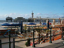
Netherlands (355 km)
| E11 in the Netherlands | |
|---|---|
In the Netherlands, the E11 only runs along *LAW 3 pedlar path from Scheveningen (a seaside resort and fishing village of The Hague) via Amersfoort, Deventer and the border town of Oldenzaal to Bad Bentheim in Germany. From Deventer, the trade road (Deventer - Osnabrück) part of the E11, up to Bad Bentheim in principle with the same course as the Marskramerpad, but small differences are possible. The route can be followed from The Hague to Deventer via Waymarkedtrails.
pedlar path
Probably in no other European country are hiking routes changed as often and so drastically as in the Netherlands. This may have to do with the population density, the systematic approach to spatial planning, or perhaps the way in which walking in the Netherlands is organised. Anyway, in the last guide of the Marskramerpad (2009 edition) the website already reports 55 changes (as of December 2012), one of which (between Achterveld and Terschuur) adds 8 kilometers to the route. If you want to walk the Dutch part of the E11, it is therefore very wise to consult that website before setting off (see also: http://www.wandelnet.nl/routewassenen-marskramerpad-law-3/meldingen scroll to "Changes with regard to tracing".) Of course, this also applies to the information at the back of the guide about bus and train connections and accommodation options.
From the starting point in Scheveningen, the white-red marked Marskramerpad runs through a number of parks and estates in The Hague and Wassenaar, crosses the commuter village of Voorschoten and takes a city walk through the large old center of Leiden (the largest old city center in the Netherlands after Amsterdam). Then it goes via Leiderdorp and Zoeterwoude-Rijndijk into the polders of the Green Heart of Holland, where (for example at Hoogmade, Woubrugge and Rijnsaterwoude the reed fringes in the reservoir waters are often used, or the last remaining lakes (at Nieuwveen, Zevenhoven, Noorden, among others). especially on the border with the province Utrecht you may find yourself surrounded on all sides by water and walk on a narrow strip of land.
In Breukelen you not only cross the ugly industrial Amsterdam-Rhine Canal, but also the picturesque Utrechtse Vecht with its estates and patrician houses from the seventeenth and eighteenth centuries. Then again peat areas follow, until higher land is reached at Maartensdijk: the Utrechtse Heuvelrug. Here the E11 searches for the woods around Soest to reach the city of Amersfoort via the Amersfoortse Berg. Here too a walk through the old center, which, however, could have been a bit more extensive to do Amersfoort justice.
After Amersfoort follows the Gelderland Valley where the E11 passes through small tufts of forest, such as at Leusden, Stoutenburg, Stoutenburg Noord, Achterveld and Terschuur, and then in the hamlet of Appel of the municipality of Nijkerk the extensive forest area of the Veluwe to stock up. Stroe, Kootwijk, Hoenderloo and Beekbergen lie like small oases in this forest, which by the way was completely bare in 1700 and has since been shaped by foresters. After Beekbergen, the open landscape of the IJssel valley begins, but the E11 also manages to find the scarce plots of forest here, for example at Klarenbeek and Wilp. The opportunity to walk across the IJsseldijk here is missed here.

On the other side of the IJssel is the historic city center of Deventer, which can be reached by ferry. After the beautiful center follows a long journey through the suburbs until the varied landscape of salland is reached. The Holterberg rises from it as a continuous forest area and is also the border with Twente. Via the town of Rijssen and the estate Twickel near Delden, the old capital of Twente, Oldenzaal, is reached, which used to be the end point (actually the starting point) of the Marskramerpad. Now the section E11 to the German border and Bad Bentheim is also included in the Marskramerpad. Because of the last 13 German kilometers, the Marskramerpad is just a bit longer than the Dutch part of the E11: 368 KM.
See also: Hiking Platform — Marskramerpad (2009), Two-Way Directions Guide and Detailed Maps 1:25000. ISBN 978-90-71068-78-2
trade road
Under the name "Handelsweg" two successive sections of the E11 are commercially exploited, which together cover exactly the territory of the EUREGIO, from Deventer to Osnabrück. From Deventer to Oldenzaal, the Handelsweg is similar to an older version of the Marskramerpad; from Oldenzaal to Bad Bentheim on the former course of the Töddenweg there, and from Bad Bentheim to Osnabrück on the still valid route of the Töddenweg (see below). The total length is 229 km. Arrangements with accommodation and luggage transport can be booked through the ECC Foundation. The beautiful guide has now been replaced by a set of three maps that can be downloaded or ordered via www.Handelsweg.com.
see also: http://www.Handelsweg.com. Website with downloadable maps of the route Deventer - Bad Bentheim - Osnabrück of the E11. It is also possible to book overnight stays and luggage transport on this route.
Germany (996 km)
| E11 in Germany | |||||||||||||||||||||||||||||||||||||||||||||||||||||||||||||||||||||||||||||||||||||||||||||||||||||||
|---|---|---|---|---|---|---|---|---|---|---|---|---|---|---|---|---|---|---|---|---|---|---|---|---|---|---|---|---|---|---|---|---|---|---|---|---|---|---|---|---|---|---|---|---|---|---|---|---|---|---|---|---|---|---|---|---|---|---|---|---|---|---|---|---|---|---|---|---|---|---|---|---|---|---|---|---|---|---|---|---|---|---|---|---|---|---|---|---|---|---|---|---|---|---|---|---|---|---|---|---|---|---|---|
| |||||||||||||||||||||||||||||||||||||||||||||||||||||||||||||||||||||||||||||||||||||||||||||||||||||||
The German part of the E11 includes some regional hiking trails, a last remnant of the old Fernwanderweg Harz — Niederlande as well as a newly designed extension after the fall of the Berlin Wall and the Iron Curtain via Berlin to Frankfurt (Oder). The marking is not the same everywhere and regional designations predominate. But every now and then one is reminded that one is walking the E11. The route gives a nice picture of the northern German landscape and the low ridges (dams) in it, albeit without the peculiarities of the coastal regions.
With the exception of the Töddenweg (Handelsweg), you have to rely on German texts for directions from the E11 in Germany. Topographical maps that do not require knowledge of the German language can be purchased from specialized hiking and map shops and from the organizations that manage the route. Also very practical are the atlases 1:200 000 by Falk and ADAC, which show the whole of Germany and show the course of Europe's long-distance routes remarkably correctly.
In general, people in Germany will be able to get by with some knowledge of English or an East Dutch dialect (Saxon, which in Germany is called Niedersächsisch or Niederdeutsch, or simply Platt). However, a good knowledge of English is less widespread in Germany than in the Netherlands.
Töddenweg and Wittekindsweg (218 km)
The first 13 kilometers on the German border today belong to the Marskramerpad, but used to be part of the Töddenweg. This now starts in Bad Bentheim and runs via Schüttorf, Rheine, Dreierwalde, Ostenwalde, Hopsten, Recke, Mettingen and Westerkappeln to Osnabrück (useful here: a set of three maps, which can be downloaded or ordered via Handelsweg.com. Accommodation and luggage transport can also be booked via the website). In its current form, i.e. from Bad Bentheim to Osnabrück Central Station, the Töddenweg is 110 km long. It is marked with a white capital T on a black square.
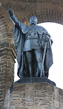
The Wittekindsweg forms the continuation and runs over the Wiehengebirge, from Osnabrück via Rulle, Mühlenort at Engter, Vehrte, Ostercappeln, Wehrendorf, Barkhausen, Oberbauerschaft and Bergkirchen to Porta Westfalica. Just before the spectacular descent to the finish, you pass the monumental building in honor of Emperor Wilhelm I, which is also clearly visible from the train or from the highway. It is over 95 km long and owes its name to Widukind or Wittekind, the first Duke of Saxony and army commander in the time of Charlemagne. The route is marked from Osnabrück to the hamlet of Mühlenort under Engter with the usual white cross on a black background in West Germany, then with the white-red stripes that are common in the Netherlands and Belgium. The Wittekindsweg is drawn from Osnabrück to the Wittekindsberg (south of Minden) on map 750 of Kompass.
Both the Töddenweg and the Wittekindsweg are managed by the Wiehengebirgsverband Weser-Ems. Via the website topographical maps and a guidebook with maps and directions in German can be ordered.
eastern Lower Saxony and Harz (186 km)
Until now, the E11 ran in the border area of the federal states of Lower Saxony and North Rhine-Westphalia, after Porta Westfalica it will remain permanently in Lower Saxony for a long time. First follows a third regional hiking route, the Wesergebirgsweg. It is followed over a length of 50 km over the ridge of the Weser Mountains to the center of the picturesque but commercial town of Hamelin. The E11 sometimes passes breathtaking rock formations and here reaches a height of 440 m on the Hohe Egge, a peak of the Süntelberg.
Shortly before Hamelin, the European Hiking Route E1 joins the E11. The joint descent to Hamelin (here the E1 goes in the other direction) takes the E11 in the open lowland along the rivers Weser and Hamel, until the next moraine, the Ith, is reached just before Coppenbrügge. This is also followed over the full length over the ridge, with the result that the walker has little opportunity to do shopping for days. It goes past Eschershausen with a wide bend to the old Alfeld and over the Helleberg to Bad Gandersheim and Seesen.

In Seesen, the Harz reaches. Majestic peaks over 1000 meters (the famous Brocken alone reaches 1141 m) now flank the route on the right, which, however, after a few peaks of around 500 m (Hohenstein, Grosser Baltenberg) sticks to the lowlands and visits some well-known historic towns : Goslar, Ocher and Bad Harzburg. Just south of Eckertal, 136 km after Hamelin, the border with the federal state becomes Saxony-Anhalt reached the former German-German border. The river Ecker forms the border to just below the Brocken.
Detailed information about this part of the route can be found in the German language in Der E11 through the Norddeutsche Mittelgebirge, running from Porta Westfalica to Halle (see also: Der E 11 durch das norddeutsche Mittelgebirge (2010); fernwege.de; ISBN 978-3-937304-80-9 (340km); Description E11 from Porta Westfalica an der Weser to Halle an der Saale. (the) , also see Fernwege.de (the) ). The route is also marked on hiking maps of the area, both on local and regional publications and on the Kompass maps (450 for the entire Seesen - Lutherstadt Eisleben section, or 451 for the section up to Bad Harzburg). This part of the E11 is always indicated in the field with a white cross on a black background (sometimes only a black or white cross). Where confusion is possible with other routes, the letter N is sometimes added; which stands for the old route "Niederlande-Harz-Weg". However, the designation "X11" that is occasionally encountered refers to another route that intersects with the E11 here and there. At Goslar, the European Hiking Route E6 crossed.
Harz and Saxony-Anhalt (244 km)
In the 1990s, the Harzklub made an effort to extend the E11 eastwards. This has resulted in a completely new route through the state Saxony-Anhalt resulted. Only in the Harz could existing local hiking trails be used. Via Ilsenburg, Wernigerode, Thale and Gernrode it continues on the flanks of the mountain range, until a passage through the massif finally begins at Ballenstedt. Via Pansfelde and Wippra the southern side of the Harz is reached and soon Eisleben, the birthplace of Martin Luther. Until here one can use map 450 from Kompass, or map 452 (Bad Harzburg - Thale) and 453 (Thale - Lutherstadt Eisleben).
Around Eisleben, the forests and mountains are definitely over: Here mining and agriculture dominate until the E11 near Höhnstedt enters the "Nature Park Lower Saale". Via Schochwitz and Dölau you arrive in Halle. What is special is that this large city came out of the Second World War almost undamaged and therefore provides a rare good picture of the architectural styles that were successively popular in Germany. The route is drawn on the Kompass map 457 and partly on local map publications.
Apart from the climb up the lonely Petersberg hill, the E11 after Halle again runs through open and flat land, former Prussian landed estates that were used by large agricultural companies in the GDR. Often an entire village was employed by a single company. Since the reunification of the two Germanys, many of these villages have had great difficulty giving their economies a new direction. Sometimes this is possible with the help of Dutch farmers who are building a new future here after they had to sacrifice their land in the Netherlands to urban expansion. International companies also see good opportunities here and there in the high unemployment and set up production companies and distribution centers here.

Via Görzig and Quellendorf it goes to the Mosigkauer Heide, which is the gateway to the city of Dessau, known to lovers of architecture and art as the city where the Bauhaus art school was located during its greatest heyday. The route can be found on Kompass map 458. After Dessau and the suburb of Naundorf, an exciting walk follows through the Middle Elbe Biosphere Reserve, via Vockerode and Wörlitz to Coswig. At Coswig this makes way for woodland. The border with the federal state of Brandenburg is reached between Senst and Groß Marzehns. This part of the route can be found with Kompass map 456 or 747.
Until Halle an der Saale, the German-language website Fernwege.de offers good information about the course of the route; A hiking guide with route description (in German) can also be ordered via this website, as well as a set of maps that together completely cover the route in Saxony-Anhalt. Just like in the Harz, the route is indicated here in the field with a diagonal cross (black on a white background or white without a background). There is no description between Halle an der Saale and Coswig, but there is map material and partly also markings; the E11 is clearly marked in the atlases 1:200,000 from Falk and ADAC. There is no marking between the Petersberg and the Mosigkauer Heide (west of Dessau). From Coswig, the route is described in "Wanderungen durch Brandenburg" (see below). In Quellendorf near Coswig, the usual Central European marking begins, a horizontal blue stripe on a white square.
Brandenburg and Berlin (348 km)

The E11 crosses the federal states of Brandenburg and Berlin, winding in a West-East direction. The route is described in German in Europäische Fernwanderwegen E 11 in Brandenburg and Berlin, running from Coswig via Potsdam and Berlin to Frankfurt an der Oder (see also: (the) Wanderungen durch Brandenburg, Unterwegs auf den Europäischen Fernwanderwegen E10 and E11, Trescher Verlag. Description of E10 and E11 in the state of Brandenburg (2003). ISBN 978-3-89794-033-8 ). A list with 150 addresses where overnight stays can be found in the German language "Übernachtungsverzeichnis zum europäischen Fernwanderweg E11 in Brandenburg" (see also: (the) bernachtungsverzeichnis zum europäischen Fernwanderweg E11 in Brandenburg, ISBN 978-3-937304-41-0 ). The website Fernwege.de also offers a description in German, albeit too brief to find the route without detailed maps.
The marking in the terrain is almost always the usual horizontal stripe on a white square in Central Europe, but the color varies: to Luisium blue, then red to Wörlitz, then blue again to Klein Glienicke, then a yellow one in former West Berlin. X. Where the E11 at Friedrichshafen rejoins the former GDR area, the yellow Central European marking takes over, followed by red from the Erpetal to Neuhardenberg and finally blue again to Frankfurt (Oder).
Until Belzig, the barren landscape, marked by large-scale Prussian and later communist agriculture, dominates. After picturesque Belzig, the route crosses the former hunting forests of the Prussian nobility. About 20 kilometers before Potsdam you reach the first of a series of lakes that flank the route far into Berlin. Before Potsdam, the banks have been taken over by numerous holiday resorts from the time of the GDR; many of these are now lying unused; some offer shelter to the passing walker. This part of the E11 is on maps 747 and 745 of Kompass. At Potsdam Central Station, the E11 intersects with E10.

Potsdam is followed by a long walk through Berlin, which is much more than just a city walk. On the border of Potsdam and Berlin, the route offers an exciting piece of history: The erratic course of the border between "East" (Potsdam) and "West" (Berlin) and the location of three tiny West Berlin enclaves within the territory of Potsdam led to this that both camps stationed a large number of spies in Klein Glienicke on the Wannsee. Some successful escape tunnels were also dug. Now it is mainly a romantic transition from the tight civil servant city of Potsdam (capital of the federal state of Brandenburg) to the extensive recreation area of West Berlin. Straight through the woods you reach the Olympic Stadium, which serves as a gateway to the built-up area of Berlin.[1] It is recommended that you bring a map of Berlin with you.
Charlottenburg, the first city district to cross the route, is interesting for its palace, many museums and other characteristic buildings. Anyone who wants to follow the E11 strictly afterwards is forced to walk along the Spree and the Landwehrkanal to the old city district of Köpenick. It is of course more interesting to go to the heart of Berlin via the Straße des 17. Juni, which is known from Love Parades, the Reichstag building (once set on fire by the Dutchman Marinus van der Lubbe), the Brandenburg Gate and the famous Unter den Linden alley. and pick up the Spree again near Museum Island and Alexanderplatz.
For the time being, the E11 follows the south bank of the Spree, first through a neighborhood with many dilapidated buildings and then through a few parks. At the end of the Plänterwald a ferry provides the crossing to a vast area with allotments. The E11 leaves the Berlin city area via Köpenick and Friedrichshagen. Then follows one of the most beautiful parts of the E11, the walk along the Erpe or Neuenhagener Mühlenfließ. It continues via Neuenhagen and the Märkische Schweiz to Gusow near Seelow. Here, two variants offer the continuation to Frankfurt.[2] The western variant runs through the woods of the Lebuser Heuvelrug to Jacobsdorf; the eastern variant follows the river Oder from Reitwein.
Poland (1242 km)
| E11 in Poland | |||||||||||||||||||||||||||||||||||||||||||||||||
|---|---|---|---|---|---|---|---|---|---|---|---|---|---|---|---|---|---|---|---|---|---|---|---|---|---|---|---|---|---|---|---|---|---|---|---|---|---|---|---|---|---|---|---|---|---|---|---|---|---|
| |||||||||||||||||||||||||||||||||||||||||||||||||
In Poland, the E11 continues in an easterly, later northeasterly direction, via Międzychód, Poznan, toru and Olsztyn to Ogrodniki on the Lithuanian border, not far from the border triangle with Belarus.

Poland is an extremely forested country; 30% of the surface is forest.[3] The route therefore mostly runs through forests, which range from meager production forest for the mines to wild deciduous forest with a wide variety of flora and (avi)fauna (70% of the Polish forests consist of conifers). Bovendien leggen de vele meren en vennen langs de route eigen accenten in het landschap. Enkele mooie en historisch interessante steden worden aangedaan of op korte afstand gepasseerd, zoals Międzyrzecz, Poznań, Gniezno, Toruń and Olsztyn. Naarmate men verder van de grote steden en de spoorlijnen verwijderd is, worden de mogelijkheden om te overnachten zonder tent en het openbaar vervoer schaars tot zeer schaars. De wandelaar moet rekening houden met dagetappes van 25 tot 35 kilometer.
In Polen zijn geen nationale of regionale wandelroutes in de E11 opgenomen. De E11 springt steeds van de ene op de andere lokale of regionale wandelroute om deze na een betrekkelijk korte afstand weer te verlaten. Daardoor wisselt de markering in het veld herhaaldelijk van kleur (wel wordt steeds het Midden-Europese Markeringssysteem gevolgd; een gekleurde horizontale balk op een wit vierkant veld). De markering is steeds die van de route die men ter plaatse volgt; de E11 wordt bijna nergens als zodanig aangeduid. Na Strzelno loopt de E11 vaak samen met de Jacobsweg, die met gele schelpen op blauwe achtergrond is gemarkeerd.
Het precieze verloop van de E11 in Polen is te ontlenen aan vier moeilijk toegankelijke bronnen:
1. Hans Jürgen Gorges: "Auf Tour in Europa; Das Handbuch für die Europäischen Fernwanderwege", uitg. Kompass i.s.m. de Europese Wandel-Federatie, 1999/2000 en 2002, ISBN 3-8134-0338-6 (volledig uitverkocht, ook tweedehands). Dit is een (verouderende) opsomming in lijstvorm van de plaatsen waarlangs de elf Europese Wandelroutes lopen, alsmede details van de markering, aan de hand waarvan men de route kan terugvinden op:
2. Oddział Topograficny Sztabu Gen.WP: Mapa Topograficzna Polski §, waarbij voor § het nummer van de betreffende kaart moet worden ingevuld. Deze en meer gedetailleerde kaarten kunnen - ook vanuit Nederland en België - worden besteld bij de gespecialiseerde kaartenhandel www.Grupa18.pl in Poznań.[4]
3. Latere wijzigingen in de route kunnen (in de Poolse taal) worden gevonden op het kantoor van de PTTK, de Poolse pendant van de ANWB, alsmede
4. op het kantoor van de Europese Wandel-Federatie te Praag.
Aan de hand van deze bronnen en eigen ervaring is de onderstaande route zo goed mogelijk gereconstrueerd. Bij plaatsen met logiesmogelijkheden is de afstand vanaf het begin van de etappe aangegeven.
Oderbrug - Międzyrzecz (141 km)
Kaarten: N-33-125/126 en N-33-127/128. Aanduidingen als "geel" en "groen" geven de markering in het veld aan. Op kaart N-33-125/126 Op de is de E11 niet aangegeven; op kaart N-33-127/128 is de E11 vanaf Trebów aangegeven.

Vanaf de Oderbrug begint direct de gele markering.Na twee kilometer over de Oder dijk gaat het linksaf naar het kleine dorpje Drzecin. Van Kursko tot Bodowice maakt de E11 een grote lus rondom de stad Międzyrzecz die busverbindingen heeft met diverse dorpen op de route en treinverbindingen met Poznań en Duitsland. Op deze lus liggen Kęszyca Leśna met een voormalig kazernecomplex van het Rode Leger (waar men kan logeren in de villa van de officieren), Kęszyca waar een voormalig Duits kazemattensysteem uit de jaren 1920 bezocht kan worden (hier doet zich de unieke gelegenheid voor een deel van de E11 ondergronds af te leggen tegenwoordig natuurreservaat voo vleermuizen niet te bezoeken), en Gościkowo Paradyż, waar het gelijknamige klooster in renaissancestijl wandelaars gastvrij opneemt, mits zij zich voegen naar het kloosterleven. Hier begint ook de groene markering die naar Bobowicko en verder voert. Międzyrzecz is een levendig stadje met streekmuseum.
Overnachtingsmogelijkheden in Stubice,Rzepin (4 km van de route) Osno Lubuskie, Radachow, Lubniewice, Blednew ( 2 km van de route), Kursko, Keszyca Lerna, Jordananowo ( in Nw. Dworek), Szumiaca en Mydzyrezecz.
Oderbrug tussen Frankfurt (Oder)]] en Słubice - centrum Słubice - Drzecin - Stare Biskupice - Sułów - Drzeńsko - Lubiechnia Wielka - Lubiechnia Mała - Ośno Lubuskie (34 km) - Trzebów - Jarnatów - Lubniewice (67 km) - Osiecko - Bledzew (78 km) - Chycina - Gorzyca - Kursko (93 km) - Kęszyca Leśna (100 km) - Kęszyca - Rez. Nietoperek - tussen Kaława en Wysoka - Gościkowo Paradyż (112 km) (groen) - Szumiąca - Bobowicko (141 km).
Międzyrzecz - Poznań-Kiekrz (133 km)
Kaarten: N-33-127/128, N-33-129/130 en N-33-117/118. Op deze kaarten staat de E11 niet vermeld, maar de routes waarlangs hij loopt, zijn in de regel wel in kleur weergegeven. De route loopt veelal door bossen, hier en daar zijn de paden niet onderhouden en overwoekerd. Het deel tussen Szamotuły en Poznań-Kiekrz is niet gemarkeerd.
Wie voor de eerste overnachting Międzychód te ver vindt, kan in Villa Toscania overnachten, een eenzaam hotel tussen Nowe Gorzycko en Stare Gorzycko. Het dubbelstadje Międzychód-Bielsko biedt veel gelegenheid om te winkelen (mode, antiquiteiten, kunst). Hierna loopt de route lange tijd door voormalig grensgebied: in 1919 lagen hier de Duitse en Poolse fronten; op tableaus is de geschiedenis (in het Pools) weergegeven. Na Słopanowo maakt het bos plaats voor open landschap. In het dorp Kiekrz wordt de stad Poznań bereikt. In het centrum van Poznań is allerhande logies te vinden, waaronder hostels waar veelal Engels wordt gesproken, bijvoorbeeld Frolic Goats, Ulica Wrocławska 16/6.
Bobowicko (groen) - Żółwin - Kuligowo - Stołuń - 1 KM voor Rybakówko (blauw) - Villa Toscania (27 km) - Stare Gorzycko - Słodewy Młyn - Międzychód (33 km) - Bielsko (36 km) - Ławicá - Góra - Sieraków (53 km) - Piaski - Bucharzewo -Bukowar (rood) - Pustelnia - Jezioro Radziszewskie (groen) - Ghojno-Wies (rood) - Chojno-Młyn - Chojno Błota - Mokrz - Wronki (88 km) - Obrzycko]] (99 km) (groen) - Słopanowo - Kobylniki - Twardowo - Szczuczyn - Szamotuły (113 km) (geen markering) - Kepa - Baborówko - Pamiątkowo - Krzyszkowo - - Starzyny - Poznań-Kiekrz (133 km).
Door Poznań (33 km)
Kaarten: stadsplattegrond van Poznań.
Tussen Sołacz en Rondo Środka is geen specifieke route voor de E11 aangegeven, maar het ligt voor de hand via de tramhalte Nad Wierzbakiem naar het Rynek Jeżycki te lopen. Daar begint de "Route van Koningen en Keizers",[5] die in rechte lijn langs bijna alle bezienswaardigheden van Poznań voert en eindigt bij het middeleeuwse kerkje van Sint-Johannes van Jeruzalem. Volgt men de rustige noordzijde van het meer Jezioro Maltańskie[6] met de miniatuurspoorbaan, dan kan men ter hoogte van de dierentuin de zwart gemarkeerde Cisterciënzer fietsroute vinden, die met vele kronkels en omwegen de stad uit loopt. Net over de stadsgrens, in Gruszczyn, kan men overnachten of de bus terug naar Poznań nemen.
Poznań-Kiekrz (groen) - Golęcin (zwart/blauw) - Sołacz, Nad Wierzbakiem (geen markering) - Rynek Jeżycki - Route van Koningen en Keizers via het Rynek naar Rondo Środka - Krańcowa/Nowe Zoo (zwarte Cisterciënzer fietsroute) - Poznań-Antoninek - Poznań-Zieliniec (33 km).
Poznań-Zieliniec - Gniezno (55 km)
Kaart: N-33-131/132. De E11 is niet op de kaart aangegeven; de Cisterciënzer fietsroute slechts tussen Poznań-Antoninek en Pobiedziska. In werkelijkheid loopt deze fietsroute in Gruszczyń linksaf om twee kilometer verderop te eindigen bij het station van Kobylnica. De E11 gaat evenwel in Gruszczyn rechtdoor langs een andere zwart gemarkeerde fietsroute. Deze loopt door een rommelige mengeling van akkers en industriële bedrijvigheid tot vlak voor de buurtschap Pomo (niet op de kaart vermeld, in de buurt van Promienko, dat wel op de kaart staat). Hier gaat het met een haakse bocht linksaf naar een stenen pilaar die diverse fiets- en wandelroutes aangeeft. Hier gaat het rechts het bos in over een zandweg. Midden in het woud, op een kruising met een wit-groen-wit gemarkeerde wandelroute slaan de E11 en de fietsroute rechts af om de groene route te volgen tot ruim na het oversteken van een asfaltweg alle markering ontbreekt. Hier kan men het beste een wit-blauw-wit gemarkeerde wandelroute volgen in oostelijke richting, totdat blijkt dat deze route ook de groene wandelroute, de zwarte fietsroute en dus de E11 is. Dit alles is niet uit de kaart af te leiden, omdat deze daarvoor te globaal is.
De gecombineerde route slaat op een tweede asfaltweg linksaf om na enige honderden meters als blauwe wandelroute rechts af te slaan. Na een ruime kilometer door het bos (eerst over een pad, daarna "struinend") wordt een stenen pilaar bereikt, die aangeeft dat de groene route hier naar links en de blauwe naar rechts afslaat. Beide routes verliezen zich even later in het struweel zonder enig spoor van markering, zodat er niets anders opzit dan terug te gaan naar de asfaltweg en deze te volgen naar Pobiedziska, waar de E11 teruggevonden kan worden.
Het gedeelte tussen Pobiedziska en Gniezno is zeer slecht gedocumenteerd. Het hier beschreven tracee is uitsluitend ontleend aan een overzichtskaart die is geplaatst op het centrale plein bij de kerk van Trzemeszno.
In Pobiedziska leidt een duidelijk gemarkeerde fietsroute naar het station. Dit is echter alleen een service voor treinreizigers, want de E11 en twee fietsroutes slaan zonder enige aanduiding de weg in die op het centrale plein van Pobiedziska bij de kerk begint (Ulica Gnieźnieńska). Een kilometer verderop steekt de E11, nu zwart gemarkeerd als fietsroute, de spoorbaan over naar het noorden. Via Glówna (de links afslaande fietsroute 12 negeren; rechtuit de niet genummerde fietsroute volgen) gaat het naar Węglewo. Hier tweemaal rechtsaf en even buiten het dorp linksaf een onverharde weg inslaan met spaarzame markering. In Moraczewo (500 meter voor de gevaarlijk drukke autoweg 5) buigen de E11 en de fietsroute linksaf naar Lednogóra, waar blijkt dat men inmiddels ook een wit-rood-wit gemarkeerde wandelroute volgt. Wie deze bij de kerk naar rechts volgt, komt na drie kilometer op een kruispunt met autoweg 5. Recht vooruit is de schreeuwerige neonreclame van een hotel zichtbaar; naar links wijst een bordje richting de jeugdherberg van Dziekanowice en naar rechts geeft een wegwijzer van de rode wandelroute aan dat het nog 22,2 km naar Gniezno is.
De E11 verlaat nu de fietsroute en volgt de komende honderd kilometer de rode wandelroute. Deze is tot Gniezno slecht gemarkeerd, maar daarna goed te vinden. Kort na het kruispunt bij Dziekanowice niet de spoorbaan oversteken, maar evenwijdig met de rails doorlopen tot het station van Fałkowo waar weer markering wordt aangetroffen. De route steekt Fałkowo nu in de volle lengte door. Een laatste rode pijl wijst aan de andere kant van het dorp vertwijfeld in de diepte (althans in september 2011); tussen Fałkowo en Leśniewo heeft de route plaats moeten maken voor de bouwput van een autosnelweg. Hierna is de rode markering met enige moeite te volgen tot Gniezno.

Gniezno is in de Middeleeuwen de eerste hoofdstad van Polen geweest, maar is nu een provinciestadje met een aardig historisch centrum en vele interessante kerken. De E11 en de rode route lopen langs de belangrijkste bezienswaardigheden, waaronder de Vallei der Verzoening tussen de beide heuvels waarop Gniezno gebouwd is.
Poznań-Zieliniec (zwart gemarkeerde Cisterciënzer fietsroute) - Gruszczyn (1 km) (zwart gemarkeerde fietsroute) - Uzarzewo - Biskupice - Rez. Jezinowo Dębiniec (groen) - Rez. Drazynek (blauw) - bos bij Kapalice (geen markering) - Pobiedziska (22 km) (zwart gemarkeerde fietsroute) - Glówna - Węglewo - Moraczewo - Lednogóra (rood) - kruispunt bij Dziekanowice (33 km) - Fałkowo - Leśniewo - Pierzyska - Wożniki - Gniezno (55 km).
Gniezno - Toruń (136 km)
Kaarten: N-33-131/132, N-34-121/122, N-34-109/110 en N-34-97/98. De E11 wordt op deze kaarten niet vermeld; de gemarkeerde routes die de E11 volgt, gedeeltelijk wel, namelijk tussen Gniezno en Trzemeszno. Van Trzemeszno tot Strzelno is de route ingetekend op een plaatselijk uitgegeven detailkaart.[7]
Voor het station van Gniezno geven enkele bordjes afstanden langs wandelroutes aan. Voor Mogilno wordt correct 40 km gegeven, maar de afstand tot Kruszwica wordt zwaar overschat. De E11 verlaat Gniezno over een goed gemarkeerde wandelroute door een modern industrieterrein en enkele nieuwbouwwijkjes te midden van bos. De rode markering leidt de wandelaar zonder problemen door een open landschap van akkers en plukjes bos naar het langgrekte industriedorp Trzemeszno. Bij het station steekt de route de spoorbaan naar het noorden over om via een paar dorpjes Mogilno te bereiken. Er zijn drie dorpjes met de naam Wydartowo; daarvan passeert de route het grootste, een dubbeldorp met Duszno.

In Mogilno sterft de rode markering uit. De route doet het station aan en rondt dan het meer tot een in 1065 gesticht Benedictijnenklooster. Nu verlaat de E11 de stad over een drukke verkeersweg naar het Oosten tot Bystrzyca, neemt dan een binnenweg naar Olsza, om over de lange dorpsstraat van Podgaj, Kawka en Goryszewo Kwieciszewo te bereiken. Vlakbij het plaatselijke motel staat een eenzame rode markering. De rode route en de E11 verlaten Kwieciszewo over een zandweg die ten zuiden van autoweg 15 en min of meer parallel eraan naar het oosten loopt. Tot net in het bos vindt men enige rode markering en bij het verlaten van het bos voor Jeziorki opnieuw. Een zandweg brengt de wandelaar tot in Strzelno (waar het op kaarten aangegeven hotel voorgoed gesloten is).
Ook na Strzelno blijft het zoeken naar sporen van markering en naar de juiste route. Wat helpt, is dat de E11 hier samenloopt met de Camino Polaco, de Jacobsweg naar Compostella in het noordwesten van Spanje. Dat blijft in grote lijnen zo tot het eindpunt van de E11 op de Litouwse grens. Voorlopig kunnen dus ook de gele schelpen op blauwe achtergrond gevonden worden - maar ook daarvan zijn er niet al te veel. Strzelno wordt vanaf de mooie barokke kerk via Starozowo verlaten en daarna gaat het via Ksiaz naar Polanówice. Daar hangen twee verroeste en grotendeels onleesbaar geworden bordjes die nog duidelijk de rode markering en de aanduiding "E11" laten zien - zo'n 200 km na de vorige vermelding van de E11 in het terrein!
Van Polanówice gaat het over een aantrekkelijk bomenlaantje in noordoostelijke richting naar Kruszwica. Kruszwica heeft enkele aantrekkelijke kerken. Vanaf de brug aan de noordzijde loopt een duidelijke blauwe markering tot in het centrum van Inowrocław. De blauwe route eindigt na een rondwandeling door het centrum bij het busstation.
.jpg/220px-Inowroclaw_Teznie_(1).jpg)

Bij het station van Inowrocław staat een afbladderende stadsplattegrond waarop een rode route te zien is die in oostelijke richting de stad verlaat. Dat is de E11; op sommige punten in de stad heeft de rode verf nog standgehouden. De route maakt een rare slinger noordwaarts en leidt tot een oorlogsmonument. Iets voor het oorlogsmonument rechts (Błonie), terug naar de weg Jacewska oostwaarts. Bij Bursztynowa rechts, en bij de grote weg weer links. Na enkele honderden meters buigt de grote weg naar rechts en gaat een zandpad door. Dat pad is de route naar Turzany en Balczewo. De st Jacobsroute volgt via de bossen naar Parchanie, vanaf waar de rode route samen met de rode markering oploopt tot vlak voor Gniewkowo. Let op: het pelgrimspad gaat rechtsom naar de stad, de E11 linksom even en westen van een fabriek en langs het station. Hier verschiet de E11 van kleur. Een goed gemarkeerde blauwe wandelroute, versterkt door de gele schelpen van de Jacobsweg en een groene fietsroute, voert door de stad en over de weg naar Cierpice het bos in. Anders dan Gorges meldt, gaat de route sinds 2010 niet meer via Suchatówka.
De E11, tevens Jacobsweg bereikt met een nog ruimere bocht dan de asfaltweg na 16 km bos Cierpice, het eerste van een lint van voorstadjes van Toruń. Beide routes slingeren kruisen het spoor, om vervolgens direct naast het spoor op(!) de spoordijk te lopen - in Nederland is dit ten strengste verboden, hier staat de markering op de elektriciteitsportalen over het spoor.

Vervolgens over verharde wegen tussen verspreide bebouwing tot voorbij Mała Nieszawka. Hier gaat het zonder markering linksaf een betonplatenweg in die na ongeveer een kilometer over de rivierdijk klimt en daarna in de uiterwaarden het oeverpad bereikt. Hier gaan de routes rechtsaf en wordt weer markering aangetroffen die langs ruïnes en tenslotte over de brug naar Toruń leidt.
Gniezno (rood) - Pławnik - Kędzieryn - Nowe Wieś Niechanowska - Krzyżówka - Miaty - Trzemeszno (23 km) - Niewolno - Folusz - Wydartowo-Duszno - Izdby - Gozdawa - Wyrobki - Mogilno (41 km) - Bystrcyza - Olsza - Podgaj - Kawka - Goruszewo - Kwieciszewo (51 km) - Jeziorki - Strzelno (zowel rood als Jacobsweg) - Starozowo - Ksiaz - Polanowice - Lagiewniki - Kruszwica (72 km) (Jacobsweg) - Szarlej - Łojewo (blauw) - Szymborze - Inowrocław (87 km) (rood) - Turczany - Balczewo Parchanie - Wierzbiczany - Gniewkowo (106 km) (blauw) - Cierpice (122 km) - Mała Nieszawka (130 km) - Toruń (136 km).
Toruń - Brodnica (87 km)
Kaarten: N-34-97/98, N-34-109/110 en N-34-99/100. Op deze kaarten wordt de E11 niet vermeld, maar de geel (goed) gemarkeerde route waarvan de E11 gebruik maakt is tussen Toruń en Golub-Dobrzyń en tussen Pólka Duża bij Kupno en Brodnica in paars aangegeven. Op kaart N-34-99/100 wordt tot Pólka Duża (dat niet op de kaart vermeld wordt) een fout tracee aangegeven.[8]
De E11 en de Jacobsweg doen in het authentieke stadscentrum van Toruń alleen het kantoor van de PTTK aan, om daarna tussen stadsmuur en rivier de stad te mijden. Mooier en praktischer is het om vanaf het PTTK-kantoor dwars door het centrum over de Różana, de Szeroka en de Wielkie Garbary naar het treinstation Toruń-Miasto te lopen en daar de route weer op te pikken. Zo komt men langs de belangrijkste bezienswaardigheden en diverse hotels en hostels.
Buiten de stad passeert de E11 het Fort Sobieskiego, gaat dan schuin rechts het bos in de uiterwaarden van de Wisla in, maar moet zich al na twee kilometer een weg gaan banen door voorstadjes van Toruń, Kaszczorek en Złotoria. Vervolgens wordt een groot bos doorkruist naar Brzozówska.
Meteen na het oversteken van de drukke A10 slaat de E11 schuin links een overwoekerd pad in om via een zandweg Mierzynek te bereiken (de kaart toont nog het vroegere tracee via Szembekowo). Hier loopt men nog in open terrein, maar voorbij Lelitowo begint een lang bostraject, dat alleen wordt onderbroken door het stadje Ciechocin. Daarbij wordt globaal de rivier de Drweca stroomopwaarts gevolgd tot de sfeerrijke dubbelstad Golub-Dobrzyń wordt bereikt. Via een brug over de Drweca bereikt de E11 het oude centrum. De bedoeling is om ca 500m verderop bij een begraafplaats de Drweca weer te kruisen, maar die brug was in 2014 afgesloten wegens verval. Om die reden kan vanaf het centrale plein direct weer de eerste brug rechts genomen worden, om langs de Drweca te vervolgen tot aan de vervallen brug.
In eerste instantie wordt de rivier opgezocht en, nu mèt markering, gevolgd, maar bij Plonko gaat het rechtsaf naar Szafarnia, een van de dorpen in de regio die met een museum herinnert aan de componist Chopin. De route loopt nu meestal door open akkerland, maar zoekt tussen Płonne en Tomkowo voor korte tijd het bos op.
In Radziki Duże gaat het linksaf over een asfaltweg naar een immense zand- en kiezelafgraving (veel zwaar vrachtverkeer!) om na circa 5 km de brug over de Drweca te bereiken. Meteen over de brug slaat de E11 een bospad in dat linea recta naar Mszano leidt. De route doet het dorp Szabda niet meer aan, maar volgt rechtuit de rivier naar een verre buitenwijk van Szabda. Vier vervelende kilometers langs een drukke autoweg leiden naar de stad Brodnica.
Toruń (geel) - Kaszczorek - Złotoria - Brzozówka (20 km; motel op 1 km in Glogowo, Dobrzejewice) - Mierzynek - Lelitowo - Ciechocin (32 km; logies bij Elgiszewo op 2–4 km) - Dulnik - Antoniewo - Golub-Dobrzyń (44 km) - Białkowo - Szafarnia (53 km) - Płonne - Rodzone - Tomkowo - Kierz Radzikowski - Radziki Duże - Kupno - Pólka Duża - Słoszewy - Mszano - Brodnica (87 km).
Brodnica - Olsztyn (237 km)
Kaarten: N-34-99/100, N-34-87/88, N-34-89/90 en N-34-77/78. Op deze kaarten staat de E11 niet vermeld, maar de onderliggende routes zijn over het algemeen wel ingetekend. Daarbij wordt een gele markering met paars weergegeven. Uitzondering: Tussen Marianowo en Ostrowite ontbreekt de route op de kaart.[9]
De E11 verlaat Brodnica goed gemarkeerd, maar zonder het oude, verwaarloosde stadscentrum aan te doen. Langs de drukke A15, dan langs een oude spoorbaan en opnieuw langs de A15 gaat het tot over de bruggen bij Tama Brodzka. Hier begint met een scherpe hoek linksaf een lang bostraject dat tot Jezioro Zbiczno goed gemarkeerd is (de Jacobsweg volgt vanaf Bachotek een ander tracee). Daarna loopt de E11 samen met een groen gemarkeerde route tot een asfaltweg wordt bereikt waar alle markering ontbreekt. Hier gaan beide routes rechtsaf, om na een doorsteek tussen twee meren met een bocht naar links het asfalt te verlaten. Hier gaan de gele E11 en de groene route uit elkaar.
De E11 slingert in noordwestelijke richting, kruist bij Leśniczówka Rytebłota de asfaltweg van Zbiczno naar Ciche en verlaat tenslotte bij Górale voor korte tijd het bos. Juist als het dorp wordt bereikt, gaat de E11 met een scherpe hoek terug naar de bossen, via Wonka naar Ostrowite. Nu volgt een gedeelte tussen lintbebouwing tot bij het station van Ostrowite en scherp rechts tussen akkers, maar steeds over asfalt naar Łąkorek.
In Łąkorek slaat de E11 linksaf, maar wie aan slapen toe is, dient hier rechtsaf over de asfaltweg naar Ciche te lopen. Om terug te komen op de E11 kan men uiteraard dezelfde weg terug nemen, maar veel aantrekkelijker is het om in de bossen ten Oosten van Ciche de groen gemarkeerde route op te zoeken die na Bachotek al over enkele kilometers samenliep met de E11. Deze is één groot feest van ongetemde natuur in alle denkbare vormen, na Ciche 8 km lang tot het kruispunt met de E11, 2 km ten Oosten van Łąkorek. Volgt men de groene route van Bachotek tot dit kruispunt (circa 12 km), dan bespaart men zich een 32 km lange en wat saaie lus in de E11.
Vanaf dit kruispunt loopt de E11 naar het Oosten, later Noordoosten. Bij Sluzka verlaat de route het bos om door open land de opmerkelijke kerk van Gryżliny te bereiken. Hier is een nieuw tracee gevonden tot Radomno, waar de Jacobsweg er weer bij komt. Aan de oostkant van een reeks meren lopen beide routes recht naar het Noorden naar Iława.
De routes lopen samen dwars door de moderne stad Iława naar het aan watertoerisme gewijde Szałkowo. Door open land wordt Wiewiórka bereikt en daarna door bos het station van Samborowo. Hier eindigt de gele route; de E11 volgt vanaf het station blauwe markering. In het dorp Samborowo gaat het even rechtsaf, waarna over 9 kilometer een oude spoorbaan wordt gevolgd. Door het strekdorp Pietrzwald worden de bossen rond Wysoka Wies bereikt, waarna het door afwisselend landschap naar Grunwald gaat. Grunwald is vooral bekend als pelgrimsplaats voor Polen en Litouwers die een middeleeuwse veldslag tegen de Ridders van de Duitse Orde willen herdenken. Nog steeds vinden daar jaarlijks ridderspelen plaats.
Na Grunwald beheersen akkers en weilanden het beeld langs de hier en daar overwoekerde E11. Dat verandert radikaal na Waplęwo; nu gaan bomen domineren, variërend van rechttoe-rechtaan productiebos tot een oerbos gelijkend resultaat van minimaal beheer. Onnodig te zeggen, dat flora en fauna hier door vele zeldzame soorten vertegenwoordigd zijn. Het onbetwist hoogtepunt van deze etappe is het natuurreservaat Las Warmiński, dat in de volle lengte doorlopen wordt. Pal daarop komt de liefhebber van moderne volkswoningbouw aan zijn trekken: de E11 loopt drie kilometer langs een drukke verkeersweg door de nieuwbouw van Olsztyn, voordat het oude centrum wordt bereikt.
Brodnica (geel) - Tama Brodzka (7 km) - Bachotek (13 km) - Jezioro Zbiczno - Leśniczówka Rytebłota (23 km) (overnachting mogelijk te Ciche op 2 km) - Górale - Wonka (39 km) - Ostrowite - station Ostrowite - Osetno - Łakorek (50 km; overnachting in Ciche op 4 km)) - kruispunt met groene route - Sluzka - Skarlin - Lekarty - Gryźliny - Radomno (73 km) - Katarzynki - Iława (85 km) - Szałkowo (91 km) - Tynwałd (99 km) - Frednowy - Wiewiórka - Samborowo (112 km) (blauw) - Turznica - Gruda - Naprom - Pietrzwald (129 km) - Wysoka Wies (132 km) - Dylewo - Marcinkowo - Samin - Grunwald (156 km) - Ulnowo - Lubianek - Sitno - Waplęwo - station Waplęwo (zwart) - afslag naar Maróz (183 km; overnachting in Maróz op 1 km) - Żelazno (geel) - Łynski Mlyn (groen) - Orłowo - Likusy - Brzezno Łyńskie (203 km) - Kurki - Las Warminski - Rus - Bartazek - Jaroty (232 km) - Olsztyn (237 km).
Olstyn - Kętrzyn (137 km)
Kaarten: N-34-77/78, N-34-65/66, N-34-67/68 en N-34-69/70. Op deze kaarten wordt de E11 niet met name genoemd, maar de onderliggende routes zijn ingetekend in de kleur waarmee ze in het veld gemarkeerd zijn (gele markering wordt op de kaart met paars weergegeven). Uitzondering: het gedeelte van Lidzbark Warmiński tot Kętrzyn is niet op de desbetreffende kaarten aangegeven. Wel kan men de route vanaf Reszel blauw gemarkeerd op een uitgave van PPWK/Copernicus vinden.[10]
Olsztyn leent zich door zijn historische centrum (tot 1945 maakte de stad alonder de naam Allenstein deel uit van Oost-Pruisen) voor een langer verblijf. De E11, nu met de rode markering van het Copernicuspad, verlaat de stad in het Noorden onder een torenhoog treinviaduct en volgt opnieuw de rivier de Lyna door oeverbossen. Hier heeft de buitensport van Olsztyn een hoge vlucht genomen; op de andere oever zijn tal van boomklimtuinen zichtbaar en een circuit voor quads en gemotoriseerde mountain bikes is soms hoorbaar. Deze stadsdrukte houdt op bij de Most Smętka, een brug ruim voor het dorp Dywity (dat op afstand wordt gepasseerd). De E11 biedt hier een 30 km lange boswandeling tot Swobodna. Dan gaat het de open velden rond het pilgrimsdorp Głotowo door tot in het stadje Dobre Miasto, een van de vele plaatsen met een door de Ridders van de Duitse Orde gebouwde kerk.
Na Dobre Miasto volgen enige kilometers langs een tamelijk drukke verkeersweg, tot een kilometer voorbij Kunik. Hier gaan de E11 en het rood gemarkeerde Copernicuspad rechtsaf over een smalle asfaltweg naar het bisschoppelijk paleis bij Smolajny. Na een kronkel over het kerkelijk terrein steekt de rode markering een andere asfaltweg over en leidt dan duidelijk zichtbaar rechtuit het open terrein in, waar zij zich verliest in een moeras. Men kan de route vele kilometers verderop terugvinden door over de laatste asfaltweg naar het Oosten te lopen, het dorp Smolajny te doorkruisen en ongeveer 5 kilometer langs de drukke weg 51 naar het Noordoosten te lopen. Bij een grote parkeerplaats met speelterrein duikt de route in noordelijke richting het bos in. Nu volgt een eenzaam stuk door bossen en poesjta door het ontvolkte Wróblik en langs het kleine Nowosady naar Pilnik, een buitenwijk van Lidzbark Warmiński.
Precies 19 km na de kerk van Dobre Miasto bereikt de route over de Ulica Wiejska het begin van het uitgestrekte centrum van Lidzbark Warmiński. De rode markering van het Copernicuspad slaat hier linksaf; de torens van de stad lokken recht vooruit; maar de E11 begint hier naar rechts aan een zwart gemarkeerde, 6 km lange omweg door het dal van de Lyna die de hoogtepunten van de stad grotendeels overslaat. Het lijkt aantrekkelijker linea recta onderdak te zoeken in het centrum en de volgende ochtend ruim de tijd te nemen voor een bezoek aan de vele kerken en burchten van de Duitse Orde, het museum in het kasteel en de zwart gemarkeerde omweg daarbij mee te nemen. De omvang van het stadscentrum verraadt dat het hier om een hoofdstad van de Ridders van de Duitse Orde gaat, maar het Rode Leger heeft hier in 1945 danig huisgehouden en het is, ondanks de bouw van een groot aantal betonnen flatgebouwen midden tussen de eeuwenoude monumenten, niet gelukt de stad niueuw leven in te blazen.
Station Lidzbark Warmiński is het beginpunt van de blauw gemarkeerde route die de E11 nu tot Kętrzyn volgt, een afstand van 69 km. De eerste kilometers voeren langs een militaire begraafplaats uit de Eerste Wereldoorlog en dan, min of meer recht naar het Oosten, door akkers en weilanden naar het klooster van Stoczek Klasztorny (Warmiński), dat voor pelgrims en andere wandelaars een slaapkamer gereed houdt. Via de verspreide boerderijen van Stoczek leidt de blauwe markering naar Kiwity en, langs een verrassend rustige verkeersweg, door Rokitnik. Even voor een groot hotel slaat de route rechts een zandweg in naar het dorp Sulowo. Steeds tussen akkers en weilanden door wordt Bisztynek bereikt, een stadje dat sinds de deportatie van de Duitse bevolking in 1946 een kwijnend bestaan leidt.
De E11 verlaat, nog steeds blauw gemarkeerd, Bisztynek over een oude spoordijk die door dicht bos naar het Noordoosten gaat. Na 4 km slaat de route een zandweg in die min of meer parallel aan het oude spoor loopt naar Nowa Wieś Reszelska en, inmiddels geasfalteerd, het station van Sątopy-Samulewo. De E11 steekt een verkeersweg over, passeert rechtuit een wijkje met woningblokjes, draait naar rechts in een vooroorlogse buurtschap en komt dan uit opeen met boerengeriefhout overwoekerde oud karrenspoor. Na een kilometer struinen wordt bij een brug een verkeersweg bereikt. Die volgt de route naar links, langs Troksy, Biel en Czarnowiec naar Reszel, een stadje dat toeristen weet te trekken met zijn historische centrum, kerk en kasteel uit de tijd van de Duitse Orde, en een uitgebreid culinair aanbod.
Reszel uit gaat het bijna 2 km over een oud spoortracee, en dan een zandweg rechtsaf richting Święta Lipka, een populair bedevaartsoord aan de Jacobsweg van Litouwen naar Spanje. Na de drukte van deze trekpleister zoekt de E11 de stilte van het bos op en loopt noordwaarts, dan met een scherpe bocht naar het Oosten over een oude spoordijk achterlangs Pieckowo. Korte tijd wordt een asfaltweg gevolgd en dan opnieuw het oude spoor totdat de route de woningblokken van het industriedorp Smokowo passeert. Over de toegangsweg van het dorp gaat het verder naar Biedaszki en, langs een drukke verkeersweg, naar Kętrzyn. Dit is een levendige stad die niet alleen teert op zijn historische architectuur uit de riddertijd en later eeuwen, maar ook de functie van streekcentrum vervult.
Olsztyn (rood) - Os Wojska - Braswald - Barkweda - Strusiolandia (18 km) - Cerkiewnik - L. Chmury - Swobodna - Głotowo (32 km) - Dobre Miasto (37 km) - Kunik - Smolajny - Wróblik - Nowosady - Pilnik - Lidzbark Warmiński (62/68 km) (blauw) - Sarnowo - Stoczek Klasztorny (Warmiński) (80 km) - Kiwity (85 km) - Rokitnik (88 km; hotel op 1 km) - Sulowo - Bisztynek (94 km) - Nowa Wieś Reszelska - Sątopy-Samulewo - Troksy - Biel - Czarnowiec - Reszel (114 km) - Święta Lipka (121 km) - Pieckowo - Smokowo - Biedaszki - Kętrzyn (137 km).
Kętrzyn - Gołdap (118 km)
Kaarten: N-34-67/68 en N-34-69/70. Op deze kaarten wordt de E11 niet met name genoemd, maar de onderliggende routes zijn ingetekend in de kleur waarmee ze in het veld gemarkeerd zijn (gele markering wordt op de kaart met paars weergegeven). Wel kan men de route vanaf Kętrzyn blauw gemarkeerd op een uitgave van PPWK/Copernicus vinden.[10]
Kętrzyn is een langgerekte stad en het treinstation ligt ongeveer in het midden, ten zuiden van het centrum. De stad herbergt diverse monumenten uit de riddertijd van de Duitse Orde en geldt als een touristische trekpleister. Er zijn dan ook talrijke hotels en andere logiesgelegenheden, waaronder een jeugdherberg, hostel Aria en "hotelik" Zajazd Pod Zamkiem, een beetje verscholen naast het kasteel bij het station (110 złoty per kamer). De blauw gemarkeerde route loopt om het kasteel heen, steekt een drukke weg met gescheiden rijbanen over en volgt de even drukke weg 593 de stad uit. Meteen na een kruising met een stilgelegde spoorbaan slaat de route linksaf naar en doorheen het dorp Karolewo. Kort na een oude begraafplaats verlaat de route de asfaltweg om rechtsaf een stenige veldweg in te slaan. Deze voert na een bocht naar links het dorpje Czerniki in, langs een agroturystik. Nog voor het centrum is bereikt, gaat het rechts over een hobbelige weg de velden in, later het bos in en om het meer J. Siercze langs een vakantieoord met tennisbanen slingerend door nu eens statige, dan weer weelderige loofbossen tot een asfaltweg wordt bereikt. Aan de overzijde is de ingang van een voormalig hoofdkwartier van Adolf Hitler (hij heeft er tenminste dertien laten aanleggen). Niet alleen is het terrein tegen betaling van 15 złoty te bezichtigen (voor 80 złoty gaat er een gids mee); je kunt er ook slapen in het voormalige hotel voor SS- en SD-officieren, in sobere kamers voor 80 (1-p.), 120 (2-p.) en 170 (3-p.) złoty. Op het terrein zijn naast vele vervallen of opgeblazen bunkers enkele kiosken en restaurants aanwezig. De Duitse naam van de streek, Goerlitz, is in het Pools verbasterd tot Gierłoz, maar de oude naam Wolfsschanze voor de eigenljke vesting wordt steeds gangbaarder.
Officieel loopt de nog steeds goed gemarkeerde route nu over de smalle asfaltweg naar het oosten verder, maar het is veiliger om even terug te lopen, dus tegenover de entree van de Wolfsschanze weer het bospad in en rechtuit tot je op een betonplatenweg stuit. Die volg je naar links tot je ter hoogte van een onduidelijk houten bouwwerk (een schaapskooi in gebruik als overdekte picknicklaats?) toch weer op de asfaltweg uitkomt. Je bent nu het bos uit en passeert aan je linkerhand Park Miniatur Warmii I Mazur dat a la Madurodam een aantal ridderburchten en andere monumentale gebouwen uit de omgeving in miniatuur uitstalt (entree 20 złoty). Voor kinderen worden hier allerlei activiteiten georganiseerd die iets met het thema oorlog te maken hebben.
De route slaat in het dorpje Parcz linksaf, verlaat de asfaltweg bij de spoorbaan en volgt naar rechts geruime tijd een zandweg, eerst door landbouwgronden, dan vele kilometers slingerend door loofbossen. Het einde van de blauwe route wordt met een duideljke stip aangegeven; hier kies je de rode route naar links (er loopt ook een blauwe fietsroute mee). Door open velden bereik je Radzieje waar een winkel en bankjes een alternatief bieden voor de hier niet meer aanwezige horeca (vroeger was er een pension dat nog op oudere kaarten staat aangegeven). De rode route heeft inmiddels een scherpe bocht naar rechts gemaakt, dus teruglopend uit het dorp ga je schuin links weer een zandweg tussen akkers op. Die brengt je eerst naar Łabapa en vervolgens naar de entree van het dorp Sztynort Duża, de geboorteplaats van de Duitse schrijfster Marion Graefin von Doenhoff die veel heeft betekend voor de verbetering van de Duits-Poolse verhoudingen na de Tweede Wereldoorlog. Een gedeelte van haar geboortehuis (de Doenhoffs behoorden tot de hoogste adel van Oost-Pruisen en het huis verdient de naam paleis) is in min of meer vervallen toestand in gebruik, onder andere als pensionat en café-restaurant. Ertegenover zijn tal van op de watersport gerichte bedrijven en terreinen te vinden.
Dat watersport hier centraal staat, zal niet verbazen, want de nu zwart gemarkeerde route loopt, na enkele kilometers door bos, over een smalle landtong tussen twee gedeelten van de uitgestrekte Oost-Mazurische merengordel. Dat betekent niet alleen 8 km asfalt met langs zoevende zware personenauto's die een aanhanger met een boot trekken, maar ook schilderachtige doorkijkjes op het water, zowel naar links als naar rechts. Er zijn diverse slaapgelegenheden voor de kleine beurs, zoals pokoje (huurkamers) en een agroturystik. Uiteindelijk bereik je het dorp Harsz, waar diverse pokoje worden aangeboden. Volg je de zwarte route op het eerste kruispunt meteen naar links, dan vind je in Stara Skola een pensionat (75-130 złoty per persoon) waar de Poolse uitbaatster vloeiend Engels en Frans en minder vloeiend Duits spreekt.
In Harsz volgt de route de asfaltweg langs het meer, maar even buiten het dorp slaat ze linksaf een veldweg in en na 1 km rechtuit een overwoekerd graspad dat door drassig terrein naar een eenzaam huis leidt. Hier gaat het rechtsaf een veldweg op naar een kleine installatie en enkele huizen. Even verderop slaat de route opnieuw linksaf het hoge gras in; de markering brengt je naar Róg, vanwaar je rechtsaf een onverharde, later smalle asfaltweg terug naar de hoofdweg door de dorpen kiest. De hoofdweg brengt je naar links langs een luxe hotel naar Ogonki, dat logies in alle prijsklassen biedt. In Ogonki sla je opnieuw linksaf en langs een drukke weg bereik je enkele winkels. Sla hier voldoende in, want de eerstkomende 40 km zul je geen winkel of horeca meer tegenkomen.
In Ogonki verruil de E11 de zwarte markering voor blauwe, die scherp rechtsaf in de Ulica Sckolá begint. Al snel bereik je op een voormalige spoordam een uitgestrekt bosgebied, waar een van de meest avontuurlijke delen van de E11 ligt. Niet alleen wijkt de blauwe markering in het terrein zichtbaar af van wat op de beide detailkaarten staat ingetekend, maar bovendien houdt de blauwe markering bij een splitsing op het oude spoortracee op. Blijf je hier de spoordam volgen, dan zie je resten van markering waaruit niet valt op te maken of het hier om de wandelroute gaat, dan wel om een blauwe fietsroute of blauwe aanwijzingen voor houthakkers. Na verloop van tijd raakt de dam steeds meer overwoekerd en tenslotte leidt een klein paadje je naar links omlaag op een bosweg die parallel aan het tracee verloopt en even verder uitkomt op een andere zandweg (te herkennen aan het feit dat hij naar rechts met een grote boog over een viaduct over de oude spoorbaan gaat). Deze zandweg volg je naar links om een driesprong te bereiken waar de blauwe wandelroute van links komt en zich erbij voegt. Rechtuit is de wandelroute nu goed te volgen over een afstand van ruim 2 km, maar pas op: na de laatste (verse) markering sta je binnen enkele meters kniediep in het water van een ondergelopen vallei. Heb je toevallig een bootje bij je en kun je de aanvallen van twee zwanen pareren, dan kun je rechtuit varen en midden in de vallei rechtsaf slaan, om de route over anderhalve kilometer terug naar het westen te vervolgen; hier krabbel je op een punt waar markering ontbreekt de tegenoverliggende oever op en loop je rechtuit tot je weer op de spoordam bent. Zonder boot zul je evenwel een kilometer terug moeten lopen naar een brede zandweg die je nu naar links volgt over nog eens een kilometer. Uiteindelijk maakt de weg een ruime bocht naar links en kruist de oude spoorbaan. Hier sla je linksaf en op de spoordam vind je na circa 500 meter de blauwe markering van de wandelroute terug.
De E11 en de blauwe wandelroute blijven nu op de spoordam tot bij een grote bunker die daar in de Tweede Wereldoorlog door Himmler is neergezet bij wijze van hoofdkwartier. Een kilometer verderop bereik je de entree en enkele flats van het stadje Pozezdrze. De route slaat echter linksaf en volgt over ruim 4 km een rustige asfaltweg. Kort na de bushalte van Przytuly volgt de E11 de blauwe markering rechtsaf een weg met kinderhoofdjes op, eerst tussen velden, dan het bos in en tenslotte op geringe afstand van een meer aan de rechterhand. Via de verspreide huizen van Wilkus kom je in Jasienczyk. Hier kun je overnachten in een van de kampeerhuisjes van camping Aneta (140 zloty per huisje); bar, restaurant en kampwinkel zijn alleen in het hoogseizoen geopend. Loop je de bosweg verder af, dan bereik je een asfaltweg die je rechtsaf met een brug over een uitloper van het meer en bij Jasieniec brengt. Hier verlaat de E11 de blauwe markering. Op een kruispunt neem je naar links de groen gemarkeerde asfaltweg (dus niet de groen gemarkeerde fietsroute die een half verharde bosweg inslaat) naar Zabinki (logies mogelijk in "noclegi").
In Zabinki wijkt de markering af van wat er op de kaarten staat en slaat een halfverharde weg naar rechts in die tussen de velden door loopt, steeds begroeider en drassiger wordt en een meertje passeert. Tenslotte kom je bij Diable Góra (waar ooit Hitler's luchtafweergeschut stond) uit op een brede verharde weg. Die volg je naar rechts en meteen daarop naar links, tussen een kapotte picknickbank en natuurreservaat Brodi door. In weerwil van afslagen gaat de route nu steeds rechtuit, opnieuw over een overwoekerd bospad tot je tenslotte op een brede grintweg uitkomt. Op een splitsing (waar de Jacobsweg naar rechts gaat), slaat de groene route met de E11 linksaf en volgt over bijna 4 km de wegwijzers naar Czerwony Dwór. Onverwacht gaat het dan toch weer rechtsaf naar het kleine natuurreservaat Lipowy Jar en het Pilwag-meer, en dan met een boog weer terug naar de asfaltweg. Die bereik je bij Lesny Zakatek, een voormalige jeugdherberg die nu voor opleidingen wordt gebruikt. Hier slaat de E11 rechtsaf en passeert even verderop het jachthuis Lesny Zakatek 2, de enige plek in het bos waar je kunt overnachten (tel. 49609052850; 70 zloty p.p. voor slapen met avondbrood en ontbijt). Naar Czerwony Dwór zelf is het nu nog een kleine 2 km.
In het dorp houd je bij de bushalte rechts aan (links zijn twee winkeltjes); buiten het dorp gekomen op een halverharde weg sla je na anderhalve kilometer linksaf naar Olszanka. Opnieuw wijkt de markering af van wat er op de kaarten staat: de route slaat even rechtsaf en tegenover een boshuis linksaf naar het dorpje Zawady Oleckie. Here at the crossroads turn left and 2 km further you reach a agroturystik and after another 2 km the village of Jablonowo with a shop and a bus stop. The green marker takes you out of the village on a path that soon becomes lush and overgrown between the fields and through the forest. If you lose the marking here, it is best to stroll east along the cornfields in the forest; with a bit of luck you will end up in the village of Golubie Wezewskie. Along the Szeska Góra (Szeszki's mountain) you reach the village of Szeszki and further forest roads take you to Wilkasy. Here you follow the asphalt road to the left; at a fork in asphalt roads turn left again and at the end of Kamionki village turn right. Now follows a long and beautiful route over the highest hills of Mazurie; you reach 300 m altitude. At the end of this wide semi-paved road lies the city goldap. Major expansion plans ensure that you reach the center of the town with various windings over access roads and around entrances and exits. In what is perhaps the largest central square in Europe, you will find the [www.UzdrowiskoGoldap.pl tourist information] where you can book accommodation in all price ranges and use the internet for free. In Goldap there are supermarkets, restaurants and a large sports complex with swimming pools and sauna.
Kętrzyn - Karolewo - Czerniki (5 km) - Gierłoz/Wolfsschanze (10 km) - Parcz - 3 km after Parcz (red) - Pilwa - Radzieje (20 km) - Łabapa - Sztynort (28 km) (black) - Sklodowo (32 km) - Col. Harsz (33 km) - Harsz (36 km) - Róg - Ogonki (44 km) (blue) - Pozezdrze (51 km) - Sapieniec - Przytuli - Wilkus - Przerwanki - Jasieńczyk (accommodation in camping cabin Aneta, 62 km) - Przerwanski ( 64 km) - Jasieniec (65 km) (overnight stay is possible in Jeziorowski, 2 km) (green) - Żabinki (66 km) - Diable Góra - Rogonie - Lesny Zakarek (82 km) - Czerwony Dwór - L. Olszanka - agroturystika Jablonowo 18 (91 km) - Jablonowo - Golubie Wężewskie - Wilkasy - Kamionki - Pietrasze - Suczki - Osiedłe - gołdap (118km).
Gołdap - Lithuania (165 km)
After gołdap the route runs through the nature reserve Puszcza Romincka and the hilly province Podlaskie; often through protected or unprotected areas with beautiful nature. In summer the weather is about the same as in the Netherlands and Flanders (albeit with less rain); in winter it is considerably colder. In the Puszcza Romincka you can choose from a green and a red variant. Cards: N-34-69/70 and N-34-71/72; only for the green variant of . described below gołdap to Stanczyki also N-34-57/58. At the tourist information in Goldap a detailed map 1:40.000 of the Park Krajobrazowy Puszczy Rominckiej is for sale, showing the red and the green route from Goldap to Stanczyki. Also useful is the map "The land of five towns", 1:160,000, which shows the locations of many accommodation options.
In Gołdap, stock up enough, because now you won't come across a shop for 50 km if you follow the green route. This route, which still carries the E11, takes the second right on the main square of Gołdap and follows the fairly busy road 651 for 5 km. A red walking route joins it on the outskirts of the town. After winding through an old railway viaduct you can choose from the red marked walking route to the right (past the former Botkuny station), or another kilometer further along the 651 with the green route. The green route that the E11 already follows from Jasieniec now runs for approximately 25 kilometers through lonely forests close to the Russian border (exclave Kaliningrad, Koningsbergen) to finish in Stanczyki after a total of 31 kilometers.
In a bend of road 651 to the right at Jurkiszki (agroturystik), the green route continues straight into the woods, crosses a blue trail twice and, 4 km after Jurkiszki, in forest plot 103, exchanges the semi-paved road for a forest path to the right. After more than 2 km this leads to another semi-paved road that follows the E11 to the left to turn right at a swampy area. After some time this forest road ends at a three-fork on a small road paved with cobblestones that makes two bends to the left. Pay close attention to the marking, because if you miss the turn to the right, you'll be walking into Russia within 600m - without any warning other than a rusty right of way sign with an exclamation mark. So turn right into the dirt road; the route is still well marked despite the many windings and the sometimes lush vegetation. Finally, 24 km after Jurkiszki, the E11 crosses Road 651 (a kilometer to the right is a bus stop) and turns into a wide dirt road. After a kilometer and a half, the green marking turns right twice, onto an overgrown forest path that, another kilometer and a half further, leads under a viaduct to the parking lot at an old "Talbruecke" of the Prussian railways. The rails were broken up and taken away by the Russians in 1945, and after that all of East Prussia was given to Poland, so Prussian or other trains no longer run here. The railway viaduct does have the name of being the highest in Poland, but that is probably old fame: the highest in East Prussia, yes that is possible, but in the south of Poland you can definitely find higher viaducts in the mountains, which are also are still in use.

The red route chooses a stony road through the hamlet of Botkuny. It walks into the woods, keeps left before an old viaduct and then comes to walk on the dam of the old railway. Soon you are on top of a barely recognizable railway viaduct with dangerous chasms on both sides (you look at the tops of the trees). The red route continues to follow the track until an unmarked point where it makes a sharp left turn into another semi-paved road. This will take you to the village of Galwiecie (if you miss this exit, the railway will take you to road 651 and you will have to walk back to the left). In Galwiecie (bus stop) the route crosses road 651 straight on and winds between the settlement of the village and the ruins of the outbuildings of a restored manor house to a semi-paved road through the farmland. With a large curve you reach the old railway again, 4 km after Galwiecie; a little further is Pluszkiejmy (bus stop). Now follow the railway track to the left until you come to a fork under a viaduct. Here you turn left of the low-lying railway track and choose straight ahead onto the asphalt road to Budwiecie. At the entrance of this hamlet, the red route takes a forest road to the right, which ends at a T-junction after 4 km. Here you choose the way to the right and you come out of the forest between a few farms. At a second T-junction, turn left to Bludzie Wielkie. With a red-marked bicycle route you arrive in Zabojady where you keep left to Będziszewo. Now follow some winding paths through the forest, after which you reach road 651 in Bląkały (shop, bus stop). A few hundred meters to the right on road 651 you will find the old railway. First the red route runs parallel to this on an asphalt road; then over a tall grassy bank of a stream until 2 km after Bląkały you can see the Stańczykach bridges. The bridges of Stanczyki are a regional attraction that requires an entrance fee (€0.50pp) to walk on them. The red route turns to the right and after less than a kilometer you reach the inn Zajazd Bialy Dwor (room with 2 meals 73 zoty) in Stańczyki. Next to it is an agroturystik and after a pendulum uphill the red route over the asphalt reaches the parking lot of the old railway viaduct.
From the car park, the E11, now marked in red, ascends to the old railway line to follow to the right for a mile and a half. Then follow a right angle to the right and a dirt road to the village of Maciejowięta (agroturystik). Left through the village and left again after the village, back to the old railway. Back on the railway you pass memorial stones that remind of the disappeared village of Golubben. Eventually you reach the village of Poblędzie, always going straight on the semi-paved road. By now you have crossed an important historical frontier: Old Prussia with Old Russia. And that can be seen in the architecture: suddenly there are wooden farms and the landscape looks Lithuanian instead of German. Through the village, the E11 meets a yellow route and cycle route R65 at a junction; here you follow the three routes to the right until a crossroads. Here the E11 leaves the red route (and cycle route R65) to turn right with the yellow marking (and cycle route R68). The cycle route soon turns right again, but the yellow marking takes the E11 via the hamlet of Klajpedka to the village of Klajpeda. At the chapel of the village you take the asphalt road to the left past a bus stop and before the agroturystik turn right on a semi-paved road to and through the hamlet of Dziadówek. After the climb through the village you reach a three-fork where a black and a red route start (indicated by a thick dot). Map N-34-69/70 incorrectly indicates that the E11 would follow the black route; in reality she follows the yellow and red route to the right. Less than 200 m further on, the yellow route splits off to the left; the E11 now follows the red route due south and rises steeply between the scattered buildings of Dzierwany to a crossroads with a bar with a large garden. Again the E11 changes color; she now follows the blue route for 2 km to the left until a T-junction where a green marking also appears.
At this point you can turn left after 1 km to reach the first agroturystiken of Smolniki (Goscienny Jaćwing also includes overnight trekkers; room with two meals 75 zoty), or after another second kilometer (past the church and two cemeteries) a bus stop, a shop and some houses with rooms for rent.
However, the E11 turns right at the three fork and now follows the green markings for the next 28 km. The first 2 km also follows an educational trail with trilingual information boards about the area, which consists of rare untouched nature with rich forests on steep hills along several lakes. After sign 9, the E11 turns right into a dirt road to cross the stretched village of Udziejek after another 3 km on an asphalt road. Here you pass an agroturystik that will undoubtedly do well with children. At the end of the village the E11 turns right into a semi-paved road that leads to some farms on another semi-paved road. There is not enough marking here, but the intention is that you follow the blue marking to the left here until you see the green marking again: Between a house and its outbuildings you come to an overgrown wagon track between the fields, which flows into a romantic valley full of flowers and tall grass. The track is barely visible here; keep to the left of the valley until you see the markings on the trees again. It then takes you over a path on the shore of a lake to Góra Zamkowa, where black and yellow markings also meet. Here you turn left until the big agrturystik Czajewszczyzna. At the crossroads, the other routes are marked, but the green ones (and thus the E11) are not; however, turn right and follow the educational trail that winds past two lakes to Kazimierówka (two agroturystiken). Via an asphalt road you reach the village of Jeleniewo with its striking large and high wooden church.
In Jeleniewo (to the left) are two agroturystiken and if you cross road 655 to take a closer look at the church, you will find on your right, on the other side of the park, a shop and snack bar. Here the E11 crosses road 655 again and goes straight between the school and the bank into a residential street. After the last houses you will find green marking; the route goes straight onto a cart track. The route has probably fallen into disarray here as a result of a land consolidation, because the maps here do not correspond to reality. Now head west as much as possible until you come across a north-south asphalt road and follow it to the left (to the south). Eventually you will find some green markings at a larger asphalt road and a bus stop, but it is not clear where it points you. It is best to take the larger road to the left (to the east) here until past the place name sign "Jeleniewo". In a bend of the road you turn right into a wide dirt road. If you follow it, you will find the green marking again after a three-way intersection; follow it to the left to find road 655 in the village of Prudziszki. In the village there are rooms for rent (pokoje) and on the south side there is a cafe and a shop.
Prudzyszki lends itself to a day visit to the big city Suwałki with its spacious neoclassical architecture. At the shop in Prudzyszki there is a bus stop where an occasional bus to the big city Suwałki stops. It is best to spend the night in the village, take an early bus to the city and return in the early evening. In the opposite direction, bus connections are significantly worse and accommodation in Suwałki is also expensive.
After the shop in Prudzyszki, the green marked E11 turns diagonally left into a semi-paved road, between scattered buildings through the forest. After 4 km, the green marking will bring you to the busy road 8, which crosses the E11 straight (careful!). Here begins a black-marked route that takes the E11 to Stary Folwark, alternating through forest and open terrain. Initially the route bends slowly to the left through forest, then comes to a lake in open area where the black marking almost disappears. The route here makes a wide arc around the lake, clockwise to Osinki. Here it goes left twice at a right angle and again into a forest with scarce markings. Then the route crosses a forest meadow, re-enters the forest, and loses the marking completely. Less than a thousand meters after the forest meadow, the E11 turns right twice (if you look closely, you will find a black mark on a hidden tree, which seems to indicate that you should have come from another side). You now walk eastwards on a wide dirt road until the black marking, after more than 1 km, suddenly turn left into a forest path. This runs through a lake; if you can't continue here, go back to the dirt road and follow it further to a crossroads. Here you go straight into an overgrown forest road. After a bend to the left, the marking is added from the left side.
Follow this country road, which has meanwhile emerged from the forest, until a railway crossing. Cross the railway (2 passenger trains per day; it is Poland's international link with the Baltic States and St Petersburg) and follow it back in the direction you came from. It is now best to follow the road to the left until you come to an asphalt road with a bus stop and the place name sign "Lipniak". On the asphalt you walk to the right until just in the village of Nowa Wies, where there would be a hotel. Scarce markings here lead you left onto a field road, which turns into an overgrown cart track between the fields. After about 2 km you will reach a sign for Wigierski Park Narodowy. Follow the semi-paved road to the right; a little further on, excellent signposting begins that leads the E11 to the village of Tartak (2 agroturystiks). Follow the black marker and after another kilometer you will arrive at Stary Folwark, a water sports center offering accommodation in all price ranges, as well as a shop, snack bar and restaurant. Stary Folwark has excellent bus links on the main road with Suwałki.
However, the E11 exchanges the black route for a short section along the main road, to the left, over a bridge, and after another 300 meters past some houses. Now the E11 with a green marked route turns right to Magdalenowo (agroturystik), Wigry (hotel, pokoje and baroque monastery a few hundred meters from the route), the Rosocharty Róg peninsula with cheap accommodation, and Kolajewo (pokoje). After the last house, the E11 goes up a forest path to an entrance to the Wigierski Park Narodowy and a crossroads of hiking trails. Here the E11 takes the blue route to the left, until Mackówa Ruda; at a picnic bench turn right to the hamlet of Wysoki Most (agroturystik).
The E11 goes straight on here over an asphalt road through open country, but after 700 meters it turns left into a semi-hardened forest road. If you pass through the forest in another agricultural area, you will come across a place name sign "Wysoki Most", albeit that there is no bridge in sight (most means bridge). Now keep following the blue markings on semi-paved roads through the villages of Buda Ruska and Jeziorki, until after a piece of forest suddenly a large church appears. The marker now dives into a yard near a house; to avoid difficulties with the residents, it is better to walk straight ahead to an asphalt road and follow it to the left, to and through the elongated village of Karolin. At a point at the end of the village where there is no markings, the E11 turns right into a wide semi-paved road. Further on, also without markings, you turn left and then right into the forest; you can also walk out of the semi-paved road to an asphalt road and follow the latter to the left until you see the marking again in the forest (you now have to follow it to the right). In the forest, the marker again lets you down; at a junction you have to follow a semi-paved forest road to the left until you have almost completely gone through Wiersnik. Here the blue marking points the way into a meadow and immediately upon arrival in Giby you will find an agroturystik on your left where people like to speak English.
The E11 continues to be the blue marker through this southern part of Giby. After about a kilometer it goes between two agroturystiken. Shortly before the main road 16, the route curves to the left to reach a bridge in the road past a few houses. The center of Giby starts over the bridge with shops, restaurants, a bus stop and more accommodation, but the E11 now turns red marked into the asphalt road to Zelwa. After 1 km you pass Campercamp which, contrary to its name, also allows sleeping in a tent or in guest rooms. The E11 follows the asphalt until it ends and then turns left to reach the extended village of Zelwa on a wide semi-paved road. Also here are agrturystiken.
The route has been changed at the bus stop with a shelter in Zelwa. Does the map still indicate that the red route turns right here; the markings now follow the asphalt further outside the village. In a bend of the road, the marking goes straight ahead, with an overgrown cart track along a protected nature reserve into the forest. Then follows a track through the forest, at a distance parallel to the road; given the scarcity of markings, you need a good sense of direction to arrive in Berzniki (the quiet asphalt road through Wigrance and Dubowo (agroturystik) offers a good alternative). In Berzniki there is a remarkable wooden church; furthermore there is a shop and two agroturystiken.
The E11 leaves Berzniki to the northwest past a war cemetery that recalls a victory of the Poles over the Lithuanians in 1920. It is tempting to take the asphalt road to Ogrodniki, but that is not the intention; the E11 turns right a road later (marking missing) and reaches the international road 16 through Polkoty and Dworczysko. The E11 crosses it straight, choosing a stony semi-paved road. At what may be called a single cemetery, markings indicate that the red route turns to the left, but a black route turns to the right. That black marking is supposed to guide the last nine kilometers of the E11, but it doesn't succeed. In a piece of forest, not only the marking disappears, but every trace of a passable road, so that there is no other option than to look for road 16 on a semi-paved road to the right and follow it to the left until the border crossing 3 km from Ogrodniki ( here you can find the black marking). Both Lithuania and Poland belong to the Schengen area and the European Union; so there is no more border controls, which has visibly killed many bars. You can exchange money there. This border crossing is the official terminus of the E11. There is a motel restaurant and just across the border in Lithuania is still a hotel.
Green marked variant: gołdap (green) - Jurkiszky (6 km) - Hajnówek - Blędziski - Stanczyki (33 km). Variant marked in red: gołdap (red) - Botkuny - Galwiecje (10 km) - Pluszkiejmy (14 km) - Budwiecie - Bląkały - Stanczyki (33 km). Next: Stanczyki (red) - Maciejowieta (36 km from gołdap) - Pobłedzjie (yellow) - Klajpedka - Klajpeda (49 km) - Dziadówek (red) - Dzierwany (blue) - three-way crossing (55 km) (1 km Smolniki) (green) - Udziejek (60 km) - Czairwszczyzna (65 km ) - Kazimierówka (69 km) - Jeleniewo (70 km) - Prudziszki (79 km) - intersection with highway 8 (=E67) (black) - Osinki - Lipniak - Nowa Wies (95 km) - Tartak (103 km and 1 km Stary Folwark) (green) - Magdalenowo (105 km) - Wigry (106 km) - Rosocharty Róg (109 km and 110 km) - Kolajewo (111 km and 112 km) - Węgzał (blue) - Maćkowa Ruda - Wysoki Most ( 118 km) - Gremzdówska - Jeziorki - Karolin - Wiersnik - Giby (133 km, 134 km, 135 km and 136 km) (red) - Zelwa (141 km and 143 km) - Berżniki (150 km) - Dworczysko - J.Szłabinki (black) - border crossing Ogrodniki (165 km).
To Moscow?
It was a beautiful dream after the fall of the Berlin Wall and the dissolution of the Soviet Union: a walking route from the Netherlands to Moscow. And it could also be so easy: cross the border at Ogrodniki, via the baroque center of Vilnius, by the still fairly untouched nature of the Aukštatijos Nacionalinis Parkas, between the lakes near the three-country point from Latvia, Lithuania and Belarus to Novgorod and Moscow, a distance of about 500 km. But organizational objections stand in the way between dream and deed: Lithuania, Latvia and Russia do not have hiking organizations that participate in the European Hiking Association, the manager of the European hiking routes. And so, for many years to come, the E11 will end at a remote border post in what was once called the Communist Eastern Bloc and is now the East of the European Union. Since 2016 there has been an organization for pilgrimage paths to Santiago de Compostela in Lithuania. Some route sections are now marked, which do not lead to Vilnius, but to the north. Routes to the east are now in the works. Via Druškininkai, and Vilnius, among others.
stay overnight
Community
The group of walkers on the E11 is small. on facebook is a community active. Among other things, she tries to make contacts for the continuation of the route to Moscow.
The route of the E11 is recorded in openstreetmap. Results of this can be found in waymarked trails.
Route descriptions and map material
Prames commissioned by European Hiking Association: Map of European Long-Distance Footpaths; Map of the Europäischen Fernwanderwege; Carte des Sentiers Européens de Grande Randonnée (2010), map and description of the EWV and its routes, available free of charge from (es) Prames.com and ERA-EWV-FERP.org
- ↑Compass Wander- und Radtourenkarte (1:50,000) No. 745 Havelland. ISBN 3-85491-505-5 with signed E11 between Golzow and the vicinity of Berlin-Grünewald.
- ↑Compass Wander- und Radtourenkarte (1:50,000) No. 746 Märkische Schweiz. ISBN 3-85491-506-3 with signed E11 between Köpenick and Frankfurt.
- ↑http://www.Waldwissen.net/lernen/Weltforstwirtschaft/wsl_Polen/index_DE, a German website about forestry worldwide.
- ↑[email protected]
- ↑http://en.Wikipedia.org/wiki/The_Royal-Imperial_Route_in_Pozna
- ↑http://en.wikipedia.org/wiki/Lake_Malta
- ↑Mogilno after Szlaku Piastowskim, edition Artem, Witkowo, 1:50 000, ISBN 83-913969-6-7
- ↑Henryk Miloszewski, PTTK: Informer 2, Szlak Żółty Toruń - Golub-Dobrzyń - Brodnica - Radomno. List of places along the E11 with their sights, published by PTTK Toruń.
- ↑Henryk Miloszewski, PTTK: Informer 2, Szlak Żółty Toruń - Golub-Dobrzyń - Brodnica - Radomno. Leaflet with a list of places and places of interest along part of the route.
- ↑ 10,010,1PPWK/Copernicus: "Gross Masurian Seen 1:100 000", ISBN 978-83-7697-003-5 , detailed map of the eastern part of Masuria.
| This is a guide article . It contains a large amount of good, quality information about relevant attractions, entertainment venues and hotels. Dive in and make it a star article! |
| This article incorporates information from the Wikipedia article Walking route E11. See the page history there for the list of authors. |