Map of australia
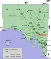
The Australian State South Australia (South Australia) borders in the west Western Australia, in the east Queensland, at New South Wales and Victoria, in the north of that Northern Territory. The country has many contrasts. The south is still quite agricultural, but if you drive north, the landscape becomes more and more arid and barren until you reach the desert. As a result, the majority of the population is in the south and east of Adelaide lives.
Regions

South Australia with Stuart Hwy and Indian Pacific
places
- 1 Adelaide


 in the Wikidata database") - the capital of the state.
- the capital of the state. - 2 Bordertown
- 3 Coober Pedy
- 4 Glenelg - Seaside resort and suburb of Adelaide.
- 5 Hahndorf
- 6 Kangaroo Island
- 7 Marree
- 8 Mount Gambier
- 9 Murray Bridge
- 10 Naracoorte
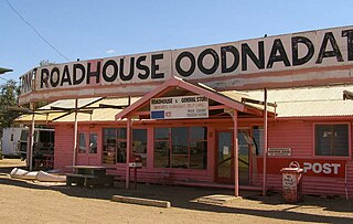
- 11 Oodnadatta
- 12 Penola - Center of a wine-growing region.
- 13 Peterborough

- 14 Port Augusta
- 15 Quorn
- 16 Victor Harbor
- 17 Whyalla
- 18 William Creek


.jpg/317px-Coober_Pedy_-_panoramio_(1).jpg)
.jpg/320px-Adelaide_-_Glenelg_Beach_(4158746916).jpg)


.jpg/350px-StateLibQld_1_127059_Aldergrove_(ship).jpg)


Other goals
background
language
getting there
By plane
In the street
By train
There are two trains a week from Adelaide to Melbourne. The luxury tourist trains also run from here Gahn to Darwin. The one who crosses the whole continent Indian Pacific makes on the way between Sydney and Perth also here station.
mobility
Tourist Attractions
activities
kitchen
nightlife
security
climate
trips
literature
Web links
- http://www.sa.gov.au/ - Official website of South Australia