The Ziller Valley (German: Zillertal) is the most important side valley of the Lower Inn Valley in Tyrol, Austria. The valley in the heart of the Alps is a popular destination for winter sports and for hiking.
Towns and villages

- 1 Schlitters

- 2 Hart im Zillertal
- 3 Ried im Zillertal
- 4 Fügen — its high elevation suburb Hochfügen is an international winter sports resort
- 5 Kaltenbach — the Hochzillertal ski resort
- 6 Uderns
- 7 Stumm
- 8 Aschau
- 9 Zell am Ziller — major winter sports destination
- 10 Hainzenberg
- 11 Schwendau
- 12 Brandberg
- 13 Mayrhofen — largest town in the Ziller Valley and major tourist hub
Other destinations
Understand
Orientation
The Ziller Valley is the widest of the southern Lower Inn Valley side valleys, branching off about 40 km east of Innsbruck. It stretches north-south over a distance of about 35 km from Strass im Zillertal until Mayrhofen, where the valley further splits into the Tuxer Valley to the west, the Zemm Valley, and the Stillup Valley.
At Zell am Ziller, the Gerlos Valley branches off to the east, leading to the 1 Gerlos Pass ![]() and the border with Salzburg.
and the border with Salzburg.
To the south, the Ziller Valley Alps form the mountain ridge between Tyrol and Italy. With peaks over 3,000 m, the ridge is nearly impassable and heavily glaciated. The Hintertux glacier, a popular winter sports destination in the Tuxer Valley, is one of these peaks.
The Ziller Valley forms the border between the Tux Alps to the west and the Kitzbühler Alps to the east. Following the flow of the Ziller river, the valleyy is relatively flat, which makes it a popular destination for hikers and cyclists.
Climate
| Ziller Valley | ||||||||||||||||||||||||||||||||||||||||||||||||||||||||||||
|---|---|---|---|---|---|---|---|---|---|---|---|---|---|---|---|---|---|---|---|---|---|---|---|---|---|---|---|---|---|---|---|---|---|---|---|---|---|---|---|---|---|---|---|---|---|---|---|---|---|---|---|---|---|---|---|---|---|---|---|---|
| Climate chart (explanation ) | ||||||||||||||||||||||||||||||||||||||||||||||||||||||||||||
| ||||||||||||||||||||||||||||||||||||||||||||||||||||||||||||
| ||||||||||||||||||||||||||||||||||||||||||||||||||||||||||||
The Ziller Valley has an alpine valley climate and lies in the transition zone between the relatively dry Ötz Valley and Stubai Alps, and the more humid Ziller Valley Alps and Hohe Tauern National Park. The Ziller Valley receives plenty of sun in winter, and winds or fog are rare. The annual precipitation is 1070 mm in Zell am Ziller and 1044 mm in Mayrhofen. Snowfall in the valley is common, but because of the mild temperatures it often melts quickly whereas on mountain tops snow survives until late spring.
Get in
By plane
The closest airport is 1 Innsbruck Airport ![]() (INN IATA) in the Lower Inn Valley ca. 50 km west to the Ziller Valley. From the airport, take bus F (for Flughafen) towards the city centre and transfer at the 2 Innsbruck main station
(INN IATA) in the Lower Inn Valley ca. 50 km west to the Ziller Valley. From the airport, take bus F (for Flughafen) towards the city centre and transfer at the 2 Innsbruck main station ![]() (German: Hauptbahnhof) onto the Austrian Rail Network. Take any train that stops in 3 Jenbach station
(German: Hauptbahnhof) onto the Austrian Rail Network. Take any train that stops in 3 Jenbach station ![]() , there transfer to the Zillertalbahn (see below).
, there transfer to the Zillertalbahn (see below).
The next closest international airport hub is 4 Munich Airport (MUC IATA) in Germany, which is about 170 km to the north. There are good train connections from Munich Airport to Jenbach, usually with a transfer in Kufstein.
By train
The closest railway hub for the Ziller Valley is at Jenbach, which is on the Lower Inn Valley Railway (German: Unterinntalbahn) connecting Austrian capital Vienna with Bregenz over Salzburg and Innsbruck. Not all high-speed and long-distance trains stop in Jenbach, so a transfer in Wörgl, Kufstein, or Innsbruck may be necessary.
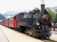
The Ziller Valley is 35 km long, but reaching one of the many towns and ski resorts in the valley is convenient by Zillertalbahn (Ziller Valley Railway). This narrow gauge railway has its terminus station in Jenbach, making transfer from Austrian Rail to Zillertalbahn easy. Trains on the Zillertalbahn depart every 30 minutes from Jenbach to Mayrhofen, stopping at nearly every major town along the way.
The Zillertalbahn is privately owned and operated, so separate tickets must be purchased. In winter, use of the Zillertalbahn is free if you can be identified as skier (regardless whether you have a ski pass or not).
The Achenseebahn also terminates in Jenbach, so transfers from Achenseebahn to Zillertalbahn are also possible. Unlike the Zillertalbahn however, it's Achensee counterpart doesn't operate during winter months.
Get around
The most comfortable and fastest way to get around is by Zillertalbahn, which travels between 1 Jenbach station ![]() and 2 Mayrhofen station with half hour intervals. It has stops in Rotholz in the Lower Inn Valley, 3 Strass im Zillertal, 4 Schlitters/Bruck am Ziller, 5 Gagering, 6 Fügen/Hart im Zillertal, 7 Kapfing im Zillertal, 8 Uderns/Finsing, 9 Ried im Zillertal, 10 Kaltenbach/Stumm, 11 Angererbach, 12 Aschau, 13 Erlach, 14 Zell am Ziller, 15 Laimach Regionalmuseum, 16 Ramsau/Hippach (get off here for Schwendau), and 17 Bichl.
and 2 Mayrhofen station with half hour intervals. It has stops in Rotholz in the Lower Inn Valley, 3 Strass im Zillertal, 4 Schlitters/Bruck am Ziller, 5 Gagering, 6 Fügen/Hart im Zillertal, 7 Kapfing im Zillertal, 8 Uderns/Finsing, 9 Ried im Zillertal, 10 Kaltenbach/Stumm, 11 Angererbach, 12 Aschau, 13 Erlach, 14 Zell am Ziller, 15 Laimach Regionalmuseum, 16 Ramsau/Hippach (get off here for Schwendau), and 17 Bichl.
Use of the Zillertalbahn in winter is free if you're wearing a winter sports attire.
See
Do
The Ziller Valley is one of the pioneering areas for winter sports, and the first Penkenbahn was opened in 1954. The valley boasts over 670 km of groomed slopes, making it one of the largest winter sports destinations in Europe.
Eat

The local specialty is Zillertaler Krapfen, fried pasties with a cheese and herb filling.
Another specialty is the Zillertaler Graukäse, a traditional, cold-matured sour milk cheese made from the hay milk (raw skimmed milk). It is matured over 6-8 weeks and develops a blue-green mold on the outside. The cheese has a hearty, spicy, and rustic taste. It is made at the 1 Heumilch dairy in Fügen and is served in many restaurants in the Ziller Valley.
Drink
A local specialty is apricot liquor (German: Marillenschnaps) made at the 1 Stiegenhaushof distillery in Schwendau, where the production process can be visited with guided tours.
Stay safe
- See also: snow safety
Go next
- Tuxer Valley — a side valley of the Ziller Valley to the west
- Finkenberg — ski resort
- Hintertux — home to a large glacier known as the Frozen Wall (German: Gefrorene Wand) on which skiing is possible year round
- Gerlos — ski resort in a mountain pass between Tyrol and Salzburg
- Lower Inn Valley — economic heart of Tyrol with the majestic Inn river
- Innsbruck — the regional capital and only major city in the Alps
- Wattens — known for the famous Crystal Worlds
- Hall in Tirol — famous for its ancient salt mines
- Achen Valley — beautiful valley around the Achen Lake