 | ||
| Leutasch | ||
| federal state | Tyrol | |
|---|---|---|
| Residents | 2.380 (2018) | |
| height | 1,136 m | |
| Tourist info | 43 (0)5214 6205 Olympiaregion Seefeld | |
| no tourist info on Wikidata: | ||
| location | ||
| ||

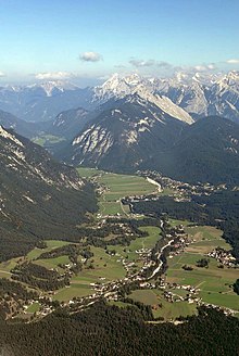
Leutasch is a resort in Tyrol. The mountain village with 24 hamlets is located on the Seefeld plateau embedded between Wetterstein, Karwendel and Mieming Mountains. In winter, the valley at an altitude of 1150 m is transformed into a popular cross-country skiing arena. In summer there are attractive walking and hiking opportunities. The valley is marketed for tourism as part of the "Olympiaregion Seefeld".
background
There are no prehistoric finds in the area of the municipality of Leutasch, the first documentary mention is a deed of donation from 1178 which records a forest with the Luitaske river.
Since its inception, Leutasch has always been a region strongly influenced by agriculture and forestry, it was only with the development of traffic engineering that tourism emerged as a further branch of business.
Until the secularization in 1803 Leutasch belonged to the Augustinian Canons of Polling Weilheim and then arrives at the land Tyrol.
The place itself is located in an almost twenty kilometers long, protected high valley between the mountains of the Wetterstein, Mieming Mountains and the Arnspitze, a single mountain, which is still counted as part of the Wetterstein Mountains.
Leutasch consists of the following 24 districts, whereby the Leutasch district itself does not exist: Weidach, Seewald, Föhrenwald, Emmat, Gasse, Kirchplatzl, Aue, Platzl, Wiesensiedlung, Plaik, Klamm, Obern, Moos, Ostbach, Neuleutasch, Unterkelle, Lehner , Ahrn, Puitbach, Reindlau, Lochlehn, Unterkirchen, Burggraben, Schanz. The districts, hamlets and farmsteads are spread over almost the entire length in the high valley of Leutasch.
Neighboring municipalities in Tyrolean Oberland are Wildermieming, Telfs, Seefeld in Tyrol and Scharnitz. Neighboring municipality in Werdenfelser Land (Upper Bavaria) is Mittenwald
getting there
| Distances (road km) | |
| Seefeld | 9 km |
|---|---|
| Scharnitz | 13 km |
| Mittenwald | 15 km |
| Garmisch | 37 km |
| innsbruck | 32 km |
| burner | 64 km |
| Munich | 125 km |
| Salzburg | 206 km |
| Vienna | 506 km |
By plane
The nearest international airports are in innsbruck (Distance about 30 km) and north of Munich the Munich Airport (also "Franz Josef Strauss", distance approx. 147 km)
By train
The next train stations are in Seefeld and Mittenwald, they are available at the Karwendelbahn Munich above Garmisch-Partenkirchen and Mittenwald to innsbruck.
It is especially useful to arrive via the Seefeld train station. Here, among other things, even a pair of ICE trains on the Hamburg - Munich - Garmisch-Partenkirchen - Innsbruck connection. There is a sufficient number of buses from Seefeld train station to the Leutscher Tal (lines 430 and 431).
From Mittenwald train station, there is only a limited bus service to Leutasch on line 431.
If you arrive by bus & train and spend the night in a holiday apartment, it is best to choose your accommodation in Weidach. The only larger food market in the valley can be found here. There is also an information office for the "Olympiaregion Seefeld" here. Several ski rentals (including a ski school) and the Alpenbad can be found here within walking distance. There is also the for mobility in the valley "Leuscher village bus", which opens up the entire valley as a ring line. The central bus stop in Weidach is the "Weidach Zentrum" bus stop (1 ).
In the street
Of north (Munich area) via the A 96 towards Garmisch-Partenkirchen and continue on the B2 to Mittenwald. In the Mittenwald branch to Leutasch.
Of south (Innsbruck area) via the federal highway 177 from the Lower Inn Valley (Zirl) and via Seefeld to Leutasch.
mobility

The place itself is extremely spacious, the individual hamlets are all more or less far away along the local thoroughfare L14.
Public transport
The operator of the regional bus routes is the Verkehrsverbund Tirol:
- Line 430: Seefeld train station - Weidach - southern Leutascher Tal (endpoints of the line vary depending on the journey)
- Line 431: Mittenwald-Bahnhof - northern Leutascher Tal - Weidach - Seefeld-Bahnhof (the German section of the line between the Geisterklamm stop and Mittenwald Bhf cannot be used with the all-inclusive bus ticket for the Olympiaregion Seefeld).
- The Leutasch village bus also runs in the valley (as a circular route throughout the valley).
With a guest card you can get a flat-rate bus ticket for the duration of your entire stay at the information office for € 12. It applies to the entire "Olympiaregion Seefeld". The bus ticket is already included in the multi-day cross-country ski trail ticket for the Olympiaregion for € 15. It is also valid for the duration of the entire stay according to the guest card. A hard copy of the timetable for the "Olympiaregion Seefeld" is available from the information offices. Timetables can be downloaded from www.seefeld.com.
The line network with stops can be displayed in the interactive map above under "Levels" -> "Transport line network".
Alpine ski users are even transported free of charge on the bus network (excluding Mittenwald) on the way to the gondola. According to the introduction in the timetable booklet, it is necessary to carry alpine ski equipment or a valid ski pass (as of 01-2019).
Parking spaces
- 2 Car park bridge / Alpenbad. The large square (including buses) can also be used in winter. There is a public toilet. This is freely accessible. Direct access to four trails.Price: Car up to 2 hours: € 2, car day ticket: € 4; Buses: flat-rate day ticket € 15.
- 3 Cross-country ski trail parking lot at the "Gasse" district (seasonal in winter). Located directly on the country road, south of the village entrance from Gasse. Cross-country ski trail connection.Price: chargeable.
- 4 Cross-country ski trail parking lot "P5 - Weidach" (seasonal in winter). Location directly on the country road, western entrance to Weidach (north of the road). Cross-country ski trail connection.Price: chargeable.
- 5 Parking lot "P5 - Weidach" (here all year round). Location directly on the country road, western entrance to Weidach (west of the street). Cross-country ski trail connection.Price: chargeable.
- 6 "Rödlach" car park (all year round). bigger space. Location near the road south of the Ostlach district. Public toilet available. Connection to several cross-country trails (including an easy A5 route).Price: chargeable.
Tourist Attractions
- 1 Parish Church of St. Mary Magdalene. The first church in the village was built in 1190, the current building was rebuilt in 1820-21 and consecrated in 1831. Inside, the ceiling painting and the high altar painting are worth seeing, they are by Leopold Puellacher. One of the four bells in the tower bears the year 1482.

- Parish church St. John the Baptist in Unterkirchen (Unterleutasch) from 1831.
- There are a total of 18 throughout the local area Chapels.

- There are a number of examples in town for Lüftlmalerei.
- 2 Leutascher Geisterklamm (parking lot). The gorge is located at the northern end of the valley near Mittenwald. There is an almost three-kilometer circular route with an 800-meter-long section as a spectacular metal path through the Leutasch Gorge, which is up to 75 meters deep. Refreshments ("Klammstüberl") at the paid parking lot (geo-coordinate points to the parking lot). Bus stop "Geisterklamm" of line 431 (Seefeld Bhf - Weidach - Mittenwald Bhf) directly at the car park entrance.Open: The route is open in the summer months.Price: The Klammweg is accessible free of charge.

- 3 Ganghofer Museum (Museum on the life and work of the poet, museum on the history of the village), Kirchplatzl 154, 6105 Leutasch. Tel.: 43 (0)5214 20093. From 1897 Ganghofer had his summer and hunting lodge in the Gaistal on the Tillfußalm, he named it "Schloss Hubertus" after his famous novel. The house can be "approached" from the north via the "C1" trail. As far as the museum, the C1 trail is level and therefore easy to negotiate.Open: Tue and Wed 10 a.m. to 12 p.m., Thu and Fri 4 p.m. to 6 p.m.Price: 3.- € (with guest card 2.50 €), children up to 14 years free.

- 4 Porta Claudia (Leutascher Schanz). The former fortification is located on the Scharnitz Pass as a dam at the narrow point in the north-facing valley access. The complex was built in 1633 during the Thirty Years' War under Claudia de Medici, Archduchess of Austria and duchess and eponymous for the defense system. The fortification served to monitor the transition from Bavaria to Tyrol, which was important at the time, and in 1670 the facility was expanded again. From 1805 she was involved in military actions in the Napoleonic Wars between Bavaria and Austria, see below at Franzosensteig. Remnants of the wall are still preserved today.Open: freely accessible.

- Weidachsee - Fishing pond (see section "Activities"), which is surrounded by coniferous forest. There are walking paths around the water.
- 5 Ski bench. The bench with cross-country skis can be found at Plaik.Open: freely accessible.

Gaistal

The rugged high mountain valley with numerous huts and alpine pastures invites you to go hiking and MTB tours. The mountain lakes in the valley near Ehrwald are beautiful destinations (from Leutasch it is more of a destination for a MTB tour, as it is quite a long route for day hikes - see below for more). As of 01-2019, it is unclear in which the gravel path is also suitable for touring pedelecs.
- 7 "Salzbach" car park. Up to here the Gaistal can be traveled by car. From the "Salzbach" car park, you can only continue on foot or by bike. There is a public toilet in the parking lot.Price: chargeable.
- 8 Parking lot "Salzbach - P 4". Price: chargeable.
- 9 Parking lot "Stupfer". Price: chargeable.
How to get there by public transport:
- 10 Stop "Gaistal / Saltzbach". The Leutasch village bus goes up to here into the valley. The line 430 from Seefeld does not stop at this stop, however.
- 11 Stop "Klamm". Next stop of line 430 (from / to Seefeld) to Gaistal. The Leutasch village bus also stops here.
By the way, near the stop "Klamm" can be found at 12 a electronic information with panorama map of the Gaistal from summer. The hiking trails are shown. There is also a list of mountain huts and alpine pastures with electronic opening indicators. The information also contains a computer terminal with further tourist information.

By bicycle: The Gaistal is accessible by bike. From Oberleutasch (around 1150 m) the gravel valley path climbs mostly leisurely to around 1600 m before Ehrwald. Some alpine pastures are accessible by bike via roadways.
A nice touring destination by mountain bike or touring bike (profile for sometimes coarser gravel roads and mountain-suitable gearshifts are important) is that 6 Seeebensee at 1657 m. Gravel roads lead directly to the lake. From Weidach it is about 20 km easy. There is a possibility to stop for a break on the Seeebenalmwhich can be found on the road to the water.

activities
- 1 Alpenbad Leutasch (Sauna area, solarium, tennis and squash), Weidach 275, A-6105 Leutasch. Tel.: 43 (0)5214 6380. Restaurant at the bathroom.Open: in the 2018/19 winter season daily 10 a.m.-10 p.m., other opening times (such as the sauna area) see website.
- 7 Weidachsee (Fishing pond, 1,130 m, Leutasch fishery) (at the district Weidach in the middle valley floor of Leutasch). Tel.: 43 (0)5214 6141. 4.5 hectares of fishing pond used by the Leutasch fishermen. Fishing rentals, fishing courses, no fishing license required. Ice fishing on request. There are trout and char for fishing. The lake can be hiked around.Open: April to Nov.

hike

In the Leutascher Tal there are various hiking possibilities - from the simple, level valley path along the Leutascher Ache to the demanding high mountain path.
Walks and short hikes
- 2 Walk to the crank slope viewpoint. From the center of Weidach you can take a one-hour walk to the crank slope viewpoint. The 2.5 to 3 km long loop leads up to a small wooden platform in the forest as a forest path over about 250 meters in altitude. A bank invites you to linger here. A further north-west view opens up over the valley and over to the Wetterstein Mountains.
Hikes to managed mountain huts and alpine pastures
There are various options for attractive day and half-day tours. Often you can choose between a mountain hiking trail and a driveway for the ascent. It is advisable to choose the shorter but mostly steeper variant of the hiking trail uphill. Downhill, however, steep paths are "more on your knees". For the descent it therefore makes, if possible, to choose the route. Depending on the gradient of the path, you can take the mostly longer route downhill "at a march". Hiking sticks are of course always a good help. In any case, it is important to have at least halfway sturdy, ankle-high shoes with non-slip treaded soles. List of huts see section Alpine pastures and mountain huts.
further hiking tours
- Franzosensteig: In the 3rd coalition war under Napoleon, the Allied Bavarians were able to use this route from Mittenwald and over the Lautersee, Ferchensee and the Grünkopf (1,587 m) past the military dam of the Porta Claudia bypassing and stabbing the Austrians in the back on November 4, 1805, decisive for the war. Then the fortifications in Scharnitz also fell; on December 26, 1805, Austria had to surrender the counties of Tyrol and Vorarlberg to Bavaria.
- The Franzosensteig is now a designated hiking route to Mittenwald, starting from the main road near Porta Claudia.
Winter sports
Cross-country skiing

In the wide valley floor, an extensive network of trails is groomed in front of an impressive high mountain panorama. In the valley there are several easy, largely flat cross-country trails that can be linked. If you want to complete all the easy trails along the length of the valley floor (A5, A6, A7 and A9) on a sporty day tour, you will get around 30 km. Unless otherwise stated, the following trails are combined routes for classic style and skating. The routes are designed as circular routes in one-way traffic. Signs on site indicate the direction of travel at most boarding points. Otherwise you usually drive counter-clockwise.
- Line fee: Day ticket € 10 (with guest card: € 5). Multi-day ticket with guest card for the duration of the stay: flat rate € 15 (as of 01-2019). The multi-day ticket includes a bus ticket for the Olympiaregion Seefeld. The cross-country ski trail tickets can be booked on the guest card in the tourist offices of the Olympiaregion Seefeld.
- Trail map: the extensive range of routes can be found on the "Olympiaregion Seefeld" trail map. This folding map is available free of charge from the tourist offices. The most important cross-country trails from this map, which are located in the valley floor, are listed below. From Moos there is a connection to Seefeld via medium to difficult trails (demanding day tour - for this route offer see trail map or here on www.seefeld.com).
- 3 Leutasch ski school, Weidach 275b, 6105 Leutasch. Tel.: 43(0)5214 6762. For example, if you want to learn the skating technique, this is the place for you. There is also a ski rental. Location at the Alpenbad. There are also practice trails here.Open: during the season: ski school office and rental daily 9 a.m. - 5 p.m.
- List of ski rentals see also section "Ski and bike rental"
- Arrival by bus from Seefeld: For a cross-country excursion from Seefeld, you can reach the valley with the 430 bus, which starts in Seefeld at the train station. The best place to take the bus in Leutsch is at the "Alpenbad / Brücke" stop. 13 leave. There are entry points to four cross-country trails here.
Easy trails (A in blue marking): The easy trails are geographically arranged from south to north. The cross-country trails A5, A6, A7 and A9 can be combined counter-clockwise to a sporty day tour with a length of around 30 km in the valley floor.
- 4 "Obern" trail (A5) - The 5.3 km long circular trail can be accessed at the "Rödlach" car park (location of the geocoordinate). The "Rödlach / Parking Lot" bus stop is also located here. The stop is approached by the Leutasch village bus and line 430 from Seefeld. In the northern part of the route there is a ski underpass under the country road and a connection to the "Alpenbad" trail (A6). Route on Openstreetmap.

- 5 "Alpenbad" trail (A6) - The 5.6 km long circular trail starts at the (trail) parking lot opposite the Alpenbad. There is also a public toilet here. The 430 line from Seefeld also stops here at the "Alpenbad / Brücke" bus stop. The trail itself is classified as easy. However, it contains a more challenging hill between the Alpenbad and the "Kirchplatzl" junction. Especially in the direction of travel north towards Alpenbad, it goes steeply downhill with a curve (but a spacious bend area). For this descent you should be reasonably confident with the snow plow. The hill descent is also quite fast in the south direction. If you are reasonably secure on your skis in the classic style, you can stay on track here and "let it go". At 14 Incidentally, in January 2019 there were four "winter benches" near the trail. These were relatively sheltered from the wind on the south side in front of conifers and were a nice place to take a break. There are also two places to stop for refreshments in the area of the route: The small Aumoosalm is located directly on the route. The "Hubert's Stüberl" inn can be reached via a short, signposted branch trail. Route on Openstreetmap.

- 6 "Gasse" trail (A7) - The easy, 4.7 km long loop trail Gasse can be described as the "central" trail in the valley floor. She is one of the most popular. It has several entry points (with parking spaces) and can also be completed in partial rounds. The geocoordinate points to the entrance near the parking lot or bus stop at the "Alpenbad" bridge. Route on Openstreetmap.

- 7 Loipe Lehner "(A8) - The easy 1.8 km long circular trail branches off at the geographic coordinate of the "Unterleutasch" valley trail. If there is already a lot of activity on the Gasse cross-country ski trail (A7), it is usually even emptier up here on the slightly elevated loop. At 15 In 01-2019 there were two "winter benches" near the cross-country ski trail on the winter hiking trail. These stand in the south, sheltered from the wind, in front of a few conifers. In the sun you can relax here (there is also a small, slightly elevated valley view). Route on Openstreetmap.
- 8 Unterleutasch trail "(A9) - The flat, 13.7 km long circular trail starts at the hamlet "Ahrn". The route opens up the northern valley floor and can be shortened. The bus line 431 (Seefeld Bhf - Weidach - northern Leutscher Tal - Mittenwald Bhf (for the location of the stops, see the printed trail map) also runs parallel to the Landstrasse. The local village bus of the Leutasch Valley also runs here. Route on Openstreetmap.
- 9 "Weidach" trail (A10) - The flat, 1.7 km long circular trail also starts at the (trail) parking lot opposite the Alpenbad. In principle, the route leads over the "village meadow" of Weidach. A counter-clockwise circuit can also be completed here. Route on Openstreetmap.
Medium trails (B in red marking):
- 10 Waldloipe trail (B11) - The hilly, 2.7 km long cross-country trail branches off from the A6 "Alpenbad" trail at the geocoordinate near the hamlet "Ostbach". In the north direction it runs through the forest to above the Alpenbad. Here it joins the A6 on the steep hill. Using the A6 route in the "south" direction, a round course of around 5 km in length is possible. Route on Openstreetmap.
Difficult trails (C in black marking):
- 11 "Plaik" trail (C9) - The 8.7 km long circular trail, classified as difficult, starts at the parking lot / bus stop at the "Alpenbad" bridge. As far as Kirchplatzl, it is completely flat and therefore easy (connection to the Ganghofermuseum). Then it's hilly through the forest up to a sun terrace above the Plaik district. At the entrance (location of the geocoordinate) you can change directly to the "Gasse" trail (A7). There are also connections to the A6 and A10 routes within walking distance. In principle, there is also a narrow ski underpass with oncoming traffic (!) Under the country road to the A6 trail. With snow depths of 1.2 to 1.3 m, this was not in operation in January 2019.
Winter hiking

In the wide valley floor, among other things, an extensive network of winter hiking trails is being cleared. The routes can be found on the winter hiking map of the "Olympiaregion Seefeld". This folding map is available free of charge from the tourist offices.
Some mountain huts and alpine pastures that are managed in winter can also be reached on foot: These are the Rauthhütte (1600 m), Wettersteinhütte (1717 m). Gaistalalm (1379 m), Hämmermoosalm (1417 m) and the small Hochmoos-Alm (around 1360 m, formerly Katzsteinhütte) directly at the mountain station of the 3-seater chairlift "Kreithlifte".
Sledding
There are several natural toboggan runs in the valley. These are included in the winter sports card, which is available from the tourist information.
- Hochmoos-Alm toboggan run - The approximately 2 km long route runs parallel to the "Kreithlifte" chairlift. The chairlift can be used for the ascent (hourly ticket in 01-2019: 1 h -> 13 €, 2 h -> 17 €). Depending on the toboggan activity, you can toboggan five to seven times in two hours. The sled is hung on hooks on the armchair by the staff. Toboggan rental downstairs in the ski rental opposite the valley station (in 01-2019 one day € 5). Attention: the route is also used by pedestrians. The toboggan run has a sliding point at the crossover of the ski slope. Furthermore, depending on the nature of the snow, there are some places where you may come to a standstill as a single rider on the sled. The challenge here is to take the easier corners in front of these flatter spots with as little braking as possible. Tip for single riders: The best way to steer the sledge is to shift your body weight to the side behind the sled's center of gravity. As a single rider, this works quite well indirectly: Lean back with your upper body into the tensioned pull rope of the sled (behind the center of gravity). Then, depending on the curve, simply swivel the upper body to the side a little (indirect steering method: e.g. upper body to the right and back out-> slide moves to the left). For "hard turns", however, you usually also have to use the direct "leg steering technique": z. B. left leg out to brake: the carriage moves to the left. If you sit on a toboggan here on the "Hochmoos-Alm" toboggan run, you can usually get over the flatter areas better. Route on Openstreetmap.
- Rauthhütte toboggan run - The road to the hut with a length of 2.5 km and 400 meters in altitude is also used as a toboggan run. Route is also used by pedestrians. Ascent time about 90 minutes. Route on Openstreetmap.
- Hämmermoosalm toboggan run - The road to the hut serves as an easy, family-friendly natural toboggan run.
- Wettersteinhütte toboggan run - The access to the hut with a height difference of 550 m also serves as a demanding natural toboggan run.
Alpine skiing
Compared to other places in Tyrol, alpine skiing plays a subordinate role in Leutasch. However, there are also options here:
- 12 "Kreithlifte" ski area: valley station of the 3-seater chairlift). Height about 1150 to 1350 m. Slope length up to about 2 km. Note: The small ski area probably doesn't have its own website.Price: single chairlift ride: € 9, season tickets for skiing and tobogganing: 1 hour: € 13, 2 hours: € 17, day ticket: € 32.
- 13 Ski tour descent at the Rauthhütte. The single chairlift ("Mundelift") that once existed here has been dismantled since 2003. The route (about 2 km with an altitude difference of 400 meters) is even leveled with a snowcat. It also serves as an ascent route for the snowshoe tour "Moos - Krauthhütte - Buchen" (see also winter hiking map in paper of the Olympiaregion Seefeld). Arrival by car until 16 Rauthhütte car park. Refreshments can also be made directly at the car park (Mundestadl).Price: chargeable.
Snowshoeing
Route suggestions for snowshoe tours can be found on the winter hiking map of the "Olympiaregion Seefeld". This folding map is available free of charge from the tourist offices. A snowshoe tour, for example, leads up the ski tour descent to the Rauthhütte and on the southern slope over a mountain hiking path to Buchen.
shop
There are several bakeries and grocery stores spread across the valley.
Grocery markets and shops
- 1 "MPREIS" supermarket, Weidach 340, 6105 Leutasch. Larger food market in the "Weidach" district.Open: Mon-Fri 7:30 am-7pm, Sat 7:30 am-6pm.

- 2 Gohm supermarket (Eva-Maria Gohm), Obern 34A, 6105 Leutasch. Tel.: 43 (0)5214 6179. small grocery store in the district of "Obern".Open: Mo-Fr 8-12 and 14: 30-18, Sa 8-12 and 15-17, Su 10-12.
- 3 Leutasch farm shop, Kirchplatzl 131, 6105 Leutasch. Tel.: 43 (0)5214 6128. Local farm products, products from farm handicrafts.
Ski and bike rental
- 4 Sport Norz, Weidach 318c, 6105 Leutasch. Tel.: 43 (0)5214 6103. Distribution: i.a. Nordic skiing, snowshoes and tobogganing. E-bike rental in summer.
- 5 Sport Wedl, Weidach 322 g, 6105 Leutasch. Tel.: 43(0)5214 6444. Rental, among others Nordic and alpine skiing, snowshoes, tobogganing. E-bike rental in summer.
- 6 "Sportalm" ski rental, Kreith 381 c, 6105 Leutasch. Tel.: 43(0)5214 6375. Located opposite the Kreithlifte valley station: Rental: a.o. Alpine skiing, Nordic skiing and tobogganing.
kitchen
- 1 Trout farm (Fish specialties), Am Weidachsee, A-6105 Leutasch / Tyrol. Tel.: 43 (0)5214 6455.
- 2 Inn to the mill (Inn, regional game specialties, rooms), Burggraben 264, A-6105 Leutasch / Tyrol (in the north of the valley directly on the valley road to Mittenwald). Tel.: 43 (0)5214 6712.
- 3 Aumoosalm, Aue 123 a, 6105 Leutasch. Refreshments with a smaller menu. The rustic wooden hut is located directly on the easy trail "Alpenbad" (A6) and on the (winter) hiking trail along the Leutascher Ache.
- 4 Hubert's parlor. The inn in the hamlet "Aue" can be reached from the "Alpenbad (A6)" trail via a short, signposted branch trail. There is also an ice rink at the restaurant.
- 5 Muggenmoosalm. Nice walking destination located south of Moos. Also accessible via cross-country trails in winter.
- 6 Il Tartufo (Italian restaurant & pizzeria), Weidach 318, 6105 Leutasch. Mobile: 43 664 230 5580.
- 7 Poli's hut. Smaller, German-Austrian menu (including cakes and desserts), sunny terrace with deck chairs (blankets in winter). Accessible directly from Loipe Gasse (A7).
- 8 Mundestadl (Pub / small restaurant), Moos 7a, 6105 Leutasch. Tel.: 43(0)5214 20008. Located directly at the "Rauthhütte" car park (in winter the toboggan run and ski tour descent to the Rauthhütte start here).
- 9 Gasthof Zur Brücke (Closed Tues & Wed), Burggraben 257, 6105 Leutasch. Tel.: 43(0)5214 6930. further phone alternatively according to website: 43 (0) 5214 6275.
- 10 Küthaierhof, Kirchplatzl 139, 6105 Leutasch.
Alpine pastures and mountain huts
The following is a list of the managed alpine pastures and mountain huts in the area of the municipality of Leutasch. The huts are a great destination for day hikes or MTB tours. Many of the huts are within walking distance even in winter. Some of the track is then also used as a natural toboggan run.
- 11 Rotmoosalm (2030 m, no overnight stay). Approach from the "Salzbach" car park in the Gaistal (1240 m, public toilet, stop of the Leutsch village bus in summer at the P4 car park just below) in a good two hours via mountain hiking trails. Via the Gaistalalm it can also be reached in about 2 1/2 hours via roadways (MTB route).Open: open from mid-May to mid-October.
- 12 Wankalm (1751 m). Tel.: 43 (0)664 9196073. Overnight accommodation in room and warehouse (reservation by phone). Location directly above the Wettersteinhütte.Open: open in summer from mid-May.
- 13 Wettersteinhütte (1717 m). Mobile: 43 (0)660 3462100, 43 (0)664 8958227, Email: [email protected]. Mondays are closed in winter. Overnight stay (35 beds) only possible after prior reservation. In winter, access is possible via the road that also serves as a natural toboggan run (around 550 meters in altitude with 90 minutes to a maximum of 2 hours of walking from the Klamm district) Panoramic views of the valley and over to the Hohe Munde.Open: also open in winter, closed on Mondays in winter.Accepted payment methods: cash only.

- 14 Rauthhütte (1600 m). Mobile: 43 (0)664 281 5611. Ascent from the "Rauthhütte" car park near Moos in about 60 to 90 minutes. The 3 km long track (400 meters in altitude) is also used as a natural toboggan run in winter. There is also a ski tour run from the hut. From the house panorama view u. into the Leutasch valley and over to the Karwendel. Overnight accommodation: mattress dormitories and rooms.Open: also open in winter.
- 15 Hämmermoosalm (1417 m). Mobile: 43 676 333 7 000. Overnight accommodation for up to 25 people, ascent from the "Salzbach" car park in about 30 to 45 minutes, depending on the route chosen. In winter, the track also serves as a groomed natural toboggan run (easy, family-friendly route).Open: also open in winter.

- 16 Gaistalalm (1379 m). Tel.: 43(0)5214 5190. Zustieg vom Parkplatz "Salzbach" auf 1240 m (gebührenpflichtig, öffentliches WC vorhanden) in etwa 1 1/2 über den geschotterten Fahrweg in Tallage (auch Winterwanderweg und im Sommer Radstrecke). Zu Fuß kann im Sommer auch der Ganghoferweg im nördlichen Talhang genutzt werden (ist für Fahrräder gesperrt). Im Sommer auch Übernachtungsmöglichkeit (Lager für 15 Personen, telefonische Reservierung ist notwendig).Geöffnet: auch im Winter bewirtschaftet.
- 17 Hochmoos-Alm (1360 m, ehem. Katzsteinhütte). Die kleine Hütte (keine Übernachtungsmöglichkeit) liegt direkt an der Bergstation der 3er-Sesselbahn "Kreithlifte". Mit Stand Januar 2019 ist Mittwoch Ruhetag. Schöner Panoramablick im das Leutascher Tal sowie hinüber zum Wettersteingebirge und zur Hohen Munde. Im Winter zur Fuß von Weidach über planierte Fahrwege erreichbar. Diese Wege dienen auch als Naturrodelbahn parallel zur Sesselbahn. Aus Richtung Seefeld bzw. aus dem Bereich Wildsee ist die Hochmoos-Alm auch über eine schwere, klassische Loipe erreichbar.
- 18 Tillfussalm (1420 m). Alm in Tallage mit Biergarten und Spielplatz. Gehzeit vom Parkplatz "Salzbach" rund 75 Minuten. Nah der Alm findet sich das ehemalige Jagdhaus des Schriftstellers Ludwig Ganghofer. Der Bau ist nicht zugänglich. Das Ganghofermuseum im Ortsteil Kirchplatzl informiert aber zum Thema (siehe Abschnitt Sehenswürdigkeiten).
nightlife
In Leutasch wird es am Abend außerhalb der Gastronomiebetriebe recht ruhig, nahe Ortschaften mit etwas mehr an abendlicher Unterhaltung sind Seefeld and Mittenwald oder gleich nach Innsbruck.
accommodation
Die Statistik gibt für Leutasch gut 5000 Gästebetten an. Grober Hinweis zu den Abschnitten "Günstig", "Mittel" und "Gehoben": Bezug auf Winterspreis für Doppelzimmer/Appartment inkl. Frühstück pro Nacht (für 2 Pers.). Günstig: max. bis 80 €, Mittel: 80 - 150 €, Gehoben: oberhalb 150 €
Allgemein: Unterkunftssuche beim Tourismusverband unter booking.seefeld.com (Ortssuche Filter Leutasch).
Cheap
- 1 TIROL.CAMP Leutasch, Reindlau 230b, 6105 Leutasch. Tel.: 43(0)5214 65 70-0. Anfahrt öffentlicher Verkehr: Bushalt "Reindlau" der Linie 431 (Seefeld Bhf - Weidach - Mittenwald Bhf) nah am Platz.
- 2 Pension Holzmann, Ostbach 8, 6105 Leutasch. Tel.: 43 (0)5214 6449. Merkmal: Pension.
- 3 Gästehaus Kluckner, Weidach 363c, 6105 Leutasch. Tel.: 43(0)5214 6670. Merkmal: Pension.
medium
- 4 Biolandpension Monika, Weidach 347, 6105 Leutasch. Tel.: 43(0)5214 6288. Merkmal: Pension.
Upscale
- 5 Hotel Kristall * * * *, Weidach 300 m A-6105 Leutasch - Tirol. Tel.: 43 (0)5214 6319, E-Mail: [email protected].
- 6 Biohotel Leutascherhof * * * *, Weidach 305, A-6105 Leutasch - Tirol. Tel.: 43 (0)5214 6208, Fax: 43 (0)5214 6978, E-Mail: [email protected].
health
- 1 Praktischer Arzt / Hausapotheke Dr. Oswald Heis, Weidach 293a, A-6105 Leutasch. Tel.: 43 (0)5214 6910.
| Kurzinfos | |
| surface | 103,1 km² |
|---|---|
| Telefonvorwahl | 05214 |
| Postleitzahl | 6105 |
| Kennzeichen | IL |
| Zeitzone | UTC 1 |
| Notruf Polizei | 133 |
| Feuerwehr | 122 |
| Rettung | 144 |
| Bergrettung | 140 |
Practical advice
Touristinformation
- Tourist Info Olympiaregion Seefeld (Allgemein Olympiaregion Seefeld), Klosterstr. 43, A-6100 Seefeld. Tel.: 43 (0)5 08800, Fax: 43 (0)5 0880-51, E-Mail: [email protected].
- 2 Informationsbüro Leutasch (Lokal im Tal), Weidach 320, 6105 Leutasch. Tel.: 43(0) 50880510, E-Mail: [email protected]. Geöffnet: wechselnd je nach Saison.
- Kurtaxe - Die Kurtaxe beträgt 2,80 € (Stand 01-2019).
Öffentliche Toiletten
- 3 Toilette Weidach am Musikpavillon
- 4 Toilette am Parkplatz "Brücke / Alpenbad". Preis: frei zugänglich.
- 5 Toilette Kirchplatzl. Preis: frei zugänglich.
- 6 Toilette am Parkplatz "Rödlach"
- 7 Toilette am Parkplatz "Salzbach"

trips
- In die umgebende Bergwelt von Mieminger Bergen, Wetterstein and Karwendel, Scharnitz als er Ausgangspunkt für Touren in die Karwendeltäler ist schnell zu erreichen.
- Innsbruck, Doppel-Olympiaort und Landeshauptstadt von Tirol ist ebenfalls leicht zu erreichen
- Mittenwald, mit zahlreichen Lüftlmalereien und mehreren Badeseen
- Garmisch-Partenkirchen, Olympiaort mit malerischer Innenstadt
literature
Web links
- http://www.leutasch.at/ – Offizielle Webseite von Leutasch
- Olympiaregion Seefeld - offiziell (zur Touristikregion gehören Leutasch, Mösern, Reith bei Seefeld, Seefeld und Scharnitz)