
The Karwendel or Karwendel Mountains belong to the northern chain of the Limestone Alps and are located in North Tyrol (Austria) and Upper Bavaria (Germany). The rugged mountain range is protected by the Karwendel Alpine Park.
Regions
| location | ||
| ||

The Karwendel covers an area of approx. 800 km². Around 80% of them are on Tyrolean Reason, of which the largest share in turn goes to the municipality of Vomp, district black not applicable, the rest of the Karwendel belongs to Upper Bavaria.
According to the topography, the Karwendel is deeply cut Valleys divided into several subgroups.
- The Karwendel main chain (also the Hinterautal-Vomper chain) as the central part of the mountain;
- The Northern Karwendel range is the sub-region northwest of the main ridge;
- The Falcon group adjoins the northern Karwendel range immediately to the east.
- The Sonnjoch Group is a single mountain ridge on the Achensee;
- The Gamsjoch group is a smaller subgroup north of the main chain and between the Falken and Sonnjoch groups.
- The Gleirsch-Halltal chain is the sub-region southwest of the main ridge;
- The Internal chain is the southernmost part of the mountain near Innsbruck;
- The Soierngruppe is the smallest subgroup in the northwest of the Karwendel;
- The Vorkarwendel With the Karwendel nature reserve, the mountains are immediately northeast of the Riss valley and in the very northeast of the mountains.
places
The Karwendel Mountains themselves are only sparsely populated, there are no real villages here, just a few smaller hamlets and alpine pastures. The larger settlements are all located on the edge of the mountains, the largest settlement area is the Inn Valley to the south.
in North Tyrol

in the Tyrolean Lower Inn Valley south of the Karwendel:
- Vomp (563 m) - holiday resort in the Inn Valley. Large parts of the Karwendel belong to Vomp, including the hamlet that is only accessible from Germany Rear crack and the Almdorf Eng.
- Terfens (591 m) - small town in the Inn Valley, part of the Karwendel Alpine Park;
- Stans (Tyrol) (563 m) - mountain village at the foot of the Karwendel, Wolfsklamm in the Karwendel is particularly popular here;
- black - Located in the Inn Valley, worth seeing include Tratzberg Castle and the silver mine. Beautiful historic old town;
- Hall in Tirol (574 m) - historical city;
- innsbruck (600 m) - Alpine metropolis and international center for tourism and winter sports in the Inn Valley;
- Zirl (622 m), market town
in the west of the Karwendel:
- Scharnitz (954 m) - border town and winter sports area;
- Seefeld (1,180 m) - high altitude health resort with healing spring;
in the east and on Achensee:
- Rear crack (931 m) - mountain village on the road to the Großer Ahornboden, the much-visited head of the valley at the end of the Riss valley;
- Achenkirch (916 m) - mountain village on the Achensee;
- Maurach (963 m) - climatic health resort and winter sports center at the southern end of the Achensee;
- Pertisau (930 m) - climatic health resort in an excellent location on Achensee;
in Bavaria
Northwest on the Karwendel in the Isar Valley:
- Mittenwald (913 m), violin maker and climatic health resort, tourist center at the foot of the western Karwendelspitze;
- Krün (875 m), agriculture and tourism, with the district of Klais;
- Wallgau (866 m), tourist community on the Isar;
Other goals
background

The designation Karwendel was originally only used for the Karwendel valley and later extended to the entire mountain range. The explanation for that origin the name is that of a German called Kérwentil (meaning: spear turner), who owned a farm in the Au in the upper Isar valley near Scharnitz. The valley was named Kerwéndelau after the farm.
Geographically the Karwendel on its south side is from Inn Valley to the Kitzbühel Alps and Tux Alps, on the east side of Achensee to the Rofan, on the north side from the Isar to the Bavarian Prealps and on the west side also from the Isar to the Wetterstein limited.
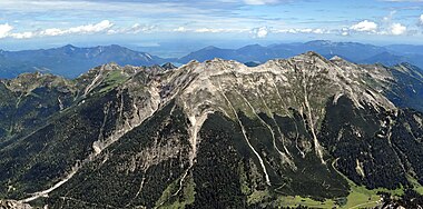
The mountains essentially consist of four huge mountain ridges in an east-west direction with deep valleys in between and a few smaller mountain groups.
Geologically the mountain region belongs to the northern limestone Alps, it consists mainly of limestone (calcium carbonate, lime: CaCO3), but also of dolomite (magnesium-calcium carbonate: MgCa (CO3) 2). The limestone of the Karwendel originated as sedimentary rock (deposits) in a shallow marine basin area with tropical temperatures.
Crystalline rocks (e.g. granite) or metamorphic rocks (e.g. gneiss) hardly occur in the Karwendel. The few exceptions are boulders or debris that were brought in as glacier cargo from the central alpine area during the Ice Ages and were deposited in the region.
Main place for the medieval Mining in the Karwendel was Schwaz, the first silver veins were discovered on Falkenstein in 1490 and turned the market, which had been poor up until then, into a large and rich silver town and the largest mining town in Europe with up to 30,000 miners in the mines. Other ore veins were located in the high valley of the Lafatsch (field name "Silberne Hansl") above Hall. Mining was also used in the Middle Ages Seefelder Gruppe (oil-bearing bitumen slate) and in Mittenwald (gold and silver, the field name that has been preserved is Goldander's hut).
The tourist development the mountains of the Karwendel took place in the 19th century, the authoritative name was here Hermann von Barth (* June 5, 1845 in Eurasburg Castle (Bavaria), † December 7, 1876 in São Paulo de Luanda, Angola, on an expedition). He is responsible for numerous first ascents in the mountains; in the summer of 1870 he climbed a total of 88 peaks, 12 of them for the first time. In 1874 he published his book "From the Northern Limestone Alps", today a classic in alpine literature. The name of the most important developer of the Karwendel still lives on in the Karwendel in the Barthgrat, in the Barthspitze and in the Barthkamin.
language
In the Inn valley on the south side of the mountain range, people speak Tyrolean, on the north side Upper Bavarian, both of which are southern Bavarian dialects.
The native dialects are not accessible to every foreigner, but the language is usually interspersed with High German, which means that the locals can also be understood by non-Bavarian native speakers.
getting there
By train
West side runs over the Munich - Innsbruck railway line Mittenwald and Scharnitz in the Inn valley. Both of the latter places are important entry points into the Karwendel Nature Park.
South-facing The Lower Inn Valley Railway runs as part of the railway line Rosenheim - Kufstein - innsbruck along the entire length of the Karwendel.
East side executes Jenbach in the Lower Inn Valley (Connection to the Lower Inn Valley Railway) the Achenseebahn to the Achensee.
In the street
The spacious approach from the north is possible over several routes:
- Via the A 96 direction Garmisch-Partenkirchen and continue on the B2 in the western part of the Karwendel Mittenwald to Scharnitz.
- From the A9 motorway (Munich - Salzburg) from which the B 307 leads across the room Tegernsee to the region around the Achensee on the east side of the Karwendel and then on to the Lower Inn Valley.
- The B 13 also leads from the Munich area Bad Tölz and Lenggries to the northern edge of the mountains.
At the South side the large-scale approach to the Karwendel is possible via the toll Inntal motorway.
mobility
It is not possible to cross the Karwendel Mountains by car, either lengthways or across, and must be avoided.
Danger: Due to construction work on the dam of the Sylvenstein reservoir, the B307 running on the dam in the north of the Karwendel is only a single lane. Therefore, the end of the construction work is expected in 2015[outdated] Particularly during the rush hour at the weekend and during the holiday periods, significant obstructions and congestion at times are to be expected at the Sylvenstein reservoir and on the connecting road from the Sylvenstein reservoir to the Achensee / Tegernsee.
Various Cul-de-sac lead as a dead end into the mountains, they are mostly toll or completely blocked for vehicles, see in each case under Valleys.
Transitions
The only alpine pass for roads is the rather inconspicuous one Achenpass right on the northwestern edge of the Karwendel and from Achensee to the Tegernsee valley.
There are also a number of crossings along the hiking trails.
Tourist Attractions

Mountains and peaks
The mountains and peaks in the Karwendel range in the technical requirements of the climbs from pure hiking mountains to pure climbing mountains, in between there is also a larger number of mountains with short climbing sections required in places and also various mountain peaks with approaches as via ferrata. The physical requirements of the climbs can, depending on the personal division of the stages, be strenuous even for those who have been trained.
Due to the poor accessibility due to the lack of roads, a whole day should only be planned for the approach to the huts for some of the tours in the interior of the mountains, the summit climbs are then at least two-day tours.
The following is a selection of interesting mountains and peaks, sorted according to the mountain ranges: the mountain ranges in the Karwendel are traditionally named after the valleys that border them in the south:
Karwendel main chain


The main ridge of the Karwendel is often referred to as the Hinterautal-Vomper chain, with the western part being the Hinterautal chain on the Hinterautal and the eastern part being the Vomperkette on the Vomper valley.
- 1 Pleisenspitze, 2,569 m high, westernmost peak in the mighty Karwendel main chain above the junction of the Karwendel valley with the Hinterautal valley. ACCESS of Scharnitz (Karwendeltäler car park) via the Pleisenhütte in approx. 4-5 hours, easy tour, but strenuous as a day tour (approx. 1,600 mH). In winter popular destination for ski touring and snowshoeing, up to Pleisenhütte (also open on weekends in winter) also for pedestrians.
- 2 Ödkar peaks (Middle: 2,745 m). Second highest Karwendelberg and immediately to the west of the Birkkarspitze.
Ascent via the "Brendelsteig": from the base Karwendelhaus to the southeast into thelauchkar, but then branch off to the west under the north face of the Ödkarspitze, over Schrofen in bends on the northwest ridge of the Ödkarspitze, over the Maxenkar to the western and on the summit ridge to the middle Ödkarspitze and eastern Ödkarspitze, descent to thelauchkarsattel, further see Birkkarspitze below .
Ridge areas are secured by wire rope, exposed in places, surefootedness and a head for heights is essential.
- 3 Birkkarspitze (2,749 m). Highest peak in the mountains above the Karwendel valley. The first ascent took place on July 6, 1870 by Hermann von Barth.
Ascent from the base Karwendelhaus to the southeast over the "lauchkar "through thelauchkar saddle (2635 m, the name says it all: 2-3 hours of arduous karschutt, better in the descent), past the emergency accommodation Birkkarhüttl and then to the east over a path secured with wire rope in about half an hour to the summit. In spring in the upper part of the inflatable cage when there is fresh snow, there is a risk of avalanches and the risk of slipping on possibly frozen snow residues, difficult orientation in fog.
The climb over the Brendelsteig is technically more demanding and also longer, it also takes place from the Karwendelhaus and by crossing the Ödkar peaks (before) and descent to the hose car saddle. From there on to the summit of the Birkkarspitzen as described above.
- 4 Lamb head (2,508 m). Dominant mountain peak in the eastern Karwendel with a striking east face to the Falzthurntal and a wonderful view of the large Ahornboden and the Achensee. Summit ascent see in Via ferratas section, The base is the Lamsenjochhütte.
- 5 Hochnissl (2,546 m). Viewpoint at 2,000 m above sea level Inn Valley. Ascent to the summit via the via ferrata see in Via ferratas section, The base is the Lamsenjochhütte.
Northern Karwendel range

- 6 Western Karwendelspitze (2,385 m). The summit marks the border between Bavaria and Tyrol and is the western cornerstone of the northern Karwendel range. The mountain is framed by the Karwendeltal and Isar valleys and, with a wide view all around, is a panoramic mountain and one of the local mountains of Mittenwald.
The summit region is quite easy with the Mittenwald Karwendelbahn Reachable, from the mountain station it is still around 20 minutes on a path with short steel rope insured passages through the rocks to the summit.
The one that opened in 2008 is also located at the mountain station of the cable car Nature information center Bergwelt Karwendel in the form of an oversized telescope. The starts from the mountain station to the south Mittenwald via ferrata, a high-altitude trail as a via ferrata in a southerly direction to the Brunnsteinanger, the saddle in front of the Brunnensteinspitze. The Dammkarabfahrt With a length of seven kilometers and an altitude difference of 1,300 meters, it is Germany's longest unprepared ski run and, if the conditions are right, a deep snow classic. The demanding descent first leads north of the cable car through a 400 meter long rock tunnel to the start of the Dammkar and then down to Mittenwald. The route is regularly checked for safety by an avalanche commission of the Karwendelbahn and only released if there is sufficient safety against avalanches. The piste was still groomed until 1999, and because of the north-facing orientation, there has been a high probability of powder snow since then.
Easiest ACCESS from the valley to the western Karwendelspitze: from the parking lot near the Karwendelbahn (920 m) in Mittenwald on a mountain trail in about 1½ to 2 hours to the Mittenwalder Hut and another 2 hours to the mountain station.

- 7 Woerner (2,476 m). Distinctive border summit (D / A) and excellent panoramic mountain in the Karwendel-Nordkette above Mittenwald. ACCESS from Mittenwald (930 m, parking lot after the railway underpass of the access road Karwendelkaserne) via the Highland hut (1,623 m) and the Wörnersattel (1,989 m). Because of several short climbing points in the second degree in the summit structure (more clearly marked since 2002), the Wörner is no longer a hiking mountain from the Wörnersattel onwards. Because of severe soil erosion, you should definitely stay on the path below the Wörner saddle.
- 8 Eastern Karwendelspitze (2,537 m). Highest peak in the northern Karwendel range and an excellent mountain with a view of the foothills of the Alps.
To the north, the Ostliche Karwendelspitze is a repelling steep wall, the ACCESS takes place on the much tamer south side and from Karwendelhaus.
Falcon group
The Falkengruppe is a smaller subgroup of the Karwendel and joins the east side Northern Karwendel range at. The mountains are rocky, steep, rugged and wild, the most famous peaks are Risser and Laliderer Falk. Only on the Steinfalk, at 2,347 meters the third highest peak of the Falkengruppe, there is a marked trail, the Falkengruppe is the least developed area in the whole Karwendel, accordingly it is lonely here. The most important base is that Falkenhütte.
- 9 Stone falcon, 2,348 m high; Easiest ACCESS from the Closely (approx. 1,200 m) to Falkenhütte (1848 m) (almost two hours for 650 m) and another two hours to the summit (500 m).
Sonnjoch Group
The seven kilometer long ridge of the Sonnjoch lies in the east of the Karwendel on the Achensee. The eponymous main summit of the Sonnjoch is the highest mountain in the region north of the Achensee and thus a parade mountain over the whole area with a not too difficult ACCESS on its south side and therefore also much visited.

- 10 Sonnjoch, 2,457 m; The south-facing ascent from the east begins at the parking lot at the Gramaialm (1,267 m, stop Bergsteigerbus 9550 of the RVO from Pertisau) and leads in the Falzthurntal to Gramai uppers (1,756 m) and on to the Gramaisattel. In a variant, also ACCESS to the Gramaisattel from the west of the Eng (1,250 m) and over the Binsalm laying down (1,500 m). The ascent over the southwest ridge begins at the saddle as a scree and craggy flank to the summit. Total ascent time: approx. 3 hours for 1,200 mH.
The north-facing ACCESS via the Bärenlahnersattel (1,995 m) and the north ridge is in the upper part a trail interspersed with loose scree and with several single climbing points a more demanding and overall somewhat longer tour in the ascent time.
Gamsjoch group
Internal chain
In the very south of the Karwendel, also known as the Nordkette because it towers over Innsbruck in the north.
Gleirsch-Halltal chain
Soierngruppe

The Soierngruppe is the smallest mountain group in the Karwendel and consists of six peaks above the two thousand meter mark, which are grouped in a horseshoe shape in the south and west around the Soiernkessel, which is open to the north. Sometimes the Soierngruppe becomes a Vorkarwendel counted. The peaks are excellent points of view of the foothills of the Alps and the Alps. The turquoise-blue Soiernsee and the smaller Soiernlache are located in the Soiernkessel.
The mountain idyll from the two lakes, mountain basins and peaks was also King Ludwig II. known: At the Soiernsee he had a royal hunting lodge built, today the Alpine Club hut Upper Soiernhaus. At night Ludwig had himself rowed across the lake in a boat, the boat had to be hauled out of the valley with difficulty. A pavilion was built for Ludwig on the Schöttelkarspitze, which he named Belvedere. For this reason, 14 m of rocks were blasted from the summit, this is where the "Kini" used to take his tea, the pavilion later burned down. The whole region and also the summit access to the Schöttelkarspitze was opened up for King Ludwig II by riding trails, today comfortable, because not too steep, hiking trails for mountain hikers.
The summit ascents in the Soierngruppe are technically not too difficult, but because of the long ascent into the Soiernkessel as day tours, they are also a bit strenuous for mountain hikers, so the Soiernhaus is recommended as a base and for overnight stays. Since large sections of the route are not protected from the sun by forest, this should be taken into account in the scheduling with an early start in midsummer.
Crossing the ridge between the peaks is also popular, also as part of a crossing or circumnavigation. Surefootedness is then required for the sections on the ridges.
- 11 Soiernspitze, 2,257 m high; Highest mountain in the Soiern group; Easiest ACCESS: In around two hours from the Soiernkessel from Soiernhaus to the summit.
- 12 Schöttlkarspitze, 2,049 m high; Easiest ACCESS: In around an hour from Soiernhaus on the formerly royal bridle path to the summit. ACCESS of Krün off in about 4½-5 hours
Vorkarwendel

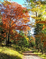
The mountains of the Vorkarwendel are somewhat gentler than those in the other parts of the Karwendel Mountains. The peaks reach heights of over 2,000 m and are popular hiking mountains, especially in autumn for the colorful coloring of the mountain forest.
- 13 Montscheinspitze (2,106 m). Demanding hiking route from the Gernalm, for more see the article on Gerntal.
- 14 Schafreuter (Sheep rider, 2,102 m). Highest summit in the Vorkarwendel, border summit between Bavaria and Tyrol, much-visited panoramic mountain and easy hiking mountain with a short steel cable insured point below the summit.

The usual normal route leads from the Riss valley and from the Lecktal car park (903 m, bus connection to Lenggries) via the Tölzer hut to the summit. An approach variant is the one from the Riss valley, parking lot at the Oswaldhütte and in just under three hours via Moosenalm and Kälbersteig (north-west degree). Both ascent routes are well signposted, a longer variant also leads from Fall over the Moosenalm to the summit. Refreshments are the Tölzer Hut (1825 m) below the summit.
- 15 Meat bank, 2,026 m high: ACCESS from the parking lot at the Fuggerangeralm (960 m) just under a kilometer behind the tollbooth, then as signposted to the summit, the last part is steel rope insured and somewhat exposed.
- 16 Seebergspitze, 2,085 m high and the 17 Seekarspitze, 2,026 m high; mark the mountain ridge in the northwest directly on the Achensee, they are connected to each other via the Wiesenkamm (ridge). Usually the two peaks are climbed together in a day tour as a medium-difficult mountain hike with a wide view of Lake Achensee.
The starting point is the hiking car park at the western end of the Achensee Achenkirch, the signposted ascent leads initially on farm roads through mountain forest to Seekaralm (1,508 m) and then partly over marked steep and exposed crags to the summit of the northern Seekarspitze. For the technically rather simple but in places somewhat exposed ridge to the southern Seebergspitze, an hour is to be expected, the way back then leads west from the ridge on alpine paths over the uncultivated Pasillalm (1,557 m) back north to the Seekaralm and to the starting point.
Duration: to the Seekarspitze approx. 3-4 hours, for the round a total of approx. 6-8 hours, (approx. 1,300 mH), surefootedness and a head for heights are required. The best time is autumn when the larches of the mountain forest turn yellow.
Valleys
Hall Valley
The Halltal is a southern Karwendel valley with access from the valley Lower Inn Valley at Absam in the north of Hall in Tirol. The valley road used to be a toll road and has been closed to individual motor vehicle traffic since 2012. Access to the valley by taxi service is possible.


Riss valley
The approx. 30 km long valley leads from the north into the central Karwendel, it separates the north-west side Vorkarwendel from the rest of the mountains. The only major settlements are Rear crack and the Almdorf Eng.
- Large maple back (1,220 m, 47 ° 24 '48 "N.11 ° 34 '25 "E): The much-visited head of the Riss valley is also called Eng and is located in the Austrian part of the Karwendel, it is drained from the Rissbach north to the Isar. The valley floor is famous for its up to 600 year old maple stands (approx. 2,000 pieces on 240 hectares) and is designated as a landscape protection area. The autumn color of the leaves of the sycamore maples is one of the most famous photo motifs in the region, but at this time of the year and when the weather is good for excursions, the large Ahornboden, which is popular all year round, and the access road through the Riss Valley, are completely overcrowded with visitors and buses. In addition to the mountain panorama, there is also excursion gastronomy.
The Driveway from May 1st to the end of October from Vorderriß (between Wallgau and Sylvenstein Speicher / Lenggries located in Germany) relatively flat over a distance of about 30 km and is also extremely popular with cyclists. Tolls for cars : € 3.50 (2013, toll booth to Hinterriß). In winter the road is not cleared and is only accessible on skis.
Out Lenggries Line 9569, known as the “Bergsteigerbus”, runs daily from mid-June to mid-October via Vorderriß and Hinterriß to the Eng.
Karwendeltal
The Karwendeltal with the Karwendelbach has its valley entrance Scharnitz in the west of the Karwendel, it separates the Northern Karwendel range from the south side Karwendel main chain. The valley is closed to vehicles. The ride through the Karwendel Valley to the Karwendelhaus is one of the most popular tours for MTB in the entire Alpine region.
Hinterautal

The Hinterautal with the source of the Isar and the young Isar separates the northern one Karwendel main chain from the southwest Gleirsch-Halltal chain, the valley access is from Scharnitz in the west of the Karwendel. The Isar valley is closed to vehicles.
Gerntal
Access from Pertisau at the Achensee via the toll road or hiking trail;
See also your own travel guide for Gerntal.
Falzthurntal
Access from Pertisau via toll road or hiking trail. There is a hiking bus (line 9550) from Pertisau.
Lakes and bodies of water

Despite its abundance of water, there are only a number of smaller mountain lakes in the mountains themselves, the notable bodies of water here are the water-rich streams in the valleys, especially in spring. The significant lake landscapes are almost all on the edge of the mountains.
- The Achensee at the east end of the mountains to Rofan down.
- The Sylvenstein Speicher, an artificial water reservoir for flood regulation of the Isar north of the Vorkarwendel.
- Soiernsee and the smaller Soiernlache, idyllic mountain lakes in the Soiernkessel der Soierngruppe.
- Kochelsee and Walchensee with the well-known power station and in a location a little north of the mountain edge.
- In the upper valley of the Isar the lake landscape at Mittenwald (Lautersee and Ferchensee) and at Krün (Barmsee and Grubsee).
Mountain streams and rivers
- The Isar has its source region in the Isar origin in the Hinterautal;
- South of the mountains of the Inn in the Lower Inn Valley (Tyrol).
Nature reserves
The nature reserve Karwendel Alpine Park was founded in 1928 and is the oldest protected area in Tyrol. The total area is 727 km², it is divided into the following protection zones:
Nature reserves are:
- Karwendel nature reserve
- Martinswand and Question Stone nature reserves in the Zirl area (near Innsbruck): the south-facing areas represent a so-called “foehn flora” with warmth-loving bushes and dry grassland.

Quiet areas are:
- Quiet area Eppzirl
- Quiet area Achental-West
Landscape protection areas are:
- Bärenkopf landscape protection area, rugged mountain landscape in the southeastern area of the Karwendel Mountains and southwest of the Achensee (above Pertisau located. Size approx. 13 km²
- Landscape protection area Falzthurntal-Gerntal,
- Landscape protection area Großer Ahornboden
- Landscape protection area Martinswand-Solstein-Reither Spitz,
- Nordkette landscape protection area
- Protected landscape area Vorberg
Information centers
- 1 Nature information center Bergwelt Karwendel (2,244 m) (in the Karwendel pit). Tel.: 49 (0)8823 93 76 76 - 0. Access: driveway with the Mittenwald Karwendelbahn to Western Karwendelspitze.Price: free entry.
The project in the form of an oversized 34 meter long telescope with a diameter of 3.80 meters that can be walked on inside is the attempt to offer an integrated environmental education offer with guided tours and improved visitor guidance in the area, in the middle of the high mountain region of the nature reserve at 2,244 m Thematically, the ice age, the folding of the Alps, the landscape and the development of the cultural landscape in the Karwendel are shown. Opened since July 2008, located at the summit station of the Karwendelbahn from Mittenwald.

- 2 Karwendel Nature Park House, Rear crack 4, 6215 rear crack (in the hamlet of Hinterriß in the Riss valley). 2009 newly opened information center of the Tyrolean nature park. Detailed information see in the article Rear crack.
- 3 Karwendel information center, Innsbrucker Strasse 282, 6108 Scharnitz (on Seefelder Strasse / Hauptstrasse, at the Isar bridge). Detailed information see in the article Scharnitz.
activities
Hiking and mountaineering
The summit ascents / normal routes to the Karwendel Mountains are briefly described for the respective peaks.
Long-distance hiking trails
- Eagle Walk: The main Tyrolean hiking trail leads in four official stages from Maurach a. Achensee via Lamsenjochhütte, Falkenhütte, Karwendelhaus, Birkkarspitze and Hallerangerhaus (stages No. 8 to 11) through the Karwendel.
- Via Alpina: The great Alpine route from Trieste on the Adriatic Sea to the Principality of Monaco leads as the "Red Path" in three stages (R41, R42, R43) from Schwaz to the Lamsenjochhütte and via the Falkenhütte to Scharnitz through the region.
- Munich-Venice: The high mountain crossing of the Alps leads in the variant from Hinterriß through the Johannisbachtal and over the Karwendelhaus and the Halleranger Alm to Wattens in Tyrol in the Inntal.
- Karwendel tour: The three-day hike through the Karwendel Mountains is popular. In the footsteps of King Ludwig II, the King Ludwig Karwendel tour ends in the Eng on the great Ahornboden.
more on this: www.koenig-ludwig-karwendeltour.com
Via ferratas
On the more demanding summit ascent, there are various parts of the ascent that are insured with a steel cable:
- To the Brendlsteig from Karwendelhaus on the Ödkar peaks see at the Ödkar peaks.
- To the Kaiser Max via ferrata, Via ferrata classics, sport via ferrata and one of the most difficult via ferratas in the entire Alps see in Zirl travel guide

Zirler via ferrata
The Ziler via ferrata is a demanding and exposed alpine via ferrata on the Erlspitze (2,404 m) with access to both Eppzirler Scharte (2,110 m), which is the base Solsteinhaus.
Hochnissl and Lamsenspitze
When approaching the Lamb head and to the neighboring one to the south Hochnissl There are approaches with several and longer via ferrata parts, the starting point is the Lamsenjochhütte.
The ACCESS through the steep northeast face (125 m almost vertical) and the ascent of the Lamsentunnel (also the Brudertunnel) is the same for both peaks, on the west side the climbs are then divided:
- To the Lamsenpitze there is still a steep ascent to the northern summit.
- To the Hochnissl in the south it is a much longer stretch of the way in the rocks of the ridge, which is repeatedly interspersed with via ferrata-like sections.
Difficulty scale KS2 (easy, heavily exposed on the ACCESS through the tunnel from the Lamsenjochhütte). The ACCESS to the Lamsenspitze is a half-day tour, the ACCESS to the Hochnissl is a day tour. Both peaks as a day tour without an overnight stay is exhausting even for the trained. Complete via ferrata equipment and a helmet are required. The base for Hochnissl and Lamsenspitze is the Lamsenjochhütte, Directions from Pertisau to Gramaialm (Parking) in the Falzturntal, ascent to the hut in approx. 2 hours.
Innsbruck via ferrata
The Innsbrucker Klettersteig is an alpine via ferrata as a ridge ascent and is located in the Hafelekar der North chain südseitig hoch über den Dächern von innsbruck (rund 2.000 Meter weiter unten), er gilt als derzeit schwerster (aber nicht zu schwerer) und längster ausgewiesener Klettersteig im Karwendel. Mit einer weiten Aussicht über das Inntal nach Süden bis zum Alpenhauptkamm, mit einem Verlauf überwiegend auf dem Grat entlang und wegen seiner leichten Erreichbarkeit mit der Seilbahn der Nordkettenbahn ist der Steig hoch attraktiv und viel begangen. Der Klettersteig wurde 2008 umfassend saniert und befindet sich in einem guten Zustand.
Üblicherweise wird der Klettersteig von Ost nach West begangen und besteht aus zwei Abschnitten:
- Der erste Teil führt vom Hafelekar (ca. 2.250 m, in Nähe der Seilbahnstation) bis zum Langen Sattel (ca. 2.260 m, Abstieg möglich). Der Teil verläuft überwiegend auf dem Grat, Dauer ca. 3 Stunden.
- Der zweite Teil führt vom Langen Sattel zum Frau-Hitt-Sattel (2.230 m) und ist der rassigere und ausgesetztere Teil, er verläuft recht verwinkelt und über Scharten, Felsentürme und senkrechte oder sogar leicht überhängende Teile. Dauer ca. 1½ Stunden.
Abschließend ist noch der Abstieg zurück zur Station Seegrube (1.905 m) der Bergbahn (ca. 1 Stunde) erforderlich.
Einstufung der Schwierigkeiten: durchgehend A und B, Stellen C und so gut wie keine längeren Gehpassagen. Beste Zeit: etwa von Mitte Juni bis Oktober, Insgesamt ca. 7 Stunden und ca. 650 Hm Höhendifferenz; Komplette Klettersteigausrüstung und Helm, evtl. Klettersteighandschuhe sind erforderlich.
Mittenwalder Klettersteig
Der Mittenwalder Klettersteig, auch Mittenwalder Höhenweg, beginnt bei der der Bergstation der Karwendelbahn aus Mittenwald unterhalb des Gipfels der Westlichen Karwendelspitze (2.384 m). Es handelt sich um eine aussichtsreiche Kammüberschreitung über zahlreiche Felsgipfel (Nördliche Linderspitze / 2.372 m, Südliche Linderspitze / 2.306 m, Sulzleklammspitze / 2.321 m, Kirchlspitz / 2.302 m) nach Süden bis in den Brunntalanger (2.095 m), einer Einsattelung im Gratverlauf, wobei der Gipfelkamm hier auch die Landesgrenze (D/A) markiert. Vom Sattel beginnt der Abstieg zur Brunnsteinhütte (1.560 m) und weiter zurück bis Mittenwald.
Bergerfahrung und Trittsicherheit ist unbedingt erforderlich, für weniger Geübte empfiehlt sich ein Klettersteigset, ein Steinschlaghelm empfiehlt sich ebenfalls. Dauer für die reine Kammüberschreitung ca. 4 Stunden, der Abstieg (1.400 Hm) sind dann nochmals 3 Stunden. In umgekehrter Richtung nur für besonders konditionsstarke, die zu Fuß aufsteigen und mit der Bahn abfahren wollen. Beste Zeit ist Mai bis Oktober.
Mountain biking
Ehemals gab es im Karwendel die sog. Tirol-Vital-Route. Diese gibt es jedoch seit einigen Jahren nicht mehr. An deren Stelle wurden Touren im Zusammenarbeit mit dem Land Tirol als offizielle Radstrecken beschildert.Diese Route und einige andere haben sich bei den Bikern als fahrbar herauskristallisiert:
Karwendeldurchquerung Scharnitz-Achensee

- Scharnitz 950 m - Karwendeltal - Karwendelhaus (1771 m:) Strecke führt über geschotterte Fahrwege (Tourenradtauglich). Nächtigung im Karwendelhaus möglich.
- Karwendelhaus 1.771 m - Hochalmsattel 1803 - Rißtal 960 m Im Bereich Hochalmsattel - Kleiner Ahornboden (1400 m) Karrenweg (für MTB fahrbar). Der Weg ist nicht tourenradtauglich. Ab dem kleinen Ahornboden geschotterte Fahrwege bis ins Rißtal.
- Abstecher Großer Ahornboden 1.220 m: vielbesuchter Talschluss (zugänglich über die Mautstraße)
- Rißtal 950 m - Plumssattel (etwa 1.650 m) The Westauffahrt vom Rißtal zum Plumssattel ist im Prinzip mit dem Tourenrad möglich (an einigen schlechteren Wegstellen muß allerdings evtl. geschoben werden. Dazu: Zuerst Fahrt auf der Mautstraße (für Radfahrer frei). Dann geschotterte Fahrwege zum Plumssattel hinauf. Nächtigung in der kleinen Plumsjochhütte möglich.
- Plumssattel (ca. 1.650 m)- Pertisau (Achensee 950 m):Ostrampe: Der Abschnitt Plumssattel - Gernalm (1166 m) ist ein sehr steiler Fahrweg an dem geübte MTB'ler ihren Spaß haben. Aufgrund des losen Schotters und der Absturzgefahr (durch Wegrutschen des Rades beim Bremsen) kann der Fahrweg für Tourenradler nicht empfohlen werden. Tourenräder schiebt man hier am besten auch bergab. Ab der Gernalm geht es auf der ausgebauten Mautstraße mit Asphaltbelag nach Pertisau.
weitere Touren
- Lamsenjoch Die Mountainbike-Route von der Engalm zur Lamsenjochhütte ist ganz neu in das Verzeichnis der offiziell genehmigten Routen aufgenommen worden. Vom Almdorf Eng geht es auf der Forststraße zur Binsalm. Von dort weiter zur oberen Binsalm zum Joch. Dort beginnt ein Trail, Unerfahrene sollten auf jeden Fall schieben, bevor die Lamsenjochhütte erreicht ist. Von dort würde könnte man auch weiter nach black drive.
- Falkenhütte. Die Tour zur Falkenhütte gehört zu den beliebteren Mountainbike-Routen im Karwendel. Entweder von Scharnitz aus oder von Hinterriss über das Johannistal. Beliebtes Fotomotiv auf der Hütte: Ein in der Luft hängendes MTB.
- See also offizielle MTB-Info Tirol überregional
- Es gibt einen kostenlosen Mountainbikeführer beim Tourismusverband zu bestellen. Auf der Website sind die 42 Routen online und GPS-Tracks kostenlos zum Herunterladen.
Winter sports
Skitouren
Alpine skiing
Skigebiete im Gebirgsinneren gibt es nicht, der Massentourismus hat im Winter seinen Weg noch nicht in die zentralen Teile des Karwendels gefunden. Die Skipisten befinden sich alle in den Randtälern.
Skigebiete im south (im Inntal):
- In the North Innsbrucks gibt es das Skigebiet Seegrube - Nordkette (Hafelkar) in der Karwendel Nordkette;
Skigebiete im east (Region Achensee):
- In Achenkirch ist das Skigebiet Christlum mit insgesamt 50 km Abfahrten das größte Skigebiet am Achensee.
- In Pertisau gibt es das kleine Skigebiet am Zwölferkopf (Karwendel-Bergbahn);
Skigebiete im Westen:
- In Mittenwald ist die Dammkarabfahrt ein anspruchsvoller Abfahrtsklassiker im Dammkar und auf einer 7 km langen, unpräparierten Piste.
Ski nordisch
miscellaneous
Wildwasserfahrten

Der Rißbach ist bei Wildwassersportlern beliebt. Detaillierte Informationen zur Strecke sind auf www.kajaktour.de to find.
Almabtrieb
Im Herbst gibt es einen Almabtrieb durch die Fußgängerzone in Schwaz. Die Kühe kommen den weiten Weg von der Engalm nach Schwaz und gehen prächtig geschmückt heim zum Marterer-Bauernhof in Schwaz.
kitchen
Bewirtschaftete Almen ohne reguläre Unterkunft (wenn nicht ausdrücklich angegeben) und Berggasthöfe in der Almenregion außerhalb von Ortschaften. Auf Almen gibt es Getränke und einfache Speisen wie Brotzeiten oder auch Suppen und die Produkte der Alm.
Almen im Süden
Almen und Berggasthöfe außerhalb der Ortschaften und im Süden des Karwendels oder mit einfachstem ZUSTIEG von Süden aus dem Tiroler Unterinntal:
- 1 Hallerangeralm (Berggasthof) (am Isarursprung am Ende des Hinterautales). Tel.: 43 (0)664 1055955 (Sommer), 43 (0)5213 5119 (Winter). 29 Zimmerbetten, 40 Matratzenlager, Duschen; keine Hunde erlaubt; Einfachster ZUSTIEG ab Hall in Tirol: ca. 2-2½ Stunden; of Scharnitz and from Mittenwald: 5-6 Stunden.
- 2 Höttinger Alm. Tel.: 43 (0)676 3056228. 15 Zimmerbetten, 15 Matratzenlager; Einfachster ZUSTIEG: Abstieg von der Bergstation der Innsbrucker Hungerburgbahn in ca. 1,25 Stunden;Geöffnet: Anfang Mai bis Anfang November.
- 3 Alpengasthof Hinterhornalm (1.522 m, privates Berggasthaus), Nr. 54, 6069 Gnadenwald. Tel.: 43 (0)5223 41375. Anfahrt aus St. Martin (890 m) auf der asphaltierten und serpentinenreichen Hinterhornstraße (mautpflichtige Bergstraße) bis zur Alm.Geöffnet: Mitte Mai bis Anfang November.
- 4 Walder Alm (1.511 m), Nr. 54, 6069 Gnadenwald. Einfachster Zusteig: Vom der benachbarten Hinterhornalm aus (siehe vor) zu Fuß auf einem Almenweg in ca. 30 Minuten bis zur Alm.Geöffnet: Mitte Mai bis Anfang November.
- 5 Ganalm. Einfachster ZUSTIEG von Terfens aus in ca. 1 Stunde auf einem bequemen Waldweg.Geöffnet: im Sommer je nach Witterung.
- 6 Stallenhütte (Stallenalm, 1.340 m, privat). Einfachster ZUSTIEG aus Vomp, Gehzeit ca. 2 Stunden.Geöffnet: im Sommer.
Almen im Osten

Almen und Berggasthöfe außerhalb der Ortschaften und im Osten des Gebirges oder mit einfachstem ZUSTIEG von Osten aus dem Raum Achensee:
Die Falkenmoosalm ist seit 2011 nicht mehr bewirtschaftet !
- 7 Bärenbadalm (1.457 m) (am Sattel zwischen Bärenkopf und Zwölferkopf). Tel.: 43 (0)664 9059345. Einfachster ZUSTIEG: Auffahrt aus Pertisau mit der Zwölferkopf-Bahn und Abstieg ca. 15-30 Minuten zur Alm.Geöffnet: je nach Witterung von Mitte Mai bis Mitte Oktober.
in the Falzthurntal, im Sommer über eine Mautraße aus Pertisau erreichbar, im Winter nur zu Fuß (14 Kilometer, Langlaufskier):
- 8 Falzthurnalm, Pertisau 23, 6213 Pertisau am Achensee.
- 9 Gramaialm (1.267 m Alpengasthof), 6213 Pertisau. Tel.: 43 (0)5243 5166. Mittlerweile mehr Hotel als Alm.
- 10 Gramai-Hochleger (1.756 m, Alpengasthof). Aufstieg von der Gramaialm (Niederleger) in ca. 2 Stunden und mit 590 m Höhendifferenz.
in the Gerntal, über eine Mautstraße aus Pertisau reachable:
- 11 Gernalm (1.166 m, Alpengasthof, Zimmer), Pertisau 24a, 6213 Pertisau am Achensee (am Ende des Gerntals). Tel.: 43 (0)5243 5579.
- 12 Pletzach Alm (1.040 m, Alpengasthaus) (im Gerntal). Tel.: 43 (0)5243 5573. Geöffnet: von Mai bis Ende Oktober und von Weihnachten bis Ostern.
- 13 Feilalm (1.372 m), Pertisau 23d, A-6213 Pertisau. Tel.: 43 (0)676 61 58 919. Geöffnet: Im Sommer, im Winter ab Weihnachten bis Ende März/Anfang April.
Im Norden des Achensees:
- 14 Gaisalm (938 m), auf einer kleinen Halbinsel direkt am westlichen Seeufer des Achensees. Bootsanlegestelle der Achsenseeschifffahrt. Zu Fuß zu erreichen aus Achenkirch über den Gaisalmsteig am Seeufer entlang und aus Pertisau über den Mariensteig (eine gute Stunde). Trittsicherheit ist erforderlich, beide Steige sind im Winter lawinengefährdet.Geöffnet: Mai bis September.
- 15 Seekaralm (1.508 m), at the Seekarspitze westlich vom Achensee. Geöffnet: Mitte Juni bis Mitte Oktober.
Almen im Norden

Almen und Berggasthöfe außerhalb der Ortschaften und im Norden des Karwendels und Vorkarwendels oder mit einfachstem ZUSTIEG von Norden:
Im Rißtal:
- 16 Oswaldhütte (820 m) (an der Straße von Vorderriß nach Hinterriß.).
- 17 Fuggerangeralm (960 m), im Talgrund des Rißtals.
- 18 Garberl Alm (966 m), im Talgrund des Rißtals.
Almdorf Eng

The Almdorf Eng ist mit rund 15 Holzhütten das größte Almdorf Europas, verwaltungstechnisch liegt es auf der Fläche der Gemeinde Vomp. Wegen der Lage direkt am Großen Ahornboden ist der äußerst idyllisch gelegene Weiler, im besonderen im Herbst bei gefärbten Ahornbäumen, wahrscheinlich der größte Publikumsmagnet im ganzen Karwendel. Im Sommer wird die Alm von etwa 500 Rindern beweidet, der Name leitet sich vom Talanger ab. Im Winter ist die Eng unbewohnt.

In der Eng gibt es einen Bauernladen mit Einkaufsmöglichkeiten (Almprodukte / Käse), ein Teil der historischen Almhütten ist museal hergerichtet. Das ganze Umfeld der Alm ist hoch beliebtes und gut erschlossenes Wanderrevier.

- 19 Rasthütte Engalm (1.250 m, Berggasthof). Geöffnet: im Sommer je nach Witterung von Mai bis Oktober.
- 20 Moar Hütte (1.250 m, Bergalm). Geöffnet: im Sommer je nach Witterung von Mai bis Oktober.
- 21 Alpengasthof Eng (Hotel * * *, 1.250 m, Wandergasthof), Eng 1, 6215 Hinteriß (am Almendorf Eng). Tel.: 43 (0)5245 231-80. Geöffnet: im Sommer je nach Witterung von Mai bis Oktober.
- 22 Binsalm (1.500 m), Hinterriß 10, 6215 Hinterriß. Geöffnet: Mitte Mai bis Ende Oktober.
Anfahrt in die Eng über die Mautstraße von Hinterriß durch das Rißtal. Zu beachten ist: im Herbst ist die eher schmale Anfahrtsstraße bei Schönwetter mehr als überlaufen sondern zeitweise einfach nur noch zugeparkt, stellenweise beidseitig. Wer einen der regulären Parkplätze ergattern möchte, sollte sehr früh anfahren.
Almen im Westen
Almen und Berggasthöfe außerhalb der Ortschaften und im Osten des Karwendels oder mit einfachstem Zustieg von Westen aus dem Raum Mittenwald / Scharnitz:
- 23 Scharnitzer Alm (im Talboden des Isartals). Tel.: 43 (0)5088040. Einfachster ZUSTIEG: Durch das Isartal aus Scharnitz in ca. ½ Stunde.Geöffnet: Ende Mai bis Anfang Oktober.
- 24 Oberbrunnalm (1.522 m). Tel.: 43 (0)664 9244460. Einfachster ZUSTIEG ab ab Gießenbach (2 km südlich von Scharnitz) auf einem Wanderweg und mit ca. 2-2½ Stunden Gehzeit.Geöffnet: Ende Mai bis Anfang Oktober.
Die 1954 abgebrannte und im Jahre 2010 neu gebaute Rehbergalm (1.560 m, auch Mathilde-Hurter-Hütte) oberhalb von Mittenwald wird von der Mittemwalder Forst- und Weidegenossenschaft betrieben und ist für den Publikumsverkehr nicht zugänglich.
accommodation

Liste der Berghütten des deutschen Alpenvereins (DAV) und des österreichischen Alpenvereins (OeAV) sowie private Hütten für Wanderer und Bergsteiger. Die meisten Hütten sind nur im Sommer (von Mai/Juni bis Oktober) geöffnet. Vor dem Aufstieg am besten noch mal mit dem Hüttenpersonal telefonieren, ob wirklich geöffnet ist. Eine Reservierung ist zweckmäßig und ist gerne gesehen. Bitte aber auch wieder absagen, wenn man dann doch nicht kommt.
Viele Hütten haben auch einen Winterraum, der außerhalb der Bewirtschaftungszeit zugänglich sind. Der Hüttenschlüssel ist in der Regel bei der zuständigen betreuenden Sektion abzuholen.
Hütten im Süden
Hütten und Unterkünfte mit einfachstem Zugang aus dem Süden des Karwendels aus dem Tiroler Unterinntal.
- 1 Nördlinger Hütte (2238 m), Innsbruck-Land, 6100, Österreich (auf dem Südgrat der Reither Spitze). Tel.: 43 664 9142262 (Hütte), Mobile: 49 176 62032531 (Tal).


 in der Datenbank Wikidata") 31 Plätze Zimmerlager, 34 Plätze Matratzenlager; ZUSTIEG von Reith bei Seefeld (1.130 m) in ca. 4 Stunden;Merkmale: 31 Betten, 34 Plätze im Matratzenlager.Geöffnet: Ende Mai bis Anfang Oktober.
31 Plätze Zimmerlager, 34 Plätze Matratzenlager; ZUSTIEG von Reith bei Seefeld (1.130 m) in ca. 4 Stunden;Merkmale: 31 Betten, 34 Plätze im Matratzenlager.Geöffnet: Ende Mai bis Anfang Oktober. - 2 Solsteinhaus (1.805 m, Sektion Innsbruck des OeAV) (westlich vom Großen Solstein). Tel.: 43 (0)664 3336531. Die Hütte wurde 2008 umfassend saniert. 22 Plätze Zimmerlager, 50 Plätze Matratzenlager, 30 Plätze Notlager, 3 Plätze Winterraum (AV-Schloss);Einfachster ZUSTIEG aus Hochzirl (920 m) in ca. 2½ Stunden.Merkmale: 40 Betten, 60 Plätze im Matratzenlager, 3 Plätze im Winterraum.Geöffnet: Anfang Juni bis Mitte Oktober.
- 3 Neue Magdeburger Hütte (Martinsbergalam, 1.633 m, DAV Sektion Geltendorf), Wetterkreuzweg 12a, 6170 Zirl. Tel.: 43 (0)664 1633861 (mobil), 43 (0)5238 88790. 23 Plätze Zimmerlager, 50 Plätze Matratzenlager, 6 Plätze Winterraum (AV-Schloss): Einfachster ZUSTIEG aus Zirl, Gehzeit ca. 2½ Stunden.Merkmale: 23 Betten, 50 Plätze im Matratzenlager, 6 Plätze im Notlager.Geöffnet: Anfang Juni bis Anfang Oktober.
- 4 Pfeishütte (1.950 m, OeAV Innsbruck) (am Ende des Samertals). Tel.: 43 (0)664 914 84 34. 30 Plätze Zimmerlager, 50 Plätze Matratzenlager, 10 Plätze Notlager; Einfachster ZUSTIEG ab Hall in Tirol: 3-3½ Stunden, aus Scharnitz: ca. 5 Stunden;Merkmale: 30 Betten, 50 Plätze im Matratzenlager, 10 Plätze im Notlager, 6 Plätze im Winterraum.Geöffnet: im Sommer von Anfang Juni bis Ende Oktober.
- 5 Hallerangerhaus (1.768 m, DAV Schwaben). Tel.: 43 (0)664 8937583. 24 Plätze Zimmerlager, 72 Plätze Matratzenlager, 12 Plätze Notlager; Einfachster ZUSTIEG ab Hall in Tirol: ca. 2-2½ Stunden; of Scharnitz: 5-6 h; out Mittenwald: 5 Stunden.Merkmale: 24 Betten, 62 Plätze im Matratzenlager, 10 Plätze im Winterraum.Geöffnet: im Sommer von Anfang Juni bis Oktober.
- 6 Aspachhütte (1.535 m, nur Bergrettungsstützpunkt, nicht bewirtschaftet, OeAV Innsbruck)
- 7 Bettelwurfhütte (2.077 m, OeAV Innsbruck), Halltal 30, 6067 Absam (am Bettelwurf über Hall). Tel.: 43 (0)5223 53353 (Hütte), Mobile: (0)699 1068 4073 (ganzjährig). 24 Plätze Zimmerlager, 38 Plätze Matratzenlager, 6 Plätze Notlager;Einfachster ZUSTIEG aus Absam (632 m) bei Hall, Gehzeit: 3½ Stunden.Merkmale: 30 Betten, 32 Plätze im Matratzenlager, 6 Plätze im Winterraum.Geöffnet: im Sommer von Juni bis Oktober.


Hütten im Osten
Hütten und Unterkünfte mit einfachstem Zugang aus dem Osten des Karwendels von der Region am Achensee aus:
- 8 Lamsenjochhütte (1.953 m, DAV Sektion Oberland) (unterhalb der Felswände von Lamsenspitze and Hochnissl). Tel.: 43 (0)5244 620 63. Die Lamsenjochhütte wurde 1906 eröffnet und gehört wegen ihrer spekatkulären Lage in großartiger Felsenkulisse und wegen der leichten Erreichbarkeit zu den beliebtesten Hütten der Region. Im Jahre 2004 wurde sie wegen vorbildlicher umweltverträgliche Bewirtschaftung mit dem Alpenvereins-Umweltgütesiegel ausgezeichnet. 31 Zimmerlager, 96 Matratzenlager; getrennte Waschräume, Trockenraum, offener Winterraum im Nebenhaus (6 Lager);Einfachster ZUSTIEG: Vom Achensee aus Pertisau in ca. 2½ Stunden;Geöffnet: Juni - Okt.
- 9 Plumsjochhütte (1.630 m, privat). Tel.: 43 (0)5243 5487. 20 Plätze Matratzenlager; Einfachster ZUSTIEG: Ab Pertisau Ab der Gernalm (bis hierher Mautstraße für KFZ): 1 - 1 1/2 h. Von der Mautstraße im Rißtal (ab Hagelbachhütte): 2 - 2 1/2h und insgesamt ca. 3½ Stunden.Geöffnet: Anfang Mai bis Ende Oktober.
- 10 Seewaldhütte (1.582 m, DAV Sektion Achensee) (auf einer Hochfläche am Fuße der Hochplatte). Tel.: 43 (0)664 3537019. Übersichtliche Berghütte ,20 Plätze Matratzenlager; Einfachster ZUSTIEG: vom Parkplatz Christlum Hochalmlifte (bei Achenkirch ) in ca. 2 Stunden 640 Höhenmeter) zur Hütte.Geöffnet: Mitte Juli bis Mitte September, ansonsten nach Witterung und unter der Woche keine durchgehende Öffnung.
Hütten im Norden
Hütten und Unterkünfte mit einfachstem Zugang von der Nordseite des Karwendels.
- 11 Falkenhütte (1.848 m, DAV Oberland/ München), 6215 Hinterriß, Österreich (am Fuß der Lalidererwände). Tel.: 43 (0)5245 245. 28 Plätze Zimmerlager, 120 Plätze Matratzenlager, offener Winterraum mit 11 Plätzen; Einfachste Zustiege: ab Hinterriß / Alpenhof (950 m) 3½ Stunden, ab Eng im Großen Ahornboden (1.218 m) 2½ Stunden. Achtung: Wegen Umbau bis auf weiteres geschlossen!Merkmale: 28 Betten, 120 Plätze im Matratzenlager, 8 Plätze im Winterraum.Geöffnet: Juni bis Oktober.


- 12 Tölzer Hütte
 (1.825 m, DAV Bad Tölz), Tölzer Hütte, Eben 1, A-6215 Hinterriß (am Schafreiter). Tel.: 43 (0)664 180 179 0. 18 Plätze Zimmerlager, 55 Plätze Matratzenlager, offener Winterraum mit 4 Plätzen;Einfachste Zustiege: ab Weiler Fall, 4-6 Stunden (verschiedene Wege), vom Parkplatz nahe Hinterriß (Gasthaus Kaiserhütte, 850 m) Gehzeit: 2½ Stunden.Merkmale: 25 Betten, 44 Plätze im Matratzenlager, 4 Plätze im Winterraum.Geöffnet: Mitte Mai Juni bis Mitte Oktober.

Detailierte Informationen siehe auch im Reiseführer Tölzer Hütte.
- 13 Rotwandlhütte (1.525 m, DAV Neuland/München). Die Hütte ist nur für Mitglieder des Vereins zugänglich.
Hütten im Westen
Hütten und Unterkünfte mit einfachstem Zugang aus dem Westen des Karwendels aus der Region Mittenwald / Scharnitz:
- 14 Oberes Soiernhaus (1.616 m, DAV Sektion Hochland) (über dem Soiernkessel). Tel.: 49 (0)171 5465858. Die Berghütte wurde im Jahre 1866 als Königliches Jagdhaus für König Ludwig II. erbaut und 1920 von der Sektion Hochland als Bergsteigerunterkunft übernommen. Ausstattung: 60 Schlafplätze im Matratzenlager;Einfachster ZUSTIEG: über Krün (875 m) - Fischbschalm: 3,25 Stunden (Nächster Bahnhalt ist Klais. ca 1 Stunde zu Fuß von Krün entfernt).Geöffnet: von Anfang / Mitte Mai bis Mitte Oktober.
- 15 Hans-Mertel-Hütte (1.560 m, DAV Sektion Hochland) (am Soiernsee). Entstanden als Pferdestall zum Jagdhaus für König Ludwig II. Die Hütte ist nur für Mitglieder des Vereins zugänglich.
- 16 Krinner-Kofler-Hütte (1.407 m, bewartete Selbstversorgerhütte DAV Sektion Mittenwald), Im Schwarzenfeld 16, 82481 Mittenwald (auf der Fereiner Alm westlich der Soiernspitze). Tel.: 49 (0)8823 5584 (Hüttenwart). 30 Schlafplätze im Matratzenlager; Einfachster ZUSTIEG: Vom Wanderparkplatz Aschauer Alm nördlich von Mittenwald in 2-3 Stunden.Merkmal: 30 Plätze im Matratzenlager.Geöffnet: Anfang Juni bis Mitte September.


- 17 Hochlandhütte (1.623 m, DAV Hochland/München), Schöttlkarstr. 10, 82481 Mittenwald. Tel.: 49 (0)174 9897863. 39 Schlafplätze Matratzenlager, 12 Schlafplätze im Notlager; Einfachster ZUSTIEG aus Mittenwald: ca. 2-2½ Stunden (P nach Bahnunterführung nordseitige Kasernenanfahrt).Merkmale: 39 Plätze im Matratzenlager, 12 Plätze im Notlager.Geöffnet: von Ende Mai bis Mitte Oktober, im Winter wegen Lawinengefahr geschlossen.

Tourenmöglichkeiten:
- Wörner (2.476 m, der Hausberg der Hütte) ca. 3 Stunden , Tiefkarspitze (2.431 m), ca. 3½ Stunden Mittlere Großkarspitze (2.361m), ca. 2½ Stunden;
- Nördliche Großkarspitze (2.426 m), ca. 5 Stunden, Südliche Großkarspitze (2.289 m) ca. 3 Stunden, Hochkarspitze über Wörner (2.484 m), ca. 5 Stunden;
- 18 Dammkarhütte (1.650 m, privat), Schöttlkarstr. 10, 82481 Mittenwald (am Dammkar). Tel.: 49 (0)173 3514659. 12 Schlafplätze im Matratzenlager (Reservierung unbedingt sinnvoll);Einfachster ZUSTIEG: von der Talstation der Karwendelbahn (in Mittenwald) ca. 2,0 h;Geöffnet: von Anfang / Mitte Mai bis Mitte September.
- 19 Bettelwurfhütte (1.518 m, DAV Mittenwald) (auf halber Höhe an der Karwendelbahn). Tel.: 49 (0)151 17303118 (Hütte), 49 (0)8825 1262 (Tal).
 27 Plätze Matratzenlager, 5 Plätze Notlager; Einfachster ZUSTIEG aus Mittenwald vom Parkplatz der Karwendelbahn in ca. 1½ Stunden.Merkmale: 30 Betten, 32 Plätze im Matratzenlager, 6 Plätze im Winterraum.Geöffnet: von Mitte Mai bis Ende Oktober.

- 20 Pleisenhütte (1.757 m, privat). Tel.: 43 (0)664 9158792. Interessant ist die Geschichte der Pleisenhütte, die von Toni Gaugg nach dem Krieg noch ohne die Zufahrtsstraße zum Antransport der Baumaterialien alleine erbaut wurde; 40 Lagerplätze; Einfachster ZUSTIEG vom Parkplatz Karwendeltäler in Scharnitz in ca. 2-2½ Stunden. Tourenmöglichkeiten: Pleisenspitze (2-2½ Stunden). Querung zum Karwendelhaus.Merkmal: 40 Plätze im Matratzenlager.Geöffnet: im Sommer von Anfang Juni bis Ende Oktober, im Winter nur an den Wochenenden.
- 21 Karwendelhaus (1.765 m, DAV-Sektion MTV Männer-Turnverein München). Tel.: 43 (0)720 98 35 54. Das Karwendelhaus wurde 1908 erbaut und seitdem verschiedentlich modernisiert und erweitert. Die Berghütte gilt als vergleichsweise komfortabel und geräumig bei einer guten Essensauswahl. Die Hütte ist tagsüber und bei schönem Wetter von Mountainbikern übervölkert.Merkmale: 50 Betten, 24 Plätze im Winterraum.Geöffnet: im Sommer von Anfang Juni bis Mitte Oktober.


Ausstattung: 52 Betten, 141 Lager, Winterraum mit 14 Lagern, Dusche, getrennte Waschräume, Trockenraum, Schuhraum;
Einfachste Zustiege: aus Scharnitz (964 m, gebührenpflichtiger Großparkplatz) durch das Tal des Karwendelbachs in ca. 4½ Stunden; out Hinterriß (848 m, mautpflichtige Anfahrtsstraße) in ca. 3½ Stunden durch das Johannistal und über den Kleinen Ahornboden. Alle Zustiege sind technisch völlig unschwierig, aber nach der Strecke "lang", die Anfahrt aus Scharnitz ist bei Mountainbikern äußerst beliebt und wird daher verschiedentlich von Wanderern gemieden.
Tourenmöglichkeiten: Birkkarspitze (2.749 m), Ödkarspitzen (2.745 m), Östliche Karwendelspitze (2.537 m);
- 22 Brunnsteinhütte (1.523 m, DAV Sektion Mittenwald). Tel.: 49 (0)8823 326951. 42 Schlafplätze im Matratzenlager; Einfachster ZUSTIEG aus Mittenwald oder aus Scharnitz jeweils ca. 1½-2 Stunden;Merkmal: 39 Plätze im Matratzenlager.Geöffnet: Mai bis Oktober, im Winter an schönen Wochenenden.

Biwakschachteln
Notunterkünfte und Unterstandshütten mit vier Wänden und einem Dach, im Regelfall keine weitere Ausstattung und keine sonstige Infrastruktur.
- 23 Birkkarhütte (2.635 m, DAV Sektion MTV, Männer Turnverein München)
- 24 Breitgrieskarschartenbiwak (2.388 m)
- 25 Lalidererspitzen-Biwak (Karl-Schuster-Biwak, 2.500 m, OeAV Innsbruck)
climate
Das Klima im Karwendel ist stark unterschiedlich und reicht von der gemäßigten Zone eines milden und geschützten Alpentals am Inn, in Zirl an der Südseite des Karwendels wird Weinbau betrieben, bis in das extreme Klima im hochalpinen Bereich über 2.000 m Höhe, die höchsten Berggipfel erreichen fast 2.800 Meter Höhe.
Für die Wetterverhältnisse am Berg großen Einfluss haben die Nordstaulagen: die atlantischen Tiefdruckgebiete treffen auf die Nordseite des Karwendels als den ersten höheren Gebirgszug der Alpen, überdurchschnittlich kräftige Regenfälle im Sommer und heftige Schneefälle im Winter, meist deutlich mehr als am Alpenhauptkamm, sind die Folge. Nebel im Karwendel ist eher selten.
Maßgebend für die klimatischen Verhältnisse der allgemein tief eingeschnittenen Täler im Inneren des Karwendels ist ihre überwiegende Ausrichtung in Ost-West Richtung: Der Südföhn kann im Frühjahr nicht in die oft noch tagsüber im Dauerschatten verbleibenden Böden der Täler eingreifen, der Schnee hält sich damit recht lange und verschiedentlich an Nordseiten bis in den Frühsommer hinein.
- ÖAV - Alpenverein - Wetterdienst;
- Lawinenwarndienst für Bavaria.
- Lawinenwarndienst für Österreich
literature

: Karwendel–Rofan, 60 Gipfeltouren, Höhenwege, Klettersteige. Munich: Bruckmann, 2008, Tourenführer, ISBN 978-3-7654-4570-5 ; 216 Seiten. 19,95 €
- siehe auch den Artikel Rockclimbing - enthält außerdem Infos zum Thema Bergwandern;
cards
- Bayerisches Landesvermessungsamt "Karwendelgebirge" 1:50000, Blatt UKL30, Wanderwege, Radwanderwege, GPS-Gitter.
- Freytag & Berndt (1:50.000) Blatt WK323, WK5322 (Wanderer, Rad und Schitourenkarte).
- Alpenvereins Karten (1:25000) Blatt 5/1, 5/2, 5/3. (für Bergsteiger)
- Wanderkarte Karwendelgebirge 1:50000Kompassverlag (Blatt 26) inkl. informativem Beiheft mit Sehenswürdigkeiten, Wandertouren und Hüttenliste. Die Karte enthält auch Rad und MTB-Routen. Diese sind allerdings lediglich als grüne Linie eingezeichnet. Preis 6,95 Euro. ISBN 3-85491-027-4 (Datenstand 08-2006)
Web links
- The Ahornboden - Hauptattraktion im Karwendel
- Alpenpark Karwendel - offizielle Seite des Alpenpark Karwendel.
- Alpenwelt KarwendelTouristinfo For Mittenwald, Krün und Wallgau.
- Silberregion Karwendel - offizielle Website der Silberregion Karwendel mit aktuellen Wettervorhersagen, Unterkünften, Veranstaltungen im Karwendelgebirge.
- The Karwendel - grenzüberschreitende Urlaubsinformationen im Karwendelgebirge Reiseblog
