.jpg/300px-Luftbild_Alpen_04_(RaBoe).jpg) | ||
| Wetterstein Mountains | ||
| federal state | Bavaria | |
|---|---|---|
| Residents | unknown | |
| no value for residents on Wikidata: | ||
| height | 2,962 m | |
| no tourist info on Wikidata: | ||
| location | ||
| ||

The Wetterstein or the Wetterstein Mountains with the Zugspitze belongs to the northern chain of the Limestone Alps and is located in Bavaria and in Tyrol.
Regions
The Wettersteingebirge consists of three main ridges that converge at the Zugspitze summit in the western part of the mountains:
- The Waxenstein ridge in the northwest of the mountains near Garmisch runs from northeast to southwest to the Zugspitze;
- The Blassenkamm extends as a middle ridge from the east-north-east coming from Partenkirchen over the Alpspitze to the Zugspitze;
- The Wettersteinkamm (also: Wetterstein-Hauptkamm) runs along its entire width in the south of the mountain range and from the east (Mittenwald and Leutasch) to the west to the Zugspitze.
That lies between the Waxensteinkamm and the Blassenkamm Hell Valley, that lies between the Blassenkamm and Wettersteinkamm Reintal in the central part of the mountain range. The Gaistal marks the southern edge of the Wetterstein.

places
in Bavaria
- Garmisch-Partenkirchen: 700-800 m; Health resort and international tourism and winter sports center.
- Grainau: 750 m; Zugspitzdorf and high altitude health resort.
- Mittenwald: 913 m; Climatic health resort and tourist center at the foot of the western Karwendelspitze.
in Tyrol
- Ehrwald: (1000 m); Climatic health resort at the foot of the Zugspitze.
- Lermoos: (1004 m);
- Leutasch: (1050-1130 m); Mountain community at the foot of Wetterstein and Hoher Mouth.
background

Geographically is the Wetterstein on its south side with the Gaistal of the Mieming chain delimited on the east side by the Isar valley from Karwendel, on the north side of the Kankerbach and Kranzbach zum Ester Mountains (Bavarian Prealps) and on the west side through the Ehrwald Basin from the Lechtal Alps and from the Loisach to the Ammergau Alps delimited. The dimensions from west to east are around 23 kilometers, from north to south around 10 kilometers. The highest point is the summit Zugspitze (2,962 m), the base varies between approx. 700 and 1000 m depending on the side.
In the Alpine Club division, the Wetterstein becomes with the Mieming chain run as a common mountain group.
Administrative belongs to the Upper Bavarian North side of the Wetterstein Mountains for Werdenfelser Land (Garmisch-Partenkirchen district). The south side of the Wetterstein belongs to North Tyrol, with the western part with Ehrwald to the Except far, the eastern part on Seefeld plateau to the Tyrolean Oberland belongs..

Geologically the Wetterstein belongs to the Northern Limestone Alps. The Wetterstein limestone was formed around 240-210 million years ago as a deposit in a warm and shallow sea. The biggest Karst regions are the Zugspitzplatt and the Leutascher Platt. As a result of the weathering of the limestone, there are numerous caves in the mountains; over seventy caves are known in the Zugspitzplatt area alone. Another consequence of the weathering of the Wetterstein limestone and typical of the Wetterstein are the many cirques with their huge scree and rubble heaps in the lower and middle part of the mountain flanks.
Mining has been in operation since the end of the Middle Ages: iron vitriol was mined south of Hammersbach in the 16th century, lead and zinc in Höllental and also near Scharnitz. However, the deposits were not productive and were later abandoned. At the beginning of the 20th century, yellow lead ore was mined in Höllental: the mineral contains molybdenum, an important additive in steel production. The occurrence in Höllental was the only one in Germany and was therefore of strategic importance for the armaments industry at the time.
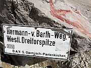

The most famous tourist developer The alpinist was also an alpinist with numerous first ascents in the Wetterstein Mountains Hermann von Barth (1845 - 1876), his name still lives today in Hermann-von-Barth-Weg on the Partenkirchner Dreitorspitze (Westl. Dreitorspitze).
Another well-known name is that of the engineer Adolf Zoeppritz, who was chairman of the Garmisch-Partenkirchen Alpine Club section from 1901 to 1933. Among other things, the Höllentalklamm was developed under Zoeppritz. According to Adolf Zoeppritz that is Mountain hut on the Kreuzeck in the north of the Alpspitze named.
The Wetterstein Mountains became a popular destination for tourists, those seeking relaxation and nature lovers with the opening of the Munich-Garmisch railway connection in 1889. With the opening of the railways to the Zugspitze between 1926 and 1930, the Wetterstein also became an internationally important tourist destination.
 panorama complete Wettersteinkamm from the south: Im foreground the Gaistal and Leutasch on the right; Back left: snow-covered Zugspitzplatt with the Zugspitze about in the middle behind and the incision of the gate in front of it; in the left third of the image Hochwanner and the snow-free cone of the Predigtstuhl lower in front of it; about center Garmischer and Leutascher Dreitorspitze; right miter tip; on the far right behind Leutasch the Arnspitze and that Karwendel (Summit in clouds). |
language
The dialect researchers assign the north side of the Wetterstein Mountains to the southern Bavarian dialect, whereby the classification according to the old Bavarian dialects in the region and also generally independent of the national borders applies to the Bavarian and Tyrolean side. In the Tyrolean towns of Ehrwald and Leutasch there is also an element of the Swabian-Alemannic dialect, which has its origins in the historical and cultural ties of the Besides remote via the Zwischenentorental and the adjoining Allgäu in the Swabian-speaking area.
getting there
By plane
The nearest airport is that Innsbruck Airport, Distance from the east of the region approx. 30 km and around half an hour's drive. The international Munich Airport can be reached from Garmisch-Partenkirchen in a good hour (approx. 120 km away). Other airports in the area around the Wetterstein are Memmingen Airport (Allgäu Airport, around 140 km away) and also the Salzburg Airport (170 km away).
By train
The valley locations in the west, north and east are easily accessible by train:
Garmisch-Partenkirchen and Mittenwald have intercity stations on the route Munich (Starnberg wing station) - innsbruck. ICEs run to and from Hamburg, Berlin and the Ruhr area.
From Garmisch-Partenkirchen the Ausserfernbahn with station in Ehrwald above Reutte further to Pfronten and Kempten in the Allgäu.
In the street
The spacious approach from north (Germany area) is easiest to use Munich and from there on the A95 (Munich - Garmisch autobahn) to the end of the autobahn at Eschenlohe and then continue on the B2 federal road (German Alpine Road) to the north side of the Wetterstein.
The spacious approach from south (Tyrol area) takes place through the Inntal valley and on the Inntal motorway A12:
- Come from the east
 Zirl / West (west of innsbruck), further over the Zirlerberg and Scharnitz to the east of the Wetterstein Mountains;
- From the west of the Upper Inn Valley coming across the Fernpass route (B179): Imst and over Nassereith and the Fernpass on to Ehrwald and to the west of the Wetterstein Mountains;
mobility
Passable for motor vehicles Routes in the interior of the mountains there is no.
A Bypass of the Wetterstein Mountains on the federal highways is possible on three sides in the surrounding valleys: in the west (Except far) in the Loisachtal on the Austrian federal highway B 187 and on the German side on the federal highway B23 Grainau to Garmisch-Partenkirchen. On the north side, the B2 federal road from Garmisch leads to Mittenwald on the east side and further back to Austria Scharnitz.
Under normal conditions, these federal highways are easy to drive even in winter. The sections between Mittenwald and Scharnitz and between Garmisch and Ehrwald can be closed after heavy snowfall due to the danger of avalanches.
There are no roads for cars in the south of the Wetterstein, the Gaistal is not accessible to motorized traffic, so it is not possible to bypass the entire mountain range by car.
Mountain railways

The mountain railways that operate in summer on and in the Wetterstein Mountains are the cable cars of the ski areas. They are Mountain railways to the Zugspitze and on the Osterfelderkopf (Alpspitz ski area), see also the section Alpine skiing.
Transitions
There are no Alpine passes as routes in the Wetterstein.
Even for normal mountain hikers without special climbing skills, crossing the mountain ridges on the hiking routes is only possible at certain and then well-known crossings:
Ripple notch
The Ripple notch (2,161 m, 47 ° 24 ′ 12 ″ N.11 ° 8 ′ 33 ″ E) is the only crossing over the Waxensteinkamm in the northwest of the Wetterstein, it is the high point of the Riffelsteig from the Höllental in the valley of the Loisach to the Eibsee. The ascent from the Höllental is an alpine path with a short insured section, the ascent from the west (Eibsee) has the character of a simpler via ferrata in the upper part (approx. 30 minutes walk), is insured with steel ropes throughout and also has deep views, A via ferrata set is recommended for the less experienced.
Gatterl
The Gatterl (2,024 m, 47 ° 23 '47 "N.11 ° 1 ′ 0 ″ E) is the only crossing over the western part of the Wetterstein main ridge in the southwest of the mountains, it leads from the Gaistal into the Reintal. In the approach immediately before the transition (Max-Klotz-Steig) there are some light and short rocks secured by wire rope to overcome, otherwise it is a high alpine climb.
The gate also marks the German-Austrian border and was checked by customs officers before the Schengen Agreement. The transition is on the highly attractive route of the footpath from Ehrwald (Max-Klotz-Steig) to the Zugspitzplatt with the Knorrhüttte and on to the Zugspitze summit. This route is one of the easier climbs on the Zugspitze, it is also used for the annual Zugspitzlauf.
Dreitorspitzgatterl

The Dreitorspitzgatterl (2,366 m, 47 ° 24 '43 "N.11 ° 7 '44 "E) is the only crossing in the eastern part of the Wetterstein main ridge and marks the border between Bavaria and Tyrol Meilerhütte. The transition is the high point in the hiking trail from the north (Partenkirchen) on the Schachen, the Leutascher Platt and the Söllerpass to Leutasch (Path No. 818 and No. 808).
Söllerpass
The Söllerpass (2.259m, 47 ° 24 '8 "N.11 ° 8 ′ 19 ″ E) is located in the eastern part of the Wetterstein and is the transition on the southern edge of the Leutascher Platt on the hiking route from Leutasch to Meilerhütte. The approach on the Leutascher side (path 818) through the Puittal is demanding, the steep Söllerrinne in the upper part is at risk of falling rocks (possibly helmet) and in places also a bit exposed. The route is recommended for inexperienced climbers. Alternatively, you can descend to Leutasch on the easier route No. 808 further north.
Tourist Attractions
Mountains and peaks
Many of the mountain peaks in the Wetterstein clearly exceed the 2000 altitude mark for high mountain regions. Together with the rocky character of the mountain flanks, this means that the peaks of the Wetterstein are always at least technically and physically more demanding destinations, even for more experienced hikers. Some of the striking peaks are even challenging climbing destinations.
For mountain hikers without a special high-alpine experience, easily suitable summit destinations in the form of the "grass humps", which are often found elsewhere, do not exist in the central parts of the mountains. With the development of the Wetterstein via the well-developed network of paths and with the Mountain huts and Alpine pastures But there is also a larger number of scenic hikes along the valley flanks for the less ambitious mountain hikers, also to crossings into the neighboring valleys and often with many other tourist highlights on these hiking trails.
The following is a selection of important mountain peaks that are particularly interesting for visitors, sorted by height:
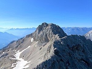
Zugspitze
The Zugspitze (2962 m), is Germany's highest point, it is in the west of the mountains and with mountain railways Grainau and from Ehrwald Well developed for tourism, several climbs and via ferratas lead to the summit with viewing platforms, restaurants and mountain huts.
The Zugspitze is in its own items dealt with in detail
Hochwanner


The Hochwanner (2,744 m), is the highest point in the Wetterstein main ridge with a steep rock face on the German side above the Reintal.
The border between Germany and Austria runs over the summit and is variously counted as one of the highest mountains in Germany. Historically and after its development, however, the mountain belongs to Tyrol: the alpine pastures as the agricultural areas are exclusively on Austrian land, and the ascent is usually from the south side. It was not until the history of climbing after the First World War that the first routes were made accessible through the previously inaccessible rock faces on the north side of Bavaria.
The ascent takes place from the south side of the Gaistal over the Rotmoosalm (1904 m). The relatively little frequented ascent to the summit is only recommended for experienced hikers: a little below the summit there is a gully to climb through, there is also a risk of falling rocks from those who climb ahead. In the remaining part of the route to the summit, good orientation skills are required in fog.
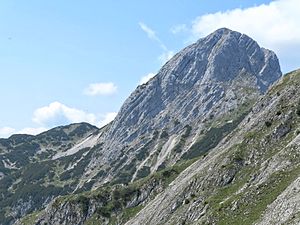
Alpspitze

The Alpspitze (2,628 m, 47 ° 25 '47 "N.11 ° 2 '53 "E), is an eastern neighbor of the Zugspitze and one of the local mountains of Garmisch. The pyramid shape visible far to the north with sharply cut edges makes the Alpspitze the most distinctive mountain in the Wetterstein.


With the cable cars to the Kreuzeck (Kreuzeckbahn) and on the Osterfelderkopf (Alpspitzbahn), two smaller elevations in the north of the Alpspitze, this alpine region is very easy and quick to reach for hikers. The area in the north of the Alpspitze is well developed with hiking trails in summer and is accordingly popular, in winter the Garmischer is located here Alpspitze ski area. In the east of the Alpspitze lies the Grieskar, which can be reached on hiking trails Stuibensee (1,922 m).
Alpspix is a spectacular viewing platform on the Osterfelderkopf that opened in July 2010: it is two to three meters wide and thirteen meters cantilevered, arranged one above the other and crossed in plan with a view of the Zugspitze and 1,000 meters down into the Höllental. Location of the Alpspix: directly above the mountain station of the Alpspitzbahn on the Osterfelderkopf, free access.
There are several Climbs and from all sides to the summit of the Alpspitze, to climb the Alpspitze you need surefootedness and a head for heights, the easiest starting point to reach is the mountain station of the cable car to the Osterfelderkopf (Alpspitzbahn, 2,033 m, 47 ° 26 ′ 21 ″ N.11 ° 3 '4 "E).


- The most famous ascent is the much-traveled one Alpspitz Ferrata through the north wall and in the upper part over the north ridge. It is a consistently easy alpine via ferrata (A / B and A) with only short, moderately difficult passages (B). The Alpspitz-Ferrata is considered to be an "overinsured" via ferrata: a lot of iron was built into the rungs and pins, the via ferrata is therefore particularly recommended for beginners and to a certain extent also for older, experienced children with sufficient fitness. A helmet is required to protect against falling rocks, experienced via ferrata climbers are occasionally out and about without a via ferrata set.
- Approach to the start of the via ferrata (47 ° 26 '4 "N.11 ° 3 ′ 1 ″ E) in a good 15 minutes from the mountain station of the cable car to the Osterfelderkopf, time for the via ferrata to the summit of the Alpspitze approx. two hours for approx. 650 mH ascent. It is common to climb through in the direction mentioned, and those who descend the Alpspitz-Ferrata must expect more oncoming traffic.
- The rise over the East ridge also has several via ferrata-like passages secured with a steel cable in the lower part. In the upper part, the ascent on the east side runs mainly on rocks and the steep scree and rubble of the east flank. The route on the east ridge is mainly used as the descent route. Then return via the Nordwandsteig (in places a little risk of falling rocks) back to the Osterfelderkopf in about 2.5 hours.
- The rise or fall on the Southwest ridge starts or ends at the Grießkarscharte (2,465 m, 47 ° 25 '35 "N.11 ° 2 ′ 29 ″ E), that is the transition from Grieskar to Matheisenkar, the southwest ridge also has several via ferrata-like passages secured with a steel cable. The southwest ridge is also used as part of the descent from the Jubiläumsgrat and Hochblassen. The further descent from the Grießkarscharte through the Matheisenkar down to the Hell Valley and up to Höllentalangerhütte is possible, but the route is extremely long (approx. 1,380 mH) and exhausting with heavy knee wear because it is very steep.

- refreshment possibility that is before the start of the Alpspitzferrata Alpspitze restaurant at the mountain station on the Osterfelderkopf. Accommodation is in Kreuzeckhaus (1,652 m) possible, another stop is the Hochalm (1,705 m).
The Bernadeinkopf is a pre-summit north of the Alpspitze and east of the Osterfelderkopf, which is easily accessible with a hike from the Osterfelderkopf and a short ascent.
The Mauerläufersteig (Bernadeinkopf via ferrata) is a new one opened in 2009 Sports via ferrata. The technically extremely demanding tour with 400 meters of steel cable and flying fox is considered to be one of the most difficult via ferratas in Germany, if not the most difficult at the moment (places D / E, very often D). The via ferrata leads steeply through the north face of the Bernadeien to the Bernadeienkopf and takes about 2.5 - 3.0 hours with a good four hours for the tour in total.
Partenkirchner Dreitorspitze
The Partenkirchner Dreitorspitze (2634 m) is the highest German peak in the eastern part of the Wetterstein.
The approach is from Garmisch via the Schachen and usually with an overnight stay in the Meilerhütte. This is where the Hermann-von-Barth waywhich leads to the summit in about 1 1/2 hours as an easy via ferrata. Descent like ascent.
Upper Wettersteinspitze

The Upper Wettersteinspitze (2297 m, 47 ° 25 '36 "N.11 ° 11 ′ 20 ″ E) is a steep mountain with a view and is located in the very east of the Wetterstein ridge. The Obere Wettersteinspitze is also the only summit in the easternmost part of the Wettersteinkamm that is accessible for "normal mountain hikers"; real climbing is required for the neighboring summits, the ridge crossing to the neighboring Rotplattenspitze (2,399 m) in some places requires the III. Difficulty level in climbing.
Because of the strenuous and demanding approach, the summit of the Upper Wettersteinspitze is not so often visited, but it rewards with a wide view on all sides of the valley of the upper Isar, to Leutasch and up to the Zugspitze. The summit is a border summit between Bavaria and Tyrol.

Out for the long climb Mittenwald (912 m, hiking car park to Lautersee) surefootedness and a head for heights are required. The route initially leads almost flat in the valley floor (Laintal) on a road past the Ferchensee and Lautersee, then the signposted ascent to the Upper Wettersteinspitze branches off to the south. In the lower part, the route leads in many bends through a highly attractive cirque with a lot of arduous rubble and scree to Gamsanger (approx. 1,900 m). From here begins the via ferrata-like section to the summit, secured with steel cables (passages I, possibly helmet). Total approach time to the summit approx. Four hours and more, mainly on the shady north side, but only in the lower part in the mountain forest. When wet, the ascent can be uncomfortable and also dangerously greasy.
Descent like ascent that Ferchensee and the Lautersee are then two excellent bathing opportunities and also with the opportunity to stop, which should definitely be included in this tour. During the day, a bathing bus runs from both lakes to the center of Mittenwald, which considerably shortens the way back.
Mitred tip
Located in the eastern part and above the Leutasch valley,
Great Arnspitze

The Great Arnspitze (2,196 m, 47 ° 23 '50 "N.11 ° 13 '35 "E), is the highest peak in the Arnspitz Group, a sporadic group of mountains southeast of the Wettersteingebirge with strikingly rugged rock peaks (Arnplattenspitze, 2171 m, Mittlere Arnspitze, 2091 m, Große Arnspitze, 2196 m), which is separated by the valley of the Leutascher Ache, but is added to the Wetterstein. The summit of the Großer Arnspitze is the border summit between Bavaria and Tyrol.


The Arnspitze nature reserve was designated as a largely untouched natural landscape in 1942, is 10.8 km² and is mainly located in Tyrol and parts of Bavaria. It includes montane, subalpine and alpine regions from 1000 m to 2196 m altitude. There is a high diversity of biotopes in the nature reserve and, as a sign of the Ice Age glaciation, moraines and glacier cuts. If you come at the right time of year in the mountain spring, you can watch gentian blossoms (blue and yellow), alpine rose blossoms and the flight of the apollo butterfly at the same time.
The Boarding to the Great Ahrnspitze is possible in two not too difficult variants:
- Boarding from Leutasch: almost immediately on Gasthof Mühle (approx. 1020 m, 47 ° 25 ′ 12 ″ N.11 ° 13 '35 "E) a steep path branches off from the brook to the southeast and leads through the Schartental valley, protected from the sun and with many bends in the forest, to the Riedbergscharte (1,449 m), where the ascent combines with a longer ascent Mittenwald. From the Riedbergscharte it goes south on a ridge, then under the eight heads and in a traverse through a steep flank to the Arnspitzhütte.

- Boarding from Scharnitz (960 m, Isar bridge, 47 ° 23 '48 "N.11 ° 15 '59 "E), from the northern outskirts and through mountain forest and pine fields steeply to the Arnspitzhütte.
The Arnspitzhütte (1,930 m), an unmanned emergency shelter that is open all year round, is located southeast of the summit and in front of the summit ascent of the Großer Arnspitze, where both climbs converge.
From the Arnspitzhütte the combined ascent leads through steep craggy slopes to the cross-less main summit. Surefootedness is required here, a head for heights certainly doesn't hurt. The view from the summit stretches far to the north into the valley of the upper Isar and to the south over the Leutasch plateau.
The summit cross is then located on the lower north-eastern secondary summit, which can be reached with a branch shortly before the main Gifel and only after a short and also exposed climbing, the other peaks on the Arnspitz group also require real climbing.
For the scenic ascent from Leutasch a good four hours and approx. 1,300 mH (some counter-climbs) are to be expected, from Scharnitz it is a little faster. Both ascent variants are possible as a descent, in the time a little faster than the ascent. There are no places to stop for a break on the way.
glacier
| glacier | location | surface | Altitude | Thickness (as of 2013) |
|---|---|---|---|---|
| Northern Schneeerner | Zugspitzplatt | 30 ha | 2,550 - 2,800 m | 52/17 m |
| Southern Schneeerner | Zugspitzplatt | 5 ha | 2,550 - 2,650 m | 17 / 4.5 m |
| Höllentalferner | Zugspitze north side | 25 ha | 2,200 - 2,550 m | 48/10 m |

There are three of the five still counted in the Wetterstein Mountains German glacier, all are located on the Zugspitze or on the Zugspitzplatt. "Still" means that they are all severely affected by the glacial melt, the loss is up to one meter thick per year.
In addition to the glaciers, there are a number of larger ones Firn fields (Old snow fields) in the entire region of the Wetterstein, which can often survive the summer with a thickness of several meters. Because the ice in these fields does not move and does not form crevices, they are not counted as glaciers.
Extreme caution is also required when crossing these snow fields, especially for inexperienced people: the surface of the snow, which has been thawed in the sun during the day, freezes as smooth as a mirror at night, inclined firn fields are extremely dangerous slides. Every year there are a number of serious and fatal accidents when crossing sloping firn fields.
Valleys
Hell Valley
The Höllental is the northwest of the three Wetterstein valleys and lies entirely in Bavaria: Access is through the narrow and wild ones Hell Valley Gorge, the upper part of the valley widens to the atmospheric and romantic Höllentalanger with the Höllentalangerhütte (managed mountain hut), which also forms the end of the valley. At the entrance to the valley, mining has been going on since the end of the Middle Ages and at the beginning of the 20th century, and some conveyor systems and the "miners' houses" are still preserved.
Reintal

Wildly romantic ("Canada feeling") and centrally located valley from Partenkirchen to Zugspitzplatt. To the northeast, the Partnach drains the Zugspitzplatt with the Hinteren Klamm, Mittlere Klamm and the Partnach Gorge at the lower end of the valley at the entrance from Partenkirchen.
The Oberreintal is a branch of the Reintal that runs south and is an area for climbers.
Cultivated mountain huts with accommodation in the Reintal are the Reintalangerhütte and the Oberreintalhütte (Maintained self-catering hut in the Oberreinntal), the Bockhütte is a snack station.
The famous "blue pools" (Explanation Gumpen) have unfortunately been destroyed by a storm since summer 2005.
Gaistal
The Gaistal is located on the Tyrolean south side of the mountains and is the border valley along its entire length Mieming chain. The easiest access is from Leutasch in the east and Ehrwald in the west, the valley is a popular mountain bike and hiking area. The Leutascher Ache flows through the Gaistal from west to east Igelsee originates in the west of the Gaistal and then flows into the Isar at Mittenwald.
The Gaistal is with the local poet Ludwig Ganghofer (1855-1920) who spent many years of his life here. His hunting lodge in the Gaistal on the Tillfussalm was a popular meeting place for celebrity artists around 1900. The Gaistal itself is the setting for Ganghofer's hometown novel "Das Schweigen im Walde", perhaps Ganghofer's best-known work, one of the most widely read poems of this genre and also filmed and in cinemas in 1955 under the direction of Helmut Weiss . If you want, you can hike in the footsteps of the poet on the Ganghoferweg in the Gaistal.
There are a larger number of them in the valley floor and also on the mountain flanks Mountain huts and farmed Alpine pastures with the opportunity to stop.
Lakes and bodies of water
Mountain lakes


- Stuibensee (1,922 m, 47 ° 25 ′ 39 ″ N.11 ° 3 '53 "E), one of the highest mountain lakes in Bavaria and in the north of the Wetterstein on the Blassenkamm. Located as a geological rarity in a karst area at the lower exit of the Grieskar. Depending on the water level, the dimensions are approx. 90 x 130 meters. Easiest approach from Osterfelderkopf (Cable car). (info).
- Schachensee (1,680 m, 47 ° 25 '26 "N.11 ° 7 '11 "E), Dimensions depending on the water level maximum approx. 140 x 70 meters, mountain lake below the Chess, and can be reached via the approach to Schachen with a branch just before the Royal house;
- Igelsee (1,540 m, 47 ° 22 ′ 33 ″ N.10 ° 58 ′ 23 ″ E, also Negelsee or Egelsee), in the west of the Gaistals and the source lake of the Leutascher Ache. The Igelsee can sometimes dry out completely in the summer months with little rain. Easiest ascent from the mountain station of the Ehrwalder Almbahn ski area.
- The Eibsee (973 m, 47 ° 27 '24 "N.10 ° 58 ′ 26 ″ E), on the north-western edge of the mountain Grainau located and with the valley station for the railways from the Bavarian side to the Zugspitze is the largest lake in the region.
- At Mittenwald and on the north-eastern edge of the mountains there is a small lake plateau with the Ferchensee (1,060 m, 47 ° 26 '17 "N.111 ° 12 '47 "E.) and the Lautersee (1,013 m, 47 ° 26 ′ 16 ″ N.11 ° 14 '7 "E), both easily accessible from Mittenwald by bus or on foot, and popular bathing waters with lakeside cafes and a beach in high summer.
- The Weidachsee (1,130 m, 47 ° 22 ′ 4 ″ N.11 ° 9 ′ 20 ″ E) is an approx. 4.5 hectare fishing pond used by the Leutasch fishermen. It is located near the hamlet of Weidach in the valley floor of Leutasch on the southeast edge of the Wetterstein.
 Partnach Gorge |  Hell Valley Gorge |
Leutasch Gorge
The gorge lies between Leutasch and Mittenwald. Der Klammweg ist ein im Mai 2006 eröffneter neuer, moderner und leicht begehbarer Stahlsteig, ca. 1 km lang und verläuft bis zu 43 m hoch über der Schlucht der reißenden Leutascher Ache. Die Gehzeit beträgt ca. 1 1/2 Stunden; ganzjährig geöffnet; für Hunde wenig geeignet, da Metallgitterroste;
Zugang: zu Fuß von der Ortsmitte Mittenwald aus in ca. 1/2 Stunde erreichbar; Parkplätze an der Klammbrücke bzw. am alten Zollamt Leutasch;
Der Eintritt in die Klamm ist kostenlos. Mehr Bilder hier von der Leutaschklamm.
Partnachklamm
Bereits seit 1912 ist die Partnachklamm erschlossen. Das von der Partnach hier auf 700 m Länge und bis zu 80 m tief in in den Fels eingeschnittene Tal ist dank angelegter Stege, Galerien und Tunnel leicht und ohne Stufen und Treppen begehbar. Fahrräder und Kinderwagen können jedoch nicht mitgenommen werden. Auch in regenarmen Zeiten ist der Weg nass. Festes Schuhwerk und Regenkleidung ist zweckmäßig, Regenschirme aber eher ungeeignet. Im Winter bilden sich schöne Eisgebilde aus gefrorenem Wasser. Von der eisernen Klammbrücke hat man einen Tiefblick in die Schlucht.
Die Partnachklamm ist in dem 2002 gestarteten Projekt "Bayerns schönste Geotope" (Bayerisches Landesamt für Umwelt) gelistet.
Parken: Parkplatz am Olympischen Skistadion, ca. 1.5 km zum Eingang (Pferdekutschen);
Öffnungszeiten: Geöffnet von 8.00 bis 18.00 Uhr, im Sommer bis 19 Uhr, November bis April 9.00 bis 17.00 Uhr; Begehung außerhalb der Betriebszeiten auf eigene Gefahr [1]
Eintritt 4 € (August 16), für Kurgäste 3,50 €
Höllentalklamm
liegt bei Hammersbach/ Grainau; wilde Klamm mit Wasserfällen, Laufstege mit Brücken über die reisende Klamm, Treppen und engen Tunnels;
vom Parkpklatz in Hammersbach (753 m) in ca. 1 1/2 Std. bis zur Eingangshütte (1047 m, bewirtschaftet) am Klammende, in ca. 1 Std. durch die Klamm bis auf 1193 m am Klammanfang; nochmals ca. 1/2 Std. bis zur bewirtschafteten Höllentalangerhütte (1381 m) im Talboden des idyllischen Höllentalangers mit Zugspitzblick; Regenbekleidung hilfreich;
Geöffnet von Ende Mai (je nach Schneelage) bis Oktober; Höllentaleingangshütte: Tel. 08821/ 8895; im Winter wegen akuter Lawinengefahr unzugänglich;
Königshaus am Schachen

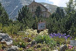
1 Schachenhaus Das oft auch als Jagdschloss Schachen bezeichnete Gebäude kann inoffiziell als das Kleinste der bayerischen "Königsschlösser" von König Ludwig II. angesehen werden. Der Schachen ist nur zu Fuß oder per MTB zugänglich.
- Jagdschloss: 1870/71 wurde das kleine Schloss unter König Ludwig II. im "Schweizer Chaletstil" erbaut. Es enthält eine aufwändige maurische Inneneinrichtung.
- Alpengarten Der Alpengarten zeigt auf über 1 ha mehr als 1000 Hochgebirgspflanzen. Neben Pflanzen aus diversen Regionen der Alpen sind auch Hochgebirgsgewächse aus Übersee wie z.B. den Rocky Mountains oder dem Himalaya zu sehen.
- Schachenhaus - Berghütte mit Gastronomie, Zimmern und Lager in den ehemaligen Wirtschaftsgebäuden;
various
2 Schloss Elmau Im Nordosten dem Wetterstein-Hauptkamm vorgelagert liegt Schloss Elmau, Nutzung als Luxushotel und Tagungsstätte. Es ist im Jahre 2015 Stätte für das international hochkarätig besetzte Gipfeltreffen der G7/G8.
activities
Wandern und Bergsteigen
Die einfacheren und mittelschweren Zustiege zu den Gipfeln des Wettersteins sind bei den Bergen und Gipfeln vor beschrieben.
Auf die Zugspitze führen mehrere Anstiege:
- von Garmisch durch das Höllental auf die Zugspitze (Gletscherbegehung und Klettersteig, langer Zustieg);
- von Garmisch durch das Reintal auf die Zugspitze (langer Anstieg);
- von Ehrwald in Nordtirol aus führen zwei Anstiege zum Gipfel der Zugspitze: Der Weg über das Gatterl (Max-Klotz-Steig) ist ein Wanderweg und führt im oberen Teil über das Zugspitzplatt, der Anstieg über die Wiener-Neustädter-Hütte ist ein Klettersteig.
Wanderwege
- The Ganghoferweg ist ein technisch leichter Wanderweg als Rundweg mit insgesamt rund drei Stunden Gehzeit im Talboden des Gaistals und mit mehreren Einkehrmöglichkeiten bei den Almen im Gaistal. Im unteren Teil auch als Winterwanderweg begehbar. Start ist der Parkplatz Salzbachbrücke in Leutasch.
- The Franzosensteig ist ein Wanderweg von Mittenwald nach Leutasch und folgt einer historischen Route der bayerisch-französischen Truppen im 3. Koalitionskrieg unter Napoleon;
- The Max-Klotz-Steig ist der Zustieg von Ehrwald über das Gatterl zum Zugspitzplatt und ein Teilstück des Anstiegs zur Zugspitze.
Fernwanderwege
- Der europäische Weitwanderweg E4 von Zypern über Bulgarien und durch die Alpen bis nach Frankreich und Spanien berührt in einer alpinen Variante die Region: Vom Karwendel aus kommend führt er über Scharnitz und das Gaistal to Ehrwald, in einer anspruchsvollen Teilvariante auch über den Zugspitzgipfel.
- Der rote Weg der Via Alpina führt in mehreren Etappen durch die Täler und Übergänge im Wetterstein: von Scharnitz above Leutasch and the Söllerpass to Meilerhütte, von der Meilerhütte über den Schachen to Reintalangerhütte und von der Reintalangerhütte über das Gatterl und das Gaistal in the Mieminger Kette to Coburger Hütte.
- The Tiroler Adlerweg ist Nordtirols bekanntester Weitwanderweg, er führt auf insgesamt 126 leichten bis hochalpinen Tagesetappen durch ganz Tirol und im Süden am Wetterstein vorbei: Die Etappe 16 führt aus Leutasch durch das Gaistal, die Almen am Talboden und über die Ehrwalder Alm und bis nach Ehrwald.
Klettersteige
Allgemeine Ausführungen zu KlettersteigenDie Klettersteige in den Anstiegen zur Zugspitze siehe bei der Besteigung der Zugspitze and vor;
Klettern

Das ganze Wetterstein ist eine Kletterregion, mit einem Schwerpunkt im zentralen Teil des Gebirges am Wettersteinhauptkamm und mit den Stützpunkten der Oberreintalhütte im Oberreintal und der Reintalangerhütte.
Mountain biking
- Mountainbiketour über Elmau auf den Schachen (auf 1885 m) - Weghinweise siehe Artikel Schachen Wetterstein
Winter sports
Skitouren
- Zur Saison 2013/2014 wurde in Mittenwald ein Skitourenlehrpfad zum Gipfel des Kranzbergs neu eröffnet.
Ski Alpin
- Einziges Skigebiet im Gebirge selber ist das Skigebiet Zugspitzplatt (2.000 m – 2.943 m) auf der Zugspitze. Deutschlands einziges Gletscherskigebiet hat Pisten überwiegend im mittleren Schwierigkeitsgrad und eine Saison von November bis Ende Mai, je nach der Witterung.
Die übrigen Skigebiete liegen am Rand des Wettersteins:
- Am Nordostrand des Gebirges und bei Mittenwald gibt es das familienfreundliche Skigebiet Kranzberg (980 m -1390 m);
- Am Nordrand in Garmisch-Partenkirchen gibt es das Skigebiet Garmisch-Classic (700 m - 2.050 m), das ist der Zusammenschluß der drei Skigebiete am Hausberg, Kreuzeck und Alpspitze für Familien und auch für sportlich ambitionierte Abfahrer.
- Im Westen in Ehrwald gibt es die beiden Ehrwalder Ski areas Wettersteinbahnen and Ehrwalder Almbahnen (1.040 - 1.320 m und 1.100 - 1.950 m), die sich mit Pisten überwiegend im mittleren und einfacheren Schwierigkeitsbereich vor allem für Familien und für Skianfänger empfehlen.
Ski nordisch

Rodeln
Von der Wettersteinhütte gibt es in den Wintermonaten eine präparierte Rodelbahn ins Gaistal hinunter.
kitchen

Bewirtschaftete Almen ohne reguläre Unterkunft (wenn nicht ausdrücklich angegeben). Auf Almen gibt es Getränke und einfache Speisen wie Brotzeiten oder auch Suppen und die Produkte der Alm.
Bergalmen und Berghütten am der Zugspitze (im Westen des Wettersteins) sind:
1 Höllentaleingangshütte, am Eingang des Höllentals;
2 Hochthörlehütte, an der sonnigen Westseite der Zugspitze über dem Eibsee;
Nordseite
Verpflegungsstationen auf der Nordseite (Werdenfelser Land) oder mit einfachstem Zugang von der Nordseite sind (von West nach Ost):
1 Hochalm (Almhütte, 1.705 m), Hochalm 1, Postfach 1106, 82491 Grainau (nördlich der Alpspitze). Tel.: 49 (0)8821 2907. Geöffnet: ganzjährig geöffnet.. Von den Bergstationen der Seilbahn auf den Osterfelderkopf (oberhalb) oder von der Kreuzeckbahn (unterhalb) jeweils in ca. 30 Minuten erreichbar
2 Partnachalm (Berggasthof, Ferienwohnungen, 1.050 m), Streichla 1, 82467 Garmisch-Partenkirchen (in der Nähe der Partnachklamm / Partenkirchen). Tel.: 49 (0)08821 2615. Geöffnet: Donnerstag Ruhetag.;
3 Bockhütte (Almhütte, 1.052 m, Partenkirchner Weidegenossen), Streichla 1, 82467 Garmisch-Partenkirchen (im mittleren Teil des Reintals). Tel.: 49 (0)8821 2615. Geöffnet: Ende Mai bis Anfang September..Eine allererste Blockhütte wurde im frühen 18. Jahrhundert von einem unbekannten Förster auf einer gezeichneten Karte als "Pochhüttl auf den Eisen Poden" erwähnt.
Die neue Bockhütte wurde 2011 eingeweiht und ersetzt die 1932 aufgestellte Holzhütte, welche sich am Schluss in einem desolaten Zustand befand. Ausgerüstet ist der technisch moderne Hüttenbau mit Photovoltaik auf dem Dach und kleinen Stromturbinen in der Partnach sowie mit einer modernen Toilettenanlage und einer biologischen Kleinkläranlage.
Einfachster Zustieg vom Skistadion in Partenkirchen und als familiengeeignete Wanderung durch Partnachklamm und Reintal in gut zwei Stunden zur Hütte.
4 Wettersteinalm (Wettersteinalpe, 1.464 m), Wettersteinalm, 82467 Garmisch-Partenkirchen (zwischen Schloss Elmau und Schachen an der Nordseite der Wettersteinwand). Tel.: 49 (0)08821 56602. Geöffnet: Anfang Juli bis September..
Einfachster Zustieg von Schloss Elmau und als familiengeeignete Wanderung in ca. 1 - 1,5 Stunden Fußweg in Richtung Schachen bis zur Alm.
Südseite
Verpflegungsstationen auf der Südseite in Tirol und im Gaistal sind:
- 5 Tirolerhaussiehe auch hier : Restaurant an der Bergstation der Ehrwalder Almbahn, ganzjährig tagsüber geöffnet.
- 6 Steinernes Hüttl (1.905m) (im Westen über dem Gaistal). Tel.: 43 (0)6642469125. einfache Almküche - eigene Produkte, Übernachtung (8 Lager) möglich .Geöffnet: je nach Witterung Anfang Juni - Ende September.
einfachster Zustieg aus Ehrwald or. Leutasch in ca. 2 bis drei Stunden durch das Gaistal, Anfahrt mit MTB bis zur Alm nicht möglich;
- 7 Rotmoosalm (2.030 m, höchstgelegene Alm über dem Gaistal), Rotmoosalm 1, 6105 Leutasch. Tel.: 43 (0)664 4226149. Ein erstes Almgebäude entstand 1900, die 1953 neu errichtete Alm wurde im Winter 2008/09 von einer Lawine zerstört, 2011 eröffnete die neue Rotmoosalm und in Lage etwas weiter oben.Geöffnet: Mitte Mai bis Mitte Oktober.
Zustieg ab Parkplatz Gaistal (1140 m) über 770 Hm in ca. zwei bis zweieinhalb Stunden;
Gipfelmöglichkeiten; Predigtstuhl, Hochwanner;

- 8 Wangalm (1.753 m, in Nähe der Wettersteinhütte und am Fuße der Gehrenspitze), 6105 Leutasch in Tirol. Tel.: 43 (0)680 5540504. Kinderspielplatz;Übernachtungsmöglichkeit: 25 Matratzenlager, 18 Zimmerlager.Geöffnet: Anfang Mai bis Mitte Oktober, kein Ruhetag.
Zustieg ab Parkplatz Gaistal (1140 m) in Leutasch in eineinhalb bis zwei Stunden.
- 9 Hämmermoosalm (1.417 m, am Ganghoferweg im Gaistal), Klamm 3, 6105 Leutasch in Tirol. Tel.: 43 (0)676 333 7 000. Geöffnet: ab ca. Mitte Dezember bis Ende März und von Mitte Mai bis Anfang November.
Zustieg ab Parkplatz Gaistal (1140 m) in Leutasch mit ca. 2,5 km Wegstrecke, dieser Zustieg ist beliebte Familienrodelbahn;
- 10 Tillfußalm (1.382 m, am Ganghoferweg im Talboden des Gaistals), Ahrn 214, A-6105 Leutasch/Tirol (im Talboden ddes Gaistals). Tel.: 43 (0)5214 6297. Geöffnet: bewirtschaftet ab Mitte Mai bis Ende Oktober, täglich von 9 bis 17 Uhr.
An der Tillfussalm befindet sich das nicht öffentlich zugängliche Ganghoferhaus, die ehemalige Jagdhütte des Heimatdichters Ganghofer.
Einfachster Zustieg aus Leutasch, Parkplatz Salzbach in ca. 1,5 Stunden.
- 11 Gaistalalm (1.366 m, am Ganghoferweg im Talboden des Gaistals), Gasse 180, A-6105 Leutasch Tirol. Tel.: 43 (0)5214 5190. Übernachtung im Lager für bis zu 15 Personen möglich. Die Hütte liegt direkt am Tiroler Adlerweg. Außerdem ist sie auch eine beliebte Station für Mountainbiker bei der Durchquerung des Gaistals.Geöffnet: Bewirtschaftet Mitte Mai bis Mitte Oktober, ab Weihnachten bis Ostern, keine Ruhetage. Im Winter nur Tagesbetrieb.
Einfachster Zustieg aus Leutasch, Parkplatz Salzbach in ca. 1,5 Stunden.
accommodation

Liste der Berghütten des deutschen Alpenvereins (DAV) und des österreichischen Alpenvereins (OeAV) sowie Privathütten für Wanderer, Bergsteiger und MTBiker (Stand März 2007).
Zugspitze
Die alpinen Unterkünfte auf der Zugspitze und an den den Anstiegen zur Zugspitze im Westen des Gebirges:
12 Münchner Haus, auf dem Westgipfel der Zugspitze und auch mit den Zugspitzbahnen leicht erreichbar;
13 Höllentalangerhütte im Höllentalanger und am Anstieg aus Hammersbach (Grainau) im Nordosten der Zugspitze;
14 Knorrhütte: östlich vom Gipfel der Zugspitze am unteren Ende des Zugspitzplatts und am Anstieg aus Partenkirchen gelegen;
15 Wiener Neustädter Hütte, westlich von der Zugspitze und am Anstieg aus Ehrwald zum Gipfel gelegen;
Diese Hütten werden im Abschnitt accommodation der Zugspitze ausführlicher behandelt.
Norden
Die alpinen Unterkünfte an der Nordseite oder mit einem Zugang von der Nordseite des Wettersteins:
16 Stuibenhütte (Selbstversorger-Hütte, 1.640 m, DAV-Sektion Garmisch), Turmackerstr. 10, 82467 Garmisch-Partenkirchen. Geöffnet: nur in der Wintersaison von Weihnachten bis Ostern.
Ausstattung: 30 Matratzenlager;
Einfachster Zustieg: Aufstieg von der Bergstation der Kreuzeckeckbahn (1.652 m) in ca. 1,5 Stunden.

17 Reintalangerhütte (1.367 m, DAV Sektion München), Postfach 1643, 82456 Garmisch- Partenkirchen (im Reintal). Tel.: 49 (0)8821 708 97 4. Geöffnet: Mitte Mai bis Ende Oktober. Die Hütte ist familienfreundlich, auch wegen gefahrlosen Zustiegs durch das Reintal.
Ausstattung: 20 Betten, 70 Matratzenlager, getrennte Waschräume jeweils mit Dusche, Toiletten, Winterraum mit 15 Lagern (AV-Schloss).
Einfachster Zustieg: Vom Skistadion in Partenkirchen (ca. 700 m) durch die Partnachklamm und das Reintal in ca. 4 - 5 Std.; from Kreuzeckhaus ca. 4 1/2 Std. Die Hütte ist auch beliebte Endstation für Mountainbiketouren ins Reintal.
Seit der Herbstsaison 2009 ist die Hüttenwirtlegende Charly Wehrle (siehe auch unter literature) im wohlverdienten Ruhestand, Nachfolger als Hüttenwirt ist sein bisheriger Partner Simon Neumann. Die frühaufstehenden Hüttengäste müssen aber auch unter dem neuen Hüttenwirt auf den traditionellen musikalischen Weckruf nicht verzichten, ebensowenig auf die gelegentliche abendliche Hausmusik.
18 Oberreintalhütte (Franz-Fischer-Hütte, 1.525 m, DAV Sektion Garmisch-Partenkirchen). Tel.: 49 (0)8821 2701. Geöffnet: Mitte Mai bis Mitte Okt., je nach Witterung; im Winter nicht zugänglich.. Erbaut wurde die Oberreintalhütte von 1921 bis 1922, sie ist vor allem ein Stützpunkt für Klettertouren in den steilen Wänden des Oberreintals. Auf der im Sommer bewarteten Selbstversorgerhütte werden Getränke (Tee, Wasser, Kaffee, Bier) verkauft, Essen muss selbst mitgebracht werden.
Ausstattung: 50 Schlafplätze im Matratzenlager, 10 Notlager. Auf der urigen und ursprünglichen Hütte gibt es mittlerweile Strom von der Sonne und eine Komposttoilette.
Einfachster Zustieg: Vom Skistadion in Partenkirchen (ca. 700 m) durch die Partnachklamm und das Reintal weiter in das Oberreintal und in ca. 4 - 5 Stunden zur Hütte.

19 Kreuzeckhaus (Adolf-Zoeppritz-Haus, 1.652 m), Am Kreuzeck 1, 82467 Garmisch-Partenkirchen (auf dem Kreuzeck südlich von Garmisch). Tel.: 49 (0)8821 2202. Geöffnet: Mitte Mai bis Anfang November, Mitte Dezember bis Mitte April.

Ausstattung: 58 Zimmerlager, 43 Schlafplätze im Matratzenlager, Waschräume und Duschen;
Zustieg: Wegen der Lage unmittelbar an der Bergstation in der Regel Auffahrt mit der Kreuzeckbahn aus Garmisch.
Tourenmöglichkeiten: Alpspitze (2628 m) und Abstieg ins Höllental.
20 Schachenhaus To the Schachenhaus (1.880m, 47° 25′ 9″ N11° 6′ 47″ O), Berggasthaus und Unterkunft für bis zu 80 Personen, siehe beim Schachen.

21 Meilerhütte (2.372 m, DAV Sektion Garmisch-Partenkirchen), Meilerhütte 1, 82467 Garmisch-Partenkirchen (im Dreitorspitzgatterl oberhalb des Schachens). Tel.: 49 (0)171 5227897. Geöffnet: Mitte Juni bis Anfang Oktober..

Erbaut wurde die Hütte von Leo Meiler und nach der Fertigstellung im Jahre 1898 an die eigentlich hüttenfeindliche Sektion DAV Bayerland verschenkt. Die Sektion war erst kurz zuvor im Dezember 1895 als eine Abspaltung der Sektion München gegründet worden, die Gründungsmitglieder lehnten damals das neu und touristenfreundlich gebaute Münchner Haus auf der Zugspitze ab. Bewirtschaftet wurde die Hütte erst ab den Jahren 1910/1911 mit einem einfacheren Zugang nach der Fertigstellung des Fahrwegs zum Schachen. Nach dem Zweiten Weltkrieg gab dann die Sektion Bayerwald die Meilerhütte, auch vor dem Hintergrund hoher Kosten für die anstehenden Sanierungen, an den Garmischer Alpenverein ab.
Ausstattung: 11 Schlafplätze im Zimmerlager, 70 Schlafplätze im Matratzenlager; Handy-Empfang ist möglich;
Einfachster Zustieg: Von Elmau auf dem beschilderten Fahrweg über das Schachenhaus, ca. 5 Std; oder aus dem Partnacher Skistadion (Höhe: ca.740 m) durch die Partnachklamm und dann wahlweise über den Kälbersteig oder durch das Reintal in ca. 5 Stunden auf langen Zustiegen zur Hütte.
Tourenmöglichkeiten: Partenkirchner Dreitorspitze (Hermann-von-Barth Weg, leichter Klettersteig), Törlspitzen, Musterstein, Frauenalplkopf.
Süden

Die alpinen Unterkünfte an der Südseite des Wettersteins über dem Gaistal:
22 Wettersteinhütte (1.717 m, Privathütte), Waidach 293, A-6105 Leutasch (über Leutasch und über dem Gaistal im Südosten des Wettersteins). Tel.: 43 (0)660 3462100. Geöffnet: Anfang Juni bis Oktober und Ende Dezember bis Ostern (im Winter nur Tagesbetrieb).
Ausstattung: 35 Lager
Zustieg: von Oberleutasch (Klamm) 570 mH, ca. 1 1/2 Std.; vom Kirchplatzl im Leutaschtal über Forststraße auch mit dem MTB erreichbar (17 km / 500 mH/ ca.: 1,5 h).
Tourenmöglichkeiten: Klettertouren im Oberreintal, Predigtstuhl (2234 m);
23 Erinnerungshütte (2.099 m, AAVM Akademischer Alpenverein München) (etwas über dem Leutaschjoch im Südosten des Wettersteins). Selbstversorgerhütte nur für die Mitglieder des Vereins, Hütteschlüssel erforderlich. Die Hütte hat Bedeutung als Stützpunkt für die Kletterrouten an den Südwanden von Scharnitzspitze und Schüsselkarspitze.
Biwakschachteln


Notunterkünfte und Unterstandshütten mit vier Wänden und einem Dach, i.d.R. keine weitere Ausstattung und Infrastruktur.
24 Jubiläumsgrat-Biwakschachtel (2.684 m) (auf dem Jubiläumsgrat als Verbindungsgrat von der Zugspitze zur Alpspitze, östlich von der Äußeren Höllentalspitze).
25 Arnspitzhütte (1.930 m,) (südöstlich unterhalb des Gipfels der Großen Arnspitze). ganzjährig offene, neue und kleine Notunterstandshütte mit Kochnische und ohne Bewartung.: 4 Notlager (Bänke);
26 Schüsselkarbiwak (2.536 m). 6 Notlager., Notunterkunft für die Kletterer an der Schüsselkarspitze;
climate
Das Klima im Wetterstein ist bestimmt von den atlantischen Tiefdruckzonen: Das Gebirge ist das höchste Hindernis und sorgt für die bei Westlage heranziehenden Tiefs für einen Wolkenstau an der Nordseite und ergiebige Niederschläge, je nach der Jahreszeit und Tagestemperatur als Regen oder Schnee. Die meisten Niederschläge fallen dabei im Winter und im Frühjahr, die trockeneren Monate sind die im Herbst. Mit der Höhenlage steigt auch die Niederschlagsmenge.
The Klimazonen im Wetterstein reichen von den gemäßigten Bereichen in den windgeschützten Alpentälern bis in extreme Bereiche in fast dreitausend Metern Höhe: die mittlere Tagestemperatur in Garmisch-Partenkirchen liegt noch bei rund 12°C, auf der Zugspitze liegt sie bei -2°C. Die Zugspitze hält auch den Deutschen Rekord der höchsten Windgeschwindigkeit (Böen): am 12.06.1985 wurden 335 km/h gemessen.
Wie der Name schon andeutet, ist das Wetterstein im Sommer berüchtigt für seine schnell aufziehenden und schweren Gewitter, einhergehend mit Sturmböen, Starkregen und auch im Sommer möglichem Schneefall in den Hochlagen. Wegen der langen und tiefeingeschnittenen Täler können diese Gewitter oft erst sehr spät erkannt werden. Da die Gewittergefahr zum Mittag und Nachmittag stark zunimmt, ist bei Gewitterneigung unbedingt eine entsprechend angepasste Terminplanung erforderlich.
| Klima in Garmisch-Partenkirchen | Jan | Feb | Mrz | Apr | Mai | Jun | Jul | Aug | Sep | Okt | Nov | Dez | ||
|---|---|---|---|---|---|---|---|---|---|---|---|---|---|---|
| Mittlere höchste Lufttemperatur in °C | 2.1 | 4.6 | 8.3 | 12.3 | 16.9 | 19.6 | 21.8 | 21.1 | 18.8 | 14.5 | 7.4 | 2.0 | Ø | 12.5 |
| Mittlere tiefste Lufttemperatur in °C | -6.5 | -5.1 | -2.3 | 1.4 | 5.3 | 8.6 | 10.5 | 10.3 | 7.7 | 3.4 | -1.5 | -5.7 | Ø | 2.2 |
| Niederschläge in mm | 84.7 | 76.8 | 85.9 | 100.1 | 130.8 | 174.3 | 175.4 | 171.6 | 77.1 | 88 | 80 | 91.5 | Σ | 1336.2 |
| Regentage im Monat | 16 | 15 | 15 | 16 | 17 | 19 | 18 | 18 | 14 | 13 | 14 | 15 | Σ | 190 |
| Relative Feuchte in % | 84 | 81 | 78 | 75 | 75 | 76 | 77 | 81 | 85 | 82 | 84 | 86 | Ø | 80.3 |
| Sonnenscheindauer pro Tag | 2.4 | 3.3 | 4.4 | 4.8 | 5.5 | 5.5 | 6.5 | 6.2 | 5.7 | 4.9 | 2.7 | 1.9 | Ø | 4.5 |
Quelle:Wetterkontor | ||||||||||||||
| Klima der Zugspitze | Jan | Feb | Mrz | Apr | Mai | Jun | Jul | Aug | Sep | Okt | Nov | Dez | ||
|---|---|---|---|---|---|---|---|---|---|---|---|---|---|---|
| Mittlere höchste Lufttemperatur in °C | -8.6 | -8.7 | -7.5 | -4.6 | 0.0 | 2.8 | 5.1 | 5.1 | 3.2 | 0.4 | -4.6 | -7.1 | Ø | -2 |
| Mittlere tiefste Lufttemperatur in °C | -13.6 | -13.8 | -12.6 | -9.9 | -5.4 | -2.4 | -0.1 | 0.0 | -1.8 | -4.3 | -9.5 | -12.3 | Ø | -7.1 |
| Niederschläge in mm | 189 | 154 | 186 | 199 | 172 | 185 | 183 | 170 | 115 | 109 | 158 | 184 | Σ | 2004 |
| Regentage im Monat | 16 | 14 | 16 | 16 | 16 | 18 | 17 | 16 | 12 | 10 | 13 | 15 | Σ | 179 |
| Relative Feuchte in % | 77 | 77 | 80 | 86 | 88 | 91 | 88 | 87 | 81 | 71 | 75 | 74 | Ø | 81.3 |
| Sonnenscheindauer pro Tag | 3.8 | 4.3 | 5.0 | 4.9 | 5.3 | 4.9 | 5.6 | 5.8 | 5.9 | 6.1 | 4.3 | 3.7 | Ø | 5 |
Quelle:Wetterkontor | ||||||||||||||
literature

- : Wetterstein und Ammergauer Alpen, 60 Gipfeltouren, Höhenwege, Klettersteige. München: Bruckmann, 2007, Tourenführer, ISBN 978-3-7654-4475-3 ; 192 Seiten. 19,90 €
- : Wetterstein mit Mieminger Kette. München: Rudolf Rother, 1994 (7. überarbeitet), ISBN 3-7633-3129-8 ; 256 Seiten (deutsch).
- ; Deutscher und Österreichischer Alpenverein (Ed.): Alpenvereinsjahrbuch "Berg 2009". München: DAV, 2009, ISBN 978-3937530291 ; 320 Seiten. Gebietsthema Wettersteingebirge: "Der Bau des Höllentalklammwegs 1902-1905"; "Schüsselkar - neue (Routen-)Namen, neues Klettern; Schüsselkar-Südwand: Spiegelbild der Kletterkunst; Klettern im Oberreintal 1979 - 1984;
- ; Deutscher und Österreichischer Alpenverein (Ed.): Alpenvereinsjahrbuch "Berg 92"; Bd.116. München: Bergverlag Rother, 1992, ISBN 3763380558 ; 288 Seiten. Gebietsthema Wettersteingebirge / Mieminger Gebirge
- : Weckruf im Wetterstein. Panico-Verlag, 2009, ISBN 978-3-936740-59-2 ; 160 Seiten. 19,80€
- : 25 Jahre Hüttenwirt im Wetterstein. Panico-Verlag, ISBN 3-936740-20-8 ; 648 Seiten. 19,80€
- : Das Reintal: Der alte Weg zur Zugspitze. Panico-Verlag, 2010, ISBN 978-3936740011 ; 238 Seiten. 19,80€
- siehe auch Artikel Bergsteigen - Enthält auch wichtige Infos zu Thema Bergwandern
cards

Für Wanderer und Radwanderer:
- WK 322, Wetterstein - Karwendel - Seefeld - Leutasch - Garmisch-Partenkirchen - M 1:50 000. 2013, Freytag & Berndt Wanderkarten, ISBN 978-3850847483 . 8,99 €
Für Wanderer und Bergsteiger:
- Deutscher Alpenverein (DAV) (Ed.): Nr. BY 8 (1:25.000) Wettersteingebirge, Zugspitze. 2010, Alpenvereinskarte Bayerische Alpen, ISBN 9783937530406 . 9,80 €.
- Deutscher Alpenverein (DAV) (Ed.): 04/1 Wetterstein, Mieminger Gebirge. 2009 (5. Auflage), DAV Alpenvereinskarte 1:25.000, ISBN 978-3928777193 . 9,80 €.
- Deutscher Alpenverein (DAV) (Ed.): 04/2 Wetterstein, Mieminger Gebirge. 2007 (5. Auflage), DAV Alpenvereinskarte 1:25.000, ISBN 978-3928777209 . 9,80 €.
- Deutscher Alpenverein (DAV) (Ed.): 04/3 Wetterstein, Mieminger Gebirge. 2011 (6. Auflage), DAV Alpenvereinskarte 1:25.000, ISBN 978-3928777117 . 9,80 €.
Web links
- Landkreis Garmisch-Partenkirchen: www.lra-gap.de, Infobroschüre: pdf;
- Tourismus-Service-Zugspitzland: www.zugspitzland.de (Oberbayern);
- Tourismusverband Tiroler Zugspitz Arena;
- grenzüberschreitend über das Wettersteingebirge: www.wettersteingebirge.com
- ↑Partnachklamm Zugspitze - das offizielle Stadtportal für München Abschnitt Öffnungszeiten