
The Werdenfelser Land lies in the Bavarian Alps in Upper Bavaria in Germany.
places
in the Loisach valley:
- Grainau (750 m), Zugspitzdorf and high altitude health resort;
- Garmisch-Partenkirchen: 700-800 m; Health resort and international tourism and winter sports center;
- Farchant (672 m), holiday village;
- Oberau (659 m): Tourist community in the Loisach valley.
- Eschenlohe (640 m), holiday community on the Loisach;
- Ohlstadt (665 m), mountain village on the Loisach at the foot of the home garden.
east of the Loisach / on the Isar:
- Mittenwald (913 m), violin maker and climatic health resort, tourist center at the foot of the western Karwendelspitze;
- Krün (875 m), agriculture and tourism, with the district of Klais;
- Wallgau (866 m), tourist community on the Isar;
west of the Loisach:
- Murnau am Staffelsee (650-730 m) at the Staffelsee, art (the blue rider) and tourism;
- Seehausen on the Staffelsee (655 m), fishing village on the eponymous lake.
west of the Loisach and in Ammergau
- Oberammergau (837 m), Schnitzerdorf, Lüftlmalerei and world-famous Passion Play location;
- Unterammergau (836 m), Lüftlmalerei and holiday community in the Ammertal;
Other goals
background

The Werdenfelser Land, also known as the "Goldenes Landl", is geographically the region between Garmisch-Partenkirchen and Mittenwald, historically named after the region that fell into disrepair since the 17th century Werdenfels Castle (the county of the same name) north of Garmisch-Partenkirchen. The function of this eponymous castle was to secure the once important trade route from Italy through the Loisach Valley to Upper Bavaria;
Today, the term "Werdenfelser Land" means the alpine picture-perfect holiday landscape with the river valleys of the Loisach, the upper Isar and the upper Ammer at the foot of the high mountain regions of Wetterstein and Karwendel.
little chronicle
The first traces of human settlement in the region can be traced back to the Neolithic Age, and as a result the region has always been important due to its location on the route from Italy to the Danube.
In Roman times there are various travel stations on the Roman road Via Claudia, an example is "Partanum" in place of today's Partenkirchen
The settlement of the Loisach valley by the Bavarians is then dated to the 7th century.
In 1294 the entire county of Werdenfelser Land became the property of the bishopric Freising over, it can for a long time to come under the influence of the Wittelsbachers (in Munich and Ingolstadt resident) withdraw.
The region experienced a heyday in the High Middle Ages: the Fuggers had settlements on the trade route from augsburg to Italy (Example is Partenkirchen), rafting is also very important: on the Isar and Loisach, wood and important commercial goods are transported north.
During the Thirty Years' War (1618 to 1648) the whole area became impoverished, and the region suffered heavily from the Spanish and Austrian Wars of Succession and the Napoleonic Wars in the 18th century.
In 1802, the county of Werdenfels became part of Bavaria in the course of secularization.
It was not until 1826 that the municipality of Oberammergau was assigned to the Werdenfels regional court and thus to the Werdenfelser Land; the municipality previously belonged to the Schongau regional court.
Tourism began in 1889 with the completion of the rail link from Garmisch-Partenkirchen to Munich.
Lüftlmalereien


The Lüftlmalerei is a facade painting in fresco form, which can be seen in the entire region in many examples. Religious and folk motifs are depicted as picture stories, or topics relating to the homeowner's trade.
The origin of the name is no longer clearly verifiable: On the one hand, a Josef Lüftl is listed as the first representative of the art form, the location of the studio at "lofty heights" is mentioned on various occasions, and "Haus zum Lüftl" is also mentioned in Oberammergau listed as eponymous.
The origins of Lüftlmalerei can be traced back to Italian monumental art in the Renaissance and Baroque periods, which were "brought in" due to the immediate location of Werdenfelser Land on the trade route to Italy. The development of material technology in the 18th century then enabled the paintings to be permanent and weatherproof: the colors are applied to the still wet and fresh (al fresco) lime plaster in one day so that the paint can penetrate deep into the still damp mortar. It is therefore necessary for the artist to work quickly and confidently. Burnt (slaked lime: non-carbonated) is used, which is responsible for the white base color, and only on it the crystalline water-insoluble lime layer forms on the surface with the carbonic acid from the air, which protects the water colors used from fading and for the preservation of the rich color tones is responsible.
The Lüftlmalerei quickly developed into a new folk art and also a status symbol for homeowners, the Lütlmalerei spread from Oberammergau, Mittenwald and Garmisch-Partenkirchen across the entire Alpine region.
The most important representative of the new art was Franz Seraph Zwinck, born in Oberammergau in 1748, he lived in the aforementioned house "Zum Lüftl" in Oberammergau. Other important artists were Franz Karner (from Mittenwald) and Heinrich Bickel (from Garmisch-Partenkirchen), the painter is no longer known today for many historical and "unsigned" paintings. Modern artists include: Gerhard Ester, Garmisch, and Sebastian Pfeffer, Mittenwald.
- : Lüftlmalerei on the Isar, Partnach, Loisach and Ammer. Media publishing house Schubert, 2003, ISBN 3-929229-92-7 ; 96 pages.
- : Lüftlmalerei. Freilassing: Pannonia Publishing House, 1981 (2nd edition), Small Pannonia range, ISBN 3-7897-0061-4 ; 48 pages.
- Further Info at www.garmisch-partenkirchen.de/ and at wikipedia.
Maschkera
The Maschkerra and the "Maschkeragehen" are an old pagan custom in the Werdenfelser Fosanacht: wild figures with wooden masks roam the streets with a racket and noise. The whole thing only takes place on certain days of the week: Sunday, Monday, Tuesday and Thursday. The highlights are then the nonsensical Thursday, Fosnacht Sunday and Fosnacht Tuesday.
Figures are for example the Krätznweiblan, the Untersberger Mandln, the Pfeifermandl, the Jacklschutzen or the Biggalan. The mask wearers must not be recognized under any circumstances, so they exchange wooden masks with one another.
Side to Carnival in Werdenfelser Land.
language
getting there
By plane
The nearest major international airport is that Munich Airport![]()
![]()
![]()
![]() (IATA: MUC), Distance about two hours by car). As the second largest airport in Germany, it is connected to a large number of cities.
(IATA: MUC), Distance about two hours by car). As the second largest airport in Germany, it is connected to a large number of cities.

The can also be reached quickly Innsbruck airport![]()
![]()
![]()
![]() (IATA: INN), approx. a good hour's drive).
(IATA: INN), approx. a good hour's drive).

in the street
- from the north (Munich): on the Federal motorway 95 (Munich - Garmisch) to the end of the motorway at Eschenlohe, and continue on the B2 federal road.
- from the south (Austria): From the A12 (Inntalautobahn), exit Zirl / West (west of Innsbruck), over the Zirler Berg;
by train
The stations of Murnau, Eschenlohe, Oberau, Garmisch-Partenkirchen, Krün (Orteil Klais) and Mittenwald are on the railway line Munich (Starnberg wing station) - Garmisch-Partenkirchen - innsbruck with hourly connection in both directions.
ICE direct connections exist with the ICE Wetterstein to DortmundCologne and Frankfurt am Main, with the ICE Werdenfelser Land to Lübeck, Hamburg, Hanover, Goettingen, and Fulda, with the ICE Zugspitze to Bremen and with that ICE Karwendel to Berlin and Leipzig. The cities Nuremberg, Ingolstadt and Munich stop for all of the aforementioned ICE trains.
mobility
- The RVO (Regionalverkehr Oberbayern / DB) operates the bus routes in the region;
- Regionalverkehr Oberbayern GmbH, Hirtenstrasse 24, D-80335 Munich; Tel .: 49 / (0) 89 / 55164-0, Fax: 49 / (0) 89 / 55164-199; info;
Tourist Attractions
Churches
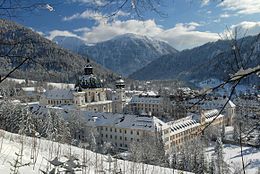
The most important monastery in the region is the tourist magnet Ettal Monastery in the Ammergau Alps, the location of the historical Klosters in solitude near Scharnitz is no longer known today, a position is assumed north of Scharnitz in the area at Mittenwald / KlaisThe founding of the monastery is documented for the year 763.
Castles, chateaus and palaces
The ruin derives from the name of the entire region Werdenfels Castle near Burgrain north of Garmisch, the modern one Elmau Castle a hotel can be reached from Krün.
Museums
Supraregional The expessionist collections in Murnau are important Castle Museum and the Münter House.
Museums on special topics are:

- In Mittenwald the Violin making museum, the Wolpertinger Museum and the Schnapps Museum;
- In Garmisch-Partenkirchen the Aschenbrenner Museum, a collection of china, dolls and cribs that Michael Ende exhibition on the life and work of the writer and the collection in Richard Strauss Institute to the composer's life.
- In Oberammergau is that Oberammergau Museum, a collection of reverse glass paintings with a nativity museum. There is also the private collection of the Model bus museum.
- There is also one in Oberau Nativity Museum.
Local museums are in Garmisch-Partenkirchen the Werdenfelser Heimatmuseum on civil and rural culture in the former Freisingische Grafschaft Werdenfels. There is one in Ohlstadt Village museum.
Lakes and bodies of water
The two most important Rivers in Werdenfelser Land are in the east Isar in the upper Isar valley from Mittenwald to Krün and the Loisach in the Loisach valley from Grainau to Ohlstadt. In the northwest of the region runs the valley of the Bunting.
A lake landscape, among other things with Ferchensee and Lautersee and also with bathing facilities, is located west of Mittenwald.
Staffelsee

The Staffelsee has an area of 7.7 km², 4.3 km in length and 1.78 km in width and is on average about 9.80 meters deep, the maximum depth is 42 meters. The lake has a shore length of 19.3 km and seven islands, it is one of the most beautiful and idyllic alpine lakes in Bavaria. Because of the moor-rich water, the lake is warm above average.
The lake has several islands, the largest and only one being populated Wörth Island. According to archaeological finds, the first settlement of Wörth is dated to the Bronze Age, the settlement was fortified in late antiquity. At the end of the seventh century a mansion with a church was built on the island and a monastery in its place in the eighth century. The monastery church was the parish church for until the 18th century Seehausen and was then canceled. Today's parish church of St. Michael in Seehausen on the mainland was built from the quarry stones.
There is an archeology park on the island of Wörth.
- Round trip Staffelseeschiffahrt: Duration approx. 80 min; Price adults: 8.- €; Travel times; Daily from 10 a.m. every 80 minutes from April to All Saints' Day;
- Staffelsee Motorschiffahrt OHG, Im Hinterfeld 8; 82418 Seehausen am Staffelsee;
- Tel. 08841/62 88 33; Staffelseeschifffahrt;
- Camping island Buchau, Campsite, is approached by the Staffelseeschifffahrt;
- Boat rental: Rowing boats, pedal boats and electric boats;
Riegsee
Froschhauser See
Murnau moss
With an area of 32 km², the wetland is the largest contiguous and deepest moorland in Central Europe. It emerged from a lake in the bed of the Loisach glacier after the end of the last ice age. Today it is a nature reserve with a rich fauna and flora such as many species of orchids, cotton grass, corncrake, white-backed woodpecker and adder.
activities
- To is considered to be particularly atmospheric Corpus Christi the only Bavarian lake procession in Seehausen on the Staffelsee and with boats and barges on the Staffelsee.
winter
Alpine skiing
Lift systems with ski areas in Werdenfelser Land are:
- In Garmisch-Partenkirchen the Alpspitzbahn, Kreuzeckbahn and of course the train on that Zugspitze with the ski area on the Zugspitzplatt.
- in the Mittenwald there is that Kranzberg ski area and the Dammkar ski area.
- In Oberammergau brings the Laber mountain railway and the Piston chairlift Ski fans to the top.
In the south-west of the Werdenfelser Land Except far are located in Ehrwald and Biberwier also quickly accessible ski areas.
Further information For ski areas see also in the article Winter sports in the Bavarian Alps;
kitchen
Murnau-Werdenfelser beef
The "MW-Rind", also "Oberländer", "Murnauer" or "Rote", originated at the end of the 19th century from crosses of the Oberinntaler and the Graubünden gray cattle, the Allgäu and Swiss Brown cattle, as well as the Mürz valley, Murboden and Ellinger cattle. At the beginning of the twentieth century, the rather petite breed was in decline and its population was at risk; since the end of the Second World War, breeding has been promoted again and takes place in its pure form and with a focus on its original breeding area. The robust breed is characterized by a good adaptation to moor and swamp landscapes and a high longevity, it is considered the only native cattle breed in Bavaria.
The milk of the cows is important for the consumer, the unique composition of milk proteins is the basis for particularly tasty cheese specialties. The aromatic meat of the animals is characterized by its curvature and tenderness. Products made from Werdenfels beef (cheese, meat, sausages) are increasingly being marketed in the region and also nationwide as high-quality organic products, but because of the overall low animal population (only around 50 breeders), the products are still something special.
nightlife
- Offers the largest selection of evening entertainment options Garmisch-Partenkirchen, there are numerous pubs, discos and even a casino in the village.
- There is also a noteworthy range of pubs and music venues in Mittenwald and in Murnau.
- theatre in Werdenfelser Land are in Garmisch-Partenkirchen the Peasant theater and the Small Theater Partenkirchen.
security
- Alpine Club - Weather service;
- Avalanche warning service for Bavaria.
- Avalanche warning service for Austria
climate
| Climate in Garmisch-Partenkirchen | Jan | Feb | March | Apr | May | Jun | Jul | Aug | Sep | Oct | Nov | Dec | ||
|---|---|---|---|---|---|---|---|---|---|---|---|---|---|---|
| Mean highest air temperature in ° C | 2.1 | 4.6 | 8.3 | 12.3 | 16.9 | 19.6 | 21.8 | 21.1 | 18.8 | 14.5 | 7.4 | 2.0 | O | 12.5 |
| Mean lowest air temperature in ° C | -6.5 | -5.1 | -2.3 | 1.4 | 5.3 | 8.6 | 10.5 | 10.3 | 7.7 | 3.4 | -1.5 | -5.7 | O | 2.2 |
| Precipitation in mm | 84.7 | 76.8 | 85.9 | 100.1 | 130.8 | 174.3 | 175.4 | 171.6 | 77.1 | 88 | 80 | 91.5 | Σ | 1336.2 |
| Rainy days in the month | 16 | 15 | 15 | 16 | 17 | 19 | 18 | 18 | 14 | 13 | 14 | 15 | Σ | 190 |
| Relative humidity in% | 84 | 81 | 78 | 75 | 75 | 76 | 77 | 81 | 85 | 82 | 84 | 86 | O | 80.3 |
| Length of sunshine per day | 2.4 | 3.3 | 4.4 | 4.8 | 5.5 | 5.5 | 6.5 | 6.2 | 5.7 | 4.9 | 2.7 | 1.9 | O | 4.5 |
Source:Wetterkontor | ||||||||||||||
literature
- ; House of Bavarian History (Ed.): Garmisch-Partenkirchen and Werdenfelser Land. augsburg: Blow, F., 2010, EDITION BAVARIA 04, ISBN 978-3791722689 ; 88 pages. Price: 8 €
- : Werdenfelser Land: Garmisch-Partenkirchen, Mittenwald, Oberammergau. Rosenheim publishing house, 2005, ISBN 978-3475536762 ; 95 pages.
- : Legends and legends about Werdenfelser Land and Pfaffenwinkel, Mittenwald, Partenkirchen, Garmisch, Ettal. Ambro Lacus, 2008, ISBN 978-3-921445-33-4 ; 292 pages.
cards
- Bavarian Land Surveying Office, sheet UK L 31, 1:50 000; ISBN 3-86038-509-7 ;
Web links
- District of Garmisch-Partenkirchen: www.lra-gap.de, Information brochure: pdf
- Tourism Service Zugspitzland: www.zugspitzland.de;
- Tourist info Werdenfelser Land: www.habenfelserland.de;
- Tourism Association Upper Bavaria: www.oberbayern-tourismus.de - supraregional;
- Tourist info: www.dasblaueland.de;
