 | ||
| Walchensee | ||
| federal state | Bavaria | |
|---|---|---|
| Residents | unknown | |
| no value for residents on Wikidata: | ||
| height | 800.8 m | |
| no tourist info on Wikidata: | ||
| location | ||
| ||

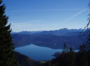
The Walchensee is on the edge of the Isarwinkel in Upper Bavaria. The climatic health resort Walchensee lies on the west bank.

background
The Surname Walchensee can be documented in the 11th century as Walhense, in 1441 as Walchensee and 1698 as Wallersee, it is derived from the Middle High German name for the Walchen, that was the population with Romanesque origin south of the Alps, which after the departure of the Romans remained in southern Bavaria in the 5th century.
The Settlements on the Walchensee were fishing villages and belonged to the monasteries Benediktbeuern (the western shore of the lake with the place Walchensee) and Schlehdorf, The ownership claims of the Koster Benediktbeuern are already documented for the year 740. The Walchensee remained, with changing ownership, in the property of the monasteries until the secularization in 1803, the lake itself is now the property of the Free State Bavaria.
Was an important guest of the region J. W. von Goethewho repeatedly stopped at Walchensee on his trips to Italy (1786 and 1790) and also noted the lake and the duke's estate in his sketchbook.
Another important regular guest in the region was Lovis Corinth, he stayed in Urfeld every summer (1918-1925). The region was for the East Prussian Tapiau native painter and important representative of German Impressionism a retreat in old age, this is where his famous late work, the Walchensee pictures, was created, which also became the artist's greatest economic success. The painter's house is now privately owned.
Walchensee - place

Politically, the place Walchensee is a part of the municipality Kochel am See.
The hamlet Hermitage is at the southwest end of the lake, the village Urfeld on the north shore of the lake.
The hamlet of Zwergern (Klösterl Walchensee) is located on a peninsula on the western bank of the Walchensee.
The hamlets of Altlach, Niedernach and Sachsenbach are located on the south, south and east banks of the Walchensee, and they are already part of the municipality Jachenau.
Walchensee - lake
The Walchensee owes its creation to a tectonically conditioned depression and is one of the oldest lakes in Germany, it thus differs from the neighboring lakes in the foothills of the Alps, which owe their creation to the erosion of the glaciers in the Ice Age and therefore not nearly as deep and also very much are younger.
The lake is extremely rich in fish and species, examples of the stocking are char, whitefish, eel, pike, tench, bream, roach, aitel, arbor, minnow, barbel, perch, and also the crayfish. Many species were also used from the Middle Ages. She is considered the queen of Walchensee Lake trout allegedly weighing up to 60 pounds. However, humans have to help with rearing, as the spawning is disturbed in its natural migration.
The water of the lake is nutrient-poor and very clear, it has drinking water quality, the entire Walchensee including its shores is a landscape protection area.
The Walchensee power plant was created from 1918 to 1924 immediately after the end of the First World War: The water of the Isar is from Krüner Isar reservoir diverted to the Walchensee as the "upper basin" and the difference in altitude to the 200 meters lower Kochelsee lake is used as the "lower basin" by the storage power plant to generate electricity.

| Lake data: | ||
|---|---|---|
| Surface: | 16.267 km² | |
| Volume: | 1,324,000,000 m³ | |
| Scope: | about 27.0 km | |
| Wide length: | approx. 5.0 / 6.7 km | |
| Depth (medium / max): | 81.4 / 192.3m | |
| Height above NN: | 800.8 m |
getting there
| Distances (road km) | |
| Krün | 11 km |
|---|---|
| Kochel am See | 14 km |
| Mittenwald | 19 km |
| Garmisch | 29 km |
| Lenggries | 34 km |
| Bad Tölz | 40 km |
| Tegernsee | 57 km |
| innsbruck | 58 km |
| Munich | 85 km |
By plane
- The nearest major international airport is the airport Munich - Franz Josef Strauss (131 km, approx. A good hour's drive). From here, among others, offer Lufthansa and their partner the Star Alliance Connections to cities in Germany, Europe and worldwide. As the second largest airport in Germany, it is connected to a growing number of cities.
- The airport in can also be reached quickly innsbruck (56 km, about an hour's drive);
By train
- The nearest train station is in Kochel am See from here hourly rail connection to Munich, change in Tutzing to DB route no. 961 to Kochel (approx. 1.06 hours from Munich). From Kochel to Walchensee by bus or taxi.
- Further train stations are located in Mittenwald and in Klais (16 km, district of Krün) on the railway line Munich (Starnberg wing station) - Garmisch-Partenkirchen - innsbruck, both are stops for Intercity.
- Timetable information from train;
In the street
- The Bundesstrasse 12 leads, from south out Mittenwald coming over Krün and Wallgau along the west side of the Walchensee.
- Of north is the approach via the Autobahn A95 Munich - Garmisch-Partenkirchen,
 Kochel, and further about Großweil, Schlehdorf, and from Kochel am See (Bundesstrasse 12) possible over the Kesselberg to Walchensee;
- At the South side of the lake leads a (toll route, daily fee 3.- €) to the east through the Jachenau onto Bundesstrasse 13 and after Lenggries.
- The northeast side of the lake is closed to road traffic.
- The Walchensee is located on the German Alpine Road
mobility
- the RVO (Regionalverkehr Oberbayern / DB) operates the bus routes in the region;
- Regionalverkehr Oberbayern GmbH, Bad Tölz base; Im Farchet 22, 83646 Bad Tölz; Tel.:08041 / 9655; www.rvo-bus.de;
Tourist Attractions

- 1 Walchensee Museum, Urfeld 1, 82432 Walchensee, Germany (in Urfeld in the former Hotel Post).

 in the Wikidata database") Local history collections, special exhibitions.Open: May 1st to October 25th, Fri. to Sun. 10.30 a.m. - 5 p.m.Price: Adults: 5.- €.
Local history collections, special exhibitions.Open: May 1st to October 25th, Fri. to Sun. 10.30 a.m. - 5 p.m.Price: Adults: 5.- €.
- Former Klösterl Walchensee with St. Anna's chapel, which is well worth seeing, can only be visited on Sundays;
- Location: in the hamlet of Zwergern on the south-west bank of the lake.
- Goethe monument, erected in 1932 on the occasion of the 100th anniversary of the death of the poet and guest at the lake, located on the last serpentine of Kesselbergstrasse.
activities
- In Einsiedl at the south-western end of the lake (towards Mittenwald): bathing beach, boat rental (pedal boats and rowing boats), diving school and bike rental.
- Walchensee triathlon
- 1 Herzogstandbahn, Am Tanneneck 6, 82432 Walchensee. Tel.: 49 (0)8858 236. The cable car takes you from Walchensee (809 m) to the Fahrberg (1,600 m), a pre-summit of the mountain, in four minutes Herzogstands.Open: from Christmas to mid-NovemberPrice: ascent and descent adults € 11.50 (€ 6.70 one way).
surfing
- For surfer the Walchensee is considered to be one of the very best that the Bavarian Alps have to offer, so the rush in summer is accordingly.
With a cloud-free sky and large air currents from the north or north-east, the early and midday sun heats the wooded slopes of the Herzogstand (west side of the lake) in midsummer after a cold night, and thermal updrafts form here. On the lake, the inflow of cold air from the shady east side of the lake creates stable wind conditions in the southwest, which are ideal for surfers. The best starting point is therefore also the east bank of the lake.
Diving
The comparatively clear water and its depth of almost 190 meters make the mountain lake one of the most popular diving destinations in Bavaria.
Diving attractions are the steep walls of the "gallery" (the steep slope on the southwest corner of the lake) and a number of wrecks at the bottom of the lake, including several aircraft from the Second World War, a VW Beetle and a Ford. Also on the bottom of the lake are numerous treasures suspects e.g. the legendary gold treasure of the monastery Benediktbeuern, or the existing and missing million dollar collection of pewter figures of Baldur von Schirach (Reichsjugendführer under Hitler and house owner in Urfeld) and also part of the last reserves of the Deutsche Reichsbank, which were brought to Einsiedl at the end of the Second World War and have since disappeared, are missing will include 100 gold bars (Nazi gold).
- Diving in the lake according to general decree for diving with breathing apparatus for common use (Art. 21 Para. 1 Clause 3 in conjunction with Art. 22 Bavarian Water Act): General decree
- responsible: District Office Bad Tölz-Wolfratshausen, Bahnhofsplatz 1; 83646 Bad Toelz; Tel .: 08041-505 0;
- Year-round diving ban and entry ban applies to the island of Sassau (nature reserve);
- The spawning times of the fish species are to be observed, as well as the inlets of the power plants .;
- The Underwater visual range at depths of up to 20 m is between 0 and 10 m, at greater depths the visibility is up to 20 m.
- Walchensee diving center (Diving shop and equipment rental, diving information), Einsiedl 1, 82432 Walchensee (at the Seehotel Einsiedl). Tel.: 49 (0)8858 381, Fax: 49 (0)8858 241, Email: [email protected].
fishing
- requirements: State fishing license, day ticket € 8.- (at the Tourist Info); Annual guest fishing license for foreigners;
- Info for fishing see also: www.fischereigenossenschaft-walchensee.de;
shop
- In the village of Walchensee there is a grocery store, a bakery and a butcher's shop;
- Edlinger fishing supplies, Seestr. 15, 82432 Walchensee. Tel.: 49 (0)8858 422.
kitchen
- Edeltraut Inn (Pension, cafe), Seestr. 90, 82432 Walchensee. Tel.: 49 (0)8858 262, Fax: 49 (0)8858 753, Email: [email protected]. Price: single from € 29.50; Double room from € 27.50.
- Poststadel Inn, Seestr. 52, 82432 Walchensee. Tel.: 49 (0)8858 929880, Fax: 49 (0)8858 929895.
nightlife
- Outside of the gastronomy, it gets quieter in the evening: If you are looking for more, we recommend moving to the next larger towns Mittenwald or immediately after Garmisch-Partenkirchen;
accommodation
health
| Brief information | |
| Phone code | 08858 |
|---|---|
| Post Code | 82432 |
| Mark | OIL |
| Time zone | UTC 1 |
| Emergency call | 112 / 110 |
- The next Hospitals are located in Ohlstadt, Bad Tölz, Murnau and in Garmisch-Partenkirchen;
Practical advice
- Tourist info, Ringstrasse 1, 82432 Walchensee. Tel.: 49 (0)8858-411, Fax: 49 (0)8858-275, Email: [email protected]. Open: Mon. to Fri .: 9 a.m. - 12 p.m. and 1 p.m. - 5 p.m., Sat: 10 a.m. - 12 p.m.
- There is one in the village ATMs the savings bank;
- The item Rockclimbing contains information on the topic Mountain hiking;
trips
- In the banachbarte idyllic Jachenau and further in Isarwinkel to the Sylvenstein Speicher.
climate

The lake lies at an altitude of 800 meters in a protected valley basin and is surrounded by wooded and not too steep or overly high mountains. The microclimate at Walchensee is milder than in comparable mountain regions, the solar radiation allows for pronounced thermals.
literature
- ; Martin Bohm (Ed.): The history of the Walchensee and its fishing. Edition Alpenblick & Seenland, 2010, ISBN 978-3981381306 , P. 316. € 39.90
- : Wonderful Walchensee. 5.- €; about fishing and stories at Walchensee, available from Tourist info
Web links
- Tourism association Tölzer Land (District) and tourism association Upper Bavaria;
- Info page with general and tourism information about the lake: www.walchensee-info.de
- Walchensee fishing cooperative: www.fischereigenossenschaft-walchensee.de;
- 'Diocese of Augsburg: Youth center Klösterl;