 | ||
| Müritz National Park | ||
| federal state | Mecklenburg-Western Pomerania | |
|---|---|---|
| Residents | unknown | |
| no value for residents on Wikidata: | ||
| height | unknown | |
| no value for height on Wikidata: | ||
| no tourist info on Wikidata: | ||
| location | ||
| ||

The Muritz National Park protects parts of the Mecklenburg Lake District. The national park area with a total area of 322 km² consists of 2 parts: The sub-area Müritz extends over 260 km² southeast of Were in the direction Neustrelitz. To the east of Neustrelitz lies the smaller Serrahn sub-area with an area of 62 km².


background
history
The Müritz National Park was founded on October 1st, 1990 as part of the GDR national park program, today's national park area was already sparsely populated, was used for agriculture (wood extraction in pine monocultures), served as a military training area (some areas are still contaminated with ammunition residues and may not be entered) or were not accessible to the general public as the GDR state hunting area.
landscape

Today's landscape in the Müritz National Park was created in the Vistula Ice Age 12,000 years ago. After the thawing ice masses, a large number of lakes and moors emerged, which today make the landscape so special. At 72 percent, the Müritz National Park is covered with forest. 13 percent are bodies of water, 8 percent are moors and 7 percent are meadows or fields.
In the days of the GDR, the water level was lowered with canal breakthroughs towards the Müritz, with the aim of draining the land. As part of the renaturation, some of these channels were closed with dams, the groundwater level rose, which means that the birch stands that have been planted in the meantime die off and a number of dead birch trunks dominate certain areas. Only in the Serrahn nature reserve has the original beech forest been preserved and contrasts with the pine forests that were artificially created for wood production.
Flora and fauna
The large number of habitats and the thin population in the national park area are the basis for its wealth of animals and plants. The national park is famous for its sea eagles, ospreys and occasionally flying cranes.
climate
The Müritz National Park is located in a zone of transition from the subatlantic to the subcontinental climate. This means that the oceanic influence is only weakly pronounced, and the continental weather is only of minor importance.
- Weather forecast - Weather station "Müritz National Park" from Meteomedia AG by Jörg Kachelmann 4-day forecast
getting there

The Müritz National Park is located between Berlin and Rostock.
By train
For an arrival via train There are good connections to the Müritz National Park. Berlin is with the regional express every hour Neustrelitz connected. The Neustrelitz-Rostock with the breakpoints 1 Kratzeburg and 2 Were (Müritz) is served every two hours. There is also an ICE connection from Munich to Rostock with a stop in Neustrelitz and goods (Müritz).
Also runs from Neustrelitz to Mirow a regional train from whose stops Groß Quassow, Leussow and Wesenberg the national park can be reached directly. With the exception of the ICE, bicycles can be transported on all of the routes mentioned.


In the street
With the automobile if you come from the west you can reach the national park from the (![]() ) from the exits Röbel / Müritz or Waren (Müritz) via the federal highways
) from the exits Röbel / Müritz or Waren (Müritz) via the federal highways ![]() or.
or. ![]() . From the south there is with the
. From the south there is with the ![]() from Berlin a direct connection to Neustrelitz. Coming from the east the
from Berlin a direct connection to Neustrelitz. Coming from the east the ![]() with the exit Friedland, from which one continues in the direction of Neustrelitz about the
with the exit Friedland, from which one continues in the direction of Neustrelitz about the ![]() is possible. From the motorway, a system of signposts leads you to the respective entrance areas of the national park.
is possible. From the motorway, a system of signposts leads you to the respective entrance areas of the national park.
By bus
With the long-distance bus the city becomes Neustrelitz approached.
fees
The park is freely accessible on the approved network of trails. Visiting the National Park Information Center is free of charge. The guided tours offered by the National Park Office in the brochure "Unterwegs", with fixed times and meeting points, are also free of charge and are aimed at individual tourists. Guided tours are available for groups Certified nature and landscape guide[1] to disposal.
mobility
With the National park ticket you can discover the region in an environmentally friendly way by bus and boat. The buses of the Müritz National Park Line run approximately every hour between Waren (Müritz) and Boek, some journeys continue to the port village of Rechlin. There is a special tariff for the national park line (Müritz National Park ticket). This ticket includes free bike transport - within the limits of the capacity on the separate trailer - and is optionally available in the form of a combination ticket for the national park buses of the MVVG and the Müritz shipping of the White Fleet. The reduced tariff also applies to schoolchildren and students over the age of 14. For timetables, routes and ticket offers, see "www.nationalparkticket.de".
The parking of motor vehicles in the national park area is only permitted in public parking lots or parking spaces marked by the National Park Office.
The roads between the towns are in the Müritz part of the national park Boek, Krienke, 3 National park access bacon and Zartwitz closed to public motor vehicle traffic. However, the routes may be used by a defined group of authorized persons. Adherence to the rules on entitlements is ensured with barriers at the locations near Speck, east of Boek and at the Pagelsee. [2]
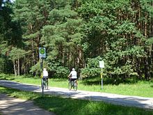
There is a 650 km long network of cycling and hiking trails in the park. In addition to this, there are numerous viewing platforms, moor walkways and screens for bird watching. Some of these facilities are barrier-free [3].
Information points and entrance gates


- 1 Müritzeum - House of 1000 Lakes in Were - With 2000 m² the largest experience and information center with exhibitions about the park. You can see, among other things. a large freshwater aquarium that introduces the underwater world in the land of 1000 lakes (www.mueritzeum.de)
- 4 National Park access Federow - The hamlet is 7 km south of Waren and is therefore the most important north entrance gate in the national park. There is an information point with tour offers for guided bike and hiking tours with rangers in the park as well as bike rental for individual bike tours. In the exhibition you can look "live" into an osprey nest with a webcam. Nearby is the 1 Hofsee observation station
 . To the south you get to the 2 Bird observation tower on the Rederangsee.
- 2 National Park Information Federow, Damerower Strasse 6, 17192 Federow. Tel.: 49 (0)3991 - 668849. Open: Easter to October, daily 9:00 a.m. to 6:00 p.m.
- 5 Schwarzenhof National Park access - National park information point with exhibition on sea eagles.
- 3 Schwarzenhof National Park Information, Schwarzenhof 15, 17192 Kargow. Tel.: 49 (0)3991 633410. Open: Easter, May - October daily 10 am-5pm.
- From the Schwarz stop of the National Park bus line, you can head south past the Specker See (4 Specker See observation tower) and along the Hermannsgraben, with which the Specker See and the Binnenmüritz were drained (5 Innermüritz observation tower), with a possible short detour to 6 Bird observation center Müritzblick hike back to Boek (approx. 3 hours).
- 6 National park access Boek - The small village near the Müritz is from the south her a Entrance gate to the park. There is a national park information center in the manor house, a tin figure workshop with a tin figure museum (info). There are of course parking spaces and there is a connection to the national park bus.
- 7 Boek Manor, National Park Information, Boeker Strasse 36, 17284 Boek. National park information center, shop.Open: Easter, May - October daily 10 am-5pm.
- The hike south to the osprey observation points at the is particularly worthwhile in the morning 8 Boeker fish ponds and, if necessary, continue to the 9 Fish ponds of Tender joke.
- 7 National park access Blankenförde - National park information with an exhibition on the renaturation of the Zootensee lowlands and on the water hiking routes.
- 10 National Park Information Blankenförde, Blankenförde 30, 17252 Roggentin. Tel.: 49 (0)39829 229190. Open: Easter, May to October daily 10 am-5pm.
- 8 Kratzeburg National Park access - Good entry point for the train journey to the park, as there is a train stop on the route Were - Neustrelitz gives. There is national park information with an exhibition about bats. The "Obere Havel" water hiking route also begins in Kratzeburg (see section Water hiking).
- 11 Kratzeburg National Park Information, Dorfstrasse 31, 17237 Kratzeburg. Tel.: 49 (0)39822 29665. Open: Easter, May to October daily 10 am-5pm.
- 12 National Park Information Neustrelitz, Strelitzer Str. 1, 17235 Neustrelitz. Tel.: 49 (0)3981 253106. Open: May - September Mon-Fri 9:00 am-6:00pm, Sat / Sun 9:30 am-1:00pm; October Mon-Thu 9:00 a.m.-12: 00 p.m. and 1:00 p.m.-4: 00 p.m., Fri 9:00 a.m.-12: 00 p.m.

- Serrahn - The smaller, separate part of the park is east of Neustrelitz. At 9 Zinow A 4 km long forest adventure trail begins, which leads over the development of the whale and to the primeval beech forests, which are part of the world natural heritage. Of a 13 Observation tower you can look out over the Serrahnsee, the path continues over you 14 Moorsteg. An exhibition on the world natural heritage of the Serrahn beech forests be visited. The eastern access to the Serrahn National Park can be found in 10 Carpin National Park access, from there you can also hike to Serrahn, the path is approx. 4 - 5 km from both sides
 .
.
- 15 Forester's lodge Serrahn, Forsthaus Serrahn, 17237 Zinow. Tel.: 49 (0)39821 41500. Open: April to October daily 10 a.m. to 5 p.m., November to March when the park rangers are present.
Tourist Attractions
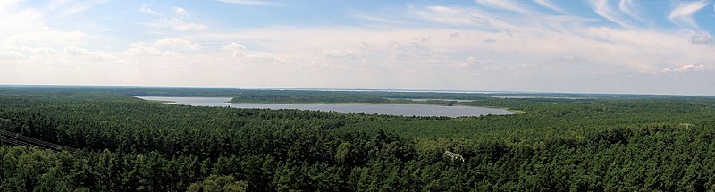

- 16 Käflingsberg Tower - The 55 m high mobile phone and fire watch tower is located in the heart of the park on the 100.2 m high Käflingsberg, southeast of the hamlet of Speck, and offers a wide panoramic view of the national park. At a height of 31 m, the 55 m high tower has a freely accessible viewing platform with a wide view of the forest and lake landscape of the national park. The ascent is via a steel staircase with 167 steps (No entry; Donation of 1 € is welcome
 ). There is no elevator. The building is a nice destination for a bike ride, the last 700 m from the national park bus stop is walking distance.
- At near 17 Priesterbäker lake is an observation platform set up.
- another 18 Observation tower with a view over the Zotzensee can be reached from Krienke on a footpath.
activities


- Bird watching ("Birdwatching"), sea eagles and ospreys can be seen in particular, and cranes at the time of the crane's arrival in October, as well as numerous other water birds.
- To go biking - There are good opportunities for cycling in the spacious park. Bicycle rentals can be found at many national park entrances. The bike can also be used as a means of transport to entry points for smaller hikes in the extensive park area. The national park area is also crossed by supra-regional long-distance bike trails. These include the Berlin-Copenhagen cycle route, the Havel cycle path, the Mecklenburg Lake Cycle Path and the cycle path around the Müritz.
- An attractive tour is e.g. B. the 21 km long circular tour "Around the Specker Lakes", signposted with a blue cyclist. On the circuit you pass various lakes, the Käflingsberg tower and of course the Müritz. Entry points to the circuit are Boek from the south and Federow or Schwarzenhof from the north. There are car parking spaces and bike rentals.
- hike - many destinations such as observation platforms can only be reached on foot. In order to cover the sometimes quite long distances in the extensive park on foot, you can use the National park bus use from the entrance gates. The 175 km long Müritz National Park hiking trail and the Mecklenburg Lake District pilgrimage route are ideal for longer hiking tours.
- Water hiking - From the Kratzeburg, the 23 km long scenic water hiking route "Obere Havel" leads through the heart of the park over several lakes to Userin. Motorboats are not allowed to use this route. Land bridges are crossed with lorries for boat transport. In some cases there are also transfer points at weirs. A second water hiking route in the national park is the "old trip", which leads from the Müritz over the Bolter lock to Mirow to the Müritz-Havel waterway (for more information and rules on paddling in the park, see "Water hiking" leaflet of the National Park with an overview map of the routes on page 2).
to buy
In the larger information points (Müritzeum, Federow, Boek, Neustrelitz) there are souvenir shops with some regional products. There are artisans based in some villages in the national park region.
kitchen
Inns and tourist restaurants are in the cities of Neustrelitz, Mirow, Waren and Wesenberg as well as in some villages in or around the Müritz National Park. Due to the greater distances, it is advisable to clarify opening times in advance, especially out of season.
accommodation
There is a wide range of different types of accommodation in the national park region: hotels, guest houses, holiday apartments and houses as well as youth hostels. The provides an overview of a large number of the quarters available in the national park region Mecklenburg Lake District Tourist Association[4] as well as the local tourist information in Waren, Neustrelitz, Wesenberg, Mirow, Rechlin, Röbel and Feldberg.
Hotels and hostels
The cooperation between Müritz National Park partner[5]whose 48 companies are committed to the Müritz National Park and thus contribute to the preservation of the protected area. The predominantly tourist businesses offer products and services, the quality of which is proven by certification marks. Great emphasis is placed on environmental orientation and the use of regional products. In order to offer guests and visitors a special service, the partner companies provide up-to-date and well-founded information about the Müritz National Park. Whether in a tent or in a historic manor house, the National Park partners have a wide range of accommodation options - what all quarters have in common is the attractive location and the commitment of the hosts to nature and their region.
The National Park Office also operates the Youth forest home Steinmühle[6], whose offer is primarily aimed at school classes and advanced training groups.
Bolter mill - Apartments and rooms History and information about the Bolter mill
camping
In the Müritz part of the national park and in the neighboring villages there are numerous campsites, most of which are located on lakes and thus offer swimming opportunities. There are no campsites around the Serrahn part of the national park. Wild camping is not permitted in the national park area.
security
The stay in the national park area is usually safe. The following instructions should be observed: Dying and dead trees are only removed in acute danger, which is why trees and parts of trees may fall over at any time. The state of Mecklenburg-Western Pomerania is not liable for these dangers posed by the forest in the national park. You enter at your own risk. Avoid staying in the national park during storms or thunderstorms.
For the national park area there is a high risk of forest fire due to the high proportion of forests of 72% with the main tree species pine. That's why there are five Forest fire hazard levels:
- 1 very low
- 2 low
- 3 medium
- 4 high
- 5 very high
The forest fire risk is assessed by the forest authorities according to the weather and vegetation development. Correspondingly, preventive measures are triggered from warning level 2. From level 4, forest areas can be closed locally. Regardless of the triggered forest fire warning level, the following safety requirements always apply, which must be observed:
- Don't smoke in the forest!
- Do not throw any leftover cigarettes out of the car window!
- Don't make a fire in the forest!
- Keep access roads to the forest free!
- Do not park cars on dry grass or stubble!
- Report all fires immediately to the fire brigade (emergency number 112) or the police (emergency number 110)
About 10% of the national park are former military training areasthat are contaminated with ammunition. These areas are marked with signs. Entering means danger to life!
trips
- Tiergarten Ivenacker Eichen (30 km northeast of goods) - A nice destination for nature and tree lovers who z. B. have moved into their quarters in Waren, is the near-natural zoo "Ivenacker Eichen" northeast of Stavenhagen. In the spacious area with 10 km of hiking trails, Germany's oldest oaks are 1000 to 1200 years old. Furthermore, there are of course various game gates in the park. More see here in the article Stavenhagen.
- Feldberger Seenlandschaft Nature Park (30 km east of Neustrelitz) - Sights are the numerous lakes in the terminal moraine landscape, the view from the Reiherberg, the forest museum "Lütt Holthus" in Lüttenhagen, the beech forest "Heilige Hallen" and the Fallada archive in Carwitz.
literature
- Cycling and hiking map of the Müritz National Park ISBN 3-932115-00-7
- Extensive series of cycling, hiking and water hiking maps for the Müritz National Park and the Mecklenburg Lake District region by Klemmer Verlag, which is based in Waren ISBN 978-3-940175-01-4
- ADFC regional map 1: 75000 "Mecklenburgische Seenplatte", tear and weatherproof cycling map with extensive special legend for cycling. ISBN 978-3-87073-564-7 , Bielefelder Verlag
