
The Harz National Park is lying in Lower Saxony and Saxony-Anhalt Part of the plateau of the Upper Harz. The park shows a complete cross-section of the flora and fauna of the Resin to the subalpine flora on the Chunks.
background

history
The Lower Saxony National Park was founded in the western part of Germany on January 1, 1994. The Hochharz National Park in Saxony-Anhalt was set up by the last GDR government on October 1, 1990 as part of its national park program.
On January 1, 2006, the Harz National Park in Lower Saxony and the Hochharz National Park in Saxony-Anhalt finally merged to form today's cross-border Harz National Park. The park is now also part of the European system of protected areas Natura 2000.
landscape
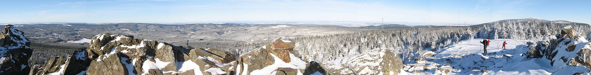
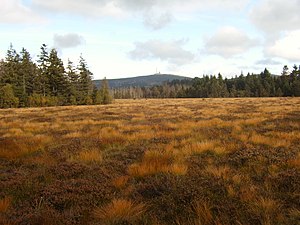
The landscape is characterized by a little touched nature. In the area around the Brocken there are natural primeval forests that change from spruce forest to mixed beech forests in the lower elevations. In the high areas around Torfhaus, raised bogs also characterize the landscape. The national park is located at altitudes between 250 m and 1142 m above sea level.
Flora and fauna

The national park includes all six vegetation zones found in the mountains:
- Kolline level: Harz edge between 250 and 300 m above sea level. NN
- Submontane stage: lower layers between 300 and 525 m above sea level. NN
- Montane level: medium altitude between 525 and 750 m above sea level. NN
- Upper Montane level: higher altitudes of the Upper and High Harz Mountains between 750 and 850 m above sea level. NN
- High montane level: highest locations in the high Harz between 850 and 1,000 m above sea level. NN (with the exception of the Brocken summit, which is even higher)
- Subalpine level: Brockenkuppe above 1,000 m above sea level NN
There are different types of biotopes in the park:
- Raised bogs - are mainly fed by precipitation.
- Fens - are mainly fed by groundwater.
- Natural spruce forests - actually only occur in the Harz Mountains above an altitude of 800 m. In the context of forestry, however, the beech forests of the lower elevations have often been replaced by spruce forests.
- Beech forests - occur in the Harz in the lower layers. In the area of 700 - 800 m height they merge into mixed forests (beech-spruce). The rare wildcat is at home in the beech forest.
The shy lynx has recently returned to the park. A has been running since 2000 Resettlement Project.
In addition, the wildcat, which also lives very secluded, occurs in the depths of the forests.
climate
The Harz is characterized by a harsh climate, which is most pronounced on the Brocken: high amounts of precipitation, low temperatures, often fog and, especially on the Brocken, often high wind speeds up to hurricane strength. Anyone who starts with the Brockenbahn in Wernigerode in sunshine and drives up the Brocken has to be prepared for everything: snowstorms and, above all, fog. Good visibility is not a matter of course in the Harz Mountains.
getting there
A nostalgic way to get there is to take the Harzquer- / Brockenbahn from Wernigerode or Nordhausen, see article for detailed information Chunks.
Suitable places for arrival and, if necessary, accommodation are in Lower Saxony: Bad Harzburg, Altenau, St. Andreasberg, Herzberg and Braunlage, in Saxony-Anhalt Ilsenburg and Wernigerode. Specific travel information can be found in the local articles.
Radler on the Weser-Harz-Heide-Radweg pass the national park area on the section from Herzberg to Riefensbeek-Kamschlacken.
mobility
The best way to explore the national park is on foot. In winter, cross-country skis are also a popular means of transport due to the attractive network of trails. In many places there are parking spaces for hikers, from which one can take day tours. The park can also be easily reached by environmentally friendly local public transport. The extensive network of hiking trails is well marked in the area of the national park. Still, using a hiking map makes sense, so that one can orientate oneself better.

In the national park there is Route requirement. Entering the forest or park away from designated paths / trails is to protect nature not allowed. Orders from rangers in the area must be followed in this regard. In the park live z. Sometimes very shy wild animals such as the lynx and the wild cat, which need appropriate retreats. Wild animals, which are often "frightened" in winter, use an unnecessarily large amount of energy to escape from humans in the deep snow. If this happens more often, such "overactive" escape behavior can lead to death, especially in severe winters. Even supposedly rare individual disorders disused, closed hiking routes therefore add up.
Notes on Openstreetmap: In the free wiki world map, some paths are shown in the park area that have been closed due to the nature conservation reasons mentioned above. For "normal users" of Openstreetmap, however, these routes may not be immediately recognizable as blocked routes on the map. The symbol for "blocked route" in Openstreetmap-Mapnik is an overlaid, broader red dashed line. This applies e.g. B. for the quiet zones on the much-visited Brocken (see also section there literature or sketch on the right). These routes are usually no longer included in regular hiking maps.
Tourist Attractions
Chunks
- At 1142 m, the highest mountain in the Harz Mountains, which is popularly visited.
Peat house
- Location:Peat house is centrally located on the B4 in the national park. The highest settlement in the Harz (located at 811 m above sea level) is the starting point for the popular hike to the Brocken over the Goetheweg. From here you also have a beautiful view of the highest mountain in the Harz Mountains.
- National Park House - Collection on the nature and fauna of the national park
Figure eight
- Lookout point: The 926 m high cliff is a beautiful vantage point about 5 km northeast of Braunlage at 1 lies. The approximately 15-20 m high, tree-free knoll rises steeply above the forest. There is a beautiful view over the forests of the Harz National Park. Furthermore are Chunks, Bruchberg and Wurmberg to see.
- Access: Car parking spaces on the B4 near Oderbrück 1 or king jug 2 ; from here hiking trails lead to the granite dome (approx. 2 km one way); Cyclists can ride on roads from Königskrug to just below the hilltop.

Wolfswarte on Bruchberg
The rock cliffs of the Wolfswarte are approx. 3 km west of Peat house2 . From a height of 918 m you have a beautiful view over large parts of the western and high Harz mountains, including the Chunks can be seen. With the exception of the Wolfswarte, the mountain is not accessible to hikers. When there is a lot of snow, the Wolfswarte is only accessible with cross-country skis, as the hiking trails are not cleared or used as a cross-country ski run. Right on the cliff there are no protection from the weather. If there is a risk of thunderstorms, you should avoid a hike to the fairly exposed Wolf Observatory.
Stamp number 135 ("Wolfswarte") of the "Harzer Wanderadel" is not found directly on the cliffs. The stamp box is located at the Butterstieg / Oberer Bruchbergweg branch about 250 m northwest below the rocks. A few meters further you will also find a neat, quite new one Refuge ("Altenauer Hut").
Access:
- Of Peat house From there you get to the cliff if you follow the path with the "Red Bar" (entry on the road to Altenau (approx. 3 km easy from Torfhaus with approx. 150 vertical meters, walking time: 40 - 60 min, partly bumpy, therefore on The hike from Torfhaus on the fairy tale trail between Torfhaus and Oderteich is also attractive see Oderteich with a visit to the wolf observatory.
- Of Altenau it is about 6 km up to the Wolfswarte via the path on Dammgraben and the Butterstieg. Depending on the start in Altenau, the ascent is about 400 to 450 meters in altitude. The steep butter ascent in the last part of the ascent is particularly attractive. Sturdy shoes are required for the bumpy, sometimes rocky mountain path.
- In winter, the fairly demanding, medium-difficulty route leads Altenau-Torfhaus trail pass below the Wolfswarte. The Wolfswarte itself, however, has to be climbed via deeply covered hiking trails, as the trail does not lead directly past the cliff. But there is guaranteed to be a real pioneering spirit when you fight your way uphill on a beautiful winter's day after a lot of fresh snow over the possibly untrodden snowdrifts on the hiking trails. You will be rewarded with a great panoramic view. However, if you're the first up there, there's a good chance that loneliness will soon be over. The vantage point is clearly visible from the trail, so that latecomers will of course be happy to use the freshly laid track. Alternatively, you can ski to the Wolfswarte from the goldfinch corner.
Oderteich


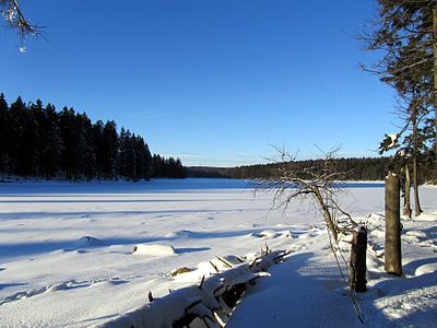

The reservoir, which is rather smaller for the Harz region 1 is at over 700 m altitude on the Harzhochstraße (B 242) in the area of the B 4. Das Swimming is allowed at your own risk (no lifeguards) in the southern area of the water, but the water is quite fresh. There is a parking lot for hikers in the area of the dam on the B 4. The Oderteich can also be reached by public buses that run on the B 4 or Harzhochstraße (B 242).
- History - The Oderteich is the largest reservoir in the Upper Harz water shelf and was once created to supply the water-powered conveying systems in the St. Andreasberg mines with conveying water. This historic facility still works today. However, the water is no longer used to drive the art of running, but is converted underground with the help of turbines and generators into electrical energy. If you want to follow the course of the water, you can follow the Rehberger Grabenweg in the direction of St. Andreasberg on foot or by bike. Here you can take a guided tour of the Samson mine huge water wheel with the ability to runcan be visited.
- Round trip around the Oderteich - A 4 km long hiking trail goes around the reservoir (walking time about 1.5 hours). For detailed directions with background information, see National park leaflet on the circular route.


- Hike on the fairy tale trail between Torfhaus and Oderteich - An attractive hiking route is the fairy tale trail to the settlement Peat house. The rustic route leads north of the Seerundweg slightly uphill through the wild forest landscape of the Hochharz. The path runs over small bridges and footbridges through partly boggy terrain. In Torfhaus you can visit the National Park House, stop for a break and enjoy the view of the Brocken when the visibility is good. If you feel like it, you can also take a short detour (just under 1 km) via the Goetheweg to the beautiful moor walkway on the Großer Torfmoor. At the Oderteich it is a good idea to visit a lake on the way there and back. This is how you get to know the entire circular route around the lake.

- The total length of the route there and back is about 12 km (including a detour to the Moorsteg in Torfhaus and completely around the Oderteich). Whoever feels like it can go back Wolf station with visit. Then about 16 km, which are a bit more mountainous). As footwear, waterproof, sturdy shoes are best, as the paths are sometimes bumpy and wet after rain.
Upper Oder Valley
The deeply cut upper Oder valley lies between Braunlage and St. Andreasberg. The valley can be explored on hiking trails (driving paths). Those are especially worth seeing 2 Hahnensee cliffs with a beautiful view of the wooded valley. The lookout point can be reached from Braunlage can be hiked from (about 3 km easy with about 200 meters of altitude).
Another beautiful hiking destination is the idyllic one in a forest clearing in the valley floor
Hanskühnenburg
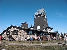

- 1 Hanskühnenburg. Tel.: (0)170 8 64 03 48, Email: [email protected]. The forest restaurant ("Baude") Hanskühnenburg is located on the summit Hanskühnenburg on the ridge "Auf dem Acker" in the western part of the national park. The mountain chalet is 811 m above sea level. NN is the highest of all Harzbauden and offers from its observation tower, which is accessible during the opening hours of the excursion restaurant, a wide view of the surrounding mountain towns and the peaks of the West and Hochharz, such as the Brocken and the Großer Knollen. 300 m northeast of the restaurant on the so-called Reitstieg you will also find the "Hanskühnenburg Cliff", which is well worth seeing. The Hanskühnenburg is only accessible on foot or by bike. In the mountain restaurant you can get some small hot and cold dishes, drinks and coffee and cake. Sunny terrace places outside and the fireplace in the interior make the hut a good resting place in any weather.Open: Daily 9 am-5pm, Nov-March until 4pm. Closed on Thursdays (except on public holidays).
From the Stieglitzecke car park (B242)
From 3 Goldfinch car park on the B242 between Clausthal-Zellerfeld and Sonnenberg, the best-known and also the least steep path leads to the Hanskühnenburg. The route is easy to manage as the parking lot is already at an altitude of around 800 m. There is also a bus stop here. Overall there are 7 km one way to the Bergbaude, back a little over 14 km. If there is a risk of thunderstorms, you should do the hike Not to tackle, as partially forest-free area is crossed.
From the goldfinch corner there are two paths that lead to the Hanskühnenburg:
- The Riding climb along the north-western side of the ridge it is swampy and bumpy in larger sections, after longer rainfall many sections of the path can be really difficult, especially due to the very muddy ground. It should only be approached with ankle-high hiking boots. This path is not suitable for prams and people with reduced mobility. Due to the cliffs and the views towards Clausthal-Zellerfeld on the way, this is the nicer section, but you should plan a much longer time for the way than on the Ackerstraße.
- The Ackerstrasse runs south-east of the ridge and is almost continuously a wide, finely graveled forest road, which is very easy to walk and almost incline-free. Only the last 500 m lead very stiffly in a few twists up to the Hanskühnenburg. At the beginning the European long-distance hiking trail E6 on this route, but leaves Akerstraße about halfway and leads down into the valley Sieber. The path on the forest road leads continuously through spruce forest and is therefore more monotonous compared to the riding path, but much easier to master.
- If you want, you can of course do a circular hike, which is a little over 14 km in total.
- In winter, the mountain chalet can also be reached over the 16 km long with good snow conditions Farm trailwhich also starts at the Stieglitzecke parking lot.
From Lonau
From Lonau, a district of Herzberg am Harz, two approximately 7.5 km long, relatively easy to walk hiking routes lead to the Hanskühnenburg.
4 Parking lot at Kirchtal Lonau By the Church valley: Asphalted forest road with a constant gradient. Groomed cross-country ski run in winter.
5 Mariental Lonau car park By the Mariental: Relatively comfortable ascent to Hanskühnenburg on a wide forest road. In winter the route is partly a toboggan run.
From Sieber
Out Sieber On the way up to the Hanskühnenburg you have to climb a little more than 5 km, 600 meters in altitude on the direct route. However, there are numerous ways of ascending from the Siebertal to the ridge. It's a bit detoured about the European long-distance footpath E6, from which you turn left on the Ackerstraße and follow the forest path to the last ascent to the Hanskühnenburg (approx. 8 km one way, 700 m ascent).
More ways to the Hanskühnenburg
- Of Riefensbeek-Kamschlacken there is an approx. 5.5 km long path from the parking lot on the B498 and a very steep, approx. 3.5 km long path directly from the center of the village to the Hanskühnenburg (the shortest way up).
- From the Sösetalsperre you can reach the hill from the parking lot at the Vorsperre in about 5.5 km, at first relatively laughing Riefensbeeker shaft, along a torrent, later steeper upwards. From Sösestaudamm (parking lot) it is about 8 km on the Harzer Baudensteig.
- Of Osterode the longest path (11 km) leads to the Hanskühnenburg, past the Rope cliffs and later also on the Harzer Baudensteig
Raven cliff with a lynx enclosure
The 3 Raven cliff is about 550 m above the Eckertal and is an attractive hiking destination Bad Harzburg. There is a restaurant on the cliff. The granite rock of the Rabenklippe is partly accessible. From the cliff you have a view over the Ecklertal, which on clear days up to Chunks enough.
In the area of the Rabenklippe lies a Lynx enclosure of the Harz National Park. Here the shy animals can, among other things. can be viewed from a covered observation pulpit.
Access: From Bad Harzburg-The city center is about 5 km easy walk with about 300 meters of altitude. Those who use the cable car on Burgberg uphill can comfortably cover 186 meters in altitude in the historic cable car from 1929:
- Burgbergbahn
- For those arriving by car, there is a parking lot right at the valley station of the train. There is also a national park bus line that goes directly to the Rabenklippe.
Ilsetal

The lively Ilse mountain stream flows through the romantic forest valley. In the middle of the Ilse Valley, the torrent plunges down into the cascading Ilse Falls. You can access the valley from Ilsenburg on hiking trails. For pedestrians, there is a natural hiking trail, mostly right on the torrent. Part of this path is anchored in the slope with bridges. There is also a gravel road as a route for cyclists. The Ilsenburger Chaussee, laid out between 1830 and 1838, leads over the Gelben Brink to the Brocken bed on the Brockenstrasse, the Chaussee is closed to motor vehicle traffic. At the top of the Brocken bed at a height of 900 m, the approx. 300 m long primeval forest ascent opens up the primeval forest and the source area of the Ilse. A popular hiking route also leads through the Ilsetal to Chunks.
Wilder Harz: rocky cliffs in the Renneckenberg and Hohnekamm area

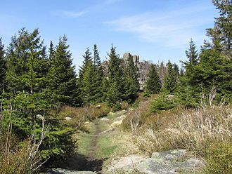
In its eastern slope, the "Brocken Mountains" show their particularly wild side. There are numerous rocky cliffs in the ridge of the Renneckenberg and Hohnekamm. Some of the cliffs are located in the sensitive core zone of the national park and can therefore not be climbed, but the most attractive rocks are accessible via paths. Well-known hiking destinations here are, for example, the Obere Zeterklippe, the Leistenklippe and the imposing Ottofelsen.
In the Renneckenberg area


- 3 Upper Zeterklippen (930 m), also known as the "Great Zeterklippe", is the most famous viewpoint in the Renneckenberg area. Those who have climbed the stairs on the rock formation will have an almost unobstructed panoramic view of the wilderness of the Hochharzes. To the west the view goes over to the near one Chunks. In the northwest the Scharfenstein can be seen, in the north the Harz foreland and others. with Wernigerode. To the southeast you can see over to the Hohnekamm with the Grenz and Leistenklippe. At the entrance to the rock there is also the stamp point no. 10 "upper Zeterklippe" of the "Harzer Wanderadel".
- Access: The cliff is only accessible via hiking trails that are also designated as MTB routes. From the road on the Gelben Brink it is 1.2 km easy (connect touring bikes to the gravel road). The stony mountain hiking trails are not suitable for pushchairs. There is also a short wooden walkway in a swampy area.
- Lower Zeterklippen (approx. 830 m)1 - These cliffs lie in front of the Zeterklippenweg north of the Upper Zeterklippe. Location of a refuge. Also noteworthy view over to the Brocken.
- Sun cliffs 749 m2 - Wonderful west view of the Brocken and the upper and lower Zeterklippe. The rocks are largely off the beaten track. According to internet sources, climbing the cliff should not be entirely harmless
- Access: According to the Openstreetmap, a 400 m long hiking trail leads from the east-facing road as a branch path to the rocky cliffs.
- Brockenkinder3 - to be found near the Brockenstrasse on the Brocken bed. This nice, smaller rock formation is ingrown in the high forest. So there is no prospect.
- Chapel cliff4 - According to the national park's route plan, the rocks near the Glashüttenweg are accessible via an unmarked hiking trail.
Scorn


- Leistenklippe (901 m)5 - Attractive, very much visited summit point for hikers in the Hohnekamm. The cliff equipped with stairs is relatively well known. From up here you have an attractive panoramic view of the wilderness of the Hochharz. You can see, among others. Wernigerode, the Wurmberg and of course the Chunks. At the approach to the cliff there is stamp number 15 of the "Harzer Wanderadel").
- Access: Access is only possible via hiking trails that are not suitable for pushchairs.
- Boundary Cliff and Bear Cliff - Both cliffs are not accessible because they are in the core zone of the national park. The "Hohnekamm-Gratweg" in the direction of the Landmannklippe leads past quite close.
- Hell cliff - The rock lies in the core zone of the national park and cannot be hiked.
- Trudenstein6 - Located directly on the popular Glashüttenweg. The rock is easy to climb using a steel staircase. Nice view over the vast forests of the Eastern Harz and over to the Wurmberg.
- Peasant Cliff7 - Rock cliff off the beaten track at the northern end of the Hohekamm. The rock has no stairs and is probably only safe to conquer for more experienced climbers. A summit book awaits you at the top. Nice view, among other things. to the Renneckenberg and the Brocken. Access is probably possible via the Hölle-Lehmann path from Schierke. Alternatively, the cliff can also be reached via the "Hohnekamm-Gratweg" from the Leistenklippe. From the northwest from the Weringerode area, the stairway leads relatively close to the rock.
- Access: The small branch path to the Landmannklippe branches off 8 from the stairs down (on the sign with a dead end sign "Landmannklippe"). There are probably red arrows indicating the way to the rock. The branch path is included in the national park plan and can be used with it.
Otto rocks

The much-visited Ottofelsen already stands by outside the borders of the national park to the east 9 . Due to its prominent position under the rocky cliffs of the Harz Mountains, it should nevertheless be briefly presented here. On a hike z. B. from Wernigerode into the rocky world of the national park you can still visit the Ottofelsen. The 36 m high rock has been provided with secured steel stairs since 1896. In 1990 the staircase was renewed. The striking rock cliff with its characteristic wool sack weathering is visited a lot. The rock also attracts climbers in particular.
further goals
- Geopark Harz - Braunschweiger Land - Ostfalen.


 in der Datenbank Wikidata") The Geopark includes nature parks and other nature conservation areas in the Harz, in the Braunschweiger Land and Ostfalen with Elm and Drömling in an area of about 100 × 120 kilometers.
The Geopark includes nature parks and other nature conservation areas in the Harz, in the Braunschweiger Land and Ostfalen with Elm and Drömling in an area of about 100 × 120 kilometers.
activities
- hike - e.g. B. on the Brocken. Most of the ascent to the Brocken takes place in the national park (see article for detailed information Chunks). See also the sections above for hiking suggestions for sights.
- Cycling and mountain biking - is only allowed on the paved paths. Sometimes there are hiking trails, such as B. the New Goetheweg on the Brocken Railway is closed to bicycles. Please show consideration for hikers. It is best to ring the doorbell early.
- Cross-country skiing in winter - please refer Topic article "Winter sports in the Harz"
- Bathing in Oderteich
kitchen
There are several inns and excursion restaurants that are located directly in the park area and are good destinations for excursion activities. These include:
- On the Chunks:
- Brockenwirt, Brocken Plateau, 38879 Schierke. Tel.: 49 3 94 55 120, Fax: 49 3 94 55 12 100, Email: [email protected].
- Forest restaurant Rinderstall, Rinderstall 1, 37444 St. Andreasberg (in the valley floor of the Oder valley). Tel.: 49 55 82 740, Fax: 49 55 82 80 99 19, Email: [email protected]. Open: on public holidays; Nov.-Apr. 10:30 a.m. - 5:00 p.m., summer time 10:30 a.m. - 5:30 p.m., closed on Wednesdays.
For restaurants within closed locations, see the relevant local article.
accommodation

The guest beds are centrally located in the park Peat house. However, there is hardly any further infrastructure here, (kiosk; globetrotter store available), for example shopping opportunities.
Places in or on the edge of the national park:
security
See also the article Hiking safety
Entering the jungle areas in the park at Avoid a storm, since then there is a mortal danger from felling. In general, the high proportion of dead wood in natural forests means that the risk of branch breakage is always higher than in commercial forests. It is also important to note that no campfires may be lit in the national park!

Attention: Simple, wooden shelters Without an iron air-termination rod on the roof, lightning rods and ring anchors in the foundation, they do not provide adequate protection against storms. On the contrary: Exposed huts can develop into a deadly trap during a thunderstorm. Unfortunately, tragic accidents in this regard have already occurred in other regions.[1][2][3]
During a Brockentour in March 2012, there were unfortunately even exposed shelters in the park area missing lightning protection systems detected.
As of February 5, 2013, the topic "Shelters and lightning protection" is unfortunately on the Harz National Park website not discussed. In addition to the hut on the triangular pile, the "Altenauer hut", which is in a much more exposed area, also has 10 There is no lightning protection below the Wolfswarte. The hut seems to be an almost identical, newer model of the hut on the triangular pole. Also at the small Spitzgiebelhütte in the bone breaker curve of Brockenstrasse 11 no lightning rods could be seen in March 2012. The same was true for the small pointed gable hut "Eiserner Tisch" 12 on the high and exposed Hirtenstieg north of the small Brocken. With regard to the lack of lightning protection systems at shelters, the Harz National Park is no exception in Germany. Lightning protection systems are missing on almost all wooden shelters in low mountain ranges, but also on cycle routes in valleys.
Alpine Bivouac boxes are usually made of metal from the start (Faraday cage protection principle).
Getting along: nature park centers and ranger stations
The numerous nature park centers and ranger stations in the national park area provide information and rest stops. Some of them can be reached by car - such as the houses in Torfhaus and Sankt Andreasberg, others you have to hike or you can take the Brockenbahn to get there, such as the Brockenhaus:
- 1 Ranger station Scharfenstein. Tel.: 49 160 71 48 827. Also a rest area with the sale of refreshments.Open: Open daily from 10 a.m. to 4 p.m.Price: free entry.
- 2 National Park House Ilsetal, Ilsetal 5, 38871 Ilsenburg, Germany. Tel.: 49 39 452 89 494. Open: Tue-Sun 8.30 a.m.-4.30 p.m., closed on Mondays (except on public holidays).Price: free entry.
- 3 Second hand. Open: Open daily from 9:30 a.m. to 5:00 p.m., 365 days a year.Price: adult € 4, child. € 2.
- 4 Torfhaus National Park Visitor Center, Torfhaus 38 B, 38667 Torfhaus. Tel.: 49 53 20 33 17 90, Fax: 49 53 20 33 17 919, Email: [email protected]. Open: April-Oct. daily 9 a.m. - 5 p.m. Nov-March Tue-Sun 10 a.m. - 4 p.m., also open on Mondays during school holidays and public holidays.
- 5 HohneHof nature experience center, Drei Annen Hohne 100, 38879 Schierke. Tel.: 49 39 455 86 40. 15 minutes walk from the Drei Annen Hohne car park.Open: Open daily from 10 a.m. to 4.30 p.m.Price: free entry.
- 6 Sankt Andreasberg National Park House, Erzwäsch 1, 37444 Sankt Andreasberg. Tel.: 49 (0) 5582 9230 74. Open: April - October Mon-Fri 10 am-6pm, Sat, Sun, public holidays 10 am-5pm. March Tue-Sun 10 am-5pm.Price: Free entry.
- 7 Schierke National Park House, Brockenstraße, 38879 Schierke. Tel.: 49 39 45 54 77. Geöffnet: Geöffnet täglich von 8.30 bis 16.30 Uhr.Price: free entry.
- 8 Haus der Natur, Nordhäuser Str. 1c, 38667 Bad Harzburg. Tel.: 49 53 22 78 43 37, Email: [email protected]. Geöffnet: Di-So 10-17 Uhr, Mo Ruhetag (außer Feiertage).Preis: Erw. 3 €, Ki. 1 €.
literature

Hiking maps
Folgende Karten decken zusammen den Nationalpark komplett ab:
- Karten-Set "Harz 1:50.000" der Verwaltungen für Landesvermessung von Niedersachsen und Sachsen-Anhalt. Zwei topografische Freizeitkarten und ein Beiheft stellen das gesamte Gebirge großräumig da. Das Kartenset ist das offizielle Kartenwerk des Harzklubs; ISBN 978-3-89761-111-5 (Auflage 2009); € 12.90
- Kompass Wander- und Bikekarte Westharz 1:50.000 - mit Brocken; ISBN 978-3-85491-134-0 6,95 €; Anhand der Karte lassen sich gut die "kleinen" Wanderwege finden, da die Routensignatur parallel zu den Fahrwegen eingezeichnet wurde. Ist in der Karte nur eine Rote Linie eingezeichnet, so handelt es sich meist um einen Wanderpfad. - Kompass Verlag
- Kompass Wander- und Bikekarte Ostharz 1:50.000 mit Brocken; ISBN 978-3-85491-632-1 ; Kartenbild wie oben - Kompass Verlag
- Wintersportarten please refer Themenartikel "Wintersport im Harz".
Web links
- Offizielle Seite des Nationalpark Harz
- Gesellschaft zur Förderung des Nationalparks Harz e. V. - Seiten des Fördervereins
Individual evidence
- ↑HNA of June 26, 2012: "Waldeck tragedy: the shock is still deep" - accessed on February 7, 2013
- ↑HNA of July 1, 2012: "Lack of lightning protection on golf courses:" Problem has been known for a long time " - accessed on February 7, 2013
- ↑HNA of July 1, 2012: "Mourning and sympathy after the thunderstorm accident in Waldeck" - accessed on February 7, 2013
