The Oristano Province is to the west of Sardinia and occupies about a sixth of the area of the island.
Regions
.jpg/300px-Campidano_di_Oristano_(01).jpg)
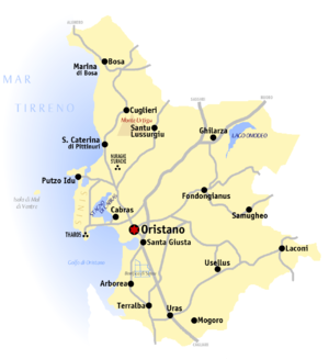
The province was established in 1974 within its current boundaries and covers approx. 3000 km², it includes the following (sub) regions
- Planargia: the region stretches from the Temo river to the Montiferru massif in the south; the town is the capital Bosa.
- Montiferru: the volcanic massif of Montiferru consists mainly of basalt rock, the highest point is the Monte Urtigu (1050 m above sea level); the main town is Cuglieri.
- in the west the Sinis Peninsula into the Tyrrhenian Sea, at the southern tip are the ruins of the Phoenician foundation Tharros.
- Campidano di Oristano: part of the province belongs to the plain of Campidano, which is located in the southwest of Sardinia from Oristano extends down to Cagliari.
- Marghine: the region extends from the Abbasanta high plateau to the mountain range in the east that borders the Nuoro Province forms, the main place is Macomer (already belongs to Nuoro Province).
- Barigadu: in the interior of the island, the land, which is largely overgrown with macchia, extends.
- Marmilla: the region stretches between Campidano and the central mountain range, in the south the Mannu river forms the border.
places
&groups=Maske,Track,Aktivitaet,Anderes,Anreise,Ausgehen,Aussicht,Besiedelt,Fehler,Gebiet,Kaufen,Kueche,Sehenswert,Unterkunft,aquamarinblau,cosmos,gold,hellgruen,orange,pflaumenblau,rot,silber,violett)

- 1 Oristano


 in the Wikidata database") , the provincial capital
, the provincial capital - 2 Bosa, picturesque town at the mouth of the Temo river
- 3 Cuglieri
- 4 Convertibles, Fishing village on the Stagno di Cabras, the municipality also includes the Sinis Peninsula and the grounds of 5 Tharros
- 6 Abbasanta
- 7 Arborea
- 8 Terralba


.JPG/350px-Cabras_-_Panorama_(01).JPG)

.JPG/350px-Abbasanta,_panorama_(01).JPG)
.JPG/350px-Arborea_-_Municipio_(01).JPG)
.jpg/350px-Terralba_-_Piazza_Cattedrale_(01).jpg)
Other goals
background
The Oristano Province was only founded in 1974 as an independent province, previously the areas had become the provinces Nuoro and Cagliari belongs. In the 11th century, the Sardinian rulers succeeded the Byzantine rule Judicates founded, one of which was the Arborea judiciary around the capital Oristanowhich was able to maintain its independence until 1478.
language
In Sardinia, Italian is the official language, locally the Sardinian dialect is mostly spoken in the province.
getting there
To arrival from mainland Italy to get to the island you have to use either the air route or a ferry connection. The main ferry ports are on the north and east coast of Sardinia, from the commercial port of Oristano there are no passenger ferry connections
- 1 Olbia located in the northeast of the island
- Genoa, Ferry connections through Moby Lines (12x / week) and Tirrenia (5x / week), approx. 10 hours
- Livorno (Height of Pisa), ferry connections through Moby Lines (14x / week) and Grimaldi Lines (14x / week), approx. 7 - 8 hours
- Piombino (between Livorno and Rome), ferry connections through Moby Lines (7x / week), approx. 5 - 6 hours
- Civitavecchia at Rome, Ferry connections through Moby Lines and Tirrenia
- 2 Porto Torres located in the northwest of the island
- Genoa, Ferry connections through Grandi Navi Veloci (5x / week) and Tirrenia (9x / week), approx. 12 hours
- Civitavecchia at Rome, Ferry connections through Grimaldi Lines (5x / week), approx. 7½ hours
- Barcelona (E), ferry connections through Grimaldi Lines (5x / week), approx. 12 hours
- Porto Vecchio and Ajaccio on Corsica, Ferry connections through Sardinia Ferries (once a week), approx. 3½ hours
- Toulon in South France, Ferry connections through Sardinia Ferries (3x / week), approx. 7 hours
- Marseille in South France, one ferry connection each through Corsica Linea and La Méridionale per week
- 3 Cagliari, the island's capital is located in the south of the island
mobility
The most important rail connections are those of the state railroad company Ferrovie dello Stato / Trenitalia operated main axes of Porto Aranci resp. Olbia in the east over Macomer, Oristano to the island capital Cagliari on the south coast. Of Macomer runs a narrow-gauge sideline of the Trenino Verde to Bosawhich is largely only of a tourist nature.
The most important Expressways roughly follow the course of the railway lines: The most important north-south connection in western Sardinia, the ![]() is partly expanded to four lanes and runs from Porto Torres above Sassari (which is bypassed) over Macomer and Oristano further in a south-easterly direction to Cagliari. The branch line of the SS 131CDN connects as an expressway Abbasanta With Nuoro.
is partly expanded to four lanes and runs from Porto Torres above Sassari (which is bypassed) over Macomer and Oristano further in a south-easterly direction to Cagliari. The branch line of the SS 131CDN connects as an expressway Abbasanta With Nuoro.
The winding road leads to the coastal road ![]() /
/![]() of Alghero to Bosa, the
of Alghero to Bosa, the ![]() leads over Cuglieri in the hinterland and then relatively close to the coast Oristano.
leads over Cuglieri in the hinterland and then relatively close to the coast Oristano.
Tourist Attractions
- the picturesque town Bosa at the mouth of the Temo
- the Sinis Peninsula with the dream beaches (u.s. "Is Arutas"), witnesses from the Nuragic culture and the Phoenician foundation Tharros
activities
kitchen
nightlife
security
climate
In the province of Oristano, as in the rest of Sardinia, there is a Mediterranean climate, rainfalls are rare in the summer months.