| Tour profile | |||
| height | km | Hm | |
| Andermatt | 0 | 0 | |
| Glacier | 31 | ||
| Brig-Glis | 80 | ||
| Sion | 141 | ||
| Martigny | 168 | ||
| Montreux | 215 | ||
| Lausanne | 241 | ||
| Nyon | 284 | ||
| Geneva | 309 | ||
| Overview | |||
 | |||
The Rhone route (Route du Rhône) runs from Andermatt (Oberwald) over the Furka Pass down the whole of Valais Montreux and then along Lake Geneva Geneva.
Route profile
- Length: 309 km
- Signposting: The route is as Rhone route no.1 signposted.
- Slopes:
- Andermatt - Genève: 1650 m
- Genève - Andermatt: 2710 m
- Incline with Veloverlad in train, bus ship
- Andermatt - Genève: 420 m
- Genève - Andermatt: 730 m
- Path condition: 26 km unpaved
- Traffic load:
- Suitable bike:
- Requirement: easy (without Furka pass)
- Fitness: Young people, adults, Oberwald – Montreux and families
- Inline suitability
- Good to know: Ernen - Brig-Glis, Leuk - Sierre, Evionnaz - St. Maurice, Villeneuve - Montreux, Villeneuve - St-Prex: main roads. Alternatives: rail or ship loading. When the weather is nice, a strong wind blows up the valley in the afternoon in Valais.
background
preparation
getting there
Public transportation
Many places on the routes from Cycling in Switzerland can be reached by train or bus. (please refer Bicycle transport in Switzerland)
By bicycle
Around seven of the eight other National Routes are connected to the Rhone Route:
- In Andermatt - Hospental the Rhine route and the North-South route.
- Via Gletsch you can reach the Rhone Route over the Grimsel Pass from the Aare route.
- On the Alpine panorama route can be reached in Illarsaz the Rhone route.
- The Lakes route reached in Montreux - Vevey the Lake Geneva, here you can either cycle along the lake to Geneva or cycle the Rhone route up the Valais.
- In Lausanne - St-Sulpice reaches the Mittelland route Lake Geneva and thus also the Rhone route
- Finally comes also Jura route in Nyon on the Rhone route.
Route description with sights
Andermatt - Oberwald: 38 km
- Of which unsurfaced: 0 km
- Places:Andermatt, Hospental, Realp, Furka Pass, Glacier, St. Niklaus, Oberwald
- Altitude difference
- Andermatt - Oberwald: 1000 m
- Oberwald - Andermatt: 1060 m
- Altitude meters with Veloverlad in train, bus ship
- Andermatt – Oberwald: 0 m
- Oberwald - Andermatt: 0 m
- Requirement: high
- For: Adults
- Good to know: Pass open from around May to October. Information Tel. 163 or [1].
Oberwald - Brig-Glis: 43 km
- Of which unsurfaced: 19 km
- Places:Oberwald, Niederwald, Appoint, Lax train station, Mörel, Brig-Glis/Naters
- Altitude difference
- Oberwald - Brig-Glis: 220 m
- Brig-Glis - Oberwald: 920 m
- Altitude meters with Veloverlad in train, bus ship
- Oberwald - Brig-Glis: 90 m
- Brig-Glis - Oberwald: 200 m
- Requirement: medium
- For: Families, young people, adults
- Good to know: Ernen - Brig-Glis on canton road with a lot of traffic. Alternatives: rail loading or mountain bike route Out of sight – Grengiols, about 2 km of bike, very scenic.
Brig-Glis - Sion: 60 km
- Of which unsurfaced: 2 km
- Altitude difference
- Brig-Glis - Sion: 70 m
- Sion - Brig-Glis: 260 m
- Altitude meters with Veloverlad in train, bus ship
- Brig-Glis - Sion: 30 m
- Sion - Brig-Glis: 120 m
- Requirement: light
- For: Families, young people, adults
- Good to know: When the weather is nice, a strong wind blows up the valley in the afternoon. Leuk – Sierre busy main road. Alternatives: rail loading or regional route Varen – Salgesch.
Sion - Montreux: 75 km
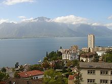
View over Lake Geneva to the Alps
- Of which unsurfaced: 3 km
- Altitude difference
- Sion - Montreux: 30 m
- Montreux - Sion: 140 m
- Altitude meters with Veloverlad in train, bus ship
- Sion - Montreux: 30 m
- Montreux - Sion: 140 m
- Requirement: light
- For: Families, young people, adults
- Good to know: When the weather is nice, a strong wind blows up the valley in the afternoon. Evionnaz – St. Maurice and Villeneuve - Montreux on main roads.
Montreux - Genève: 93 km

The route ends in Geneva, but the journey doesn't have to be over ...
- Montreux - Genève: 330 m
- Genève - Montreux: 330 m
- Altitude meters with Veloverlad in train, bus ship
- Montreux - Genève: 270 m
- Genève - Montreux: 270 m
- Requirement: medium, traffic experience
- For: Teenagers, adults
- Good to know: Villeneuve - St-Prex Main street with a lot of traffic. Alternatives: rail or ship loading.
Other places to stay
security
trips
Only the national and international routes are listed here. Regional routes still run in many regions and places.
- Andermatt - Hospental
- Glacier
- Montreux - Vevey
- Lausanne - St-Sulpice
- Nyon
References to literature and maps
Brochure:
- Cycling in Switzerland part 1 Rhone route: Werd-Verlag - Official route guide - ISBN 3-85932-395-4
Cards:
Hallwag / Kümmerly Frey publishing house
- Bike card 14 1:60000 Lausanne - Vallée de Joux, ISBN 3-259-00521-8
- Bike ticket 15 1:60000 Gruyère - Montreux - Gstaad, ISBN 3-259-00527-7
- Bike ticket 17 1:60000 Geneva, ISBN 3-259-00546-3