The Sella group, (Ital. il Sella, Ladin l Sela) lies in the central part of the Western Dolomites in Italy and is distributed over the three provinces South-Tirol, Trentino and Veneto. In addition to hikers and beginners in summer, the mountain range is the destination of alpine skiers, especially in winter: The Sella Ronda is the legendary circumnavigation of the Sella in a dreamlike rocky panorama of the Dolomites and above four alpine passes away.
Regions
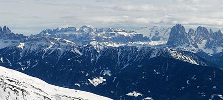
Essentially, the Sella Group is a prominent and widely visible table mountain with two distinct steps, the plateau of which is formed by some deep valley cuts (Midday valley, Lastiestal, Setus- and Pisciadùtal) can be divided into further mountain formations.
The highest peak on the plateau and relatively centrally located is the Piz Boè (3,151 m), the Cima Pisciadù (2,985 m) lies in the north of the plateau above the Passo Gardena. The Meisules are the plateau and the mountain pinnacles on the west side of the plateau, popular with climbers Val Gardena down. On the summit in the southwest Sass Pordoi (2,950 m) is a cable car.
The Sasso Capello mountain ridge (2,259 m), which is connected to Table Mountain by the Pordoi Pass (2,240 m), also belongs to the Sella group.
places
The mountain range itself is not populated, there are only a few Mountain huts and the accommodations (hotels) on the surrounding Alpine passes. The next localities in the surrounding mountain valleys are Selva in the Val Gardena, Colfosco and Corvara in the Val Badia and Arabba in Buchenstein.
background
The Sella Group, also known as Sella Group or simply Sella, is located in the central part of the western Dolomites, the dimensions of the mountain part with an irregularly round floor plan are approx. Six to seven kilometers.
The immediately neighboring mountain groups are the Marmolada in the south, the Sassolungo in the southwest and the Puez-Geisler in the North.
The surrounding valleys are that in the west Val Gardena, in the north that Val Badia in the south East Arabba / Buchenstein and in the southwest that Fassa Valley.
language
Most of the population in the surrounding valleys belongs to the Ladin language group (Rhaeto-Romanic), so Ladin is the colloquial language. German and Italian are spoken and understood.
getting there
The easiest way to get here is via the Innsbruck-Brenner-Klausen im Brenner motorway Eisack Valley with the motorway exit at Klausen / Gröden and further through the Val Gardena. The Sella Group is then at the eastern end of the valley.
In the high season and in winter or when the pass is blocked, depending on the destination, the journey can be made through the Val Badia be faster. From the motorway exit Brunico on the ![]() / E66 by the Val Pusteria to St. Lorenzen / San Lorenzo di Sebato / San Laurënz, then on the
/ E66 by the Val Pusteria to St. Lorenzen / San Lorenzo di Sebato / San Laurënz, then on the ![]() Direction Abtei / Badia, Corvara and Arabba / Rèba.
Direction Abtei / Badia, Corvara and Arabba / Rèba.
The next train stations are in Eisack Valley, continue with the bus.
mobility
The four alpine passes around the Sella are:
- The Gardena Pass (2,121 m) in the north and as an access from the Val Gardena in the Val Badia.
- In the southwest that Sella Pass and the Pordoi Pass (2.239 m) as access to Buchenstein and Arabba.
- In the east of the Passo Campolongo (1,875 m) as a connection from the Gadertal to Buchenstein and Arabba.
Tourist Attractions
Mountain peaks
Piz Boé
The 3.152 m (46 ° 30 '32 "N.11 ° 49 ′ 41 ″ E) The highest peak in the Sella massif is variously considered to be the "easiest" three-thousand-meter peak in the Dolomites and can be reached in summer from the Pordoi Pass by experienced hikers. For the last part of the Vallon via ferrata Surefootedness and a head for heights are required Via ferrata Cesare Piazzetta also leads to the summit and is considered difficult.
The summit also marks the tri-border region of the Dolomite provinces South-Tirol, Trentino and Veneto.
Sass Pordoi
The 2,950 m high rock summit (46 ° 30 ′ 6 ″ N.11 ° 48 '32 "E.) in the southwest corner of the massif can also be reached by non-mountaineers via a cable car, at the summit there is a restaurant with a panoramic terrace.
Midday valley
The term noon valley for the incision located on the plateau comes from the winter season: because of the orientation, the valley is only completely illuminated by the sun's rays at lunchtime.
The high point of the Mittagstal (Ladin Val de Mesdì, Italian: Val Mezdì) on the summit plateau can be reached from the mountain station on Sass Pordoi (2,950 m) via the Shelter at the Pordoischarte and the Boè hut (2,873 m) can be reached on foot in about three quarters of an hour. This is where a high-alpine ski run begins (only for experienced and skilled skiers), which goes north over a length of around four kilometers and sometimes very steeply down to an altitude of around 1,600 m Colfosco leads.
Lakes

- 1 Lake Pisciadù. The lake is located in the north of the Sella massif, see approach Pisciadù via ferrata.
- Dragon Lake. The Drachenseee (2,680 m ladin: Lech dl Dragon, Italian: Lago del Dragone) is a glacier lake that only exists temporarily on the Meisules plateau: the meltwater from the old snow fields and glacier remains is decisive for the water level.
activities
For general information on how to behave in the mountains, equipment, etc., see the article Rockclimbing.
In summer
Pisciadù via ferrata
The Pisciadù via ferrata (Via ferrata Brigata Tridentina al Pisciadu) is one of the most popular via ferratas in the Dolomites and the entire Alps and is very popular during the season, especially on weekends, its characteristic is the suspension bridge shortly before the end of the tour.
The difficulty of the via ferrata is medium (B) (WS), it is continuously exposed and well insured,
The begin takes place from the parking lot at a height of approx. 1,960 m on the east side of the Gardena Pass between Colfosco and the top of the pass, from there it is a few minutes' walk to the entrance. A good three hours are expected for the ascent, the difficulties increase from the point of entry, before the top and most difficult section there is an emergency exit directly to the lake. You can stop for a break at the end of the ascent Pisciadù hut (2585 m) on the same name lake.
The descent is through the Val Setùs and is steep in the upper part and secured with wire ropes, further down the cut becomes a scree ditch.
The total walking time should be expected to be five to six hours.
Pößnecker via ferrata
The Pößnecker was created in 1912 and is therefore one of the oldest via ferratas in the Dolomites, a classic in the entire Alpine region and also correspondingly popular and much visited on the weekends.

The Started is located around 30 minutes' walk west of the Sella Pass.
Because of the difficulties in the first 250 mH, it is still one of the more demanding via ferrata and is classified with B / C and C / D. The following part of the tour to the summit of Piz Sella (2941m) is more of an attractive and panoramic mountain hike over the Sella plateau. The descent is via the Meisules plateau and footpaths in the Val Lasties cut. The difference in altitude in the ascent is approx. 700 m, 9 hours are to be expected for the total time, the best season is May to mid-October.
Vallon via ferrata
The Vallon via ferrata leads from the Vallon lift station (2,537 m) over approx. 600 mH to the top of the Piz Boé (3,152 m).
The best season is from July to September.
Cesare Piazzetta
The Cesare Piazzetta via ferrata also leads from the Vallon lift station (2,537 m) over approx. 600 mH to the summit of the Piz Boé (3,152 m), due to two short and difficult individual sections in the first 80-100 meters in altitude, it is counted among the classic and more difficult Dolomite climbing routes.
Long-distance hiking trails
- The Dolomites high-altitude hiking trail no.2 (Route of sagas and legends) is the classic north-south crossing of the Western Dolomites. He leads from Brixen to Feltre and also through the Sella group.
- The Dolomites high path No. 9 (Transversal) leads from Bolzano to Santo Stefano across the Dolomites. The Sella is also crossed with the Sella Pass, Val Lasties, Forcella d’Antersass, Zwischenkofel and Boèhütte.
- The long-distance hiking trail Via Alpina No. 4 (yellow) Munich - Venice leads through the Dolomites and the Sella group and as a variant also over the highest peak, the Piz Boé.
- For more information on Via Alpina see www.via-alpina.org

In the winter
Alpine ski run in the Mittagstal see in Section before.
Sella Ronda
The Sella Ronda is the legendary network of numerous ski slopes and ski lifts that surrounds the high alpine rocky landscape of the Sella massif and the surrounding Dolomites. The ski circuit consists mainly of easy (blue) and medium (red) ski slopes with a total of approx. 26 kilometers of slopes, some steeper (black) parts of the slopes are located near Arabba and in the east-facing entrance near Selva.
For a complete lap, depending on the company and personal fitness, a good half a day should be expected, but it is not impossible to circumnavigate it twice in one day. You can also make a detour to the Marmolada here and there, depending on the remaining time, also possible up to the summit.
The Sella Ronda ski areas are part of the ski network Dolomiti Superski.
kitchen
nightlife
In the mountains it gets quite quiet outside of the accommodations in the evening. The entertainment options in the neighboring areas are particularly recommended in the winter ski season Localities.
accommodation

Accommodation in the surrounding localities see in Places section in front.
Accommodation in the hotels in the immediate vicinity of the Sella Group neighboring mountain passes see the article on the Western Dolomites and in the section accommodation.
Alpine accommodations in the Sella group for hikers and mountaineers:
- 1 Pisciadù hut (rifugio Cavazza al Pisciadù, Italian: Rifugio F. Cavazza, CAI, Italian Alpine Club) (2,585 m, on Lake Pisciadù). Tel.: 39 0471 836292.


 in the Wikidata database") For the approach see Pisciadù via ferrata.Features: 76 beds, 100 places in the mattress dormitory.
For the approach see Pisciadù via ferrata.Features: 76 beds, 100 places in the mattress dormitory. - 2 Boehütte (rifugio Boè, Italian: Rifugio Boè, former Bamberg hut) (2,871 m, at the foot of Piz Boe). Tel.: 39 0471 847303. Features: 69 places in the mattress dormitory, 4 places in the winter room.
- 3 Rifugio Capanna Fassa (rifugio Boè, Private) (3,512 m, on the summit of Piz Boe). Tel.: 39 0338 547 36 24, Email: [email protected]. Features: 69 places in the mattress dormitory, 4 places in the winter room.
- 4 Rifugio Maria (Private accommodation) (2,950 m, near the mountain station of the Sass Pordoi). Tel.: 39 0462 601178.
- 5 Pordoi Pass hut (Rifugio Forcella Pordoi, Pordoischartenhütte, Italian: Rifugio Forcella Pordoi, Private hut) (2,846 m, on the Pordoi Pass above the Fassa Valley). Tel.: 39 368-355 7505 (mobile). Ascent from the Pordoijoch or from the Pordoischarte (cable car).
- 6 Franz Kostner Hut, Str.Burje, 17, I - 39033 Corvara (2,536 m, in the east of the Sella and above Arabba). Tel.: 39 333 875 98 38. Feature: 28 beds.


climate
For general information, see section climate in the article on the Dolomites.
The climate in the mountains of the Sella is high alpine: In the exposed mountain region, wind and strong temperature fluctuations are not uncommon, in summer it can get quite warm with the more intense solar radiation at altitude, but in the alpine areas above 2,000 m it is also in summer Frost and snowfall possible.
In winter, the possible hazards from extreme weather conditions in the high mountains such as cold, snowfall, sudden weather changes and avalanches apply.
- Avalanche and weather report. Tel.: 39 0471 271 177, 39 0471 270 555.
literature
cards
For hikers:
- Grödnertal-Val Gardena-Sella-Marmolada, 1: 50,000; Vol.WKS 5. freytag & berndt, 2010, Hiking leisure map, ISBN 9783850847957 .
- Alta Badia / High Abbey 1: 25,000; Vol.Sheet 07. Tobacco, Topographic hiking map.
For mountaineers:
- Alpine Club (Ed.): Sassolungo and Sella group; Vol.52/1. 2010, Alpine Club Card 1: 25,000, ISBN 9783928777834 . 9,80 €. For the regions on the Langkofel, Sella group, Arraba etc.
Web links
- Official tourism website for Val di Fassa: www.fassa.com