 | WARNING: Due to the outbreak of the contagious disease COVID-19 (see coronavirus pandemic), caused by the virus SARS-CoV-2, also known as coronavirus, there are travel restrictions worldwide. It is therefore of great importance to follow the advice of the official bodies of Belgium and Netherlands to be consulted frequently. These travel restrictions may include travel restrictions, closure of hotels and restaurants, quarantine measures, being allowed to be on the street for no reason and more, and can be implemented with immediate effect. Of course, in your own interest and that of others, you must immediately and strictly follow government instructions. |

 | |
| Location | |
 | |
| Flag | |
 | |
| Short | |
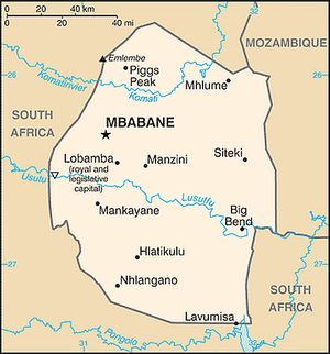
| Capital | Mbabane; NB- Lobamba is the political-royal capital |
| Government | Kingdom; independent member of the Commonwealth |
| Coin | Lilangeni (SZL), |
| Surface | total: 17,363 km2 water: 160 km2 country: 17,203 km2 |
| Population | 1.123.605 |
| Language | siSwati (official), English (official, political and business language) |
| Religion | Zionist (a mix of Christianity and native ancient prayers) 40%, Roman Catholic 20%, Muslim 10%, Anglican, Bahai, Methodist, Mormon, Jewish and others 30% |
| Call code | 268 |
| Internet TLD | .sz |
| Time zone | UTC 2 |
Swaziland or eswatini, officially it Kingdom of Eswatini, is a country in southern Africa.
Info
History
climate
In general, rain usually falls during the summer months, often in the form of thunderstorms. Winter is the dry season. Annual rainfall is highest on the Highveld in the west, between 1000 and 2000 mm, depending on the year. The further east, the less rain, with the Lowveld recording 500 to 900mm per year. Variations in temperature are also related to the elevation of the different regions. The Highveld temperature is moderate and, rarely, uncomfortably hot, while the Lowveld can take temperatures around 40 degrees in summer.
Geography
Swaziland is a small country landlocked by South Africa and Mozambique. It is a country with many rivers, which farmers use to grow fruit and sugar cane.
Population
Art & Culture
Holidays
Regions

Towns
Other destinations
Arrive
Passport and visa
Have foreigners from the following countries / territories no Visa required for a stay of 30 days or less: Andorra, Antigua and Barbuda, Argentina, Australia, Bahamas, Barbados, Belgium, Bosnia Herzegovina, Botswana, Brazil, Canada, Chile, Croatia, Cyprus, Czech Republic, Denmark, Germany, East -Timor, Estonia, Fiji, Finland, France, Gambia, Ghana, Greece, Grenada, Guyana, Hungary, Iceland, Ireland, Israel, Italy, Jamaica, Japan, Kenya, Latvia, Lesotho, Lithuania, Luxembourg, Madagascar, Malawi, Malaysia , Malta, Mauritius, Monaco, Mozambique, Namibia, Netherlands, New Zealand, Norway, Austria, Papua New Guinea, Poland, Portugal, Russia, Samoa, San Marino, Serbia, Seychelles, Sierra Leone, Singapore, Slovenia, Solomon Islands, Spain, Taiwan, Tanzania, Tonga, Trinidad and Tobago, Turkey, Tuvalu, Uganda, Ukraine, Uruguay, United Kingdom, United States, Zambia, Zimbabwe, South Africa, South Korea, Sweden and Switzerland.
By plane
The only international airport in Eswatin is King Mswati III International Airport (IATA: SHO), also called Sikhuphe (replacing Matsapha Airport, which was about 1 km north of Manzini, a few kilometers west of the highway connecting Manzini to Mbabane). Airlink Swaziland offers flights from Johannesburg and Durban (South Africa).
By car
Depending on the season, the border crossings from South Africa to Swaziland can be busy. The Ngwenya/Oshoek border post (on the N17 from Ermelo to Mbabane) is usually crowded around long weekends and holidays, as it is the most popular border post.
By bus
Most public transport bus connections arrive in Mbabane or Manzini. Smaller bus lines or minibuses usually run to Johannesburg, Durban or Cape Town in South Africa and Maputo in Mozambique.
Larger buses usually run within the country and some stop at border crossings where passengers must connect on an onward journey unless a specific group reservation is made to hire a large bus.
All minibuses to South Africa go directly to the bus stations In Johannesburg.
Travel around
By plane
By train
By car
By bus
By boat
Language
- siSwati (official)
- English (official, political and business language)
To look at
To do
To buy
Cost
Food
Going out
stay overnight
To learn
To work
Safety
Health
respect
Contact
| Countries in Africa | ||||||||||||
|---|---|---|---|---|---|---|---|---|---|---|---|---|
|
| Destinations | ||||||||
|---|---|---|---|---|---|---|---|---|
|