| Burkina Faso | |
 | |
Location  | |
Coat of arms and flag  | |
| Capital | Ouagadougou |
|---|---|
| Government | Semi-presidential republic |
| Currency | UEMOA CFA Franc (XOF) |
| Surface | 274,200 km² |
| Inhabitants | 15.224.780 (2009) |
| Tongue | French |
| Religion | Islam (50%), Christianity (30%) and Animism (20%) |
| Electricity | 220V / 50Hz (European socket) |
| Prefix | 226 |
| TLD | .bf |
| Time zone | UTC |
| Website | Burkina Faso Tourist Board |
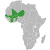
Burkina Faso is a state ofWest Africa
To know
Burkina Faso borders the Mali to the north, the Togo and the Ghana to the south, the Ivory Coast to the southwest, the Benin to the southeast and the Niger East. In 1960 it gained independence from France and became the Upper Volta Republic. The current name, Burkina Faso, was established on August 4, 1984 by revolutionary president Thomas Sankara, and means the land of upright men.
Geographical notes
The average altitude of Burkina Faso is 400 m; it is therefore a relatively flat region. The southwest is instead dominated by a sandstone massif; here is the highest peak in the country, Ténakourou (749 m a.s.l.). The edges of the massif are made up of steep escarpments, with gradients of up to 150 m.
The old name of the town, Alto Volta, was due to four important rivers that cross the territory: the Comoé, the Mouhoun (previously called Volta Nero), the Nakambé ("White Volta") and the Nazinon ("Red Volta") . The Mouhoun and the Comoé are the only two waterways with the presence of water all year round.
The Niger River basin makes up 27% of the country's surface. The tributaries (Béli, Gorouol, Goudébo and Dargol) have a seasonal pattern; they are dry for about half of the year, but they can also cause significant flooding.
Among the numerous lakes of Burkina Faso, the main ones are Tingrela, Bam and Dem, in addition to the large basins of Oursi, Béli, Yomboli and Markoye.
When to go
To choose when to go to Burkina Faso it is advisable to keep in mind that the climate is mainly tropical, with two distinct seasons: the rainy season, from May-June to September (shorter in the north), with rainfall between 600 and 900 mm ; and the dry season, in which the harmattan blows, a dry and hot wind from the Sahara.
Background
The first human traces date back to the prehistoric period ranging from 12,000 to 5,000 BC. Between the 15th and 16th centuries AD. the Burkina Faso region was one of the most important economic centers of the Songhai empire. The French began colonizing the Burkina Faso region in 1896, subduing the Mossi kingdom of Ouagadougou, transforming it first into a protectorate and then into a full-fledged colony. The territory was annexed and dismembered several times to other heterogeneous territories by the French for political reasons, until 5 August 1960, the date on which it gained independence.
Spoken languages
The official language is French, spoken by the majority of the population (in some villages, women and children do not speak it). blackberry language for the mossi and the dioula for the homonymous ethnic group (widespread in particular in the Bobo Djoulasso area). On the border with Mali, in particular towards Gorom-Gorom, there are nomads of the Peul ethnic group who speak the homonymous language.
Suggested readings
- David Sudlow, The Tamasheq of North-East Burkina Faso, Köln, Köppe, 2001 - ISBN 3-89645-380-7
- Carlo Batà "Thomas Sankara's Africa" - Ahab editions
- Vittorio Martinelli with Sofia Massai, The voice in the desert, Publishing Area, 2009
- Alessandro Aruffo, "Sankara", Massari Editore 2007
Territories and tourist destinations
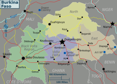
Urban centers
- Ouagadougou, Known as Ouaga (pronounced: "Wa-Gha") - The capital, located in the center of the country, in the area known as Mossi Plateau.
- Banfora - Starting point for relaxing in the pleasant Karfiguela waterfalls, where you can dip your feet in the water and bathe in small natural pools. In the nearby Lake Tengrela where the homonymous ethnic group lives, it is possible to navigate the placid waters to spot hippos.
- Bobo-Dioulasso - The second largest city in the country located in the southwest. Capital of culture and music, in the streets it is easy to hear percussionists and Afro melodies from improvised artists. Do not miss the visit of the “Grande Mosquée”, a beautiful example of Sahelian architecture in mud bricks with conical towers bristling with wooden spikes. Then the adjacent district of Kibidwe, the oldest part of the city and always on foot the "Grand Marché" to get lost among the countless stalls crammed into the covered alleys that sell everything, there is also an interesting area dedicated to handicrafts, mostly made of wood.
- Dédougou
- Fada N'Gourma - Access point for the Southeast National Park. In addition, the city is famous for Fada honey, easily available in the markets.
- Gaoua - not quite a pleasant city but it is close to Loropéni ruins, a heritage ofUNESCO.
- Koudougou
- Ouahigouya
Other destinations
- Arli National Park
- Kaboré Tembi National Park - Ancient reserve of Little, south of Ouagadougou.
- National Park W - Cross-border park (with Niger is Benin) and assets ofUNESCO.
How to get
Entry requirements
Yellow fever vaccination is mandatory for all travelers, regardless of where they come from. An entry visa is required at theBurkinabé Embassy in Italy. which is located at Rome, are required for obtaining 3 passport photos, a completed form in 3 copies, and has a cost of 35 euros valid for a single entry.
Controls at the arriving airport are quite strict; remember to fill in the entry form before having it checked by the police because it happened that after completing it you are asked for a "tip".
By plane
Italy is not directly connected with the international airport of Ouagadougou, it is necessary to call at Tripoli, Algiers, Paris, Addis Ababa, Abidjan or Casablanca.
The connections to Ouagadougou are daily with AirFrance (stopover in Paris) or Turkish Airlines (stopover in Istanbul), or weekly with Air Algerie (stopover in Algiers). Almost all flights make an additional stopover to embark or disembark passengers at Niamey, capital of Niger, one hour flight from Ouagadougou but also one time zone forward.
How to get around
On the train
There is no real railway system, as the only link is the one that connects Abidjan in Ivory Coast to Ouagadougou.
By car
Any movement must be done by rented car with driver.
By bus
In Burkina Faso we do not recommend public transport as they are very little present, in poorly maintained conditions and do not travel large distances.
What see
- Tiebélé - The village is located in the southern part of the country, 40 km east of Pô, in the region inhabited by the Gourounsi ethnic group. It is an unforgettable village since almost all the houses, called "sukhala", without windows, are adorned with symbols typical of the animist tradition (eg geometric designs, stylized objects and animals), whose prominent colors are ocher and black. . The houses have shapes (e.g. square, round, etc.) that differ according to the social class of those who live there. Each house has small and narrow doors but some of them are nothing short of wonderful. The architects of this singular artistic expression are women, who use guinea fowl feathers to paint.
- Gorom Gorom Market - Thursday is the day of the famous market which starts to come alive around 11 in the morning. What is most striking is the mix of present and easily distinguishable ethnic groups: Tuareg, Peul, Bella and Mossi. Cattle traders can also be found Ghanaians. Do not miss the market reserved for the trafficking of animals located 1 km to the north, where you can find whole herds of goats, zebus and camels. This market will be able to stimulate all your senses, through: the cries of the various animals, the bright colors of the fabrics (worn and sold), the characteristic red dust, the people and the presence of the looming Sahara.
- Bani - In this dusty and remote village of the Sahel 60 km from Dori, you will find the "7 mosques", in typical Sudanese style the architectural complex of buildings is truly amazing, both for its beauty and for its grandeur. There are 7, since they represent a man with his foot crossed seen from above: the largest and well-kept must represent the head, while another 2 the shoulders, another 2 the hands and another 2 the feet. These last 6 have the minarets collapsed following unexpected heavy rains for these places, they rise on a plateau, dusty and constantly whipped by the wind. The small village of Bani, where it is impossible to stop to eat and difficult to find drinking water, is made up of a few mud huts built close to the Great Mosque.
- Oursi - A remote village, 40 km north of Gorom Gorom, represents the natural border between the desert and the Sahel. In fact, this is where the sand dunes begin, against which local farmers and peasants struggle every day to preserve their poor possessions.
- Obire - Near the mysterious ruins of Loropeni (a strange rock with particular engravings), stands the village of Obire, known to be the capital of the Gan tribe. You can easily meet the ruler of the Gan, and it is certainly worth visiting the sanctuary of the Gan Kings: in a clearing, among the tall grass and under a huge mango, there are 12 red brick houses that preserve the tombs of the Kings , currently represented by mud statues decorated with cauri. The King holds the Grand Council in this very place, so that the Kings of the past can also be witnesses. The Gans come from Ghana, fled when the Ashanti empire was at its peak, so much so that women still retain that ancestral wisdom in gold processing.
- Dafra - It is not a village but a lost pond in an enchanting canyon in the countryside around Bobo Dioulasso. Here, propitiatory sacrifices are constantly repeated for any problem; the Grand Feticiur sacrifices an animal, usually a chicken or a goat, reads its entrails, and then feeds them to monstrous catfish living in the small pond.
- Ouahabou - On the only route that connects the capital with Bobo Dioulasso, you can visit the mosque of Ouahabou, a typical example of Sudanese architecture located in a desolate place, where its yellow ocher contrasts with the blue sky.
- Boni - In this village on the road to Bobo Dioulasso from Ouagadogou, a singular church was built since its facade is a mask, it seems to testify to the perfect synthesis between the colorful Afro culture and the more austere one of Catholicism.
What to do
Currency and purchases
 UEMOA - Acceding countries map 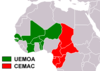 CFA Franc - Map of participating countries |
|  ECOWAS - Map of participating countries 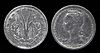 1 CFA Franc coin |
Below are the links to know the current exchange rate with the main world currencies:
| (EN) With Google Finance: | AUDCADCHFEURGBPHKDJPYUSD |
| With Yahoo! Finance: | AUDCADCHFEURGBPHKDJPYUSD |
| (EN) With XE.com: | AUDCADCHFEURGBPHKDJPYUSD |
| (EN) With OANDA.com: | AUDCADCHFEURGBPHKDJPYUSD |
Local produce can be found at a good price, but since many of the goods are imported, there is not always the convenience that one would expect.
At the table
Local food is also appreciated by Westerners, and does not differ much from some dishes that can also be found in North Africa. A kind of small grain rice is often served as couscous, mixed with vegetables with meat or fish (fat riz) or tomato and onion sauce (riz tomate), then there are often also an acceptable pizza, salads, excellent local onions, fruit (especially mango, bananas and papaya), and sandwiches, hamburgers or various fries.
Drinks
Mostly soft drinks and fruit juices, but there are two very good local beers, the Brakina, and especially the Beaufort, really good even by our standards. There is also imported French wine.
Tourist infrastructure
A few good quaint restaurants and tons of microscopic residents' restaurants are the kind of places to eat that you come across. The level of hygiene of the restaurants for the premises is not guaranteed, especially in the washing of food and dishes.
There are generic hotels in the city center, with most of the comforts except the most modern ones, slightly decayed in maintenance and with a courteous but very slow service, and also inundated with smog and traffic noise. Then there are many characteristic bed & breakfasts, highly recommended. Low prices.
Events and parties
National holidays
| Date | Festivity | Note | |
|---|---|---|---|
| January | New Year | International holiday | |
| January | Revolution party | Coup d'état anniversary (1966) | |
| March | Women's day | International holiday | |
| March April | Easter | Christian holiday | |
| May | Workers Day | International holiday | |
| May June | Ascension Day | Christian holiday | |
| August | Independence Day | Independence from France (1960) | |
| August | Assumption | Christian holiday | |
| November | All Saints | Christian holiday | |
| December | Republic Day | Memorial of the birth of the semi-autonomous republic under French rule (1958) | |
| December | Christmas | Christian holiday that marks the birth of Christ | |
| muharram | Ras as-Sana | Muslim holiday that marks the beginning of the Islamic New Year | |
| rabi 'al-awwal | Mawlid | Muslim holiday that marks the birth of the Prophet Muhammad | |
| shawwal | Id al-fitr | Muslim holiday that marks the end of Ramadan | |
| dhul-hijja | Id Al Adha | Muslim festival of sacrifice or ram also called Tabaski or Id El Kabir (great festival) | |
Being a nation with a strong Muslim presence, in addition to the Christian ones, the anniversaries of Islam are also celebrated.
Safety
Before embarking on the journey consult:
- Safe travel - Ministry of Foreign Affairs (Farnesina) (Country safety information).
Burkina is a quiet country and you don't get harassed on the street unless you meet drunkards. Few beggars, and in any case not insistent. Beware that the street lighting is approximate, and the scooters sometimes do not have lights, and nevertheless they go fast even at night on dirt roads without giving priority to anyone. Be careful when crossing the road, the moped traffic is fierce and the rules are not always respected.
Health situation
In addition to a few facilities in the capital, health facilities in the country are backward. Malaria prophylaxis, vaccinations against hepatitis A and B, measles and meningitis are recommended, and yellow fever is mandatory, which you will be asked for at the airport. Finally, it is recommended to use repellent products.
Respect the customs
Ramadan is the ninth and holiest month in the Islamic calendar and lasts 29-30 days. Muslims fast every day for its entire duration and most restaurants will be closed until dusk. Nothing (including water and cigarettes) should pass through the lips from sunrise to sunset. Foreigners and travelers are exempt, but should still refrain from eating or drinking in public as it is considered rude. Working hours are also decreasing in the corporate world. The exact dates of Ramadan depend on local astronomical observations and may vary from country to country. Ramadan ends with the feast of Eid al-Fitr, which can take several days, usually three in most countries.
- 13 April - 12 May 2021 (1442 AH)
- 2 April - 1 May 2022 (1443 AH)
- 23 March - 20 April 2023 (1444 AH)
- 11 March - 9 April 2024 (1445 AH)
- 1 March - 29 March 2025 (1446 AH)
If you are planning to travel to Burkina Faso during Ramadan, consider reading the article Traveling during Ramadan.
Burkina is a fairly conservative country, and skimpy or too "naked" clothing is not common, not even for men, who almost always wear long trousers, shoes and long-sleeved shirts even in the most atrocious heat. Very rare to see a person with bare chest or in shorts, or a woman in a miniskirt or stiletto heels in Burkina. Nevertheless, the Burkinabè society is rather liberal and in the evening, in various clubs, local women and men can be seen dancing, drinking, eating and having fun happily to the sound of live orchestras.
How to keep in touch
Telephony
Good cellular telephony is ensured by a couple of local operators. It is worth buying a local sim to call in Europe.
Internet
The internet connection is good ad Ouagadougou, the capital.
Other projects
 Wikipedia contains an entry concerning Burkina Faso
 Commons contains images or other files on Burkina Faso
 Wikinews contains current news on Burkina Faso
![]() Algeria ·
Algeria · ![]() Angola ·
Angola · ![]() Benin ·
Benin · ![]() Botswana ·
Botswana · ![]() Burkina Faso ·
Burkina Faso · ![]() Burundi ·
Burundi · ![]() Cameroon ·
Cameroon · ![]() Cape Verde ·
Cape Verde · ![]() Chad ·
Chad · ![]() Comoros ·
Comoros · ![]() Ivory Coast ·
Ivory Coast · ![]() Egypt ·
Egypt · ![]() Eritrea ·
Eritrea · ![]() eSwatini ·
eSwatini · ![]() Ethiopia ·
Ethiopia · ![]() Gabon ·
Gabon · ![]() Gambia ·
Gambia · ![]() Ghana ·
Ghana · ![]() Djibouti ·
Djibouti · ![]() Guinea ·
Guinea · ![]() Guinea-Bissau ·
Guinea-Bissau · ![]() Equatorial Guinea ·
Equatorial Guinea · ![]() Kenya ·
Kenya · ![]() Lesotho ·
Lesotho · ![]() Liberia ·
Liberia · ![]() Libya ·
Libya · ![]() Madagascar ·
Madagascar · ![]() Malawi ·
Malawi · ![]() Mali ·
Mali · ![]() Morocco ·
Morocco · ![]() Mauritania ·
Mauritania · ![]() Mauritius ·
Mauritius · ![]() Mozambique ·
Mozambique · ![]() Namibia ·
Namibia · ![]() Niger ·
Niger · ![]() Nigeria ·
Nigeria · ![]() Central African Republic ·
Central African Republic · ![]() Republic of the Congo ·
Republic of the Congo · ![]() Democratic Republic of Congo ·
Democratic Republic of Congo · ![]() Rwanda ·
Rwanda · ![]() São Tomé and Príncipe ·
São Tomé and Príncipe · ![]() Senegal ·
Senegal · ![]() Seychelles ·
Seychelles · ![]() Sierra Leone ·
Sierra Leone · ![]() Somalia ·
Somalia · ![]() South Africa ·
South Africa · ![]() Sudan ·
Sudan · ![]() Southern Sudan ·
Southern Sudan · ![]() Tanzania ·
Tanzania · ![]() Togo ·
Togo · ![]() Tunisia ·
Tunisia · ![]() Uganda ·
Uganda · ![]() Zambia ·
Zambia · ![]() Zimbabwe
Zimbabwe
States de facto independent: ![]() Somaliland
Somaliland
Territories with status indefinite: ![]() Western Sahara
Western Sahara
Addictions French: ![]() Mayotte ·
Mayotte · ![]() Meeting ·
Meeting · ![]() Scattered islands of the Indian ocean
Scattered islands of the Indian ocean
Addictions British: ![]() Saint Helena, Ascension and Tristan da Cunha
Saint Helena, Ascension and Tristan da Cunha
African territories Italians: ![]() Lampedusa ·
Lampedusa · ![]() Street lamp
Street lamp
African territories Portuguese: ![]() Madeira (
Madeira (![]() Wild Islands)
Wild Islands)
African territories Spaniards: ![]() Ceuta ·
Ceuta · ![]() Canary Islands ·
Canary Islands · ![]() Melilla ·
Melilla · ![]() Plazas de soberanía (Chafarinas · Peñón de Alhucemas · Peñón de Vélez de la Gomera · Perejil)
Plazas de soberanía (Chafarinas · Peñón de Alhucemas · Peñón de Vélez de la Gomera · Perejil)