| Cameroon | |
 | |
Location 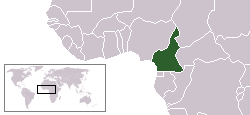 | |
Coat of arms and flag  | |
| Capital | Yaoundé |
|---|---|
| Government | presidential republic |
| Currency | Central African CFA Franc (XAF) |
| Surface | 475,442 km² |
| Inhabitants | 20.129.878 (2012 estimate) 17.463.836 (2005 census) |
| Tongue | French is English |
| Religion | Christianity (70%), (Islam 21%), Animism (6%) and the rest atheists or minor religions (2010) |
| Electricity | 220V / 50Hz (European socket) |
| Prefix | 237 |
| TLD | .cm |
| Time zone | UTC 1 |
| Website | Cameroon Tourist Office[link previously not working] |
The Cameroon is a state ofWest Africa facing west on the Gulf of Guinea, bordering on the northwest with the Nigeria, to the northeast with the Chad, to the east with the Central African Republic, southeast with the Republic of the Congo, and to the south with the Gabon and the Equatorial Guinea.
To know
The name of the town dates back to 1472, the year in which the Portuguese sailors reached the coast, and given the abundance of shrimp in the River Wouri they named the region Rio dos Camarões, Portuguese term for "River of Prawns", hence the term Cameroon.
Geographical notes
Its territory stretches for almost 1,000 kilometers from the regions of Sudanese Africa almost to the equator and sees a remarkable variety of climates and environments, ranging from the arid savannah of the north, to the wooded savannah in the central areas, to the lush equatorial rainforests. of the center and south. The territory consists for the most part of a vast undulating plateau, which covers almost the entire central and southern region; floodplains extend along the Atlantic coast and into the north, where the relief slopes down to the depression of Lake Chad.
The territory of Cameroon is divided into four catchment areas:
- The rivers that flow towards the southwest, flowing into the Gulf of Guinea, the main ones of which are Ntem, Nyong, Sanaga, and Wouri.
- The Dja and the Kadéï that flow eastward to meet the Congo River.
- The Benue River to the north which flows north and then west, becoming a tributary of the Niger River.
- The Logone River that flows north, meeting Lake Chad, a lake that Cameroon shares with three other neighboring countries (Chad, Niger is Nigeria).
When to go
The best months to travel to Cameroon are December, January is February, which allow you to avoid the rainy season and the hottest months. The country actually has a great variety of landscapes and climates.
Background
Human settlement in the territory of today's Cameroon dates back to the Neolithic. The populations that populated the region the longest were the Pygmies and Baka. Although the Portuguese were the first Europeans to land on these territories, it was the Germans who colonized them in 1884, but after the First World War they were transferred to France, to then gain independence on 1 January 1960.
Spoken languages
Cameroon is a bilingual nation with French and English as the official languages. In reality, the signage is rarely in both languages and bilingualism means that some areas of the country are French-speaking and others English-speaking. Beyond the official languages, the country has an extraordinary cultural and linguistic richness. English is spoken in the two regions of the North-West and the South-West, bordering Nigeria, while the rest of the territory (comprising four fifths of the population) is French-speaking. In addition, there are more than 200 linguistic minorities including German, ewondo, douala, fufulde, ghomala ', baham, medùmbà, kom and others.
Suggested readings
- DeLancey Mark W., and Mark Dike DeLancey (2000): Historical Dictionary of the Republic of Cameroon (3rd ed.). Lanham, Maryland: The Scarecrow Press.
- Fanso, V. G. (1989). Cameroon History for Secondary Schools and Colleges, Vol. 1: From Prehistoric Times to the Nineteenth Century. Hong Kong: Macmillan Education Ltd.
- Fabian Nji, Cameroon, History Economy and Resources Society and Traditions Art and Culture Religion (1998) Pendragon Editions, Bologna
- Mark Dike DeLancey, Rebecca Neh Mbuh, Historical Dictionary of Cameroon, Scarecrow Press, 2010.
- Stefano Nori, "Cameroon, the land of a thousand villages", Polaris 2008
Territories and tourist destinations
Cameroon is divided into 10 regions. Each region is divided into departments, which are in turn subdivided into arrondissements.


Urban centers
Other destinations

- Kumbo
- Oku Lake - Inside the Ring Road.
- Mount Cameroon - The highest mountain in West Africa.
- Ngoketunjia
- Korup National Park
- Waza National Park - Biosphere protected byUNESCO, located in the north of the country.
- Ring Road - 360 km wide.
- Dja Faunal Reserve - It is part of the assets ofUNESCO.
- Tado Dairy Co-op
- Oku village
How to get
Entry requirements
Passport valid for at least 6 months, VISA that can be taken in Italy a Rome, Naples, Florence is Trieste. To obtain the visa, vaccination against yellow fever, 2 passport photos, the return ticket, the completed form, an invitation letter and 85 euros of contribution are mandatory. However, for more precise information, visit the website ofEmbassy of Cameroon.
How to get around
What see
What to do
Currency and purchases
 CEMAC - Map of participating countries 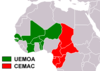 CFA Franc - Map of participating countries |
| 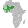 UEMOA - Acceding countries map 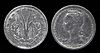 1 CFA Franc coin |
Below are the links to know the current exchange rate with the main world currencies:
| (EN) With Google Finance: | AUDCADCHFEURGBPHKDJPYUSD |
| With Yahoo! Finance: | AUDCADCHFEURGBPHKDJPYUSD |
| (EN) With XE.com: | AUDCADCHFEURGBPHKDJPYUSD |
| (EN) With OANDA.com: | AUDCADCHFEURGBPHKDJPYUSD |
At the table
Cameroonian cuisine differs from region to region and is generally quite spicy. The ntomba nam is the specialty of the city of Youndé. A peanut paste mixed with fish or meat cooked in banana leaves. The ndolé is the specialty of the city of Douala. It is a bitter vegetable with a large daughter that is washed numerous times to reduce the bitter taste, is then boiled in water, chopped up like a puree and then mixed with fish or meat. The kwen is the specialty of the center-north. It is made from cassava leaves, boiled in water and then chopped up like a puree. Kwen is a staple food for many families. Fish is the basis of the coastal diet, consumed mainly on the grill and flavored with chilli. The fish is served with ndolé, kwen or miondo. The million it is a long preparation of cassava which is peeled from raw and left to soften for 3-4 days in a barrel. It is then washed and crushed to transform it into a whitish paste. The pasta is then cut into strips and rolled in banana leaves. Millet is the staple food in the north. The nkui it is consumed in the west. It is a kind of sticky soup made from bark and seasonings, generally accompanied by corn patties. Apparently the recipe is generally considered to be terrible.
Drinks
Beer is among the most consumed drinks. There is also a production of local corn beer which is mainly produced on the coast and a production of palm wine, particularly in the areas of the west, the center and the coast. Drinking tap water is strongly discouraged.
Tourist infrastructure
Events and parties
The sheep festival is held annually on 21 May.
National holidays
| Date | Festivity | Note | |
|---|---|---|---|
| January | New Year | International holiday | |
| February | Youth party | National holiday announced in 1964. The president regularly gives a speech to young people. | |
| March April | Good Friday, Easter | Christian holiday | |
| May | Workers Day | International holiday | |
| May June | Ascension Day | Christian holiday | |
| May | National Unity Day | Memorial of the unification of the two federated states of Cameroon into the current republic of Cameroon (1972) | |
| August | Assumption | Christian holiday | |
| December | Christmas | Christian holiday that marks the birth of Christ | |
| muharram | Ras as-Sana | Muslim holiday that marks the beginning of the Islamic New Year | |
| rabi 'al-awwal | Mawlid | Muslim holiday that marks the birth of the Prophet Muhammad | |
| shawwal | Id al-fitr | Muslim holiday that marks the end of Ramadan | |
| dhul-hijja | Id Al Adha | Muslim festival of sacrifice or ram also known as Id El Kabir (great festival) | |
The independence celebrations of 1 January 1960 of French Cameroon from France and of 1 October 1961 of British Southern Cameroon from UK they are not formally celebrated.
Safety
Before embarking on the journey consult:
- Safe travel - Ministry of Foreign Affairs (Farnesina) (Country safety information).
The state is not dangerous, but travel to the far north of the country is not recommended due to the Islamic terrorist threat of Boko Haram. It is advisable to avoid walking in the evening and at night.
Health situation
The main health facilities of the major cities are well equipped and also able to treat tropical diseases. The yellow fever vaccine is mandatory for all travelers over the age of 1 year, finally, malaria prophylaxis and vaccines against typhus and hepatitis A and B are recommended.
Respect the customs
Ramadan is the ninth and holiest month in the Islamic calendar and lasts 29-30 days. Muslims fast every day for its entire duration and most restaurants will be closed until dusk. Nothing (including water and cigarettes) should pass through the lips from sunrise to sunset. Foreigners and travelers are exempt but should still refrain from eating or drinking in public as it is considered rude. Working hours are also decreasing in the corporate world. The exact dates of Ramadan depend on local astronomical observations and may vary from country to country. Ramadan ends with the feast of Eid al-Fitr, which can take several days, usually three in most countries.
- 13 April - 12 May 2021 (1442 AH)
- 2 April - 1 May 2022 (1443 AH)
- 23 March - 20 April 2023 (1444 AH)
- 11 March - 9 April 2024 (1445 AH)
- 1 March - 29 March 2025 (1446 AH)
If you are planning to travel to Cameroon during Ramadan, consider reading the article Traveling during Ramadan.
How to keep in touch
Other projects
 Wikipedia contains an entry concerning Cameroon
 Commons contains images or other files on Cameroon
 Wikinews contains current news on Cameroon
![]() Algeria ·
Algeria · ![]() Angola ·
Angola · ![]() Benin ·
Benin · ![]() Botswana ·
Botswana · ![]() Burkina Faso ·
Burkina Faso · ![]() Burundi ·
Burundi · ![]() Cameroon ·
Cameroon · ![]() Cape Verde ·
Cape Verde · ![]() Chad ·
Chad · ![]() Comoros ·
Comoros · ![]() Ivory Coast ·
Ivory Coast · ![]() Egypt ·
Egypt · ![]() Eritrea ·
Eritrea · ![]() eSwatini ·
eSwatini · ![]() Ethiopia ·
Ethiopia · ![]() Gabon ·
Gabon · ![]() Gambia ·
Gambia · ![]() Ghana ·
Ghana · ![]() Djibouti ·
Djibouti · ![]() Guinea ·
Guinea · ![]() Guinea-Bissau ·
Guinea-Bissau · ![]() Equatorial Guinea ·
Equatorial Guinea · ![]() Kenya ·
Kenya · ![]() Lesotho ·
Lesotho · ![]() Liberia ·
Liberia · ![]() Libya ·
Libya · ![]() Madagascar ·
Madagascar · ![]() Malawi ·
Malawi · ![]() Mali ·
Mali · ![]() Morocco ·
Morocco · ![]() Mauritania ·
Mauritania · ![]() Mauritius ·
Mauritius · ![]() Mozambique ·
Mozambique · ![]() Namibia ·
Namibia · ![]() Niger ·
Niger · ![]() Nigeria ·
Nigeria · ![]() Central African Republic ·
Central African Republic · ![]() Republic of the Congo ·
Republic of the Congo · ![]() Democratic Republic of Congo ·
Democratic Republic of Congo · ![]() Rwanda ·
Rwanda · ![]() São Tomé and Príncipe ·
São Tomé and Príncipe · ![]() Senegal ·
Senegal · ![]() Seychelles ·
Seychelles · ![]() Sierra Leone ·
Sierra Leone · ![]() Somalia ·
Somalia · ![]() South Africa ·
South Africa · ![]() Sudan ·
Sudan · ![]() Southern Sudan ·
Southern Sudan · ![]() Tanzania ·
Tanzania · ![]() Togo ·
Togo · ![]() Tunisia ·
Tunisia · ![]() Uganda ·
Uganda · ![]() Zambia ·
Zambia · ![]() Zimbabwe
Zimbabwe
States de facto independent: ![]() Somaliland
Somaliland
Territories with status indefinite: ![]() Western Sahara
Western Sahara
Addictions French: ![]() Mayotte ·
Mayotte · ![]() Meeting ·
Meeting · ![]() Scattered islands of the Indian ocean
Scattered islands of the Indian ocean
Addictions British: ![]() Saint Helena, Ascension and Tristan da Cunha
Saint Helena, Ascension and Tristan da Cunha
African territories Italians: ![]() Lampedusa ·
Lampedusa · ![]() Street lamp
Street lamp
African territories Portuguese: ![]() Madeira (
Madeira (![]() Wild Islands)
Wild Islands)
African territories Spaniards: ![]() Ceuta ·
Ceuta · ![]() Canary Islands ·
Canary Islands · ![]() Melilla ·
Melilla · ![]() Plazas de soberanía (Chafarinas · Peñón de Alhucemas · Peñón de Vélez de la Gomera · Perejil)
Plazas de soberanía (Chafarinas · Peñón de Alhucemas · Peñón de Vélez de la Gomera · Perejil)