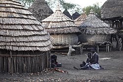
| Southern Sudan | |
 | |
Location .svg/250px-South_Sudan_in_its_region_(undisputed).svg.png) | |
Coat of arms and flag  | |
| Capital | Juba |
|---|---|
| Government | Federal presidential republic |
| Currency | South Sudanese Pound (SSP) |
| Surface | 619,745 km² |
| Inhabitants | 10.625.176 (2012 estimate) 8.260.490 (2008 census) |
| Tongue | English |
| Religion | Christianity (60.5%), Animism (34%), and the rest atheists or minor religions |
| Electricity | 230V / 50Hz (European and British plug) |
| Prefix | 211 |
| TLD | .ss |
| Time zone | UTC 3 |
| ATTENTION: Due to the civil war currently underway, South Sudan is to be considered a destination at risk for visitors, so any type of trip is strongly discouraged. Extremist groups have among their objectives the kidnapping of tourists throughout the country. The border with the Central African Republic it is extremely dangerous. (July 2012) | |
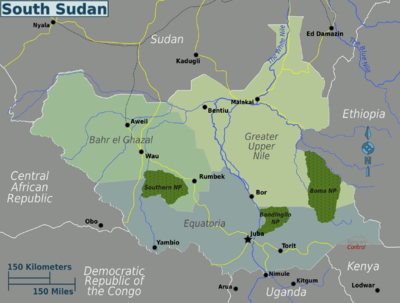
Southern Sudan is a state ofSouthern Africa which has no access to the sea and is bordered to the north by the Sudan, to the east with theEthiopia, south with the Kenya, L'Uganda and the Democratic Republic of Congo and to the west with the Central African Republic.
To know
The previous status of autonomous region and the institutional form were guaranteed by the Naivasha peace agreement of 2005 between the southern separatists and the central government, which ended the second Sudanese civil war, one of the longest on the African continent: in based on the peace agreement, in January 2011 a regional referendum was held for independence from the rest of the Sudanese federation, which led, on 9 July 2011, to the complete independence of the country. The new country was officially admitted to the UN on July 14, 2011, becoming its 193rd member state.
Geographical notes
Unlike the Sudan, most of the state's territory is covered by tropical forests, swamps and meadows. There are many nature reserves that host migratory species in large numbers, such as the Bandingilo National Park and the Boma National Park. The main river is the White Nile. According to the WWF, there are several ecoregions in South Sudan: the Eastern Sudanese Savannah (savannah), the North Congo Forest (tropical forest), the Sudd (swamps) and the East African Montane Forests (forests).
Background
At the end of the 19th century the British colonized the Sudan which at the time also included South Sudan. In 1956 Sudan gained independence from UK. On 9 July 2011, thanks to a referendum that won the favor of almost 99% of the voters, South Sudan gained independence from Sudan.
Spoken languages
In addition to the official language, theArabic which acts in some situations as lingua franca and about 60 other indigenous languages, the main ones being: Dinka, Nuer, Bari and Zande.
Suggested readings
- Wyndham, R., 1936, The Gentle Savage, A Journey in the Province of Bahr El Ghazal, commonly known as 'The Bog', (New York: William Morrow and Company).
- Roberto Pattarin and Roberto Salgo, Equatoria 12º parallel. South Sudan between past and present, Silvana Editoriale, Cinisello Balsamo (MI), 2008
- Biel Melha Rout, Southern Sudan after the Comprehensive Peace Agreement, Netzbandt Verlag publisher, Jana, 2007 (ISBN 9783937884011)
- Panozzo Irene, The drama of Sudan, a mirror of Africa, EMI publisher, Bologna, 2000 (ISBN 9788830709379)
- Panozzo Irene, Sudan, the words to know, Editori Riuniti, Rome, 2005 (ISBN 9788835956297)
Territories and tourist destinations
South Sudan is made up of ten governorates (wilāyāt), grouped into the three historical provinces (mudīriyyāt) of Bahr al-Ghazal, Equatoria, and Upper Nile. The 10 states are in turn subdivided into 86 counties, in turn subdivided into Payamas, and the Payamas in Bomas.
Urban centers

- Juba - The capital of the country.
- Aweil (Uwail or Uwayl) - Capital of Northern Bahr al-Ghazal.
- Bentiu - Capital of the Unification, located 750 km from the Sudanese capital of Khartoum and located on the southern banks of the Bahr el Ghazal river.
- Malakal - Capital of the Upper Nile, located on the banks of the White Nile, just north of its confluence with the Sobat River.
- Rumbek - Capital of Laghi and old capital of the country.
- Wāw (Arabic: واو Wou; also Wow or Waw) - Capital of the Western Bahr al-Ghazal located on the west bank of the Jur River. It is the second largest city in the country.
- Yambio - Capital of the Western Equatoria, located near the border with Congo.
Other destinations
- Southern National Park - Located in the region Bahr al-Ghazal.
- Bandingilo National Park - Located in the region Equatoria.
- Boma National Park - Located in the region ofUpper Nile.
- Nimule National Park - Located in the region Equatoria near the homonymous city.
How to get
Entry requirements
Passport and entry visa. Being a newly formed country, South Sudan has few embassies abroad, currently the one competent for Italian citizens is located in Brussels, even if, the only ones that issue VISA are those of Nairobi in Kenya is Kampala in Uganda.
By plane
Currently there are no scheduled flights connecting the country with states outside the African continent, therefore it is necessary to make at least one stopover in a neighboring state. The main stopovers to reach Juba I'm: Cairo (Egypt), Addis Ababa (Ethiopia), Entebbe (Uganda), Nairobi (Kenya) is Khartoum (Sudan).
On the train
There is only one railway line in South Sudan that connects the Sudan to the city of Wāw. Please note that the border between Sudan and South Sudan is often closed due to internal problems, so before embarking on a train journey it is always good to contact the Sudan Railways Corporation [1] for more information.
How to get around

What see
What to do
Currency and purchases
The national currency is the South Sudanese pound (SSP) Here are the links to know the current exchange rate with the main world currencies:
| (EN) With Google Finance: | AUDCADCHFEURGBPHKDJPYUSD |
| With Yahoo! Finance: | AUDCADCHFEURGBPHKDJPYUSD |
| (EN) With XE.com: | AUDCADCHFEURGBPHKDJPYUSD |
| (EN) With OANDA.com: | AUDCADCHFEURGBPHKDJPYUSD |
At the table
The Nuer tribes eat mainly beef, goats, cow's milk, mango and Sorghum, cooked in three ways:
- kop, finely chopped and boiled
- wal wal, chopped and boiled to a solid consistency poriridge
- injera, like flour for leavened bread with yeast.
Drinks
The best known local beer is White Bull distributed by SAB Miller.
Tourist infrastructure
The hotels, with some exceptions a Juba, they are very lacking.
Events and parties
National holidays
| Date | Festivity | Note | |
|---|---|---|---|
| January | Independence Day | Independence from UK (1956). | |
| January | Peace agreement party | Memorial of the peace agreement signed in Nairobi (2005) | |
| March April | Easter | Christian holiday | |
| May | Workers Day | International holiday | |
| May | Day of the Sudan People's Liberation Army (SPLA) | SPLA founding memorial (1983) | |
| July | Martyrs day | Memorial to the death of politician and guerrilla John Garang who led the SPLA (2005) | |
| December | World AIDS Day | Global Awareness for AIDS Prevention (1988) | |
| December | Christmas | Christian holiday that marks the birth of Christ | |
| December | Saint Stephen | Christian holiday | |
| muharram | Ras as-Sana | Muslim holiday that marks the beginning of the Islamic New Year | |
| rabi 'al-awwal | Mawlid | Muslim holiday that marks the birth of the Prophet Muhammad | |
| shawwal | Id al-fitr | Muslim holiday that marks the end of Ramadan | |
| dhul-hijja | Id Al Adha | Muslim festival of sacrifice or ram also called Tabaski or Id El Kabir (great festival) | |
Safety
Before embarking on the journey consult:
- Safe travel - Ministry of Foreign Affairs (Farnesina) (Country safety information).
The whole country is very dangerous due to the ongoing conflict, in particular Jonglei and the Eastern Equatoria. The capital Juba it can be considered less dangerous, however episodes of petty crime with the use of firearms are frequent.
Health situation
Health facilities are inadequate and below Western standards. The diseases present are varied and in particular increase due to the situation created by the ongoing war, vaccinations against: yellow fever, meningitis, hepatitis A and B, typhus and cholera are recommended. Finally, antimalarial prophylaxis is recommended
Respect the customs
How to keep in touch
Other projects
 Wikipedia contains an entry concerning Southern Sudan
 Commons contains images or other files on Southern Sudan
 Wikinews contains current news on Southern Sudan
![]() Algeria ·
Algeria · ![]() Angola ·
Angola · ![]() Benin ·
Benin · ![]() Botswana ·
Botswana · ![]() Burkina Faso ·
Burkina Faso · ![]() Burundi ·
Burundi · ![]() Cameroon ·
Cameroon · ![]() Cape Verde ·
Cape Verde · ![]() Chad ·
Chad · ![]() Comoros ·
Comoros · ![]() Ivory Coast ·
Ivory Coast · ![]() Egypt ·
Egypt · ![]() Eritrea ·
Eritrea · ![]() eSwatini ·
eSwatini · ![]() Ethiopia ·
Ethiopia · ![]() Gabon ·
Gabon · ![]() Gambia ·
Gambia · ![]() Ghana ·
Ghana · ![]() Djibouti ·
Djibouti · ![]() Guinea ·
Guinea · ![]() Guinea-Bissau ·
Guinea-Bissau · ![]() Equatorial Guinea ·
Equatorial Guinea · ![]() Kenya ·
Kenya · ![]() Lesotho ·
Lesotho · ![]() Liberia ·
Liberia · ![]() Libya ·
Libya · ![]() Madagascar ·
Madagascar · ![]() Malawi ·
Malawi · ![]() Mali ·
Mali · ![]() Morocco ·
Morocco · ![]() Mauritania ·
Mauritania · ![]() Mauritius ·
Mauritius · ![]() Mozambique ·
Mozambique · ![]() Namibia ·
Namibia · ![]() Niger ·
Niger · ![]() Nigeria ·
Nigeria · ![]() Central African Republic ·
Central African Republic · ![]() Republic of the Congo ·
Republic of the Congo · ![]() Democratic Republic of Congo ·
Democratic Republic of Congo · ![]() Rwanda ·
Rwanda · ![]() São Tomé and Príncipe ·
São Tomé and Príncipe · ![]() Senegal ·
Senegal · ![]() Seychelles ·
Seychelles · ![]() Sierra Leone ·
Sierra Leone · ![]() Somalia ·
Somalia · ![]() South Africa ·
South Africa · ![]() Sudan ·
Sudan · ![]() Southern Sudan ·
Southern Sudan · ![]() Tanzania ·
Tanzania · ![]() Togo ·
Togo · ![]() Tunisia ·
Tunisia · ![]() Uganda ·
Uganda · ![]() Zambia ·
Zambia · ![]() Zimbabwe
Zimbabwe
States de facto independent: ![]() Somaliland
Somaliland
Territories with status indefinite: ![]() Western Sahara
Western Sahara
Addictions French: ![]() Mayotte ·
Mayotte · ![]() Meeting ·
Meeting · ![]() Scattered islands of the Indian ocean
Scattered islands of the Indian ocean
Addictions British: ![]() Saint Helena, Ascension and Tristan da Cunha
Saint Helena, Ascension and Tristan da Cunha
African territories Italians: ![]() Lampedusa ·
Lampedusa · ![]() Street lamp
Street lamp
African territories Portuguese: ![]() Madeira (
Madeira (![]() Wild Islands)
Wild Islands)
African territories Spaniards: ![]() Ceuta ·
Ceuta · ![]() Canary Islands ·
Canary Islands · ![]() Melilla ·
Melilla · ![]() Plazas de soberanía (Chafarinas · Peñón de Alhucemas · Peñón de Vélez de la Gomera · Perejil)
Plazas de soberanía (Chafarinas · Peñón de Alhucemas · Peñón de Vélez de la Gomera · Perejil)