| Central African Republic | |
 | |
Location  | |
Coat of arms and flag  | |
| Capital | Bangui |
|---|---|
| Government | presidential republic |
| Currency | Central African CFA Franc (XAF) |
| Surface | 622,984 km² |
| Inhabitants | 4.422.000 (2009 estimate) 3.895.150 (2003 census) |
| Tongue | French (official), Sango, local languages |
| Religion | Christianity (80.3%) Islam (10.1%), Animism (9.6%) (2003) |
| Electricity | 220V / 50Hz (European socket) |
| Prefix | 236 |
| TLD | .cf |
| Time zone | UTC 1 |
| ATTENTION: The Central African Republic is going through one of the most serious crises at the international level. The security situation in the country, including the capital Bangui, is extremely deteriorated. They continue to register, especially outside Bangui, inter-religious clashes and clashes between militias of opposing Muslim and Christian factions. Assault, vandalism and banditry are commonplace throughout the country, including Bangui. We therefore advise against travel, for any reason whatsoever, to the Central African Republic. All the more so due to the situation of instability and insecurity, the country is exposed to the risk of infiltration by elements and is therefore not immune to terrorist phenomena. (August 2014) | |
Central African Republic is a state ofCentral Africa which borders to the north with the Chad, to the east with the Sudan and the Southern Sudan, to the south with the Democratic Republic of Congo and the Republic of the Congo and to the west with the Cameroon. It is a landlocked state.
To know

Central Africa is one of the richest countries in the world in terms of biological diversity. It has a great variety of biotopes: from the shrubby savannah of the northeast to the primary rainforest of the south-southwest. Consequently, there are many plant and animal species that it hosts.
In the past it was a French colony with the name of Ubangi Shari; assumed its current name upon independence, in 1960.
The Central African Republic is one of the poorest countries on Earth.
Geographical notes
The territory of the Central African Republic consists of a plateau on which isolated mountain groups rise to the north-east and north-west. The plateau separates the catchment area of Lake Chad to the north from that of the Congo River to the south.
The waterways are numerous and in the rainy periods they increase their flow to cause floods.
Rainfall increases from north to south, resulting in the transition from savannah to rainforest.
Background
The region occupied by the Central African Republic has been inhabited since ancient times: various findings testify to the existence of ancient civilizations prior to the birth of the Egyptian Empire.
The first Europeans to arrive in the territory in 1885 were the French and Belgians and in 1910 it became one of the four territories of the Federation of French Equatorial Africa. On 1 December 1958 the Central African Assembly declared the birth of the Central African Republic within the French Community, while on 13 August 1960, complete independence from France.
Spoken languages
French is known by the whole population, then the Sango language is spoken, known by 20% of the population, of which only 10% are native speakers, which was already used in ancient times in commercial negotiations between the different tribes.
Territories and tourist destinations
The Central African Republic is divided into 16 prefectures (two of which are economic) and the prefectures are divided into 71 sub-prefectures.

Urban centers

- Bangui - The capital and largest city of the Central African Republic.
- Bambari - Capital of the prefecture of Ouaka.
- Bangassou - Capital of Mbomou prefecture.
- Birao - Capital of the prefecture of Vakaga, the northernmost of the 14 prefectures of the Central African Republic.
- Bossangoa - Capital of the prefecture of Ouham.
- Bouar - Capital of the prefecture of Nana-Mambéré located at over 1000 m of altitude.
- Bria - Capital of the prefecture of Haute-Kotto.
- Mbaïki (or Mbaki or M'Baiki) - Capital of Lobaye prefecture located about 100 km from Bangui.
- Nola - Capital of the prefecture of Sangha-Mbaéré.
- Paoua - Following the attacks of 2006/2007 it has become, together with its surroundings, a ghost town.
- Sibut - Capital of the prefecture of Kémo.
Other destinations
- Pygmy settlements - Located in the rainforests around Mbaiki.
- Manovo-Gounda St. Floris National Park - It is part of the assets ofUNESCO.
- Dzanga-Sangha Special Reserve
How to get
Entry requirements
Passport, visa and yellow fever vaccination. The visa must be requested at the consulate of Milan, also bring 2 passport photos, a return ticket and a hotel reservation.
By plane
The country's only international airport is the Bangui M'Poko (IATA: BGF). The country does not have a national airline, and the companies that operate flights are the following:
- Air France: from Paris
- Ethiopian Airlines: from Addis Ababa
- Kenya Airways: with the route Nairobi-Bangui-Douala
- Royal Air Maroc: with the route Casablanca-Douala-Bangui
- TAAG Angola Airlines: with routes Luanda-Brazzaville-Bangui e Luanda-Douala-Bangui
By bus
I have been in bus service since Cameroon and from Chad even if the long duration and the lack of safety of the journey make these routes less frequented. It is preferable to travel with a 4x4 vehicle.
How to get around
What see
What to do
Currency and purchases
 CEMAC - Map of participating countries 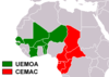 CFA Franc - Map of participating countries |
| 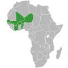 UEMOA - Acceding countries map 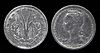 1 CFA Franc coin |
Below are the links to know the current exchange rate with the main world currencies:
| (EN) With Google Finance: | AUDCADCHFEURGBPHKDJPYUSD |
| With Yahoo! Finance: | AUDCADCHFEURGBPHKDJPYUSD |
| (EN) With XE.com: | AUDCADCHFEURGBPHKDJPYUSD |
| (EN) With OANDA.com: | AUDCADCHFEURGBPHKDJPYUSD |
At the table
Tourist infrastructure
Events and parties
National holidays
| Date | Festivity | Note | |
|---|---|---|---|
| January | New Year | International holiday | |
| March | Boganda party | Memorial of the death of the first president of the republic Barthélemy Boganda (1959) | |
| March April | Easter, Easter Monday | Christian holiday | |
| May | Workers Day | International holiday | |
| May June | Ascension, Whit Monday | Christian holiday | |
| June | Feast of prayer | ||
| August | Independence Day | Independence from France (1960) | |
| August | Assumption | Christian holiday | |
| November | All Saints | Christian holiday | |
| December | Republic Day | Memorial of the birth of the Central African Republic (1958) | |
| December | Christmas | Christian holiday that marks the birth of Christ | |
Muslim holidays are celebrated only by the faithful of Islam locally and are not considered national holidays.
Safety
Before embarking on the journey consult:
- Safe travel - Ministry of Foreign Affairs (Farnesina) (Country safety information).
The country is in full civil war and every area is considered dangerous, therefore any trip to the country is not recommended.
Health situation
In 2011, 4.6% of the population was infected with HIV and the most important diseases in the country are: hepatitis A, typhoid fever, malaria, meningococcal meningitis.
Respect the customs
Locals often eat with their hands, so if you join them by eating with your hands, be sure to do it with your right hand, as the left is usually used as a toilet.
How to keep in touch
Other projects
 Wikipedia contains an entry concerning Central African Republic
 Commons contains images or other files on Central African Republic
 Wikiquote contains quotes from or on Central African Republic
 Wikinews contains current news on Central African Republic
![]() Algeria ·
Algeria · ![]() Angola ·
Angola · ![]() Benin ·
Benin · ![]() Botswana ·
Botswana · ![]() Burkina Faso ·
Burkina Faso · ![]() Burundi ·
Burundi · ![]() Cameroon ·
Cameroon · ![]() Cape Verde ·
Cape Verde · ![]() Chad ·
Chad · ![]() Comoros ·
Comoros · ![]() Ivory Coast ·
Ivory Coast · ![]() Egypt ·
Egypt · ![]() Eritrea ·
Eritrea · ![]() eSwatini ·
eSwatini · ![]() Ethiopia ·
Ethiopia · ![]() Gabon ·
Gabon · ![]() Gambia ·
Gambia · ![]() Ghana ·
Ghana · ![]() Djibouti ·
Djibouti · ![]() Guinea ·
Guinea · ![]() Guinea-Bissau ·
Guinea-Bissau · ![]() Equatorial Guinea ·
Equatorial Guinea · ![]() Kenya ·
Kenya · ![]() Lesotho ·
Lesotho · ![]() Liberia ·
Liberia · ![]() Libya ·
Libya · ![]() Madagascar ·
Madagascar · ![]() Malawi ·
Malawi · ![]() Mali ·
Mali · ![]() Morocco ·
Morocco · ![]() Mauritania ·
Mauritania · ![]() Mauritius ·
Mauritius · ![]() Mozambique ·
Mozambique · ![]() Namibia ·
Namibia · ![]() Niger ·
Niger · ![]() Nigeria ·
Nigeria · ![]() Central African Republic ·
Central African Republic · ![]() Republic of the Congo ·
Republic of the Congo · ![]() Democratic Republic of Congo ·
Democratic Republic of Congo · ![]() Rwanda ·
Rwanda · ![]() São Tomé and Príncipe ·
São Tomé and Príncipe · ![]() Senegal ·
Senegal · ![]() Seychelles ·
Seychelles · ![]() Sierra Leone ·
Sierra Leone · ![]() Somalia ·
Somalia · ![]() South Africa ·
South Africa · ![]() Sudan ·
Sudan · ![]() Southern Sudan ·
Southern Sudan · ![]() Tanzania ·
Tanzania · ![]() Togo ·
Togo · ![]() Tunisia ·
Tunisia · ![]() Uganda ·
Uganda · ![]() Zambia ·
Zambia · ![]() Zimbabwe
Zimbabwe
States de facto independent: ![]() Somaliland
Somaliland
Territories with status indefinite: ![]() Western Sahara
Western Sahara
Addictions French: ![]() Mayotte ·
Mayotte · ![]() Meeting ·
Meeting · ![]() Scattered islands of the Indian ocean
Scattered islands of the Indian ocean
Addictions British: ![]() Saint Helena, Ascension and Tristan da Cunha
Saint Helena, Ascension and Tristan da Cunha
African territories Italians: ![]() Lampedusa ·
Lampedusa · ![]() Street lamp
Street lamp
African territories Portuguese: ![]() Madeira (
Madeira (![]() Wild Islands)
Wild Islands)
African territories Spaniards: ![]() Ceuta ·
Ceuta · ![]() Canary Islands ·
Canary Islands · ![]() Melilla ·
Melilla · ![]() Plazas de soberanía (Chafarinas · Peñón de Alhucemas · Peñón de Vélez de la Gomera · Perejil)
Plazas de soberanía (Chafarinas · Peñón de Alhucemas · Peñón de Vélez de la Gomera · Perejil)