

The A10 Tauern Autobahn is an Austrian motorway that is important for transit traffic, especially to south-east Europe, and the one in the Austrian federal states Salzburg and Carinthia runs. It runs from the Salzburg node to the West Highway A1 through the Radstadt Tauern and the Lungau as well as through the Katschberg tunnel in the valley of the Lieser in Carinthia, reached in Spittal an der Drau the valley of the Drava and follows this downstream to after Villach. There it ends at the Villach junction on the South highway A2 and goes into the Karawanken Autobahn A11 over that after Slovenia continues.
The motorway is part of the European route 55 and thus one of the major main connections of the European road network as well as part of the European route 66.
The length of the motorway from the Salzburg junction to the Villach junction (excluding feeder) is around 182 km.
background
The entire length of the Tauern Autobahn was opened in 1988. However, the second tunnel tubes of the Tauern tunnel and the Katschberg tunnel did not go into operation until 2009 and 2011, respectively.
Regions
particularities
Like (almost) all Austrian motorways, the "Tauern Autobahn" is also vignette required! However, the route toll is only partially applicable here. A special toll is collected for the top section between Flachau and Rennweg (in 2020 EUR 12.50 per one-way route, which is generally paid at the St. Michael toll station; cheaper with a subscription). The mileage count (and parallel counting of the connection points) begins at the Salzburg junction and rises to the Villach junction.
traffic
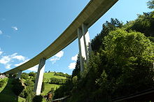
The four-lane motorway, which has been four-lane since 2011, is one of the most heavily frequented Alpine crossings (also as part of the former guest worker route). Traffic jams and block handling during vacation times must therefore be expected. For immission and noise protection reasons, there are speed limits in the state of Salzburg that are below the general Austrian speed limit!
Route


The route is described from north to south (direction of travel south = ![]() ), i.e. from the Salzburg node to the Villach node.
), i.e. from the Salzburg node to the Villach node.
 0 Salzburg node
 8Salzburg-South
  160
160- 11 Puch / Urstein
- 16Hallein
- 22Kuchl159
- 28Golling162
- 34 Pass Lueg
- 43Throw159 (Partial connection)
- 44Parish throw (Partial connection)
- 47Pongau/Bischofshofen
 (Feeder)
 - 56Huettau/Lammertal
 (Partial connection)
 - 60In Pongau

- 63Altenmarkt/ Ennstal

- 66Flachau
- 74Flachauwinkl
- Tauern tunnel 6401 m
- 92Cedar house
- 104St. Michael

- Katschberg tunnel 5429 m
- 113Run away
- 129Gmuend/Maltatal
- 139 Spittal node /Millstätter See (Feeder)
- 146Spittal an der Drau-East

- 158Paternion/Feistritz
- 172Villach-West
- 178Villach/Ossiacher See

- 182 node Villach


security
trips

literature
- Bernd Kreuzer: The construction of the motorways and expressway in Austria. - In: ASFINAG (ed.): The motorway network in Austria. 30 years of Asfinag. Vienna 2012, pp. 84-87