| Tramonti di Sopra | ||
 | ||
| State | Italy | |
|---|---|---|
| Region | Friuli Venezia Giulia | |
| Territory | Friuli valleys and Dolomites | |
| Altitude | 420 m a.s.l. | |
| Surface | 125.15 km² | |
| Inhabitants | 292 (2019) | |
| Name inhabitants | Tramontini | |
| Prefix tel | 39 0427 | |
| POSTAL CODE | 33090 | |
| Time zone | UTC 1 | |
| Patron | San Floriano (May 4) | |
Position
| ||
| Institutional website | ||

Tramonti di Sopra is a center of the Friuli Venezia Giulia.
To know
In the village there is a Waldensian Evangelical church.
Geographical notes
It is located in the upper Val Tramontina, in the area of Friuli valleys and Dolomites.
Background
In 1976 the town was devastated by the earthquake of Friuli, which caused massive collapses and damage.
How to orient yourself
The municipal territory also includes the hamlets of Chievolis, Inglagna and Redona.
- 1 Picnic area in via Pradis telephone 338 195 0319
How to get
By plane
![]()
- 2 Friuli-Venezia Giulia Airport, via Aquileia 60 (in Ronchi dei Legionari), ☎ 39 0481 773224.
- 3 Marco Polo Airport in Venice, viale Galilei (to Tessera), ☎ 39 041 2609260.
- 4 Verona Airport (Catullus), Boxes of Sommacampagna, ☎ 39 045 8095666, @[email protected].
By car
- from Pordenone towards Maniago (SS 251), continue towards Meduno up to Tramonti di Sopra (SS 552).
- from Pordenone via Fiume Veneto (SS 13), take the freeway Cimpello/Sequals, Sequals exit, continue for Meduno up to Tramonti di Sopra (SS 552).
- from Udine towards Dignano (SS 464), up to Spilimbergo, continue for Sequals, towards Meduno up to Tramonti di Sopra (SS 552).
- from Tolmezzo towards Villa Santina (SS 52), continue towards Socchieve, take the Monte Rest Pass (SS 552), and the Val Tramontina up to Tramonti di Sopra.
On the train
- 5 Railway station (in Maniago). The closest station is that of Maniago on the railway line Sacile - Pinzano. From 6 July 2012 to 9 December 2017, the railway service was replaced by self-rides due to the diversion of a train due to a landslide on the railway site near the Meduno station.
- With the partial reopening of the line, from 10 December 2017 the station is again served by Regional trains in service between Sacile and Maniago. In addition to serving the city in which it is located, the station plays an important role as a hub for the surrounding valleys.
By bus
- Direct and daily connections by bus from Udine, Pordenone, Spilimbergo is Maniago.
How to get around
What see

The Lake of Tramonti or Lake of Redona

Dam of Cà Selva

Dam of Cà Zul
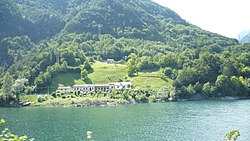
- 1 Lake of Tramonti (lake of Redona). It is an artificial lake located in Val Tramontina between the municipalities of Tramonti di Sopra and Tramonti di Sotto formed following the construction in 1952 of a dam in Ponte Racli. The crowning is accessible, and is part of the access roadway between the state road 552 of Passo Rest, (now regional), the hamlets Chievolis, Inglagna, Posplata and the other two hydroelectric plants not far away that exploit the Meduna river course: the lake of Cà Selva and the lake of Cà Zul.
- The damming of the Meduna led to the abandonment of the old village of Movada, whose remains still emerge when the lake is dry.


- 2 Lake of Cà Selva. It is an artificial basin located between the municipalities of Frisanco and Tramonti di Sopra. The lake surface falls within the southeastern borders of the Natural park of the Friulian Dolomites.
- The arch dam on the Silisia stream is 111 m high and the works for its construction were completed in 1963. The name of the reservoir derives from the locality near Chievolis, a hamlet of Tramonti di Sopra, where the dam was built.
- The Cà Selva lake is often associated with two other nearby artificial lakes: the Cà Zul lake and the Redona lake (also known as the Tramonti lake), in Val Tramontina.
Access
- To reach the lake, take the SS 552 up to the Tramonti dam, cross its crown and continue towards Chievolis. Then continue along the asphalted road, indicated by the signs, which rises in altitude in a natural landscape. After several kilometers you arrive at the small village of Cà Selva and immediately meet the artificial dam of the lake. The dam is extremely suggestive and of great visual impact; the crowning is accessible.
- Shortly before the dam, the road leading to the furthest lake of Cà Zul starts.
_01.jpg/220px-Chiesa_di_San_Floriano_(Tramonti_di_Sopra)_01.jpg)
- the church of San Floriano
- 3 Lake of Cà Zul (lake of the Ciul; Lâc from Çûl in standard Friulian). It is an artificial basin located in the municipal area of Tramonti di Sopra. The reservoir, obtained from the damming of the Meduna stream, falls entirely within the eastern borders of Natural Park of the Friulian Dolomites.
- The Cà Zul lake is often associated with two other artificial lakes not far away: the Redona lake (also known as the Tramonti lake) and the Cà Selva lake. The lake, which is located in an isolated position, can be reached via paths or along the dirt road (where access is prohibited, as it is private property) which is located near the Cà Selva dam.
- Parish Church of San Floriano.
- 4 Parish Church of the Madonna della Salute, Via Roma, 13.
Events and parties
What to do
Shopping
How to have fun
Where to eat
Average prices
- La Tana delle Pitine, via Sisto 1.
Where stay
Moderate prices
- 1 Paisa house, Paisa locality, ☎ 39 0421 310710.
Average prices
- 2 Agriturismo Borgo Titul farm, Location Titol, 1, ☎ 39 335 8222876.
Safety
How to keep in touch
Post office
- 6 Italian post, Via Roma, 3, ☎ 39 0427 869393.
Around
Useful information
- 7 IAT - Tourist information office, Village VI Maggio, 3, ☎ 39 0427 869412.
Other projects
 Wikipedia contains an entry concerning Tramonti di Sopra
 Commons contains images or other files on Tramonti di Sopra