 | ||
| Baligród | ||
| Voivodeship | Subcarpathian | |
|---|---|---|
| Residents | unknown | |
| no value for residents on Wikidata: | ||
| height | 340 m | |
| no tourist info on Wikidata: | ||
| location | ||
| ||

Baligród is a mountain town in the voivodeship Subcarpathian in the southeast Poland in the Bieszczady in the Forest Carpathians at the edge of the Bieszczady National Park, west of Solina reservoir.
background


The place was first mentioned in 1615 and received city rights before 1634. The city developed thanks to the Hungarian trade, a large part of the population were Jewish settlers. With the First Partition of Poland, it came to the Habsburgs. It became Polish again after the First and Second World Wars. During the Carpathian Battle of 1915, the city was largely destroyed and lost its city rights.
getting there
By plane
The international John Paul II Airport Krakow-Balice![]()
![]()
![]()
![]() (IATA: CRC) located northwest and the international Rzeszów-Jasionka Airport
(IATA: CRC) located northwest and the international Rzeszów-Jasionka Airport![]()
![]()
![]()
![]() (IATA: RZE) north of Baligród.
(IATA: RZE) north of Baligród.
.jpg/320px-John_Paul_II_Airport_in_Balice-Kraków_night_november_2017(3).jpg)

By train
Baligród is by train from Krakow reachable. The place is south of the railway line Nowy Sącz-Sanok. In Zagórz you have to change to the bus.
By bus
Regional buses go to Rzeszów and the surrounding towns.
In the street
The connecting road leads up to the river Bieszczady National Park. The country road DK 28 leads north past the place.
mobility


The place is easy to explore on foot or by bike. Since it is quite hilly, you need a certain level of fitness. It is best to have your own set of wheels to explore the area.
Tourist Attractions
- Marienkirche
- modern Church of Mercy
- Greek Catholic Church
- Michalskirche Roztoki Dolne
- Greek Catholic basil church Żernica Wyżna
- Jewish Cemetery
- War memorial

Church of Mercy

Marienkirche

Greek Catholic Church
.jpg/120px-Roztoki_Dolne,_cerkiew_św._Michała_Archanioła_(HB2).jpg)
Michalskirche Roztoki Dolne

Basil Church Żernica Wyżna
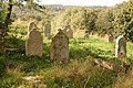
Jewish Cemetery

War memorial


.jpg/120px-Roztoki_Dolne,_cerkiew_św._Michała_Archanioła_(HB2).jpg)


activities
The place invites to hiking and cycling in the nearby mountains, in the cold season for winter sports. At the nearby Solina reservoir water sports can be practiced.
shop
Souvenirs and everyday items can be purchased on site. For shopping you should go to Krosno.
kitchen
There are several restaurants. For Polish cuisine, see the relevant section in the article Poland.
nightlife
The best way to celebrate is to go to Krosno.
accommodation
Guest rooms and pensions are available.
security
It's pretty safe.
health
The nearby health resort Polańczyk has medical practices, pharmacies and health facilities.
Practical advice
trips
literature
See article too Poland.
Web links
- An official website is not known.