| Castel Ivano Castel Ivano | ||
.JPG/250px-Valsugana_da_Lefre_(W).JPG) | ||
Coat of arms  | ||
| State | Italy | |
|---|---|---|
| Region | Trentino Alto Adige | |
| Territory | Lower Valsugana and Tesino | |
| Altitude | 506 m a.s.l. | |
| Surface | 34.82 km² | |
| Inhabitants | 3.303 (2019) | |
| Prefix tel | 39 0461 | |
| POSTAL CODE | 38059 | |
| Time zone | UTC 1 | |
| Patron | Immaculate Conception | |
Position
| ||
| Tourism site | ||
| Institutional website | ||

Castel Ivano is a scattered municipality of the Trentino Alto Adige, precisely of the Trentino, made up of the towns of Strigno, Spera, Ivano-Fracena, Villa, Agnedo and Tomaselli.
To know
Geographical notes
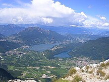
Castel Ivano is located in Trentino, in the tourist area of the Lower Valsugana and Tesino, about 20 km from the border with Veneto and the territory of Vicenza. Located along the Valsugana, the northern part of the municipal territory is immersed in the Lagorai mountain range, which separates it from the Val di Fiemme, while from the southern side rise the Venetian Pre-Alps of Cima XII-Ortigara leading toAsiago plateau.
When to go
Compared to most of the tourist destinations in Trentino, which have focused their tourist offer on the winter season, the eastern Valsugana is more suitable for visiting during the warm months of the year. It is therefore preferable to visit the territory of Castel Ivano in spring, summer and autumn, starting from April until October.
Background
The territory of Castel Ivano was part of the jurisdiction of the castle of the same name, seat of the local lords. In the early Middle Ages power was held by the Bishop of Feltre, who disputed the territory of Valsugana with the Episcopal Principality of Trento. During the 14th century the jurisdiction of Ivano passed under the direct control of the Counts of Tyrol.
The entire area became part of Italy at the end of the First World War, a conflict that directly affected the territory causing the destruction of all the inhabited centers, as well as the death and forced transfer of most of the civilian population. The ancient jurisdiction of Castel Ivano lived separately in 8 different municipalities until 2015, when the merger between Strigno, Spera and Villa Agnedo took place. In 2016 Ivano-Fracena was also added. In 2017 he was awarded the title of township for historical reasons.
How to orient yourself
Being a scattered municipality, the municipal area is relatively large (34.82 km²), with an altitude ranging from 320 m a.s.l. of the valley floor near the Brenta river to over 2,000 both of the mountain range to the south (Venetian Prealps - Cima XII - Ortigara) and to the north (Lagorai - Cima d'Asta). All the inhabited centers and localities that make up the municipal territory are connected by practical roads that have Strigno (municipal seat) as their fulcrum. The municipal administration recognizes the presence of 6 hamlets and various localities.
Fractions
- Strigno: municipal seat and main center of the area since the nineteenth century; the main public services of the municipality are located in this hamlet
- Hope: westernmost fraction of the municipality, it is developed with an east-west trend along the southern slopes of Col Fatero
- Villa: first part of the municipality of Villa Agnedo, it rises on the right of the Chieppena stream, along the connection between the valley floor and the northern hamlets
- Agnedo: first part of the municipality of Villa Agnedo, located on the left of the Chieppena stream, at the foot of the hill of the castle of Ivano
- Ivano-Fracena: inhabited center enclosed between the west wall of Monte Lefre and the castle of the same name
- Tomaselli: former fraction of the municipality of Strigno, it developed around the road that leads to the Tesino plateau
Other smaller groups of houses make up the localities of Barricata, Castrozze, Latini, Lupi, Oltrebrenta, Pellegrini, Torgheli and Primalunetta.
How to get
By plane
![]()
- 1 Treviso-Sant'Angelo Airport (IATA: TSF) (The property is 96 km from Castel Ivano). Airport of European interest with low-cost flights.


- 2 Bolzano-Dolomites Airport (IATA: BZO) (110 km from Castel Ivano). Small regional airport with scheduled flights to and from Lugano, Rome is Vienna.
- 3 Venice-Marco Polo Airport (IATA: VCE) (130 km from Castel Ivano). Main airport in the North-East, with scheduled and low-cost flights.
- 4 Verona-Villafranca Airport (IATA: VRN) (141 km from Castel Ivano). International airport, dedicated to low-cost flights.
- 5 Innsbruck-Kranebitten Airport (IATA: INN) (216 km from Castel Ivano). Austrian stop with scheduled and low-cost flights.
- 6 Bergamo-Orio al Serio Airport (IATA: BGY) (225 km from Castel Ivano). Support stop at Milan-Malpensa airport.
By car
 A22 motorway, Trento Sud and Trento Nord exits, then
  state road 47 of the Valsugana towards Padua
 A4 motorway, Padova Ovest exit, then state road 47 of the Valsugana towards Trento
 Provincial road 31 of Passo Manghen from Val di Fiemme up to Borgo Valsugana, then provincial roads heading east
 Provincial road 78 of Tesino from Primiero, after the Brocon Pass, descent to the Tesino plateau and then to the town of Castel Ivano
By bus
All the inhabited areas of the municipality of Castel Ivano are served by the extra-urban service provided by the company Trentino Trasporti. Falling back into the Zone 4 - Valsugana, the main connection with the provincial capital is the line B401 which connects Trento to Borgo Valsugana, from whose intermodal station it is then possible to take the following lines:
- B405: Borgo Valsugana - Strigno - Tesino Castle
- B406: Borgo Valsugana - Carzano - Strigno - Samone
- B410: Borgo Valsugana - Tezze - Primolano
On the train

At the bottom of the valley runs the railway that connects Trento with Bassano del Grappa and Venice. The town is served by a station, named after the old town of Strigno.
- 7 Strigno station. Railway station serving the municipality of Castel Ivano.
It is not possible to reach Castel Ivano through waterways.
By bike
Along the course of the Brenta river, the Valsugana Ciclopista develops, which connects the Levico lakes and Caldonazzo with Bassano del Grappa. Near the Strigno railway station, a cycle path branches off from the cycle path that allows you to reach the towns of the municipality of Castel Ivano.
How to get around
Movement within the municipal area is mainly entrusted to private vehicles. Connections provided by public services fall within the suburban bus lines indicated in the previous paragraph.
By car
- There
 provincial road 39 connects Strigno with the neighboring municipality of Samone.
 - There
 provincial road 41 connects Strigno with the neighboring town of Scurelle.
 - There
 provincial road 42 connects the districts of Strigno and Spera.
 - There
 provincial road 60 connects Ivano-Fracena and Agnedo with the neighboring municipality of Ospedaletto.
 - There
 provincial road 65 connects Villa with the neighboring town of Scurelle.
What see
Military architectures
- 1 Castel Ivano, Via al Castello, 1, ☎ 39 0461 763432, @[email protected]. Castle of medieval origin, ideal place for organizing events (meetings and weddings). Group guided tours can be booked.
- 2 Giuseppe De Gol Barracks, Via Guglielmo Marconi. Barracks of Austro-Hungarian construction, played an important role during the First World War.
Religious architectures
- 3 Church of the Immaculate Conception, 4th November Square. Church dating back to the thirteenth century, it is the main religious building of the deanery.
- 4 Church of the Madonna of Loreto, Via Pretorio. Strigno cemetery church, contains a statue of the black Madonna.
- 5 Church of Santa Agata, Via Sant'Agata. Main church of the Tomaselli hamlet.
- 6 Church of Santa Maria Assunta, Via Cenone. Main church of the Spera district.
- 7 Church of Santa Apollonia, Via Santa Apollonia. Small church in the Spera district.
- 8 Church of Saints Fabiano and Sebastiano, Piazza Santi Fabiano and Sebastiano. Main church of the Villa hamlet.
- 9 Church of San Giuseppe, Piazza Santi Fabiano and Sebastiano. Main church of the Ivano-Fracena hamlet.
- 10 Church of San Vendemiano, Via San Vendemiano. Small church on the slopes of Mount Lefre.
- 11 Church of the Madonna della Mercede, Piazza Beata Vergine della Mercede. Main church of the Agnedo hamlet.
- 12 Chapel of San Giovanni Battista, Off to the Castle. Chapel of the castle.
- 13 Alpine church of Monte Lefre. Alpine church on Mount Lefre.
- 14 Chapel of Saints Bartholomew the Apostle and Lawrence martyr. High-altitude chapel in Primalunetta.
Civil architectures
- 15 Forge Zanghellini, Via dei Molini. Ethnographic museum mainly dedicated to the blacksmith trade.
- 16 , SP 78 of Tesino. Old social dairy in the Tomaselli district.
- 17 Villa Adelia, Via Salesai. Historic villa of Strigno.
- 18 Villa Franceschini, Via Salesai. Historic villa of Villa.
Other attractions
- 19 "Pietre d'Acqua" Park, Via Don Giuseppe Grazioli. Permanent exhibition of sculpture on granite along the banks of the Chieppena stream.
- 20 Wildlife oasis of Castel Ivano, Via dei Molini. Faunistic oasis in which it is possible to admire deer and roe deer.
- 21 Castelrotto, Tomaselli. Remains of the castle (tower) of the Castelrotto family.
Events and parties

- 8 San Marco Fair (April 25 each year). On the day of San Marco, the center of Strigno hosts a market dedicated to plants and flowers.
- 9 Revolution Fest Agnedo (last weekend of May). Country festival lasting 3 days.
- 10 Water stones (at the beginning of July). Symposium of sculpture on granite, with sculptors from all over Italy and Japan.
- 11 Lights and shadows of the wood (end of July). Symposium of sculpture on wood, in the square of Strigno and the towns of the Tesino plateau.
- 12 Scrozada of Monte Lefre (early August). Non-competitive walk, starting from the Agnedo square and arriving at the alpine church on Monte Lefre, passing through Villa, Ivano and Fracena for a total height difference of about 950 m.
- 13 Almond Festival (December 8 each year). As part of the celebrations for the patron saint's day, the town of Strigno hosts the Almond Festival.
What to do
- 1 Trekking along path 329 to the top of Monte Lefre. Path of 5 560 meters from Fracena to the top of Monte Lefre.
- 2 Trekking on the Rava Group along the Path of Memory. Trekking along the Path of Memory, towards the peaks of Primaluna and Croz di Primalunetta, with a possible stop at the Argentine Bivouac.
- 3 Sport climbing at the Agnedo rock gym. Climbing gym inaugurated in 2018 in the Agnedo Sports Center.
- 4 Sports shooting at the Strigno shooting range. Structure of the early 2000s used for the practice of indoor sports shooting.
- 5 Swim and play beach volleyball at the Strigno swimming pool. Outdoor swimming pool with beach volleyball court and children's pool.
Shopping
Each fraction of the municipality has at least one grocery store, for basic necessities. Further activities are concentrated in the town of Strigno, both in its historic center and along the Tesino SP78. In the historic center there are both food shops (bakery, butcher, clothes shop, etc.) and other services (beautician, florist, etc.). The provincial road, on the other hand, plays somewhat the role of an industrial and commercial area, given the presence of a supermarket, a car dealership, furniture factories, mechanics and construction companies. Other production and retail activities are located along the stretch of the SS47 that passes through the municipal area.
How to have fun
.jpg/220px-Municipio_Strigno_(1).jpg)
Locals
- 1 Freeway Pub, Via Cenone - Spera.
- 2 Central Bar, 4 November Square - Strigno, ☎ 39 339 589 7401.
- 3 Moomba Cafè by Rinaldi, Town Hall Square - Strigno, ☎ 39 0461 762032.
- 4 National Bar, Via 24 Maggio - Strigno.
- 5 Dating Bar, Via Roma - Strigno.
- 6 Bar Villa, Strada del Tesino - Villa.
- 7 Nemo Bar, Strada del Tesino - Villa.
- 8 El Mato Bar, Sports Center - Agnedo.
Where to eat
Average prices
- 1 Al Torchio Pizzeria Restaurant, Via Guglielmo Marconi, 11 (Pizzeria), ☎ 39 0461 762866.
- 2 Hotel Spera, Via Carzano (Restaurant), ☎ 39 0461 762042, fax: 39 0461 782781, @[email protected].
- 3 Wolf Ranch, Castrozze location (Typical Trentino cuisine), ☎ 39 0461 763030, @[email protected].
Where stay
Moderate prices
- 1 B&B Tomaselli, Via Santa Barbara - Tomaselli, ☎ 39 366 981 3815, @[email protected].
- 2 B&B Al Larice, Via Santa Apollonia - Spera, ☎ 39 339 794 5539, @[email protected].
- 3 B&B Elisa, Via Cenone - Spera.
Average prices
- 4 Hotel Spera, Via Carzano - Hope, ☎ 39 0461 762042, fax: 39 0461 782781, @[email protected].
- 5 Wolf Ranch, Castrozze - Strigno, ☎ 39 0461 763030, @[email protected].
- 6 Monte Lefre Refuge, Location Monte Lefre - Ivano-Fracena, ☎ 39 333 4349573.
- 7 Miralefre hut, Locality Lunazza - Strigno, ☎ 39 0461 751114.
Safety
- 14 Carabinieri station, Via Roma, 33 - Strigno, ☎ 39 0461 762117.
- 15 Medical clinic, Piazzetta Luigi Carbonari - Strigno.
- 16 Borsato Pharmacy, Via Roma - Strigno, ☎ 39 0461 762101.
- Each fraction (with the exception of Tomaselli) has a volunteer Fire Brigade, with relative barracks and equipment.
- The branches of the Cassa Rurale Valsugana and Tesino, with the possibility of withdrawing cash at ATMs.
How to keep in touch
Post office
- 17 Italian post, Piazza 4 Novembre, 16 - Strigno, ☎ 39 0461 762023.
Keep informed
To keep informed or request more information, you can contact:
- Municipality of Castel Ivano - Department of Culture[link not working]
- APT Valsugana Lagorai: information request
Around
- Ponte dell'Orco: the Ponte dell'Orco is a natural bridge located on the eastern side of Mount Lefre, in the municipal area of Ospedaletto. It was created due to the erosion of the surrounding material, leaving an arch with a span of about 60 meters. The body of the bridge is about 12 meters thick and about 4 meters wide on the back. The walkable area (on which a path passes) is 72.5 meters long, while the bridge rises 37 meters above the ground. It can be reached from Fracena with a detour from path 329 or through a path coming from the center of Ospedaletto.
- Tesino plateau: Also known as Conca del Tesino, or simply Tesino, is located north-east of Castel Ivano and is composed of the municipalities of Pieve Tesino, Cinte Tesino and Tesino Castle. It is a tourist destination mainly in summer, but also usable in winter thanks to the ski slopes near Passo Brocon. From the pass it is possible to reach the Primiero, on whose territory the famous tourist resort of San Martino di Castrozza.
- Upper Valsugana is Trento: coinciding with the western part of the valley, Alta Valsugana is one of the main tourist destinations in the Trentino thanks to the presence of the Levico lakes and Caldonazzo; inside there are numerous accommodation facilities that allow you to visit the entire eastern Trentino. From here, moreover, it is possible to quickly reach the Mocheni Valley and, a little further west, the city of Trento, seat of the main services of the provincial territory.
- Sella Art: is a review of contemporary art in nature, which takes place in Val di Sella, in the municipality of Borgo Valsugana. It is an international event born in 1986, which takes place outdoors in the meadows and woods of the small valley, making sure that the works of art are not permanent but grow and perish following the course of nature.
- Plateau of the Seven Municipalities: it is a vast plateau located in the Vicenza Alps, in the border area between Veneto and Trentino-Alto Adige, in the Territory of Vicenza. Included between the rivers Astico and Brenta, it is an important tourist area both in summer and in winter, where Nordic skiing is particularly practiced, thanks to an extensive network of ski slopes.
Other projects
 Wikipedia contains an entry concerning Castel Ivano
 Commons contains images or other files on Castel Ivano